
Held at: | Private collection |
Reference: | gc |
Source: | Research on Tithe Map schedule |
Title: | Some Land owners in part of St Margarets, Map 9 |
Place name: | St Margarets |
Date: | 1844 |
Description:
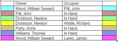
Some properties and their owners in part of St Margarets at the time of the Tithe map of 1844
Holding | Owner | Occupier |
Land | William Seward Wood | John Pitt |
Lower Gilva | John Pitt | In Hand |
Land | Newton Dickinson | In Hand |
Part of Chanson Farm | Newton Dickinson | Richard Wintle |
Land | Anne Parry | In Hand |
Land (see also map 6) | Thomas Williams | In Hand |
House (plot 539) | William Seward Wood | James Lewis |
|
|
|
House (plot 512) | Anne Parry | William Jones |
House (plot 513) | Anne Parry | William Pitt |
Plot 512 is adjoining field 511 and is uncoloured on the map
Plot 513 is adjoining field 511 and is uncoloured on the map
|

to see associated maps click here
Observations:
None
Ref: gc_stm_3009