
Held at: | Private collection |
Reference: | gc |
Source: | Research on Tithe Map schedule |
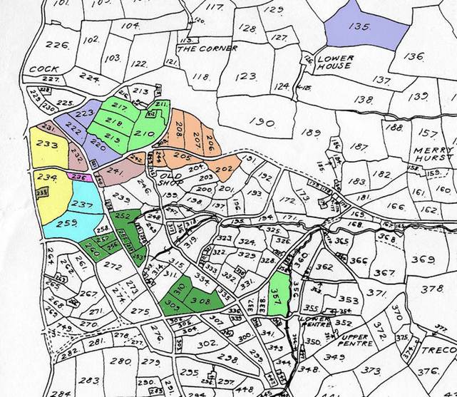
Title: | Some Land owners in part of St Margarets, Map 3 |
Place name: | St Margarets |
Date: | 1844 |
Description:
Some properties and their owners in part of St Margarets at the time of the Tithe map of 1844. Including that part of St Margarets known as the Upper Maescoed.
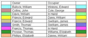
Holding | Owner | Occupier |
Land | William Bullock | Edward Wistons |
House | John Collins | George Cole |
Land | William Davis | In Hand |
Land | Edward Francis | William Davis |
House | Edward Francis | James Gwilliam |
House | Thomas Smith | James Gwilliam |
Land | Thomas Francis | In Hand |
House | Thomas Prosser | Elizabeth Williams |
House | Elizabeth Phillips | William Davies |
--- |
|
|
House (plot 212) | William Davis | Thomas Jenkins |
House ( plot 238) | Joseph Pitt | Priscilla Preece |
House ( plot 251) | Joseph Pitt | William Seabourne |
Plot 212 is adjoining field 213 and is uncoloured on the map
Plot 238 is adjoining field 239 and is uncoloured on the map
Plot 251 is adjoining field 252 and is uncoloured on the map
|
to see associated maps click here
Observations:
Many of the small holdings on this map are in the area known as the Upper Maescoed. Upper Maescoed originally an open Common that was, over a long period of time, subject to piecemeal enclosure. The properties were mostly copyholds held for ‘lives’ by ancient custom of the Manor. They are recorded by copy in the rolls of the Court Baron. Many were included in the 1920 Estate Sale of the Marquees of Abergavenny.
Ref: gc_stm_3003