
Held at: | Hereford Record Office |
Reference: | Microfilm |
Source: | Schedule of Llancillo Tithe map |
Title: | Owners and Occupiers of Land in Llancillo |
Place name: | Llancillo |
Date: | 1840’s |
Description:
Owner | Occupier | Holding | Acres-roods-perches | See |
Barneby, John Esq | Griffiths, Thomas | The Pool Farm | 61-0-8 | 1 |
Gabb, Baker John | Williams, William | Part of Great Goytrey Farm | 5-2-38 | 2 |
George, James Gilbert Esq | Phillips, William | Upper House Farm | 63-3-21 | 1 |
Howells, William | Self | Pwllyrhunt Farm | 21-0-3 | 4 |
Howells, William | Self | Sunny Bank | 23-1-22 | 4 |
Morris, Rev John | Price, James Gilbert | Baynam Farm | 36-2-29 | 2 |
Parry, John | Self | Cottage | 0-1-32 | 1 |
Parry, Thomas | Jones, Lewis | Land | 0-1-0 | 1 |
Powell, James | Lewis, William | Part of cottage | 0-0-26 | 1 |
Powell, James | Self | Penyrheol Farm | 9-2-28 | 1 |
Price, James Gilbert Esq | Black, James | Cottage | 0-0-38 | 2 |
Price, James Gilbert Esq | Gilbert, David | Goytrey Cottage | 0-1-37 | 2 |
Price, James Gilbert Esq | Johnson, Samuel | The Lodge Farm | 117-1-9 | 2 |
Price, James Gilbert Esq | Self | Goitre Farm | 75-3-16 | 2 |
Price, James Gilbert Esq | Self | Llancillow Hall Farm | 187-3-8 | 2 |
Price, John Gilbert Esq | Johnson, Samuel | Arcadia Farm | 116-1-14 | 1 |
Pritchard, Thomas | Self | Cottage | 0-1-15 | 3 |
Russell, Joseph | Self | Little Sunny Bank Farm | 18-0-2 | 4 |
Scudamore, John Lucy Esq | Cooke, Thomas | Land | 33-2-6 | 4 |
Scudamore, John Lucy Esq | Edwards, John | Llancillo Court | 314-0-17 | 3 |
Scudamore, John Lucy Esq | Howells, William | Land | 1-0-38 | 4 |
Scudamore, John Lucy Esq | Jones, William | Land | 17-3-1 | 4 |
Scudamore, John Lucy Esq | Self | Land | 11-1-9 | 4 |
Scudamore, John Lucy Esq | Williams, John | House | 0-3-4 | 4 |
Scudamore, John Lucy Esq | Morgan, John | High House | 0-1-0 | 4 |
Wall, George | Self | Land | 8-1-17 | 4 |
|
| Church and Yard | 0-1-20 | 3 |
|
| The Roads | 9-0-18 |
|
|
| The River Monnow | 14-2-0 |
|
|
| Total | 1085-3-30 |
|
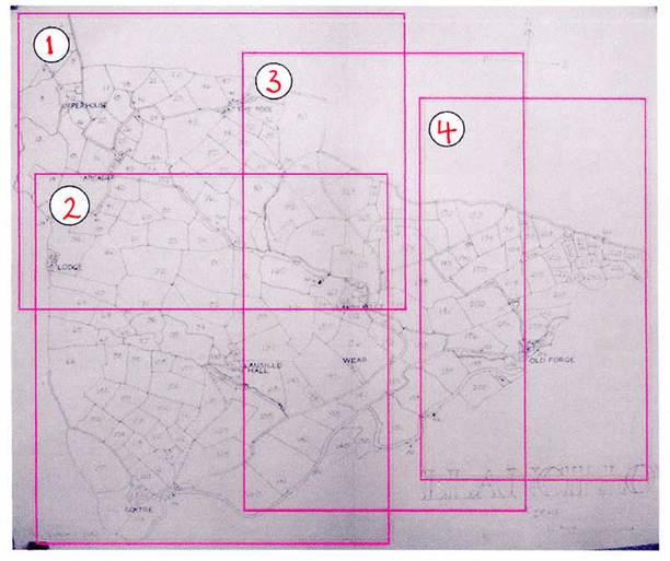
To see map extracts click below
|
|
key to juxtapostion of map extracts |
Observations:
Not all holdings are associated with a farm or a homestead and not all holdings are named in the schedule.
|
|
|
for similar Tithe map details of other Ewyas Lacy parishes click here
Ref: nw_llc_3000