
Held at: | Private Collection |
Reference: | RS |
Source: | Guest Contribution |
Title: | Digital Archive: ‘Celebrating St Margarets’ Festival |
Place name: | St Margarets |
Date: | 2025 |
Description:
As part of a Festival celebrating the Church and Parish of St Margarets, local historian Neville Fleet compiled summaries of the history of a variety of aspects of the area. These are reproduced below with the author’s kind permission.
Ewyas Lacy Study Group
Celebrating St Margarets Festival
Index:
St Margarets Population & Professions
------------------------------------------------------------------------
“My own memory of the perfect Herefordshire is a spring day in the foothills of the Black Mountains and finding among the winding hilltop lanes the remote little church of St. Margaret’s where there was no sound but a farm dog’s distant barking. Opening the church door I saw across the whole width of the little chancel a screen and loft all delicately carved and textured pale grey with time”
Sir John Betjeman
The church is included in Simon Jenkin's England's Thousand Best Churches .
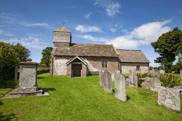
This historic church is situated at the south end of the Parish of St Margarets, standing nearly 800 feet above sea level with magnificent views to the hills of Dinedor, Aconbury, and Garway and westward to the Black Mountains.
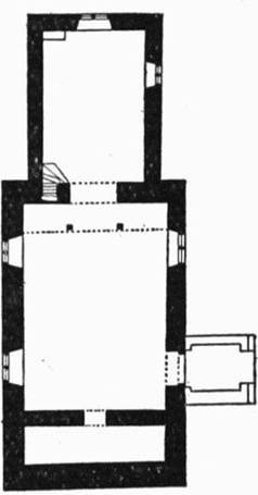
The building itself is a relatively simple two-cell church of Norman origin with a low nave and chancel, bellcote tower and a small south porch, and is noted for a rare surviving example of a rood screen carved in oak. The slight inward sloping of the external walls points to an existing Norman Church.
It is of stone construction with a locally quarried stone tiled roof, and externally is more Welsh than English, as were many of the other churches in the Hundred of Ewyas Lacy. The church was in the diocese of St Davids until 1852.
The exterior consists of shaly rubble with local sandstone dressing and stone slates. The Chancel roof dates from the 14th century when this part of the church was rebuilt and is a typical trussed rafter collar-beam construction with short, straight braces from the rafters to the collars. The Nave roof dates from the late 15th century and has arch-braced collar beams with side and ridged purlins. This was reconstructed in 1902 and only one of the moulded tie beams remains. The overall roof is a type common to those centuries and would have been known as a “Marcher” roof.
The interior contains a simple octagonal font, probably 14th century, although this could be as late as the 17th century, the date of its panelled cover. The chancel arch dates to the 12th century, although could be as early as late 11th century.
The church is noted for its beautiful carved oak rood screen, one of only five or six remaining in England, and probably the finest … being described by Nikolaus Pevsner as one of the wonders of Herefordshire. The screen dates to 1527. The screen has two carved and gilded posts with niches that would originally have held figures of the Virgin Mary and St John. At festivals these would have been covered with garlands, but at Lent covered with veils. The front of the loft is divided into twenty simple panels by moulded muntins, with rails at the top and bottom of the screen covered with a running foliage design. The underside of the loft is decorated with twenty or so small bosses, carved with foliage, interlaced knots, shields and human faces … one with hanging tongue and one supposedly the face of the carpenter.
The screen would have been richly painted and gilded when first installed … similar to the one in St Teilo’s Church in St Fagans National Museum of History. Some idea of this pre-reformation magnificence can still be seen at Blisland and Little Petherick in Cornwall. Other fine examples may be found along the Welsh Border, the nearest being the churches in Partrishow, Llanfilo and Llanano in Powys. Others are Llanegryn in Gwynedd and Llangum in Pembrokeshire.
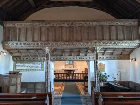
The First Act of Uniformity in 1549 decreed that all such rood screens, any icons of saints, and all wall paintings be removed … luckily either the remoteness of the church at the end of a windy lane (not even today’s postcode is that accurate) or the defiant spirit of the local congregation prevented this. In the same year the First Book of Common Prayer was introduced in English … a transformation from the remoteness and mystery of the Latin services.
The Chancel is the oldest part of the church, separated from the Nave by an arch mainly obscured by the rood screen. This dates from the 12th century (possibly even the late 11th century) and hints that the church was built after the Norman conquest. The founder of the church is unknown although it was possibly the Abbot of Dore Abbey. A settlement would have appeared around the church during the late 12th and early 13th century, and it is likely that the placename for St Margarets is much more recent than that of the church. This Norman east end of the church was partly reconstructed, possibly at the start of the 14th century as evidenced by the date of the cinquefoil leaded windows in the south wall.
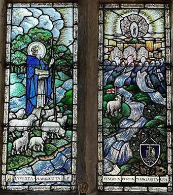
The East window probably dates from the late 16th or early 17th century, although the stained glass in this window is a modern representative of Saint Margaret as a shepherdess, carrying a replica of the church on her right arm. This is the work of Archibald Davies (1878-1953) whose other designs can be found in both Hereford and Worcester Cathedrals, and in other cathedrals and churches throughout the world, including Johannesburg Cathedral.
A narrow door to the north of the arch leads up a flight of very steep stone steps, cut within the thickness of the wall, to the rood loft. The altar rails have heavy turned mirrored balusters most likely from the 17th century. The two panelled chairs with turned front legs, carved rails and shaped arms date from the same time. A plaque, dated 1574, displays in the memento mori tradition in Welsh the words Karka dy ddiwwedd ("remember your end ").
The Nave is later than the chancel with the present structure dating from the late 15th century, as evidenced by the window nearest the pulpit in the north wall. The western window in the north wall is modern, having been inserted in the old north doorway, with straight joints below the sill showing the position of the doorway. The single window in the south wall is from a later century, although still has square leaded lights with a moulded mullion and jambs.
The tomb recess in the south wall, partly hidden by pews, probably dates from around 1300, but it is not known who it was for.
The walls boast a number of restored wall paintings of Biblical texts typical of the 18th century, including one above the south door that requests that you “Go and Sin no more ”. These were restored in 1974 by Mr Maxwell Jones of Redditch. There were possibly skeletons painted on the walls of the church, similar to those in Dore Abbey, but none remain today.
The doorway into the Nave and thus the church is from the 13th century, although could be later. The west jamb of this door has a small carved cross, most likely carved by a pilgrim to give thanks for their safe return from a trip to a holy place.
The Vestry contains a panelled chest from 1650 with the lid in two parts for easy opening. On the wall is a list of ‘The Duty of Churchwardens’ in English and Welsh. Above the vestry is a weather-boarded turret containing three bells. The smallest is inscribed ‘Peace and good neighbourhood, W.E. 1745’ . The bell founder was William Evans of Chepstow and the inscription is the blessing which is said at the distribution of Pax Cakes on Palm Sunday in the Herefordshire churches of Hentland, Sellack and Kings Caple. The second bell would have been around the same time, but the third is much earlier as it bears the inscription ‘Ave Maria Ora pro Nobis’ . These two bells also bear the inscription ‘Recast by John Warner and Son, London 1907’.
Perhaps it was their state before being recast that gave rise to the jingle ‘Turnips and carrots, Say the bells of St Margot’s’
The porch was largely reconstructed in 1924, although would have dated from the 16th century. The other side of the church has the remains of a red line about 2 feet above the ground, evidence that the game of fives, or handball, used to be played there. Other churches in the area, Craswall, Peterchurch, Marden and Sutton St Nicholas, also have walls that would have been used for this game.
In the churchyard to the south stands a small preaching cross on a two-tier square stone base. The present shaft is of stone but would have originally been wood based on fragments found in the socket hole in the base. There are many interesting headstones in the graveyard, although many have weathered. Beyond the yew tree to the south east of the chancel is a leaning gravestone to a midwife of the parish, Harriet Powell, who died aged 77 on 17 May 1910. The proud boast, engraved on the gravestone, is that she attended 526 births and never lost a mother.
Acknowledgements
Many thanks to Raymond Holley for his wonderful book ‘The Church in St. Margarets 1852 – 1992’ published in 2009. This publication is much more comprehensive than this account with further information on the Clergy, Churchwardens, Church Government, and the Three Great Restorations of 1865/66, 1901 and 1930. The information on the bells is from his book.
England's Thousand Best Churches by Simon Jenkins, published 2002
St Margarets is a civil parish … a parish rather than a village as it is so sparsely populated … with just 42 people per square mile in a dispersed pattern of farms and homesteads spread over 4.05 square miles. The parish includes the hamlet of Upper Maescoed, and is located in the upland foothills of the Black Mountains, a couple of miles to the west, and bounded to the east by the steep well- wooded slopes of the Golden Valley. It was and still is naturally isolated except for two or three minor lanes which wind their way through the fields with no apparent final destination.
There is no record of a St Margarets (settlement or church) in the Domesday Book. The closest settlements were Bacton, the village that still borders St Margarets, and Elnodestune, a settlement name that has been lost in history but was most likely in the same location as the current Chanston Court. The Tenant in Chief for both of these settlements was Roger de Lacy with Bacton under the Lordship of Gilbert of Eskecot and Elnodestune under the Lordship of William Devereux.
This part of Herefordshire was recorded as being in the Hundred of Stradel, consisting of just 112 households in eleven settlements. There were probably around just 300 to 400 people in the Hundred at less than 3 per square mile … out of a total population in England tentatively estimated to be between 1.25 and 2 million.
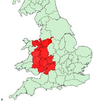
At that time, St Margarets was located within the Welsh Marches … an area along the border between England and Wales that was ruled by Marcher lordships under their own law, and independent of both the English monarchy and the Principality of Wales. The lands were exempt from royal taxation and the Lords possessed rights which elsewhere were reserved for the crown, such as creating forests, markets and boroughs. It was a wild frontier society studded with hundreds of small castles from the early years of Norman rule. Even today, the area boasts Britain's highest concentration of motte-and-bailey castles.
In 1542 or 1543 (a confusion caused by New Year's Day falling on 25 March), Henry VIII signed the second of The Laws in Wales Acts:
An Acte for certaine Ordinaunces in the Kinges Majesties Domynion and Principalitie of Wales (34 and 35 Henry VIII c. 26), was passed in 1543 in the 2nd session of Henry VIII's 8th Parliament, which began on 22 January 1542/3
The acts annexed the Principality of Wales and the feudal states of the Welsh Marches to the Kingdom of England to create a single state and legal jurisdiction.
The new law established five Welsh counties (Monmouthshire, Brecknockshire, Radnorshire, Montgomeryshire and Denbighshire), and annexed the remaining area to English counties along the border. Herefordshire added Ewyas, one of the Marcher lordships that was bounded by the Black Mountains in the west, Graig Syfyrddin in the south, the line of the Golden Valley in the east, and Vagar Hill and Cefn Hill to the north.
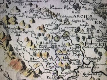
The earliest maps of the recently-expanded County of Herefordshire (based on Saxton’s map of 1577) show the parish of St Margarets at its centre.
St Margarets has its own Common as did many settlements in medieval times. Most of these were lost after the passing of the Enclosure Act in 1773 during the reign of George III. This act created a law that enabled enclosure of land and removal of the access rights of commoners, and is still in force today. There are currently 8000 registered commons in England, but the overall extent of common land is now considerably less than the hundreds of square miles that existed up until the 17th century.
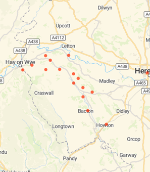
The common in St Margarets survived as a very small residual parcel of land, although still large enough for a crash landing on Christmas Day 1944 of a B24 Liberator Bomber of the United States Army Air Force. The remains of the plane were strewn over a large area of the common with the fuselage resting on the track to Lower House Farm. The nose section carried the name Bold Venture III. The plane was one of seven Liberators of 788 Squadron that were part of a bombing mission over Germany, taking flak that damaged its rudder and one of the engines. The pilot, co-pilot, radio operator and engineer bailed out over Germany and when the rest of the crew discovered to their surprise that they were alone in the plane, they too bailed out over France. Just before this they set the auto pilot that then flew the empty aircraft over Belgium, the Channel and the full width of England before running out of fuel and crashing in St Margarets. All of the crew survived their escape by parachute, although the first to bail out became POWs. Small fragments of the plane can still be found on the common, other relics are on display at the Air Training Corps Museum in Abergavenny.
The Population of St Margarets
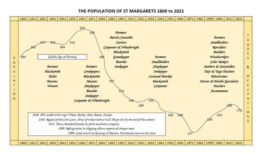
One of the first formal records of the population of St Margarets was in A Topographical Dictionary of England by Samuel Lewis, first printed in 1831. This listed the 1821 census number of 317 inhabitants. By 1851 the population was static at 316 over 74 inhabited houses. That year Lascelles listed ten people with professions - one blacksmith, one tailor, two masons and six farmers – leaving around 250 residents who lacked a formal trade or named property. No doubt a significant number were farmhands and labourers living in Cob Houses … small one or two-roomed dwellings with a thatched roof … that would have lasted perhaps 20 to 30 years. The population in 1858 was the same, but Kellys listed nine farmers, one tailor, just one mason and the Reverend Morgan Jones.
The population peaked in 1861 at 343, before gradually dropping to 339 in 1871 and 286 in 1881. This last number consisted of 72 families or separate occupiers in 68 inhabited properties. The population in 1885 was the same with thirteen farmers, the mason and the blacksmith, but now with a shopkeeper, butcher, and landlord. The Reverend was Frederick Trefusis Wybrow BA of Trinity College, Dublin. Jakeman and Carver in 1890 recorded 26 farmers, a parish constable, but also two carriers that went to and from Hereford on Wednesdays and Saturdays … market days.
The first part of this century had been the ‘Golden Age of English Farming’. Rural landowners were the wealthiest class in the wealthiest nation, but by the end of the century farming was no longer as prosperous and the landed gentry could no longer boast about their vast acres of productive agriculture with grain acreage dropping from nearly 10 million to just over 7 million acres by 1900. The repeal of the Corn Laws (admitting cheaper foreign imports from the expanding British Empire) led to the cheapest corn prices in a century with wheat reduced to £3.80 per ton in 1894 from its £8.80 per ton in 1875. In 1871, Henry Bamford and his son, Samuel, founded a farm machinery and engine company that streamlined farming practices by greatly improving ploughs, rakes, harvesters and rollers. This company rode the crest of a wave for a century and its legacy continues today. The development of refrigeration by the 1890s allowed imports of cheaper meat and fruit produce from as far away as New Zealand. By the end of the century, the cheap corn prices, cheaper meat, new farming technologies and improvements in shipping had driven farm labourers from agriculture into any other employment available, often in the towns.
In 1840, St Margarets and surrounding areas were about 60% grazing and 40% arable. The grazing would have been for Ryeland sheep, known for their fine wool which was extensively used by the English cloth industry. By the end of the century, the poorer lands had reverted to grazing and rough pasture, with sheep breeds changing in order to feed rather than clothe an ever-growing urban population.
The population had dropped to 213 by the turn of the that century, and continued to fall over the next 100 years. By 1911 the population was 198, by 1921 it was 189, by 1951 it had dropped to 160, and was at its lowest at just 127 in 1971, before rising to 150 at the turn of the last century. The population has now stabilised at around 175, but with much changed professions that reflect today’s world.
Ref: rs_stm_0187