
Held at: | Private Collection |
Reference: | gc |
Source: | Tithe Map in Herefordshire Record Office |
Title: | Gweirlody [Gwyrlodydd] Farm from Tithe Map |
Place name: | Newton |
Date: | 1844 |
Description:
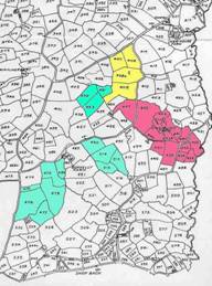
Gweirlody Farm has an interesting history. It is not ‘ring fenced’ in the sense of being one continuous block of land, but a series of separate holdings probably acquired and put together in the second half of the eighteenth century by one Walter Marsh.
At the time of the Newton Tithe Map (1844) it was owned and occupied by Thomas Sanders. In total it was about 151 acres and existed in 5 separate blocks of land
|
base map c g gwatkin Yellow – Copyhold land added to farm |
Observations:
Seach for ‘Gwyrlodydd’ for further information on this farm
Ref: gc_nwt_2004