
Held at: | Private Collection |
Reference: | RS |
Source: | www.rwpt.net/docsforweb/Final Report Mar05.doc |
Title: | Turnastone Court Farm Historic Landscape Conservation Plan |
Place name: | Golden Valley |
Date: | 2005 |
Description:
Introductory Note:
The research paper below has been written by David Lovelace in connection with the acquisition of Turnastone Court Farm by the Countryside Restoration Trust. It is published here with the author’s kind permission.
Ewyas Lacy Study Group
Turnastone Court Farm Historic Landscape Conservation Plan
Final Report. March 2005
Prepared by David Lovelace
Contents:
| Section | Page | |||||||||||||||||||
| 1 | Introduction and acknowledgements | 2 | ||||||||||||||||||
| 2 | History | 3 | ||||||||||||||||||
| |
| | ||||||||||||||||||
| 3 | Grasslands of Turnastone Court Farm | 17 | ||||||||||||||||||
| 4 | Invertebrates | 18 | ||||||||||||||||||
| 5 | Hedgerows | 19 | ||||||||||||||||||
| 6 | Woodland , wood pasture and field trees | 21 | ||||||||||||||||||
| 7 | Recommendations | 22 | ||||||||||||||||||
| 8 | Further work on the history of Turnastone and Dore Valley | 24 | ||||||||||||||||||
| 9 | Future Development of Turnastone Court | 25 | ||||||||||||||||||
| 10 | Details and costings of proposed capital works | 26 | ||||||||||||||||||
|
|
|
| ||||||||||||||||||
| 11 | Revenue options in CSS and Higher Level Stewardship | 34 | ||||||||||||||||||
| Appendix 1 Botanical list for Turnastone Court Farm meadows | 36 | |||||||||||||||||||
| Appendix 2 Moth and Butterfly records | 44 | |||||||||||||||||||
| Appendix 3 Birds recorded 2003 and 2004 | 48 | |||||||||||||||||||
| Appendix 4 Mammals | 50 | |||||||||||||||||||
| Figure 1 | Agricultural returns for Dore valley parishes 1901 to 1971 | 15 |
| Table 1 | Farm holdings and livestock densities | 16 |
| Figure 2 | Tree and shrub species composition of the hedges | 20 |
Turnastone Court Farm Historic Landscape Conservation Plan
Final Report. March 2005
1. Introduction and acknowledgements
The Historic Landscape Conservation Plan for the 250 acre Turnastone Court Farm was commissioned by the Countryside Restoration Trust (CRT) which purchased the farm in 2003, the objective of which in the first instance was the protection of the farm’s integrity. The CRT wishes to determine the historic, cultural and ecological characteristics of the farm so they can be interpreted, maintained, enhanced or restored. These assets have been created by many centuries of farming and only as a successful working farm can they be sustained and restored in the long term.
This report draws upon the work of those who have come together to draw out the essential historical, ecological and landscape factors that make Turnastone Court farm a special place. This report is to be read in conjunction with the following:
¨ Turnastone Court , Herefordshire, Survey Report by English Heritage. October 2004.
¨ Historical Landscape Management Plan July 2004 second draft by Peter and Cathy Stearne, Green Mark International (GMI).
¨ Turnastone Court Walkover Survey. July 2004 by Archenfield Archaeology
¨ Building Recording of the Farm Buildings at Turnastone Court July 2004 by Archenfield Archaeology
¨ Botanical Survey Report of the Grasslands of Turnastone Court by Alan Foulds
Many people to have contributed to this effort which is part of a longer journey of exploration, interpretation and appreciation of the Dore Valley countryside of which Turnastone Court farm is but a part. Thanks therefore to the Countryside Restoration Trust for saving this farm by outright purchase, a enormous commitment of capital, human energy and trust. To Robert and Chrissy Fraser, the farm’s tenants, who have patiently put up with the presence of many people surveying and studying the land. To members of the Golden Valley History Group who originally highlighted the importance of the farm, who have been researching the history of the Dore valley and its connections with the famous Rowland Vaughan over a number years. To Ian Hart whose personal energy and commitment was crucial to securing Turnastone Court farm and who has continued to supply species data and historical information. To Kathy and Peter Stearne our consultants on the water meadows who are national experts on their history and practical management, Kathy being England’s only female ‘drowner’. To Hugh Sherlock our archaeologist and his team at Archenfield Archaeology, to Neil Rimmington of Herefordshire Archaeology, to English Heritage who gave Turnastone Court a high priority to deploy their surveying resources and experience . To Alan Foulds, Rebecca Collins, Steve Coney and Jeff Rush for their reports on the grassland, mammals, birds and moths respectively.
DEFRA field numbers image page 9 and hedgerow numbering image page 10.
2. History
2.1 Medieval Period
The Dore valley was near the western boundary of Archenfield, the semi-autonomous former Welsh province of Ergyng[1] believed to have originated from the Romano-British kingdom of Ariconium. Archenfield’s strategic location at the time of the conquest may explain why Domesday descriptions of its manors are even more terse than usual. Turnastone appears not to be mentioned in the Herefordshire Domesday survey unlike the neighbouring manors of Chanstone (Elnodestone, 3 hides[2] ) and Poston (Poscetenetune, 2 hides). The oddly named manor of Wlvetone (2 hides, waste) has been considered[3] a candidate for Turnastone but the most recent edition of Herefordshire Domesday[4] places it near Lyonshall (a village 20km north of Turnastone near Kington). This is almost certainly a confusion with the nearby, and now deserted, settlement of the same name, a sub-manor of Peterchurch at SO356391. Both are historically spelt ‘Linhales’.
Examinations of Inquisitions Post Mortem (IPMs) and other surveys for the 13th and 14th centuries reveal Turnastone as a small active manor with a continuity of possession by the Dansey family.
In 1250 ‘Richard de Anesy alias Danaseye’ held ‘Turneyston’ manor ‘with Linhales pertaining thereto’. The field at SO361389 named ‘Crackadansey’ appears on the 1840 tithe apportionment 500m east of Lyonshall. De Anesy held these manors from Roger de Chandos to whom he owed the following service: “When there shall be a war with Wales, supply 2 footmen, one with a lance and the other with a bow and arrows for 40 days at Snodhull”. Snodhill castle is 6km up the Dore valley from Turnastone. In 1252 there was a dispute between Walter Ragun (whose family was associated with Chanstone) and Walter of Kingston about the possession of a holding in Turnaston[5] . The ‘Book of Fees’ provides that first known mention of land in Turnastone recording that its then sub-tenant Roger Ragun was evicted from half of hide of land there (about 20 hectares). This entry is dated c1250.
In 1315 an IPM of ‘Richard son of Richard Dansy’ listed the manors of ‘Turneston and Lynhales’: which recorded a messuage, 80a arable, 2a meadow, a watermill, 3a of underwood and 23s rent (from sub tenants) held from Roger de Chandos with service of ½ knights fee.
In 1322 Turnastone is listed as one of the Herefordshire manors held by Roger Mortimer of Chirk, uncle to the more famous Roger Mortimer of Wigmore[6] . In this year both Mortimers were imprisoned in the Tower of London their estates having been seized and assessed by the exchequer. Translation[7] of the original survey dated 1322 (PRO SC6/1145) shows that Turnastone had 3 acres of meadow, 1 acre of pasture, 50 acres of arable let to tenants[8] , 20 acres of pasture on fallow land, 3s from a water mill and 2s 12d from the fruit and grazing of orchards. Pasture often appears to occupy little or no land in surveys of this period. The contemporary survey of Mortimer’s Wigmore estates in reference (8) reveals that this may be due to ancient grazing rights on nearby hill and marginal land so does not appear as direct income to the lord. This may well be the case for the Dore valley manors (see discussion regarding wood pasture 6.1 below).
The 1348 IPM of Richard Dansey includes the manor of Turnastone (on its own this time) with a messuage, 100 acres land, 3 acres of meadow, 1 acre of wood and 20s rent. The Dansey family also owned two manors in Wiltshire where a Richard “de Daunteseye” is recorded as supplying the crown with wool from those manors (Calendar of Charter Rolls 1341). We know that the wool trade was a lucrative part of the rural economy at this time and wool from the Dore valley was highly prized. It was an important part of the income of Dore Abbey (6km down the valley) which controlled large areas of sheep grazing through its granges (e.g. nearby Morehampton) and extensive areas of surrounding upland pasture[9] . It is thus likely that pasture in Dore valley granges and other manors such as Turnastone was producing wool for tenants such as the Danseys.
Walter Dansey’s IPM of 1370 included “Turneston and Cheyneston (Chanstone)”: a messuage and 2 carucates (approximately 80 hectares) of land held from Thomas Chandos lord of Snodhull and rent of 40s a year from his tenants. At Chanstone 20 acres of land were held from John Ragoun. Dansey’s sisters were his heirs, so with no male inheritors the Dansey name ceases to be further associated with Turnastone although they remain at Kingstone about 7 km to the east.
40 years later in 1411[10] there is grant of the charter of “the manors of Puston and Turneyeston” to John ap Harry and his wife Elizabeth. One of the witnesses includes Thomas Dansey of Kingstone. This is probably the first documentary reference to the ap Harry family’s association with Poston and Turnastone. John ap Harry[11] ’s descendants continued to hold Poston manor including Turnastone Manor which includes that part of what is now Turnastone Court Farm in Turnastone Parish until 1635.
2.2 The manor and lands of Turnastone
The land of the ‘manor of Turnastone’ was distinct from the ‘lands of Turnastone’ which were left by Miles ap Harry the grandson of John ap Harry’s younger brother Gruffydd . Miles ap Harry died in 1488 leaving a large estate including “my lands and tenements in the fees of Turnastone and Vowchurch”. Miles’s great grandson Symond ap Harry died c1574 and left “my mansion house & lands in Vowchurch, Turnastone, St Margaret’s & Bacton” to his daughter Jane and son-in-law Griffith Jones. The mansion house in question was ‘The Moor’ Vowchurch which was later renamed ‘Whitehouse’ around 1600. So it is that these ‘lands in Turnastone’ are probably those in Turnastone parish which became part the Whitehouse estate, and what are now the land of Dolward and Cothill farms. The field ownership details given in the 1840 tithe survey preserved this separation of ownership as all the fields of the present day Turnastone Court Farm in Turnastone parish[12] were part of Poston Manor. Documents subsequent to the 15th century, which referred to the ‘manor of Poston’ or land therein, therefore included the smaller and, henceforth subsumed, manor of Turnastone.
The present day Turnastone Court Farm occupies the land of this manor of Turnastone but not the ‘lands of Turnastone’. In 1840 it was farmed by John Probert and included, as now, Weeths Meadow and Weeths Orles in Vowchurch even though they were in different ownership (Newton Dickinson, the principle land owner in Vowchurch and Turnastone including Chanstone farm, Chanstone Mill, Sherger farm, Poston farm, Poston Mill and Hill Farm). The lands of present day Turnastone Court farm in Turnastone parish were owned by Dame Eliza Gratwiche Boughton.
2.3 Elizabethan Period and the value of aftermath grazing.
In September 1587 James Parry (4x great grandson of the above John ap Harry), from a debtors’ prison, obtains a writ to remove his own wife Joan and all her tenants from Poston so that he might benefit from the revenue. The writ was revoked early the following year leaving the tenants to claim damages for loss of access to their agreement land from late summer to the new year which of course included the aftermath grass keep. The chancery depositions[13] of witness statements give an insight into Elizabethan farming at Poston and Turnastone.
Thomas Phee aged 48 and yeoman of Peterchurch was one of Joan Parry’s agents (it was customary for witness statements to be in the third person): “all her tenants in his knowledge were likewise expulsed & lost their later math grass & profits of the mill of Poston and further he says that the said Mrs Parry left behind her in the barn of Poston at the time of her expulsion about five bushels of oats, two loads of hay and certain loads of straw the which one Watkyn Morgan servant to the said James Parry took to his master’s use and further where Mrs Parry had set certain pastures to one Mr. Willyson about the time of her expulsion the said sheriff’s men finding the cattle of the said Mr. Willyson grazing upon the said pasture drove the same cattle & impounded them in this deponents fold”. (Spelling is changed to modern form.)
Griffith Jones of Monnington labourer of 30 years: “the then sheriff of the county of Herefordshire by virtue of such a writ shortly after Michelmas in the 29th year of the Queen’s reign did expulse the said Mrs Parry out of the said Manor of Poston & Tregoydyvor & that she & all her tenants lost the later math of Turnastones Meadows and other commodities they might have had if they might have enjoyed the premises accordingly for the whole year…”. Turnastone Meadow was the long meadow bordering the River Dore just north of Turnastone church (SO356368) on the 1840 tithe map. Since these hedges appear recent “Turnastones Meadows” in Elizabeth’s time may have referred to all the meadow land north of the church between the Dore and Trench Royal.
The value of the aftermath grazing along the Dore valley is explained by Walter Daunce, Yeoman, of Madley “… all her tenants were expulsed and lost their later math, grass and pasture growing upon the premises the later part of the said year and he says that he took that year the pasture of the Brick Close (SO353371 and next to Turnerstone’s Meadows) and Crabbe Meadow of Mrs Parry for that year for £? [parchment is damaged otherwise we would have a value per acre] rent for himself and his friends and they enjoyed the same the Whitsun week and they had no more grazing there upon the Crabbe Meadow but the Whitsun week only and for the Brick Close he thinks that Mr Willyson being his co-partner enjoyed the same a fortnight long and further this witness says that they spared the same pastures for a second spring by reason thereof there was upon the same pasture as good grass being a second spring as was at the first but before this witness and his co-partners could have the benefit of the said second spring where upon they detained from Mrs Parry some of the rent..”
Details of the physical act of removal were graphically described by James Prosser of Arcteston a 29 year old labourer; “…that Richard Bridges and Anthony Burne esquires (about one day before the said sheriff came to Poston to remove Mrs Parry) coming thither to Poston they came into the barn of Poston where this witness was threshing oats for Mrs Parry, and turned him out of the barn forbidding him to thresh there any more and this witness went and told his mistress thereof, who caused him to go into the barn again to thresh and to shoot the doors fast upon him at which time one Watkyn Morgan, James Parry’s man, sent for Bridges and Burne from the house of Robert Vaughan esquire where they were at dinner to come again to expulse this witness out of the barn who came and sent he thither and Watkyn Morgan breaking open the doors before them did let them in to this witness who was then and there by them beaten and the said Bridges with a wan that he had in his hand gave him such a blow upon his head that there remained the print of it a fortnight after. And throwing the corn that he had threshed from the floor to the moat expulsed this witness…”.
The main conclusions from this document concerning the lands at Turnastone in the years just before Rowland Vaughan had control of Poston and Turnastone are:
(1) Aftermath grazing on meadows along the Dore was considered a valuable commodity and was claimed to be as good as the first seasons growth. Tenants were prepared to come some distance to have the tenancy of the fields and to pasture their stock (e.g. Monnington on the north side of the river Wye).
(2) Land at Poston (including, of course, the manor of Turnastone) was let on a year by year basis, the tenants being a wide variety of people from yeomen to labourers and this seems to have been a well established practice and part of the local farming scene.
(3) There is no mention of water management.
The importance of the conclusions (1) and (2) relates to the question of what were the incentives for capital works to improve productivity on the land of the Dore valley (at least the Poston/Turnastone part of it) that was already sufficiently productive to attract a wide range of tenants.
As to (3) it may be that some form of water management of the meadows was such common practice so that it was not considered worthy of comment (see GMI 2004). A century later meadow land at Poston manor was still worth 4 times per acre more than arable (see 2.5 below) the same ratio as in the 14th century (see footnote 8).
However such a violent ‘take over’ of an estate, which included the physical ejection or threat to tenants and livestock, might also have interrupted the essential work of maintaining any system of water management either directly or because there ceased to be an incentive by the ejected beneficiaries. One may have excepted some comment from the witnesses about this (there are over 10 witnesses and their statements fill over 7 sides of parchment).
2.4 Rowland Vaughan, ‘His Booke’ and the origin of earth works at Turnastone.
Rowland Vaughan published his famous book “Most Approved and Long Experienced Water Workes” in honour of the Earl of Pembroke in 1610 and is the first published account in English concerning the science of water meadows. It is a delightful, detailed but incoherent account of the extensive water engineering operations Vaughan claims to have constructed in the Dore valley which includes the ‘floating’ of meadows and the transport of materials by barge. The book also includes details of a large “commonwealth” of artisans which Vaughan says he established in the Dore valley. ‘His Booke’ has intrigued and exasperated historians ever since its re-publication in 1879. While it is generally acknowledged that his “Commonwealth” was fantasy[14] the technical detail Vaughan gives about the water meadows cannot be lightly dismissed.
No document other than ‘His Booke’ has yet been found which indicates major agricultural capital or maintenance works at this time in the Dore valley nor mention of water meadows or their management. In addition to material in the Hereford Records Office we have looked at the available legal records[15] involving Rowland Vaughan lodged at the Public Records Office as well as the archives of the Duke of Beaufort whose ancestor bought the Poston Estate in the 1630’s and to which documents he was kindly granted access.
This is by no means an exhaustive search and there remain some sources yet to be accessed including (a) documents concerning the Vaughan family at the National Library of Wales, (b) a collection of documents in the Hereford Records Office (H30) including deeds for Turnastone Court Farm 1623–1733 which requires the permission of Major D. Davenport for access so far denied to the CRT and (c) letters and papers of Lord Pembroke to whom Vaughan’s book was dedicated.
Vaughan acquired Newcourt (3 km down the valley from Turnastone at SO372337) on his marriage[16] to Elizabeth Vaughan in c1584 but does not appear to have entered the Whitehouse estate (and with it the ‘lands of Turnastone’) until 1603 at the earliest. The earliest document describing Vaughan as ‘of Whitehouse’ is 1607 which is also the year John Parry conveyed, or mortgaged to him, Poston manor and with it most of the lands of what is now Turnastone Court farm[17] . A document of 1607 detailing the tithes from Turnastone (HRO F37/8) refers to “a certain parcel of lands of Rowland Vaughan Esq. within the parish of Turnastone lying between a certain field of John Parry and an orchard of one Ancham Powell”. This is just 3 years before the publication of his book in 1610. Brian Smith of the Golden Valley Studies Group considers the possibility that the experiments and works on water meadow systems described in the first part of Vaughan’s book relate to land at Newcourt during 1585 – 1604. Vaughan claims he wasted money 1585-95 due to ‘an incompetent carpenter’ but he was also running into debt owing to various lawsuits.
When he possessed Whitehouse from 1603 or little later he had access to the ‘lands of Turnastone’ and the Slough brook valley west, and upstream of, Poston/Turnastone manor lands where he could have embarked upon more ambitious works. He appears to have controlled the Poston/Turnastone manor lands from 1607, but by this year time was running out for him to have done major works here as described in his book published in 1610. There remains the question of the incentive for a major capital works programme on lands which already had a healthy grassland economy as indicated by the 1589 depositions above. Rowland Vaughan claimed dramatic increases of several 100 percent in rental value as a result of his water meadow works but it is difficult to envisage the typical tenants of the area actually paying these increases. By 1615 Vaughan was incapacitated by debts and by the early 1620’s Whitehouse had reverted to the original branch of the ap Harry family in the person of Epiphan Howorth by way of his marriage to Blanche the granddaughter and heiress of Symond ap Harry above.
The dyke transecting Turnastone Court farm parallel to the Dore is generally referred to as the Trench Royal after Rowland Vaughan’s book where it is described as acting as the main carrier for his water meadow system and also as a canal for moving materials. As a feature it almost certainly predates Rowland Vaughan since part of it follows a parish boundary (SO346377) and it becomes a road in various places through well established settlements. Other suggestions for its origin have included a Roman road and a means for flood alleviation for settlements on the valley floor. Another curiosity is the way that it appears to stop at Chanstone Court Farm. A deed of 1714[18] describes “a lane leading from Turnastone to Chauston” and the 1840 tithe map for Vowchurch shows that the line of the trench royal as a lane from Turnastone to Chanstone farm. They are likely to be the same lane. Close inspection of the original map (see image page 5) shows the water course along the trench royal diverted at right angles as it flows along the Weeths meadows and as a path from that point to Chanstone Farm.
Whatever the origin and fate of the trench royal the numerous sluices and other in-stream structures in and beyond Turnastone Court are testament to wide use of water control systems. This included the diversion of the Slough brook, the extensive network of channels plotted by Miss L.F.P Wood (daughter of Arthur Wood) in 1943[19] , subsequently by a group under the direction of Rosamund Skelton (1982-3) and most recently by the Golden Valley Studies Group. Writing about Rowland Vaughan and his water works in 1936, Mr. Gavin Robinson stated that “some of these trenches and sluices have been used within living memory”[20] . In 1958 Arthur Wood stated that “several of the hillside irrigation courses are clearly visible” and that “In the meadows below Whitehouse exists what is traditionally the dock at which boats for transport of goods to Newcourt were loaded and floated by a deep trench to connect with the straightened Slough brook, and so to the river Dore below Chanstone Court Farm”. This remains of this ‘dock’ may be the irregular shaped pond shown on the 1840 Vowchurch tithe map (see image page 5), part of whose remains may be the wet NW corner of Weeths Orls (35223589). The link to the Slough may have been what is now the wide shallow channel along the northern boundary of Weeths Orls although it takes a good imagination to envisage barges cruising down it to Chanstone!
The natural streams which predate their diversion are evident in the landscape and as ‘ghosts’ in fields. The sinuous channel through Weeths Meadow evident in the 1971 low sun angle aerial photograph clearly continued into the next field on down the valley (see image page 6, red arrows). The ghost of a former channel can also be seen in the adjacent field to the north (black arrows). The sinuous hedgerow bordering Weeths Meadow appears to end in the Dore suggesting a meandering stream now dry but continuing to retain the function of a boundary (blue arrows).
While Turnastone Court Farm remains one of the least altered by the 20th century, remains of in-stream structures, channels and associated topography occur on farms throughout the Dore valley. A coherent picture of water management, its relation to land use and local industry is only likely to emerge with a study of the valley as a whole. Other questions concerning Turnastone Court include the possibility of it being at the core of a shrunken medieval settlement and whether the earthworks of the Weeths meadow overlay an earlier associated field system.
The detailed topographic survey of the lower meadows carried out by English Heritage (EH) shows a complex of earthwork features and the GMI report reviews the possible meanings on a field by field basis. The elevation data from the EH survey is helpful in showing the precise distributions of levels and lends some weight to the idea that the Weeths Meadow may have originated as a field system see image pages 23 – 26. Time, erosion, siltation, not to mention the possibility of ploughing during the Napoleonic era and WWI makes it difficult to see how these meadows may have operated as a water meadow system. On the subject of ploughing, one of the meadows recommended for possible catchwork restoration by GMI (Lower Cross Field, now number 2781) was ploughed under direction of the War Agricultural Executive Committee in 1941. Further investigation, for example, soil stratification, pH and geophysical survey may well reveal more information. A recent survey[21] into the fields adjacent to the farm buildings using two Caesium magnetometers in a gradiometer configuration has shown up channels in field 9437.
2.5 Poston and Turnastone manors from Stuart times to the 20th century
The Parry family continued to own Poston manor until c1640 when it was sold by James and Mary Parry to the Marquis of Worcester (made 1st Duke of Beaufort in 1682). During the civil war Poston was sequestered[22] by Cromwell’s parliament and after the restoration was leased to James Parry who was living at Wellbrook, Peterchurch in 1661. In 1673 the lessee at Poston was one Nicholas Philpott (d.1681), who also held lands at Turnastone and is buried at Turnastone.
In 1699 an estimate was made as to the yearly value of the farmland of Poston manor[23] . Although this was not a field by field survey, the valuation distinguished between meadow, pasture, rough pasture and arable and is set out in the table below:
| Land use and estimated value of Poston manor farmland 1699 | |||||
| Farmland type | acres | % by area | mean value per acre | Value per type | % by value |
| Meadow | 91 | 19.7 | 19s 2d | £87- 0-0 | 53.6 |
| Pasture | 32 | 6.8 | 11s 4d | £17-18-6 | 11.0 |
| Arable | 116 | 25.0 | 4s 9d | £27- 6-3 | 16.8 |
| Rough ground | 225 | 48.5 | 2s 8p | £30- 1-6 | 18.5 |
| Total | 463 |
|
| £162- 6-3 |
|
| Note: Table excludes the orchards (value £10 but area not given) and Poston mill valued at £10. | |||||
The main point here is that although a fifth of the farmland is meadow it contributes over half the value of the manor. The 116 acres of arable included 47 of fallow and value of the 225 acres of rough pasture varied from 2s/acre (112 acres) to 4s/acre (40 acres) and would have included extensive wood pasture on Poston and Turnastone hill. Enclosed woodland is excluded from this table as it would have been ‘in hand’.
Poston was eventually leased in c1705 to the Duke’s fifth son, Lord Arthur Somerset whose granddaughter married a Shuckburgh Boughton. It then descended c1756 to Sir Edward Boughton (d.1794) who left Poston to his daughter Eliza who was still the owner at the time of 1840 tithe survey as Dame Eliza Gratwiche Boughton. Their only child Frederica married Thomas Robinson in 1824. Poston then passed to their grandchild Harriet who married Edward Robinson who died in 1908 after losing money invested in the Golden Valley Railway. In 1879 Turnastone Court farm was let to John & Selina Probert presumably just after the building of the present farmhouse. Parts of the Poston Estate were also sold at this time and after the death of Edward Robinson, Turnastone Court Farm was purchased in 1912 by William Watkins who had entered the Farm as Robinson’s tenant soon after marrying his first cousin Elizabeth Annie Watkins in 1902. Turnastone Court Farm was Lot 1.[24]
2.6 Turnastone Court lands and the agricultural context 1800 - 1971
There are a number of references to ditches, draining and flooding at Turnastone around the turn of the 19th century. An agreement[25] for the lease of Whitehouse estate in 1796 includes expenditure by its owner Mr. Downes “..in clearing draining, fencing & dividing the premises & erecting lime kilns, floodgates, banks or stanks” the tenant Mr. Phillips was to pay 2% of the capital costs. In October 1800 Mr. Downes complained to William Davies, manager of the Poston estate: “you promised me long ago to raise & extend the lower wear in the lane behind Poston House so as to prevent the water as much as possible from running down to Turnastone & driving the inhabitants out of their houses as well as blowing up the road & also to make the upper wear safe so that the water may be turned off the road into the new course down the meadow but I am sorry to say there is nothing done at either place..”[26] .
Clearly, there were active water management features on both the Whitehouse estate and Poston lands in Turnastone including “the new course down the meadow”. Where these are or what were their functions is unclear. Several fields (three at Poston and one at Chanstone) are described as “water meadows” in late Victorian leases.
John Clark and John Duncombe in their “General Views” of Agriculture in Herefordshire at the turn of the 18th century mention water meadows only fleetingly. Documentary references to water meadows in Herefordshire at any time are sparce.
During the Napoleonic wars of the 1800’s, a period of shortage and high cereal prices, some 60% of the Herefordshire farmland was reported to be under arable and by the time of the Tithe surveys of the 1840’s this figure was 46%. For land at Turnastone Court Farm, the tithe survey shows 9 out of 18 fields (of those over 1 ha) in the parish of Turnastone were classed as arable in 1840. See image page 2 for land use. This proportion exceeds any subsequent time including WWII when Mr. Watkins was ordered to plough 10.1 hectares of grassland (see below).
The latter part of the Victorian period saw a general depression in farming, especially arable. In Herefordshire 21,000 hectares of arable (10% of the county) were be put down to grass between 1875 and 1900. The Herefordshire MP Thomas Duckham reported[27] that the Depression had “not been so marked in the county because of the great variety of crops”. 24% of the farmland of Turnastone parish, comprising the three farms of Dolward, Cothill and Turnastone Court farm[28] , was still arable in 1901. This included 40 acres of wheat, 21 of Barley and 45 of oats. Grassland occupied 74%, 17% of which were new leys and orchard 2%. This was typical of the farming of the central Dore valley as shown by the analysis of the agricultural census figures (PRO MAF/68) for the parishes of Abbey Dore, Peterchurch, Turnastone and Vowchurch. Figure 1 gives the general picture of farmland use 1910 to 1971 for these parishes derived from this data.
During WWI, compulsory ploughing orders were issued followed by the first cereal subsidies in 1917 which guaranteed prices for Wheat and Oats. Between 1914 and 1919 12,500 hectares of Herefordshire grassland was ploughed, half the area of the arable grassed down during the late Victorian depression[29] . Unlike for WWII (see below) we do not have any documentary information as to which fields were ploughed in Turnastone during WWI but it seems probable that some were. Arable fortunes tumbled in the 1920’s/30’s and by 1938 85% of Dore valley farmland was grassland and Turnastone parish was 80%. Livestock numbers increased substantially and for Turnastone almost doubled (see table 1 & 2 and Figure 1 below for the statistics).
The Land Utilisation Survey (LUS) of Herefordshire[30] , which was conducted during 1935 and 1936, maps the distribution of arable fields at Turnastone Court farm which were more or less coincident with those of the present day. The author of the survey was well aware of Rowland Vaughan’s connection with the Golden Valley: “In the late sixteenth and early seventeenth centuries Vaughan was cultivating part of the valley and began his famous “water-works” there, but no water meadows remain now”. On the general subject of water meadows she observed that “There are no water meadows in the county now, though there were some about a generation ago near Weobley”. A reference which remains enigmatic.
The condition of Herefordshire grassland, which in 1937 exceeded 70% of all farmland, is described in a survey by the Ministry of Agriculture carried out 1939-40. This reported that only 5% of Herefordshire’s grassland was “1st or 2nd grade ryegrass”, 4% that was “Agrostis [Bents] with excess of rushes and sedges” and the 3.8% which were “Fescue pastures of mountain, open downland and lowland heath”. The majority (60%) of the grassland was “dominated by native grasses [mostly Bents] with sometimes the merest traces of Ryegrass”. The surveyors remarked of the “more elevated regions” that “much of this land is at present badly infested with rabbits, while ant-hills are a common feature of old pastures”.
During the WWII “War Agricultural Executive Committees” (WAECs) were set up with officers in each county to ensure that farms were managed as efficiently as resources allowed. WAECs had the power to order the conversion of suitable grassland to arable production and reports were made of individual farms for the year 1941. These surveys were released by the PRO after the 50 year rule in 1994. The data collected in March 1942 for the 3 farms in Turnastone including Turnastone Court farm are tabulated in table 2 below.
None of the farms had electricity at this time but they each had one Fordson tractor. Turnastone Court farm still had 11 horses (4 adult mares, 3 unbroken mares and 4 unbroken geldings). In 1940 the WEAC ordered Mr. Watkins to plough grassland 1905 map field numbers 16 (now 0178) and 17 (now 0761 ) totalling 17 acres. In 1941, field number 19 (now 2781) – adjacent to the Trench Royal - was ploughed. Turnastone Court farm buildings and farmhouse were described as “good”, the arable, pasture, fences, ditches and condition of field drainage were all “fair”. While there were no “derelict fields” nor any “heavy infestation with weeds” there was “infestation with rabbits and moles”. There appears to be no documentation for subsequent years of the war or for what fields, if any, were required to be ploughed after 1941. However the 1946 aerial photograph (image page 3) shows that the block of land comprising present days fields 0178, 2781, 1968, 4059, 2332 and 6656 was in arable at this time. (see image page 9 for their locations).
Photographs from the Watkins family archive give glimpses of the farming, landscape and livestock at Turnastone Court Farm before and after WWII. (see image pages 11 to 13)
After WWII the government introduced an ambitious and expensive programme of farmland “improvement” which is well documented. The 1946 Herefordshire Planning Survey echoed the national policy recommending, for example, “the elimination of uneconomic units of production”, “changes in the size and grouping of holdings and in field boundaries in order to make possible the use of modern agricultural science” and the expansion of ley farming to replace “the thousands of acres of inferior pasture”. A side effect of this policy was the trend to farm specialisation and the loss of what remained of the variety of local traditional produce. It is against this background that H.J. Massingham described the landscape and farming of the Golden Valley in 1952[31] which for him represented the ideal of productive farming in harmony with nature and history but which he could see was about to be destroyed by post war farming policy.
“My earliest recollection of the Golden Valley goes back nearly fifteen years and I know of no other domestic and easily accessible valley of its type that has been so little subject to change ….you see there pigs and sheep in its grassy orchards, sheep on clover stubble, fine herds of Herefords (the most gratifying sight of all), fields large and small, wheat as well as oats, root-crops as well as potatoes, beehives as well as clover-leys. Though farms are both large and small, the farming is mixed for both and so non-predatory and so stable. Stable, I mean, in the relation between man and soil, fertility and management, since the economic bias against such farming in our own time and the pressure of specialisation make such balances unnaturally precarious.”
Massingham was ahead of his time in recognising the living historical context of the farmed landscape epitomised for him in the Golden Valley with “its snugness, its fertility, its still well-stocked farmlands, its knotted string of settlements, its cluster of tumps, mottes and earthworks (there are at least fourteen tumps and remains of four castles), … its superabundance of holy wells, the variety of its churches, its wealth of Stuart craftsmanship and frequency of seventeenth century houses, its intensive cultivation in the past, its rich continuity in flocks and herds, corn and orchards, and its historical integration.” He would have applauded the Countryside Restoration Trust and its efforts on behalf of Turnastone Court Farm.
Figure 1
Agricultural returns for Dore valley parishes 1901 to 1971 farmland and grassland.
|
|
|
|
|
|
|
|
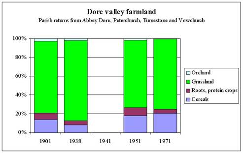
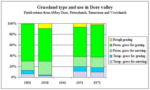

Table 1:
Farm holdings and livestock densities for Abbey Dore, Peterchurch, Turnastone and Vowchurch
| Dore parishes (AD, P, T & V) | 1901 | 1938 | 1941 | 1951 | 1971 |
| No. of farm holdings | 121 | 131 |
| 131 | 83 |
| Cattle per 1km2 of farmland | 47 | 56 |
| 67 | 84 |
| Sheep per 1km2 | 198 | 269 |
| 242 | 404 |
| Pigs per 1km2 | 9 | 19 |
| 9 | 18 |
| Horses per 1km2 | 12 | 10 |
| 3 |
|
| Turnastone parish only | 1901 | 1938 | 1941 | 1951 | 1971 |
| No. of farm holdings | 3 | 3 | 3 | 3 | 3 |
| Cattle per 1km2 of farmland | 35 | 63 | 81 | 68 | 93 |
| Sheep per 1km2 | 120 | 268 | 211 | 239 | 515 |
| Pigs per 1km2 | 3 | 16 | 10 | 4 | 7 |
| Horses per 1km2 | 10 | 14 | 11 | 3 |
|
Table 2
Figures for the WAEC 1941 survey for the three farms of Turnastone parish:
Turnastone Court Farm, Cothill and Dolward.
| Areas in hectares | Turnastone Court | Cothill | Dolward | Turnastone Parish |
| Grass ploughed 1940 & 1941 | 10.5 | 10.1 | 10.1 | 30.8 |
| Wheat | 10.9 | 13.4 | 14.6 | 38.9 |
| Barley | 3.2 | 1.4 | 2.4 | 7.1 |
| Oats | 8.1 | 6.1 | 8.1 | 22.3 |
| All cereals | 22.3 | 20.8 | 25.1 | 68.2 |
| Root and protein crops | 3.6 | 4.8 | 4.5 | 12.8 |
| All arable | 25.9 | 25.6 | 29.5 | 81.0 |
| All grass | 73.2 | 37.6 | 83.8 | 194.7 |
| Orchard | 2.4 |
| 2.4 | 4.9 |
| All farmland | 101.6 | 63.2 | 115.7 | 280.6 |
| Temp. grass for mowing | 2.8 | 4.9 | 4.0 | 11.7 |
| Temp. grass for grazing |
| 6.1 |
| 6.1 |
| Perm. grass for mowing | 29.1 | 16.2 | 20.2 | 65.6 |
| Perm. grass for grazing | 41.3 | 10.5 | 59.5 | 111.3 |
| Grassland as % farmland | 72.1 | 59.5 | 72.4 | 69.4 |
| Permanent as % of all grassland | 96.1 | 71.0 | 95.2 | 90.9 |
3. Grasslands of Turnastone Court Farm, an overview of their biodiversity.
3.1 The farm has been managed conservatively as a traditional livestock farm by the Watkins family throughout their tenure since 1902. We have a good idea of which grassland fields have remained unploughed during most of that time, which were ploughed in WWII and which more recently. The degree of species richness of the swards varies considerably throughout the farm. See ‘Botanical Survey Report for Turnastone Court’ by Alan Foulds.
3.2 The lower meadows including the possible former water meadows have a generally species-poor herb content but are mainly composed of native grasses with low levels of Rye Grass, an indicator of improvement and intensive use. This is also the case for meadows such as Lower Cross Field (2781) known to have been ploughed during WWII. It is also true for meadows such as Weeths Meadow (6717) and Long Meadow (4330) which have probably not been ploughed since the first world war or longer. One might expect a greater botanical richness on these meadows given the overall history of the farm and possible reasons include:
(1) The farm had a dairy enterprise during some of the post WWII years which may have resulted in higher stocking density and nutrient input.
(2) In the years immediately preceding the death of the last Miss Watkins Nancy 1985 artificial fertilisers may have been used.
(3) The eastern part of Weeths Meadow 6717 near the farm has been subject to poaching and eutrophication by supplementary feeding. There are significant patches of invasive weeds such as Dock and Creeping Thistle.
(4) Eutrophication by flood waters carrying recently increased silt and nutrients from catchment land use upstream.
(5) Periods of prolonged grazing without locking up for of hay and/or early hay cutting both of which favour grasses over broadleaves and reduces the seeding of meadow herbs.
(6) Changes in livestock type, for example from cattle to sheep, the latter grazing more selectively.
3.3 Grasslands on the sloping and high ground to the west have a considerably richer species content as well as a higher overall proportion of herb species and rarer grasses such as Yellow Oat Grass and Quaking Grasses. These grasslands have invertebrate interest including ant hills and Burnet moths (see image page 15) indicators of long unimproved grassland. Both are abundant in field 0831 above Ladywell Cottage which also has Fairy Flax and fine displays of Lady’s Bedstraw. Weeths Orles (4584) which runs up from Weeths Meadow to Chanstone Wood is a good example of a dry MG5 hay meadow community with Knapweed, Hay Rattle, Ox eye daisy and Common Spotted Orchid and Harebell. The most westerly field (4873 & 5779) on the farm grades into wood pasture and represents a small but significant remnant of the former ‘Turnastone Hill Wood’ mapped in the 1810’s (see map regression pages 2 to 4). This field contains woodland/wood pasture species: Primrose, Pignut, Goldilocks, Dog Violet, Greater Stitchwort and Bluebell as well as old grassland indicator species such as Adders Tongue Fern, Meadow Vetchling and Devil’s Bit Scabious. A springline (image page 18) adds further diversity with Golden Saxifrage, Brooklime, Wild Garlic, Sedges, Rushes.
Species composition of the grassland fields is listed in Appendix 1. See also image page 15. During 2004 additional meadow species continue to be observed, for example, Saxifraga granulata Meadow Saxifrage in 6717 (Weeths Meadow) and Briza media Quaking Grass in 7478 (Upper Ox Pasture). This indicates a continuing increase in grassland biodiversity throughout the farm in response to sympathetic management.
3.4 Discussion and future management
Semi-natural grassland of all types has suffered considerable decline in recent decades due to increasingly intense management, ploughing, reseeding and conversion to arable. This is especially so on the flatter land with alluvial soils where even semi-improved grassland is now quite uncommon. On sloping and higher ground unploughed grassland is more frequent but the use of artificial fertilisers and high stocking rates, particularly sheep, has reduced sward biodiversity to low levels. Typical swards of the late Victorian period are described by the Herefordshire Flora[32] of 1889 in its entry on the Green Winged Orchid (now rare old grassland indicator): “locally very abundant and common throughout the county. In hilly pastures it is particularly abundant; and, with the numerous shades of colour which its blossoms present, adds greatly to their ornament.”
Even the swards with the least species diversity on the farm are thus important while the most species-rich grasslands such as Weeth’s Orles 4584 and the Turnastone Hill fields 4873 and 5779 are gems of local biodiversity. With an area of over 200 acres, variety of soils and topography, the farm’s grassland has much potential for biodiversity gain and its size makes it ecologically robust. Being part of a traditional working farm provides a dynamic management and long term future which may be emulated by other farms.
4. Invertebrates
4.1 Butterflies and moths.
Surveys have been carried out 2003 and 2004 have recorded 20 butterfly species and 113 moths species. These are listed in appendix 2 below.
For the butterfies, noteable species include the Large Skipper and Common Blue both dependant upon areas of unimproved grassland. The Small Copper is formerly common but declining as is the Small Heath. A large population of peacock butterfly larvae was recorded this year on a nettle patch on the northern edge of field 0631. See image page 17. There are a number of moths species associated with old grassland including the Burnet Moth of which there are four thriving colonies, the Ghost Swift and the Mother Shipton. The moth species the Red Sword Grass & the Tawny Pinion are rarities in this county.
4.2 Other orders have not been studied but the ‘Robin’s Pin Cushion’ gall wasp and the ‘Bee mimic’ hover fly have been noted in passing. The Monnow project has recorded two species of caddis fly (Allogamus auricollis, Halesus radiatus) and the Damsel Fly Calopteryx virgo at the River Dore adjacent to Turnastone Court Farm.
5. Hedgerows
5.1 County context.
Herefordshire had a smaller % (<5%) of its farmland subject to Parliamentary enclosure than other Midland counties. In 1791 the county was described as “much enclosed and has been for ages past”[33] .
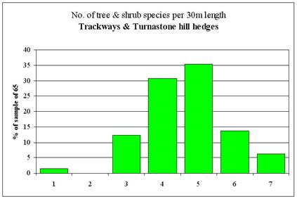
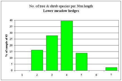
5.2 Turnastone Court Farm hedges (see image page 16 and figure 2 below)
Some hedges are recent: compare the 1840 tithe map with the Ordnance Survey 6” map of mid 1880 (image pages 2 to 3) between which dates Lower Cross Field, Upper Cross Field and Eight Acres were realigned to the present fields 2781, 0178 and 1968. Some of Turnastone parish hedges were planted under the direction of Rowland Vaughan himself. “The parson hath common in all the fields wherein his lands lyeth which fields were common and without incloses until they were inclosed by Rowland Vaughan Esq.”[34] Some hedges may have been planted along former diches, for example the western boundary of Turnastone Meadow (6282).
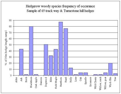
The tree and shrub species composition of hedgerows at Turnastone Court farm has been determined by sampling over a 100 30m hedge lengths throughout the farm and they fall into two distinct catagories. Those of roads, tracks, woodland edges and upper fields are quite species rich and have a composition not unlike local ancient wood while those associated with the lower meadows which are fairly species poor and with less frequency of ‘woodland type’ species. See figure 2 below.
Hedgerows of the roads, tracks and hill fields have a consistently higher number of species per 30m section 56% having 5 woody species or over whereas that figure for the lower meadows is only 15%. In terms of species composition ‘trackway and hill’ hedges have much higher frequencies of Field Maple, Dogwood, Wych Elm, Ash and Oak than lower meadow hedges.
There is considerable variation in the degree of management, heights and stock proofing of hedges on the farm. The hedge between 7560 and 7139 is a line of trees (see middle left photo image page 16), albeit with old signs of laying, and has been for many decades whereas the hedges around the arable field 4059 are closely flailed. Most of the hedges require fencing to be reliably stock proof.
5.3 Hedgerow Trees (see image page 14).
A notable feature of the farm is the many hedgerow trees some are which quite mature with a few old pollards. Most are Ash or Oak with the occasional Field Maple and one Lime. Some have been pollarded in the past but none for many decades leading to top heavy crowns and the risk of wind blow. A number of hedgerow trees are put forward for pollarding see section 10 below.
Figure 2 Tree and shrub species composition of Turnastone Court Farm hedges
|
|
|
|
|
|
|
|

6. Woodland, wood pasture and field trees
6.1 wood pasture
The amount of woodland in Herefordshire in the past has generally been over-estimated while wood pasture, a now forgotten land use, was probably more common in the Middle Ages than woodland. The pre-Tudor records for Turnastone (see 2.1 above) mention only a small acreage of woodland: just 1 acre in 1348. Studies of other estates in West Herefordshire[35] at this time show that grazed wood pasture and marginal land was an important resource often omitted from surviving records because local people had ancient customary rights to such land for which the Lord was not able to charge. It is likely that the higher ground, places such as Turnastone Hill and Poston Hill, had common rights attached to them which would have originated in pre-conquest Welsh law. Such unrecorded rights may explain the virtual absence of pasture from most manorial accounts including Domesday. There would also have been regular movement of stock from the valleys to the hills and back.
The funnel shaped field of 0149 (‘Kiln Piece’ on the tithe map) which emerges westwards up Turnastone Hill from the green lane is similar to the entrances to a number of commons in the county. This suggests that Turnastone Hill may have been an ancient woodland pasture with rights and possibly the very land enclosed by Rowland Vaughan himself according to the 1607 terrier of Turnastone Rectory lands.
A small strip of Turnastone Hill (apportionment number 52, now within the Ash plantation) remained glebe land in 1840. The Ordnance surveyors drawings of the 1810’s are the earliest map we have of Turnastone and they show all of Turnastone Hill as woodland, see image pages 7 to 8. By 1840 the eastern part of this woodland had been converted to arable and pasture but all the hill is named ‘Turnastone Hill Wood’. The tithe survey assessed tithe values according to land use and grazed land is not distinguished according whether it had trees, however the original tithe map marks an even scattering of trees over apportionment number 48, the western portion of the wood, and what are now fields 4873, 5779 and western part of 7560. By the time of c1880 6” Ordnance Survey map, which plots mature trees, the western part of 7560 had been cleared but tithe numbers 53 and 58 (Kiln Piece), defined as grassland but no trees marked on the tithe map, is well treed.
This aerial photograph shows the distribution of trees to be very similar to that of 1880 but by 1971 the southern part of the wood pasture had been grubbed. (image page 4).
The remnant of this woodpasture, field numbers 4873 and 5779, is likely to be ancient and its conservation and enhancement should be given appropriate priority. The species list for these fields is given in appendix 1 and has both woodland and meadow indicator species. The two old oak pollards (image page 14, top left) are likely to over 250 years old. There are about 30 trees per hectares marked on the 6” 1st edition OS for the western part of Turnastone Hill Wood.
6.2 The field trees of the farm are confined to the former wood pasture area and the group of old Oak and Ash trees on the knoll in field 0149 which are the remnant of the eastern extent of the original Turnastone Hill Wood as delineated in the 1810’s Ordnance Surveyors drawings.
6.3 The Ash plantation. This is a modern plantation created just before WWII (see RAF 1946 air photo image page 8) on what was arable at the time of the Tithe survey in c1840. It includes a few mature Oaks and Ashes to the north. The ground flora is poor and eutrophic with docks and nettles.
7. Recommendations (refer to section 10 capital works)
7.1 Farm buildings (see Building Survey Report by Archenfield Archaeology):
¨ Replace stone tile roof of building number 16-17 (the long barn at right angles to the road) with tiles of similar character.
¨ Rebuild the stone western gable end of building number 9 (grade II listed) which is leaning outwards and needs urgent attention.
¨ Building number 4, the threshing barn along the road side: replace white asbestos roof with the original stone or replica.
¨ The site of the original manor house as mapped in 1840 and is a few meters south of the SE corner of building number 15. Any development work which involves ground disturbance should be undertaken in the light of further archaeology survey.
¨ Building works need to be mindful of the use of the barns as bat roosts as recommended in the mammal report section 4.8 appendix 4.
7.2 Water Meadows (see GMI report)
¨ Stabilisation of structures. These are being undermined by the water flow and tree roots. Follow the recommendations in section 2.6 paragraphs “Stabilisation of structures”, “Trees and shrubs”, “Undermining of sills by water” and “Longer term objectives for structures.
¨ Restoration of irrigation. The GMI report (section 2.6 and appendix C) details advice and recommendations in respect to fields 2781 (Ross Field or Lower Cross Meadow - ploughed in WWII) and field 6717 (Weeths Meadow). Attempts to restore these fields as any form of working water meadows requires not just capital investment but on-going regular commitment of some skill. For Weeths meadow there is the issue of the neighbouring Chanstone field, currently arable, which would be affected by water level changes. While not ruling out any long term commitment to capital works along the lines suggested by GMI any such work needs to be informed by further archaeological survey, soil analysis, streamflow data and an examination of historic water management and related archaeological features on neighbouring land and Dore valley generally. The proposed Local Heritage Initiative Dore Valley History project will allow resources to be deployed to this end.
¨ Protection of the stone bridge between 6717 and 4584. GMI suggest that this bridge may not be able withstand large vehicles crossing in the long term and suggest the construction of a new bridge.
7.3 Archaeological features outside the watermeadows
¨ There many features to be seen on the land outside the lower meadow fields including remnants of ridge and furrow, banks associated with old woodland and enclosure, quarries, old trackways, channels etc. These are identified in the report of the Walkover Survey and are best preserved by maintaining existing grassland as permanent pasture or meadow. However care needs to be taken when undertaking any works involving machinery for example fencing, hedge maintainace or works which may be undertaken by contractors for example as part of the Monnow project.
¨ This has been a necessarily brief survey given the resources, so more detailed investigations will be needed (see section 10). The possibility of water channels in the higher fields should investigated.
7.4 Grassland management
¨ Increase the number grassland fields in stewardship consistent with practical stock management.
¨ Avoid the use of artificial fertilisers on non-stewardship grassland.
¨ Take steps to reduce nutrient enrichment and weed infestation in the Weeth’s meadow 6717, mainly the area towards the farm. This is best achieved by cutting and removing vegetation twice a year for a few years. Also the thistle populations of the meadows north of the church (4978, 6656, 6282) need to be controlled by topping or weed wiping.
¨ Monitor the grassland species composition by establishing a series of relocatable plots surveyed, photographed to allow a review of the effects of management after, say, 3 years.
7.5. Other aspects of the enhancement of biodiversity.
7.5.1 Invertebrates need a variety of habitat as well as pollen sources. Hedgerow management needs to ensure that flowering shrubs and early pollen generators such as male willows are not cut every year (see photo 7 image page 17). Isolated nettle patches that are not growing in extent should be tolerated as feeding areas for Peacock and Small Tortoise Shell butterfly larvae (see photo 2 image page 17)
7.5.2 Birds: Waders such as curlew which may be breeding at adjacent Poston and are likely to be adversely affected by the high crow numbers. Control measures may be needed. Pied flycatcher is known to breed locally but has not been seen at Turnastone Court. A nest box scheme centred in the ‘wood pasture’ area of 4873 and 7478 may encourage them.
7.5.3 Water courses: The quality of the main streams of the Slough and Shergar Brooks depend upon land use upstream but they would benefit from the opening up of bank vegetation for example by regular coppicing of alder, ash and willow. This is also the recommendation from the mammal report see 4.2 appendix 4. Some fencing may be necessary as recommended in 4.4 appendix 4. The Monnow project offers resources to this effect and the CRT may wish to involve them at Turnastone Court farm the following provisos: (1) such work is complementary to that undertaken within the Stewardship agreement. (2) contractors machinery does not damage any archaeological features leading to or on the banks nor of course any of the in stream artifacts.
7.6. Woodpasture, the ash plantation and hedgerow & field trees
7.6.1 Avoid over grazing the western fields 4873 and 5779 and do not use pigs which will disturb and eutrophy the ground in such a small area. Grazing should be such as to allow a balance Expand the wood pasture area to include fields 7560 and 4873 so as to approximate its early 19th century extent. Planting a scattering of trees, widely spaced, for a final average spacing of 30m or 10 per hectare, mostly Oaks from nearby trees appropriately protected and fencing to control stock to allow a balance of scrub regeneration and open grassland. Note the appearance of this area in the 1907 photograph on image page 11 and map sequence image pages 7 and 8.
7.6.2 Coppice the Ash of the plantation, retain some of the conifers as nesting sites. Enrich the regrowth with site native tree and shrub species of local provenance. Fence out stock and include the lower boundary bank (photo 3 image page 16).
7.6.3 Hedgerow and veteran trees. Retain and pollard a selection (see section 10). Dead hulks and fallen branch wood such as in image pages 14 and 18 constitute a habitat resource and should be retained unless they are an obstruction.
7.7. Hedgerows (see image page 10 for numbering system)
¨ Recommendations for hedge management are detailed in the capital works section 10 below. This involves an extensive programme of restoration. Some general observations:
¨ The relatively species poor hedges associated with the lower meadows should managed ‘tight’ to allow as much of an open aspect for the meadows as possible. This would benefit waders such as curlew.
¨ A few of the hedges which have been unmanaged for many years have become grown up and some lines of trees. These add landscape and habitat diversity and should be retained as such. For example, hedge no. 8 between 7139 and 7560 (photo middle left image page 16) is a line of trees of great character and should be retained and protected against stock. Also hedges 2, 7 and western part of 13.
8 Further work on the history of the Turnastone Court Farm and the Dore Valley
The CRT should maintain the momentum of its current Dore Valley LHI project proposal. But it is essential that it laises closely with local landowners and the Golden Valley Studies Group. An enormous amount of material has been assembled in the course of this project but the picture remains confused with question unanswered and new questions posed. Part of the problem is the necessary focus on Turnastone Court farm to the exclusion of the Dore valley context. Another is the association of Turnastone with the famous name of Rowland Vaughan which may have placed too great an emphasis upon one particular aspect of land management when the picture that may be emerging is of a more complex and multilayered story involving the totality of the Dore Valley.
9. Future Development of Turnastone Court
The open day early this year attracted well over a thousand visitors and gives some idea of the potential of Turnastone Court as a centre for rural knowledge, skills, farming best practice and a resource for locals. There are number of possibilities involving a visitors centre and/or a working depository of information about the ecology, history and farming of the Golden Valley. This would also have benefits for the local rural economy. Archive.
The CRT should investigate funding sources for such a capital project which would be eligible for Rural Enterprise Scheme funding, Heritage Lottery Fund and/or Objective 2 under the West Midland Rural Regeneration Zone.
10. Details and costings of proposed capital works
10.1 Hedgerow management, gates, pollarding hedgerow trees and planting trees for woodpasture. See map on image page 10 for numbering. Prefix R = ring fence and/or ownership boundary. Lengths in meters.
| Hedge | Year | Location | Length | Code | Description | Length | Rate/m | Rate work | Comments |
| R1 | 2005 | 4873, western boundary | 245
| HF | Remove old fence | 245 | £0.60 | £147.00 | Fence poor, restoration involves gapping up |
| HR | Hedge restoration | 180 | £5.00 | £900.00 | |||||
| FSB | Sheep fencing | 245 | £1.80 | £441.00 | |||||
| R6,R7 | 2011 | 0831, 2332, 4059, 4330 | 1210 | HR | Hedge restoration | 1210 | £5.00 | £6,050.00 | Roadside hedges, trim sides but allow growth of pleachers |
| HSL | Top binding & staking | 1210 | £2.40 | £2,904.00 | |||||
| R7 | 2005 | 4330, NE boundary | n/a | ST | Timber style | 1 | £100.00 | £100.00 | Style to road |
| R15 | 2005 | 4584, southern boundary | 260 | SC | Scrub clearance | 0.13 ha | £583.00 | £75.79 | Edge of Chanstone wood, clear encroaching scrub, fell to clear boundary bank, lay bank hedge, fence |
| HCS | Preparing hedge | 260 | £2.40 | £624.00 | |||||
| HR | Hedge restoration | 260 | £5.00 | £1,300.00 | |||||
| FSB | Sheep fencing | 260 | £1.80 | £468.00 | |||||
| R16 | 2007 | 4584, eastern boundary | 170 | HF | Remove old fence | 261 | £0.60 | £156.60 | Overgrown hedge to be laid |
| HR | Hedge restoration | 262 | £5.00 | £1,310.00 | |||||
| HSL | Top binding & staking | 263 | £2.40 | £631.20 | |||||
| FSB | Sheep fencing | 264 | £1.80 | £475.20 | |||||
| R17 | 2006 | 6717, southern boundary | 460 460 460 | HF | Remove old fence | 460 | £0.60 | £276.00 | Gappy hedge |
| HR | Hedge restoration | 180 | £5.00 | £900.00 | |||||
| FSB | Sheep fencing | 460 | £1.80 | £828.00 | |||||
|
| TS2 | Pollard | 1 | £89.00 | £89.00 | Pollard Ash at 35623597 | |||
| R25 | 2005 | 2781, northern boundary | 290 | DR | Ditch restoration | 290 | £2.90 | £841.00 | Renew ditch to confine flow to Sheargar brook |
| R26 | 2006 | 7478, 0178 northern boundary | 320 | HF | Remove old fence | 320 | £0.60 | £192.00 | Renew boundary hedge, lay, gap up and fence |
| HR | Hedge restoration | 320 | £5.00 | £1,600.00 | |||||
| 7478, 0178 northern boundary | 320 | FSB | Sheep fencing | 320 | £1.80 | £576.00 | |||
| R27 | 2006 | 4873, 5779, 7478 northern boundary | 360 | HF | Remove old fence | 360 | £0.60 | £216.00 | Renew boundary hedge, lay, gap up and fence |
| HR | Hedge restoration | 360 | £5.00 | £1,800.00 | |||||
| TS2 | Pollard | 3 | £89.00 | £267.00 | |||||
| FSB | Sheep fencing | 360 | £1.80 | £648.00 | |||||
| GR | Wooden river gate | 1 | £100.00 | £100.00 | River gate crossing Sheargar brook | ||||
| 4a | 2010 | 7478, Eastern boundary | 70 | HF | Remove old fence | 70 | £0.60 | £42.00 | Leave to grow up 5 years, lay & fence. |
| HR | Hedge restoration | 70 | £5.00 | £350.00 | |||||
| FSB | Sheep fencing | 70 | £1.80 | £126.00 | |||||
| 4b | 2006 | 7478, Eastern boundary | 90 | HF | Remove old fence | 90 | £0.60 | £54.00 | Renew fence next to wood |
| FSB | Sheep fencing | 90 | £1.80 | £162.00 | |||||
| 2 | 2005 | 7478, Southern boundary | 320 | HF | Remove old fence | 320 | £0.60 | £192.00 | Remove old fence (including from living trees), Pollard 3 willows & Field Maple, leave as tall hedge, fence north side 1.5m away from stems. |
| TS2 | Pollard | 4 | £89.00 | £356.00 | |||||
| FSB | Sheep fencing | 320 | £1.80 | £576.00 | |||||
| 8 | 2005 | 7560, 7139 boundary between | 190 | FW/B | Post and wire | 380 | £1.20 | £456.00 | Line of old trees, fence with 3 strands of barbed wire 2m either side of hedge line to discourage stock damaging root systems |
| 6 | 2005 | 7560, 0149 boundary between | 210
| HF | Remove old fence | 210 | £0.60 | £126.00 | Remove old fence renew on west side. |
| FSB | Sheep fencing | 210 | £1.80 | £378.00 | |||||
| 7 | 2005 | 0761, 0149 boundary between | 290 | HF | Remove old fence | 290 | £0.60 | £174.00 | Remove old fence renew on south side. |
| FSB | Sheep fencing | 290 | £1.80 | £522.00 | |||||
| 9 | 2006 | 7560 in middle of | 180 | TS1 | Pollard | 6 | £43.00 | £258.00 | Gappy line of hawthorns, pollard larger ones, gap up, double fence 2m either side of hedge line. New gate. |
| HR | Hedge restoration | 140 | £5.00 | £700.00 | |||||
| FSB | New fencing | 360 | £1.80 | £648.00 | |||||
| GF | Wooden field gate | 1 | £150.00 | £150.00 |
| 13 | 2008 | 2332, west boundary | 205 | HF | Remove old fence | 205 | £0.60 | £123.00 | Remove old fence, cut area of scrub in west corner, re-fence south side including scrub regen as habitat, leave west 2/3 of hedge to grow up for diversity, lay east 1/3 after pleachers grown up. |
| HR | Hedge restoration | 60 | £5.00 | £300.00 | |||||
| HSL | Top binding & staking | 60 | £2.40 | £144.00 | |||||
| FSB | New fencing | 205 | £1.80 | £369.00 | |||||
| 14 | 2010 | 2332, north boundary | 285 | HF | Remove old fence | 285 | £0.60 | £171.00 | Green lane south side. Allow to grow tall before laying. |
| HR | Hedge restoration | 285 | £5.00 | £1,425.00 | |||||
| HSL | Top binding & staking | 285 | £2.40 | £684.00 | |||||
| FSB | Sheep fencing | 285 | £1.80 | £513.00 | |||||
| 15 | 2010 | 4059, south boundary | 255 | HF | Remove old fence | 255 | £0.60 | £153.00 | Green lane north side. Allow to grow tall before laying. |
| HR | Hedge restoration | 255 | £5.00 | £1,275.00 | |||||
| HSL | Top binding & staking | 255 | £2.40 | £612.00 | |||||
| FSB | Sheep fencing | 255 | £1.80 | £459.00 | |||||
| 16 | 2007 | 4059, NW boundary | 325 | HF | Remove old fence | 325 | £0.60 | £195.00 | Allow pleachers to grow up, lay, fence west side. |
| HR | Hedge restoration | 325 | £5.00 | £1,625.00 | |||||
| HSL | Top binding & staking | 325 | £2.40 | £780.00 | |||||
| FSB | Sheep fencing | 325 | £1.80 | £585.00 | |||||
| 17 | 2009 | 0761, northern boundary | 285 | HF | Remove old fence | 285 | £0.60 | £171.00 | Allow pleachers to grow up, lay, fence both sides. |
| HR | Hedge restoration | 285 | £5.00 | £1,425.00 | |||||
| HSL | Top binding & staking | 285 | £2.40 | £684.00 | |||||
| FSB | Sheep fencing | 570 | £1.80 | £1,026.00 | |||||
| 18 | 2009 | 1968, NW boundary | 155 | HF | Remove old fence | 155 | £0.60 | £93.00 | Allow pleachers to grow up, lay, fence both sides. Gate. |
| HR | Hedge restoration | 155 | £5.00 | £775.00 | |||||
| HSL | Top binding & staking | 155 | £2.40 | £372.00 | |||||
| FSB | Sheep fencing | 310 | £1.80 | £558.00 | |||||
| GF | Wooden field gate | 1 | £100.00 | £100.00 | |||||
| 5a | 2006 | Woodland northern boundary | 125 | HF | Remove old fence | 125 | £0.60 | £75.00 | Side up and fence well away from historic boundary bank |
| FSB | Sheep fencing | 125 | £1.80 | £225.00 | |||||
| 5b | 2006 | Woodland eastern boundary | 90 | HF | Remove old fence | 90 | £0.60 | £54.00 |
|
| FSB | Sheep fencing | 90 | £1.80 | £162.00 | |||||
| 19 | 2012 | 2781, SW boundary | 350 | HF | Remove old fence | 350 | £0.60 | £210.00 | Allow pleachers to grow up, lay, fence both sides. |
| HR | Hedge restoration | 350 | £5.00 | £1,750.00 | |||||
| HSL | Top binding & staking | 350 | £2.40 | £840.00 | |||||
| FSB | Sheep fencing | 700 | £1.80 | £1,260.00 | |||||
| 2005 |
|
| GF | Wooden field gate | 2 | £100.00 | £200.00 |
| |
| 20a | 2005 | Trench Royal | 140 | FSB | Sheep fencing | 140 | £1.80 | £252.00 | Fence both sides to protect this ancient monument. Some controlled grazing to control scrub. |
| TS1 | Pollard | 10 | £43.00 | £430.00 | Pollard White Willows along trench | ||||
| GF | Wooden field gate | 1 | £100.00 | £100.00 |
| ||||
| 20b | 2005 | Trench Royal | 325 | FSB | Sheep fencing | 325 | £1.80 | £585.00 | As 20a above |
| TS2 | Pollard | 4 | £89.00 | £356.00 | |||||
| GF | Wooden field gate | 2 | £100.00 | £200.00 | |||||
| 20c | 2005 | Trench Royal | 120 | HF | Remove old fence | 120 | £0.60 | £72.00 | As 20a above, but a short section can be laid. |
| HR | Hedge restoration | 50 | £5.00 | £250.00 | |||||
| HSL | Top binding & staking | 50 | £2.40 | £120.00 | |||||
| FSB | Sheep fencing | 120 | £1.80 | £216.00 | |||||
| GF | Wooden field gate | 1 | £100.00 | £100.00 |
| 22 | 2011 | 6282, western boundary | 495 | HF | Remove old fence | 495 | £0.60 | £297.00 | Allow pleachers to grow up, lay, fence both sides. Gate |
| HR | Hedge restoration | 495 | £5.00 | £2,475.00 | |||||
| HSL | Top binding & staking | 495 | £2.40 | £1,188.00 | |||||
| FSB | Sheep fencing | 495 | £1.80 | £891.00 | |||||
| GF | Wooden field gate | 1 | £100.00 | £100.00 | |||||
| 21 | 2011 | 6656, NW boundary | 100 | HF | Remove old fence | 100 | £0.60 | £60.00 | Allow pleachers to grow up, lay, fence both sides. Gate |
|
| HR | Hedge restoration | 100 | £5.00 | £500.00 | ||||
|
| HSL | Top binding & staking | 100 | £2.40 | £240.00 | ||||
|
| FSB | Sheep fencing | 100 | £1.80 | £180.00 | ||||
|
| GF | Wooden field gate | 1 | £100.00 | £100.00 | ||||
| 23 | 2011 | 7949, NW boundary | 40 | HF | Remove old fence | 40 | £0.60 | £24.00 | Allow pleachers to grow up, lay, fence both sides. Gate |
| HR | Hedge restoration | 40 | £5.00 | £200.00 | |||||
| HSL | Top binding & staking | 40 | £2.40 | £96.00 | |||||
| FSB | Sheep fencing | 40 | £1.80 | £72.00 | |||||
| GF | Wooden field gate | 1 | £100.00 | £100.00 | |||||
| 24 |
| 8335, southern boundary | n/a | ST | Timber style | 1 | £100.00 | £100.00 | Style |
| Total |
|
|
|
|
|
|
| £57,882.79 |
|
Planting and protecting parkland trees in fields in former woodpasture restoration areas 4873 & 7560 (see section 11.2)
Re-creating woodpasture conditions under HLS option HC13 using artificial restocking see section 7.6.1. Plant 5 transplants per tree enclosure for final individual. Avoid regularity in spacing.
| Field | area | trees/hectare | numbers of trees | Item | work | HLS payment | Total |
| 4873 | 1.54 | 50 | 77 | TSP | Transplants | £1.60 | £123.20 |
|
|
| 10 | 25 | TP | parkland tree guards | £64 | £1,600.00 |
| 7560 | 6.74 | 50 | 337 | TSP | Transplants | £1.60 | £539.20 |
|
|
| 10 | 77 | TP | parkland tree guards | £64 | £4,928.00 |
Total |
|
|
|
|
|
| £7,190.40 |
10.2 Stabilisation of in-stream historic structures
The location of these structures, mainly the remains of sluices and the bridge between Weeths Orls and Weeths Meadow, are shown on image page 22 with photographs on image pages 20 and 21 and also in the GMI report. They are being undermined by the action of water and by trees. The bridge will not survive anything other than very light traffic in the long term and a new bridge located approximately 50 meters down stream is required to allow farm vehicles access to Weeths Orls. These structures have been assessed by Capps and Capps a Herefordshire based firm specialising in restoration work of this kind. Their estimate for required works including the new bridge is included as follows:
|
| TURNASTONE COURT FARM |
|
|
| Work to stabilise stream structures and build new bridge |
|
|
|
|
|
|
| Location A field 6717 |
|
| 1 | Careful removal of root formations to side walls |
|
|
| unpick roots and root balls from masonry and re-instate the areas where stone has been removed to facilitate this. | £ 866.00 |
|
|
|
|
| 2 | Rebuild flank of side wall where it abuts the earth bank, unpick as little as possible to stabilise this wall end approx. 2 m2 | £ 680.00 |
|
|
|
|
| 3 | Re-point small sections of wall approx. 3m2 | £ 204.00 |
|
|
|
|
| 4 | Section of flank wall that has been undermined by the water flow, approx 2.5 m2 area. Support section of wall at either end. |
|
|
| Takedown section of wall, rebuild section of wall using a new concrete footing for support. |
|
|
| A small section of this wall will need to be dammed to enable this work to be carried out. | £ 1,880.00 |
|
|
|
|
|
| Location Bridge field 6717 |
|
|
|
|
|
|
| There is a single skin built arched bridge over the Slough brook, fundamentally the bridge structure is sound however we would make the following recommendations. |
|
|
|
|
|
| 5 | A double layer of turf is place over the bridge to help with the shedding of water and to add to the frost protection of the bridge. | £ 850.00 |
|
|
|
|
| 6 | There are areas of pointing that have been washed away especially at "water level". These areas should be repointed using a hydraulic Lime based mortar to prevent further erosion of the joints. | £ 1,720.00 |
|
| We would also suggest that a one ton limit is placed on this bridge. |
|
| 7 | A new bridge composed of 2 reinforced concrete piers supporting 4 large reinforced steel joists with perimeter timber sides capable of supporting up to 5 tons. Provisional Sum | £ 8,000.00 |
|
|
|
|
|
| Location B field 6717 |
|
| 8 | To consolidate the existing structure as is and not to try and reinstate the structure | £ 980.00 |
| 9 | The existing structure must be under-built to prevent further erosion of the stone work. Approximately 1m2 of rebuilding | £ 212.00 |
|
|
|
|
|
|
|
|
|
| Location C field 4330 |
|
| 10 | To consolidate the existing structure as is and not to try and reinstate the structure | £ 1,886.00 |
| 11 | The existing structure must be under-built to prevent further erosion of the stone work. Approximately 4m2 of rebuilding. This work would also include the removal of the tree stump and roots if possible. | £ 848.00 |
|
|
|
|
| 12 | Location D field 4978 |
|
|
| To consolidate the existing structure as is and not to try and reinstate the structure |
|
|
| Re-point small sections of wall approx. 3m2 | £ 204.00 |
|
| The existing structure must be under-built to prevent further erosion of the stone work. Approximately 4m2 of rebuilding double sided. This work would also include the removal of the plant growth. | £ 1,382.00 |
|
|
|
|
|
| TOTAL EXCLUDING VAT | £ 23,712.00 |
10.3 Archaeological investigation
Geophysical survey and excavation are necessary to shed further light upon the nature of the Trench Royal, associated features and other earthworks on the farm to inform long term management.
10.3.1 Geophysical Survey
Before fencing is erected to protect the Trench Royal a magnetometer survey needs to be conducted to determine the presence of, and to record, any adjacent features e.g. lateral channels or buried structures which may be present along an adjacent 10m wide swath running the length of fields 4978 and 6656 (420m) . Further geophysical survey is in addition necessary on lands to the south of the farm buildings in field 8335, the site of a proposed new cattle shed.
Caesium gradiometer scan of above areas, data processing,
interpretation and report. £1300 excluding VAT
10.3.2 Excavation
Three lateral trenches at various locations along the Trench Royal to determine stratigraphy, soil profile, presence of construction material and lateral extent.
One trench at right angles to the parish boundary within Weeths Meadow to determine presence of old stream channel.
These digs will be aided by volunteers, but directed and recorded by professional archaeologists with prior notification and advice from Herefordshire Archaeology.
To dig 4 trenches with team of 3 archaeologists
5 days @ £500/day £2,500 excluding VAT
Archiving, interpretation and report 3 days @ £200/day £600 excluding VAT
Total £3,100 excluding VAT
10.3.3 Earthworks survey of selected areas of the upland parts of the farm
The Turnastone Court Farm Walkover Survey identified a number of significant features in many of the fields outside the valley floor fields. Some of these need to be fully surveyed, for example, the complex boundary features in the western wood pasture area 5779, ridge & furrow and old water course in Upper Whitehouse field 083 and topography and culvert remains in 7478.
Team of two archaeologists with appropriate equipment 4 days @ £350 per day
+ 3 days analysis, interpretation and reporting @ £200/day
Total £2,000 excluding VAT
10.4 Buildings
The Building Recording of the Farm Buildings at Turnastone Court report highlighted the immediate problems of the stone roof on building 16-17 and the leaning gable end of building 9. These require detailed costings.
In addition, a full building survey in conjunction with the clients architect is required to obtain listed building consent for subsequent applications for renovation works.
11. Comparison of annual area payments with the 2004 Countryside Stewardship Scheme and the 2005 Higher Level Stewardship.
The latter scheme will allow more of the objectives of this restoration plan to be realised than with CSS, for example, the HLS wood pasture options (HC13 and HC14) would allow the original Turnastone Hill Wood to be restored while the grassland options (HK6 and HK7) will mean a greater proportion of the grassland would be managed to increase biodiversity. The restoration of water meadows (option HD11) would allow the possibility of restoring at least the Weeths Meadows pending further hydrological and archaeological work as discussed in section 2.2 page 22 above. The following two tables set up the current and HLS eligible scenarios.
11.1 Revenue payments existing CSS
|
|
|
| Current CSS | |||
| Field No. | Name | Hectares | Item code | Item | rate/ha (/m) | rate/field |
| 0149 | Kiln Piece | 3.07 | P1 | Grazed pasture | £85 | £261.26 |
| 0831 | Upper Whitehouse Field | 4.16 | P1 | Grazed pasture | £85 | £353.22 |
| 4059 | Eighteen Acres | 7.07 | R3 | 6m margin | £0.32 | £339.20 |
| 4330 | Long Meadow | 10.06 | H3 | Hay Meadows | £115 | £1,156.46 |
| 4584 | Weeths Orls | 8.28 | H3 | Hay Meadows | £115 | £951.73 |
| 4873 | Turnastone Hill Wood west | 1.54 | P1+GRP | Grazed pasture | £115 | £177.36 |
| 5779 | Turnastone Hill Wood north | 2.05 | P1+GRP | Grazed pasture | £115 | £236.16 |
| 6282 | Turnastone Meadow | 6.40 | H3 | Hay Meadows | £115 | £736.44 |
| 6717 | Weeths Meadow | 11.03 | H3 | Hay Meadows | £115 | £1,268.52 |
| 7478 | Upper Ox Pasture | 3.94 | P1 | Grazed pasture | £85 | £334.78 |
| 8130 | Weeths Meadow NE | 0.45 | H3 | Hay Meadows | £115 | £52.02 |
| Total |
|
|
|
|
| £5,867.13 |
11.2 Revenue payments Higher Level Stewardship
|
|
|
| HLS |
|
|
|
| Field No. | Name | Hectares |
| Item | rate/ha (/m) | rate/field |
| 0149 | Kiln Piece | 3.07 | HK6 | Maintain species-rich SN Grassland | £200 | £614.72 |
| 0178 | Upper Cross Field | 3.52 | HK7 | Restore species-rich SN Grassland | £200 | £704.89 |
| 0761 | Seven Acres | 2.90 | HK7 | Restore species-rich SN Grassland | £200 | £579.57 |
| 0831 | Upper Whitehouse Field | 4.16 | HK7 | Restore species-rich SN Grassland | £200 | £831.10 |
| 1968 | Eight Acres | 3.10 | HK7 | Restore species-rich SN Grassland | £200 | £619.73 |
| 2332 | Lower Whitehouse Field | 4.61 | HK7 | Restore species-rich SN Grassland | £200 | £922.14 |
| 2781 | Lower Cross Field | 3.77 | HK7 | Restore species-rich SN Grassland | £200 | £753.74 |
| 4059 | Eighteen Acres | 7.07 | HE10 | Floristically enhanced 10m margin | £485.00 | £514.10 |
| 4330 | Long Meadow | 10.06 | HK7 + HK18 | Restore species-rich SN Grassland | £275 | £2,765.44 |
| 4584 | Weeths Orls | 8.28 | HK6 + HK18 | Maintain species-rich SN Grassland | £275 | £2,275.88 |
| 4873 | Turnastone Hill Wood west* | 1.54 | HC13 | Restore wood pasture | £180 | £277.61 |
| 5779 | Turnastone Hill Wood north | 2.05 | HC14 | Maintain wood pasture | £180 | £369.65 |
| 6282 | Turnastone Meadow | 6.40 | HK7 + HK18 | Restore species-rich SN Grassland | £275 | £1,761.05 |
| 6717 | Weeths Meadow | 11.03 | HK7 + HK18 | Restore species-rich SN Grassland | £275 | £3,033.42 |
| 7139 | Turnastone Hill | 4.14 | HC14 | Creation of wood pasture | £180 | £744.40 |
| 7478 | Upper Ox Pasture | 3.94 | HK6 | Maintain SN Grassland | £200 | £787.71 |
| 7560 | Turnastone Hill Wood* | 6.74 | HC14 | Creation of wood pasture | £180 | £1,213.72 |
| 8130 | Weeths Meadow NE | 0.45 | HK7 + HK18 | Restore species-rich SN Grassland | £275 | £124.39 |
| Total |
|
|
|
|
| £18,893.24 |
* Planting ‘parkland’ trees under the HLS options TSP and TP at 10/hectare. see capital items section 10.1 above.
Appendix 1
Botanical list for Turnastone Court Farm by I & D Hart, 2002 to 2003
Appendix 1a Pasture of the upper fields and slopes
Plant list for individual fields or groups of similar fields.
Comments in italic
| Modern field number | 4873 and 5779 |
| Tithe map number and name | 48 |
| Allium ursinum | Ramsons (on N boundary adj str) |
| Cardamine pratensis | Cuckoo Flower |
| Chrysosplenium oppositifolium | Golden Saxifrage |
| Cirsium palustre | Marsh Thistle |
| Conopodium majus | Pignut |
| Hyacinthoides non-scripta | Bluebell |
| Hypochoeris radicata | Common Cat's-ear |
| Lathyrus pratensis | Meadow Vetchling |
| Linum catharticum | Fairy Flax |
| Lotus corniculatus | Bird's-foot-trefoil |
| Luzula campestris | Field Woodrush |
| Moehringia trinervia | Three-nerved Sandwort |
| Ophioglossum vulgatum | Adder's Tongue Fern |
| Oxalis acetosella | Wood Sorrel |
| Plantago lanceolata | Ribwort Plantain |
| Polygala vulgaris | Common Milkwort |
| Potentilla reptans | Cinquefoil |
| Potentilla sterilis | Barren Strawberry |
| Primula vulgaris | Primrose |
| Prunella vulgaris | Self Heal |
| Ranunculus auricomus | Goldilocks Buttercup |
| Ranunculus ficaria | Lesser Celandine |
| Stellaria graminea | Lesser stitchwort |
| Succisa pratensis | Devil'd Bit Scabious |
| Veronica beccabunga | Brooklime |
| Veronica hederifolia | Ivy-leaved speedwell |
| Veronica chamaedrys | Germander Speedwell |
| Vicia sepium | Bush Vetch |
| Viola riviniana/reich. | Dog-Violet |
|
|
|
| Modern field number | 7478 |
| Tithe map number and name | 49, Upper Ox Pasture |
| Achillea millefolium | Yarrow |
| Agrostis capillaris | Common Bent |
| Anthoxanthum odoratum | Sweet Vernal Grass |
| Carex flacca | Glaucous Sedge |
| Cirsium palustre | Marsh Thistle |
| Crepis capillaris | Smooth Hawk's-beard |
| Cynosurus cristatus | Crested Dog's tail |
| Dactylorhiza fuchsii | Common Spotted Orchid |
| Hypochoeris radicata | Common Cat's-ear |
| Lathyrus pratensis | Meadow Vetchling |
| Linum catharticum | Fairy Flax |
| Lotus corniculatus | Bird's-foot-trefoil |
| Luzula campestris | Field Woodrush |
| Plantago lanceolata | Ribwort Plantain |
| Plantago major | Greater Plantain |
| Potentilla reptans | Cinquefoil, common sp |
| Badger latrines, minor anthills at top of bank | |
|
|
|
| Modern field numbers | 0178, 0761, 0149 & 2332 |
| Tithe map numbers and names | 50, 58, 59, 65 Upper Cross Field, Kiln Piece, Lower Whitehouse Field, Seven acres under the Kiln. |
| Achillea millefolium | Yarrow |
| Carex sp | A sedge |
| Cerastium fontanum | Mouse-eared Chickweed |
| Cynosurus cristatus | Crested Dog's tail |
| Hypochoeris radicata | Common Cat's-ear |
| Lotus corniculatus | Bird's-foot-trefoil |
| Luzula campestris | Field Woodrush |
| Plantago lanceolata | Ribwort Plantain |
| Plantago major | Greater Plantain |
| Potentilla reptans | Cinquefoil |
| Potentilla sterilis | Barren Strawberry |
| Prunella vulgaris | Self Heal |
| Rumex acetosa | Sorrel |
| Rookery in larch/blvs. 14+ nests,, Pair Curlew displaying, Badger latrines. Small number of anthills on ‘bank. | |
| Modern field number | 0831 |
| Tithe map number and name | 57, Upper Whitehouse Field |
| Achillea millefolium | Yarrow |
| Aphanes arvenis | Parsley-piert |
| Briza media | Quaking grass |
| Cardamine pratensis | Cuckoo Flower |
| Galium verum | Lady's Bedstraw |
| Hypochoeris radicata | Common Cat's-ear |
| Lathyrus pratensis | Meadow Vetchling |
| Lotus corniculatus | Bird's-foot-trefoil |
| Luzula campestris | Field Woodrush |
| Potentilla reptans | Cinquefoil |
| Trisetum flavescens | Yellow Oat Grass |
Burnet moths | |
| Modern field number | 4059 |
| Tithe map number and name | 64, Eighteen Acres |
| Centaurea nigra | Knapweed |
| Plantago lanceolata | Ribwort Plantain |
| Plantago major | Greater Plantain |
| Lathyrus pratensis | Meadow Vetchling |
In field margin only |
|
| Green lane between 4059 and 2332 | |
| Centaurea nigra | Knapweed |
| Cornus sanguinea | Dogwood |
| Digitalis purpurea | Foxglove |
| Euonymus europaeus | Spindle |
| Filipendula ulmaria | Meadow Sweet |
| Primula veris | Cowslip |
| Primula vulgaris | Primrose |
| Stachys officianalis | Betony |
| Stelleria holostea | Greater Chickweed |
| Teucrium scorodonia | Wood Sage |
|
|
|
| Parcel 85 |
|
| Plantago lanceolata | Ribwort Plantain |
| Achillea millefolium | Yarrow |
| Hypochoeris radicata | Common Cat's-ear |
| Ranunculus ficaria | Lesser Celandine |
|
| Yellowhammer in hedge, Rabbits |
| Parcel 373 |
|
| Achillea millefolium | Yarrow |
| Alopecurus pratensis | Meadow Foxtailef |
| Anthoxanthum odoratum | Sweet Vernal Grass |
| Bromus hordeaceus | Soft Brome |
| Centaurea nigra | Knapweed, occasional. |
| Cerastium fontanum | Mouse-eared Chickweed |
| Cynosurus cristatus | Crested Dog's tail |
| Hypochoeris radicata | Common Cat's-ear |
| Plantago lanceolata | Ribwort Plantain |
| Plantago major | Greater Plantain |
| Rumex acetosa | Sorrel |
| Trisetum flavescens | Yellow Oat Grass |
| Trifolium pratense | Red Clover |
|
| Rye Grass <5% |
| Parcel 374 |
|
| Achillea millefolium | Yarrow |
| Agrostis sp | Agrostis sp |
| Alopecurus pratensis | Meadow Foxtail |
| Anthoxanthum odoratum | Sweet Vernal Grass |
| Campanula rotundifolia | Harebell |
| Cardamine pratensis | Cuckoo Flower |
| Carex hirta | Hairy sedge |
| Centaurea nigra | Knapweed |
| Chrysanthemum leucanthemum | Ox Eye Daisy |
| Crepis capillaris | Smooth Hawk's-beard |
| Cynosurus cristatus | Crested Dog's tail |
| Dactylorhiza fuchsii | Common Spotted Orchid (~ spikes just below woodland) |
| Filipendula ulmaria | Meadow Sweet |
| Hyacinthoides non-scripta | Bluebell |
| Hypochoeris radicata | Common Cat's-ear |
| Lathyrus pratensis | Meadow Vetchling |
| Lotus corniculatus | Bird's-foot-trefoil |
| Plantago lanceolata | Ribwort Plantain |
| Prunella vulgaris | Self Heal |
| Rhinanthus minor | Yellow Rattle |
| Ranunculus bulbous | Bulbous Buttercup |
| Ranunculus ficaria | Lesser Celandine |
| Rumex acetosa | Sorrel |
| Veronica hederifolia | Ivy-leaved speedwell |
| Rye Grass < 5% This field abuts Chanstone wood SSSI. Top (southern) side of field more interesting where Cornstones outcrop. Southern boundary abuts on to ancient woodland (Chanstone Wood). Badger latrines in field. Several notable boundary oaks | |
Appendix 1b
Comparison of sward composition of the lower meadows of Turnastone Court Farm
|
|
| Lower Fields of the Turnastone Court Farm | |||||
| Tithe name: | Weeths Meadow | Long Meadow | Turnastone Meadow | Ox Leasow | Ross Meadow | Weeths Orles | |
| Tithe number: | 373 | 66 | 63 | 62 | 61 | 374 | |
| OS field number: | 6717 | 4330 | 6282 | 4978 | 2781 | 4584 | |
| Species |
|
|
|
|
|
| |
| Agrostis capillaris | Common Bent | · | · | · | · | · |
|
| Alopecurus pratensis | Meadow Foxtail | · | · | · | · |
| · |
| Anisantha sterilis | Barren Brome | · |
|
|
|
|
|
| Anthoxanthum odoratum | Sweet Vernal Grass |
| · |
|
| · | · |
| Arrhenatherum elatius | False Oat-grass |
| · |
|
|
|
|
| Bromus hordeaceus ssp | Soft-brome | · | · | · | · | · | · |
| Cynosurus cristatus | Crested Dog's-tail | · | · |
|
|
| · |
| Dactylis glomerata | Cock's-foot | · | · | · | · |
| · |
| Deschampsia cespitosa | Tufted Hair-grass |
| · |
|
|
|
|
| Elytrigia repens | Common Couch |
| · |
|
|
| · |
| Festuca rubra | Red Fescue |
|
|
|
| · | · |
| Holcus lanatus | Yorkshire-fog | · | · | · | · | · | · |
| Lolium perenne | Perennial Rye-grass | · | · | · | · | · | · |
| Phleum bertoloni | Smaller Cat's-tail |
| · |
|
|
|
|
| Phleum pratense | Timothy |
| · | · |
|
| · |
| Poa annua | Annual Meadow-grass | · | · |
|
|
|
|
| Poa pratensis | Smooth Meadow-grass |
| · |
|
|
| · |
| Poa trivialis | Rough Meadow-grass | · | · | · |
|
| · |
| Trisetum flavescens | Yellow Oat-grass | · | · |
|
|
| · |
|
|
|
|
|
|
|
|
|
|
|
|
|
|
|
|
|
|
|
|
|
|
|
|
|
|
|
| Achillea millefolium | Yarrow | · | · | · | · |
| · |
| Aegopodium podagraria | Ground Elder |
| · |
|
|
|
|
| Alliaria petiolata | Garlic Mustard | · | · |
|
|
| · |
| Allium ursinum | Ramsons |
|
| · |
|
|
|
| Anthriscus sylvestris | Cow Parsley | · |
|
|
|
| · |
| Arctium minus | Lesser Burdock |
| · |
|
|
|
|
| Bellis perennis | Daisy | · |
|
|
| · | · |
| Campanula rotundifolia | Harebell |
|
|
|
|
| · |
| Capsella bursa-pastoris | Shepherd's-purse | · | · |
|
|
| · |
| Cardamine flexuosa | Wavy Bitter-cress | · |
|
|
|
|
|
| Cardamine hirsutum | Hairy Bitter-cress |
| · |
|
|
| · |
| Cardamine pratensis | Cuckoo-flower | · | · |
|
| · | · |
| Carex hirta | Hairy Sedge |
|
|
|
|
| · |
| Centaurea nigra | Common Knapweed | · | · |
| · |
| · |
| Cerastium fontanum | Common Mouse-ear | · | · | · | · | · | · |
| Cerastium glomeratum | Sticky Mouse-ear | · |
|
|
|
| · |
| Chenopodium album | Fat Hen |
| · |
|
|
|
|
| Cirsium arvense | Creeping Thistle | · | · | · | · | · | · |
| Cirsium palustre | Marsh Thistle |
|
|
|
|
|
|
| Cirsium vulgare | Spear Thistle | · | · |
|
|
|
|
| Coronopus didymus | Lesser Swine-cress | · | · |
|
|
|
|
| Crepis capillaris | Smooth Hawk's-beard |
|
|
| · |
| · |
| Dactylorhiza fuchsii | Common Spotted-orchid |
|
|
|
|
| · |
| Epilobium hirsutum | Great Willowherb |
| · |
|
|
|
|
| Filipendula ulmaria | Meadowsweet |
|
|
|
|
| · |
| Galeopsis tetrahit | Common Hemp-nettle |
| · |
|
|
| · |
| Galium aparine | Cleavers | · | · |
|
|
| · |
| Glechoma hederacea | Ground Ivy |
|
|
|
|
| · |
| Heracleum sphondylium | Hogweed | · | · |
| · | · | · |
| Hyacinthoides non-scripta | Bluebell |
|
|
|
|
| · |
| Hypochaeris radicata | Cat's-ear | · | · |
| · | · | · |
| Juncus bufonius | Toad Rush | · |
|
|
|
|
|
| Juncus inflexus | Hard Rush |
| · |
|
|
|
|
| Lamium album | White Dead-nettle |
|
|
|
|
| · |
| Lapsana communis | Nipplewort |
| · |
|
|
| · |
| Lathyrus pratensis | Meadow Vetchling | · | · |
|
|
| · |
| Leontodon hispidus | Rough Hawkbit | · | · |
|
|
| · |
| Leucanthemum vulgare | Oxeye Daisy | · |
|
|
|
| · |
| Lotus corniculatus | Common Bird's-foot-trefoil | · | · |
|
|
| · |
| Luzula campestris | Field Wood-rush | · | · |
|
|
| · |
| Matricaria discoidea | Pineapple Weed | · | · |
|
|
| · |
| Matricaria recutita | Scented Mayweed | · |
|
|
|
| · |
| Mentha spp | Wild Mint |
| · |
|
|
|
|
| Mercurialis perennis | Dog's Mercury |
|
|
|
|
| · |
| Moehringia trinervia | Three-nerved Sandwort |
| · |
|
|
| · |
| Oenanthe crocata | Hemlock Water-dropwort | · | · |
|
|
| · |
| Ophioglossum vulgatum | Adder's-tongue |
|
|
|
|
| · |
| Persicaria maculosa | Redshank |
| · |
|
|
|
|
| Plantago lanceolata | Ribwort Plantain | · | · |
| · | · | · |
| Plantago major | Greater Plantain | · | · | · | · |
| · |
| Polygonum aviculare | Knotgrass | · | · |
|
|
|
|
| Potentilla reptans | Creeping Cinquefoil |
|
|
| · |
| · |
| Prunella vulgaris | Selfheal | · | · |
| · |
| · |
| Ranunculus acris | Meadow Buttercup | · | · | · | · | · | · |
| Ranunculus bulbosus | Bulbous Buttercup | · | · |
| · |
| · |
| Ranunculus ficaria | Lesser Celandine |
|
| · |
|
| · |
| Ranunculus repens | Creeping Buttercup | · | · | · | · |
| · |
| Rhinanthus minor | Yellow-rattle |
|
|
|
|
| · |
| Rumex acetosa | Common Sorrel | · | · | · | · | · | · |
| Rumex crispus | Curled Dock |
|
|
|
| · | · |
| Rumex obtusifolius | Broad-leaved Dock | · | · | · | · | · | · |
| Saxifraga granulata | Meadow Saxifrage | · |
|
|
|
|
|
| Scrophularia auriculata | Water Figwort |
| · |
|
|
|
|
| Senecio jacobaea | Common Ragwort |
|
|
|
|
|
|
| Silene dioica | Red Campion |
| · |
|
|
|
|
| Sisymbrium officinale | Hedge Mustard |
|
|
|
|
| · |
| Stachys sylvatica | Hedge Woundwort |
| · |
|
|
|
|
| Stellaria graminea | Lesser Stitchwort |
|
|
|
|
| · |
| Stellaria media | Common Chickweed | · | · |
|
|
|
|
| Stellaria uliginosa | Bog Stitchwort |
|
|
|
|
| · |
| Taraxacum officinale agg | Dandelion | · | · | · | · | · | · |
| Tragopogon pratensis | Goat's-beard |
|
|
|
|
| · |
| Trifolium dubium | Lesser Trefoil | · | · |
|
| · | · |
| Trifolium medium | Zigzag Clover |
|
|
|
|
| · |
| Trifolium pratense | Red Clover | · | · | · | · | · | · |
| Trifolium repens | White Clover | · | · |
|
| · | · |
| Urtica dioica | Common Nettle |
| · |
| · | · | · |
| Veronica beccabunga | Brooklime |
| · |
|
|
| · |
| Veronica chamaedrys | Germander Speedwell |
|
|
|
|
| · |
| Veronica serpyllifolia | Thyme-leaved Speedwell |
|
|
|
|
| · |
| Vicia cracca | Tufted Vetch |
|
|
|
|
| · |
| Vicia sepium | Bush Vetch |
|
|
|
|
| · |
Compiled by IBH July 2000
Appendix 2
Lepidoptera of Turnastone Court Farm
Butterfly List (20 species)
Order/Species Notes
HESPERIIDAE
| Thymelicus sylvestris (Poda) | Small Skipper |
|
| Ocholdes venata (Bremer & Grey) | Large Skipper | 1st record 2004, 13/6 |
PIERIDAE
Colias crocea (Geoffroy) Clouded Yellow Uncommon migrant
One record 14/6/2004
Pieris brassicae (Linn.) Large White 1st record 2004, 9/4
P. rapae (Linn.) Small White
P. napi (Linn.) Green-veined White 1st record 2004, 22/4
Anthocharis cardamines (Linn.) Orange Tip Good emergence 2004
LYCAENIDAE
Lycaena phlaeas (Linn.) Small Copper 1st record 2004, 21/5
Polyommatus icarus (Rottemburg) Common Blue Four colonies noted
1st record 2004, 21/5
Calastrina argiolus (Linn.) Holly Blue
NYMPHALIDAE
Vanessa atalanta (Linn.) Red Admiral
V. cardui (Linn.) Painted Lady Migrant, Noted 13/6/04
Aglais urticae (Linn.) Small Tortoiseshell
Inachis io (Linn.) Peacock
Polygonia c-album (Linn.) Comma
SATYRIDAE
Pararge aegeria (Linn.) Speckled Wood
Pyronia tithonus (Linn.) Gatekeeper
Maniola jurtina (Linn.) Meadow Brown
Coenonympha pamphilus (Linn.) Small Heath One record only 14/6/04
Aphantopus hyperantus (Linn.) Ringlet
Moth List (total 113 species)
Part I : Macro-Moths (93 species)
ZYGAENIDAE
Zygaena filipendulae stephensi (Dupont) Six-spot Burnet 6/2003, /04
Colonies in four parcels:
7478, 0631, 0149, 4584
HEPIALIDAE
Hepialus humuli humuli (Linn.) Ghost Moth 5/7/2003
LASIOCAMPIDAE
Euthrix potatoria (Linn.) The Drinker 7/2003
THYATIRIDAE
Habrosyne pyritoides (Hufn.) Buff Arches 7/2003
GEOMETRIDAE
Idaea aversata (Linn.) Riband Wave 7/2003
Camptogramma bilineata bilineata (Linn.) Yellow Shell 7/2003
Gymnoscelis rufifasciata (Haworth) Double-striped Pug 7/2003, 4/04
Chloroclystis rectangulata (Linn.) Green Pug 7/2003
Opisthograptis luteolata (Linn.) Brimstone Moth 7/2003
Ourapteryx sambucaria (Linn.) Swallow-tailed Moth 7/2003
Peribatoides rhomboidaria (D&S) Willow Beauty 7/2003
Alcis repandata repandata (Linn) Mottled Beauty 7/2003
Laspeyria flexula (D&S) Beautiful Hook-tip 7/2003
Euphyia biangulata (Haworth) Cloaked Carpet 7/2003
Alsophila aescularia (D&S) March Moth 4/2004
Anticlea derivata (D&S) The Streamer 4/2004
Lampropteryx suffumata (D&S) Water Carpet 4/2004
Colostygia multistrigaria (Haworth) Mottled Gzrey 4/2004
Eupithecia abbreviata (D&S) Brindled Pug 4/2004
Trichopteryx carpinata (Bockhausen) Early Tooth-striped 4/2004
Selenia dentaria (Fabricius) Early Thorn 4/2004
Selenia tetralunaria (Hufnagel) Purple Thorn 4/2004
Lycia hirtaria (Clerck) Brindled Beauty 4/2004
Monophra abruptaria (Thunberg) Waved Umber 4/2204
Timandra griseata (Petersen W) Blood-vein 6/2004
Xanthorhoe designata (Hufn) Flame Carpet 6/2004
X. montanata (D&S) Silver-ground Carpet 6/2004
X. fluctuata (Linn.) Garden Carpet 6/2004
Chloroclysta truncata (Hufn) Common Marbled Carpet 6/2004
Eupithecia exiguata (Hübner) Mottled Pug 6/2004
Ligdia adustata (D&S) Scorched Carpet 6/2004
Plagodis dolabraria (Linn.) Scorched Wing 6/2004
Odontopera bidentata (Clerck) Scalloped Hazel 6/2004
Campaea margaritata (Linn.) Light Emerald 6/2004
SPHINGIDAE
Deilephila elpenor (Linn.) Elephant Hawk-moth 7/2003
Euproctis similis (Fuessl.) Yellow-tail 7/2003
Smerinthus ocellata (Linn) Eyed Hawk-moth 6/2004
Deilephila porcellus (Linn.) Small Elephant Hawk-moth 6/2004
NOLIDAE
Nola cucullatella (Linn.) Short Cloaked Moth 7/2003
NOTODONTIDAE
Eligmondonta ziczac (Linn,) Pebble Prominent 4/2004
Drymonia ruficornis (Hufnagel) Lunar Marbled Brown 4/2004
Notodonta dromedarius (Linn.) Iron Prominent 6/2004
Pterostoma palpina (Clerck) Pale Prominent 6/2004
LYMANTRIIDAE
Calliteara pudibunda Pale Tussock 6/2004
ARCTIIDAE
Spilosoma lubricipeda (Linn.) White Ermine 6/2004
S. lutea (Hufnagel) Buff Ermine 6/2004
NOCTUIDAE
Herminia tarsipennalis The Fan-foot 7/2003
Agrotis exclamationis (Linn.) Heart & Dart 7/2003
Hypena proboscidalis The Snout 7/2003
Noctua pronuba (Linn.) Large Yellow Underwing 7/2003
Apamea lithoxylaea (D&S) Light Arches 7/2003
Acronita magacephela (D&SJ) Poplar Grey 7/2003
Oligia strigilis (Linn) Marbled Minor 7/2003
Apamea monoglypha (Hufn.) Dark Arches 7/2003
Hoplodrina alsines (Brahm) The Uncertain 7/2003
Diachrysia chrysitis (Linn.) Burnished Brass 7/2003
Autographa gamma (Linn.) Silver Y 7/2003
A. jota (Linn.) Plain Golden Y 7/2003
Abrostola triplaesia (Linn.) The Spectacle 7/2003
Laconobia oleracea (Linn.) Bright-line Brown Eye 7/2003
Mythimma impura impura (Hübner) Smoky Wainscot 7/2003
Mythimna ferrago (Fabr.) The Clay 7/2003
Ceramica pisi (Linn) Broom Moth 7/2003
Egira conspicillaris (Linn.) Silver Cloud 4/2004
Orthosia cruda (D&S) Small Quaker 4/2004
O. populeti (Fabricius) Lead-coloured Drab 4/2004
O. gracilis (D&S) Powdered Quaker 4/2004
O. stabilis (D&S) Common Quaker 4/2004
O. incarta (Hufnagel) Clouded Drab 4/2004
O. munda (D&S) Twin-spot Quaker 4/2004
O. gothica (Linn.) Hebrew Character 4/2004
Lithophane semibrunnea (Haworth) Tawny Pinion 4/2004
Xylena vetusta (Hübner) Red Sword-grass 4/2004
Xylocampa areola (Esper) Early Grey 4/2004
Conistra vaccinii (Linn.) The Chestnut 4/2004
Acronicta psi (Linn.) Grey Dagger 4/2004
Callistege mi (Clerck) Mother Shipton 6/2004
Axylia putris (Linn.) Flame 6/2004
Ochropleura plecta (Linn.) Flame Shoulder 6/2004
Diarsia mendica (Fabricius) Ingrailed Clay 6/2004
D. rubi (Vieweg) Small Square-spot 6/2004
Xestia c-nigrum (Linn.) Setaceous Hebrew Character 6/2004
Mythimna pallens (Linn.) Common Wainscot 6/2004
Phlogophora meticulosa (Linn.) Angle Shades 6/2004
Apamea crenata (Hufnagel) Clouded-bordered Brindle 6/2004
A. epomidion (Haworth) Clouded Brindle 6/2004
Oligia fasciuncula (Haworth) Middle-barred Minor 6/2004
Charanyca trigrammica (Hufnagel) Treble Lines 6/2004
Hoplodrina blanda (D&S) Rustic 6/2004
Caradrina morpheus (Hufnagel) Mottled Rustic 6/2004
Autographa pulchrina (Haworth) Beautiful Golden Y 6/2004
A. jota (Linn.) Plain Golden Y 6/2004
Hypena proboscidalis (Linn.) Snout 6/2004
Part II : Micro Moths (20 species)
TISHERIIDAE
Emmetia marginea (Haworth) 6/2004
PLUTELLINAE
Plutella xylostella (Linn.) Diamond-back Moth 6/2004
YPONOMEUTIDAE
Yponomeuta evonymella (Linn.) Bird-cherry Ermine 7/2003
Yponomeuta padella (Linn.) Orchard Ermine 7/2003
PYRALIDAE
Crambus culmella (Linn.) Grass Moth 7/2003
Eurrhypara hortulata (Linn.) Small Magpie 7/2003
Nomophila noctuella (D&S) The Rush Veneer 7/2003
Scoparia ambigualis (Treitschke) 6/2004
Udea olivalis (D&S) 6/2004
PTERPHORIDAE
Emmelina monodactyla (Linn.) Plume-winged Moth 7/2003, 4/04
TORTRICIDAE
Agapeta hamana (Linn.) Tortrix sp 7/2003, 6/04
Eucosma cana (Haworth) Tortrix sp 7/2003
Tortrix viridana (Linn.) Green Oak Tortrix 7/2003
Cnephasia stephensiana (Doubleday) Grey Tortrix 7/2003
C. asseclana (D&S) Flax Tortrix 7/2003
Hedya pruniana (Hübner) Plum Tortrix 6/2004
H. nubiferana (Haworth) Marbled Orchard Tortrix 6/2004
EVERGESTINAE
Evergestis forficalis (Linn.) Garden Pebble 7/2003
ALUCITIDAE
Alucita hexadactyla (Linn.) Twenty-plume Moth 4/2004
OECOPHORIDAE
Agonopterix heracliana (Linn.) 4/2004
Appendix 3
Birds recorded at Turnastone Court farm 2003 and 2004 by Ian Hart.
b = breeding on site, bl = recorded and breeding locally, r = resident, v = visitor
a = not recorded at Turnastone Court but on adjacent land
| Species | status | comments |
| Blackbird (Turdus merula) | b | Common breeding resident |
| Blackcap (Sylvia atricapilla) | b | Summer breeding migrant |
| Blue Tit (Parus caeruleus) | b | Common breeding resident |
| Carrion Crow (Corvus corone) | b | Common breeding resident |
| Chaffinch (Fringilla coelebs) | b | Resident and breeding |
| Chiffchaff (Phylloscopus collybita) | b | Summer breeding migrant |
| Coal Tit (Parus ater) | b | Resident and breeding |
| Collared Dove (Streptopelia decaocto) | b | Resident and breeding |
| Dunnock (Prunella modularis) | b | Common breeding resident |
| Garden Warbler (Sylvia borin) | b | Summer breeding migrant |
| Goldcrest (Regulus regulus) | b | Resident and breeding |
| Great Spotted Woodpecker (Dendrocopos major) | b | Resident and breeding |
| Great Tit (Parus major) | b | Common breeding resident |
| Green Woodpecker (Picus viridis) | b | Resident and breeding |
| Greenfinch (Carduelis chloris) | b | Resident and breeding |
| Grey Wagtail (Motacilla cinerea) | b | Resident and breeding |
| House Martin (Delichon urbica) | b | Summer breeding migrant |
| House Sparrow (Passer domesticus) | b | Common breeding resident |
| Jackdaw (Corvus monedula) | b | Common breeding resident |
| Jay (Garrulus glandarius) | b | Resident and breeding |
| Kingfisher (Alcedo atthis) | b | Resident and breeding |
| Lesser Whitethroat (Sylvia curruca) | b | Summer breeding migrant |
| Linnet (Carduelis cannabina) | b | Resident and breeding |
| Long-tailed Tit (Aegithalos caudatus) | b | Resident and breeding |
| Magpie (Pica pica) | b | Common breeding resident |
| Mandarin (Aix galericulata) | b | Resident and uncommon breeder |
| Mistle Thrush (Turdus viscivorus) | b | Resident and breeding |
| Nuthatch (Sitta europaea) | b | Resident and breeding |
| Pied Wagtail (Motacilla alba) | b | Resident and breeding |
| Redstart (Phoenicurus phoenicurus) | b | Summer breeding migrant |
| Robin (Erithacus rubecula) | b | Common breeding resident |
| Rook (Corvus frugilegus) | b | Common breeding resident |
| Sand Martin (Riparia riparia) | b | Summer breeding migrant |
| Skylark (Alauda arvensis) | b | Resident and breeding |
| Song Thrush (Turdus philomelos) | b | Resident and breeding |
| Sparrowhawk (Accipiter gentilis) | b | Resident and probable breeder |
| Swallow (Hirundo rustica) | b | Summer breeding migrant |
| Treecreeper (Certhia familiaris) | b | Resident and breeding |
| Whitethroat (Sylvia communis) | b | Summer breeding migrant |
| Willow Warbler (Phylloscopus trochilus) | b | Summer breeding migrant |
| Wood Pigeon (Columba palumbus) | b | Common breeding resident |
| Wren (Troglodytes troglodytes) | b | Common breeding resident |
| Yellowhammer (Emberiza citrinella) | b | Resident and breeding |
| Buzzard (Buteo buteo) | bl | Common resident and local breeder |
| Cuckoo (Cuculus canorus) | bl | Summer migrant breeding locally |
| Curlew (Numenius arquata) | bl | Resident and local breeder |
| Hobby (Falco subbuteo) | bl | Summer migrant breeding locally |
| Kestrel (Falco tinnunculus) | bl | Resident and local breeder |
| Mallard (Anas platyrhynchos) | bl | Resident and breeding |
| Pheasant (Phasianus colchicus) | bl | Resident and local breeder |
| Raven (Corvus corax) | bl | Resident and local breeder |
| Starling (Sturnus vulgaris) | bl | Resident and breeding locally |
| Swift (Apus apus) | bl | Summer and local breeding migrant |
| Bullfinch (Pyrrhula pyrrhula) | r | Resident and probable breeder |
| Goldfinch (Carduelis carduelis) | r | Resident and probable breeder |
| Goshawk (Accipiter gentilis) | r | Resident and local breeder |
| Grey Heron (Ardea cinerea) | r | Resident and County breeder |
| Moorhen (Gallinula chloropus) | r | Resident and possible breeder |
| Stock Dove (Columba oenas) | r | Resident and probable breeder |
| Tawny Owl (Strix aluco) | r | Resident and probable breeder |
| Black-headed Gull (Larus ridibundus) | v | Passage migrant |
| Feral Pigeon (Columba livia ‘feral’) | v | Resident from escaped origins |
| Fieldfare (Turdus pilaris) | v | Winter migrant |
| Meadow Pipit (Anthus pratensis) | v | Visitor |
| Stonechat (Saxicola torquata) | v | visitor 2003 |
| Peregrine (Falco peregrinus) | v | Occasional visitor |
| Redwing (Turdus iliacus) | v | Winter migrant |
| Siskin (Carduelis spinus) | v | Winter visitor |
| Yellow Wagtail (Motacilla flava) | v | Summer migrant |
Recorded on adjacent land:
| Dipper (Cinculus cinclus) | a | Resident and local breeder |
| Lapwing (Vanellus vanellus) | a | Scarce breeding resident and winter visitor |
Appendix 4
MAMMAL WALKOVER
REPORT
&
RECOMMENDATIONS
Turnastone Court , Turnastone,
Herefordshire
Prepared on behalf of Mr David Lovelace.
August 2004
1.0 Introduction
1.1 Turnastone Court is central to Turnastone, a hamlet that is just west of the village of Vowchurch on a bank of the River Dore, which is itself west of the city of Hereford, at Ordnance Survey Grid Reference SO 358 364. The Countryside Restoration Trust has recently acquired the Court and the associated farmland and buildings. A Countryside Stewardship Scheme is being be put together for the agricultural land on the property. Mr David Lovelace, acting on behalf of The Countryside Restoration Trust, instructed Rebecca Collins to undertake a mammal walkover survey of the lands on the property, and to put forward management recommendations relevant to mammal conservation.
.
2.0 Methodology
2.1 The walk over survey was undertaken by Rebecca Collins, on the 25th May and the 13th July 2004, and entailed looking for signs of use and potential for use by mammals and the noting of relevant management issues. On both occasions Mr Ian Hart accompanied Rebecca Collins.
2.2 Data from previous surveys undertaken on site and local observations were also collected.
3.0 Results
3.1 The walk over survey of the western half of the site on the 25th May 2004 was undertaken when the conditions were sunny and dry. The remains of an otter (Lutra lutra) spraint were observed on a prominent stone on the bank of the river in one of the small fields close to the Court. A fresh American mink (Mustela vison) (an introduced species) dropping was found on the riverbank opposite the caravan park (field 5700). The riverbank and the streams were found to be heavily shaded by trees, reducing light levels greatly beneath the canopy layer and that little riparian ground flora was present. Ground bank side vegetation was minimal due to over shading and grazing by domestic stock. All the fields close to the Court have in the past been over grazed reducing the diversity of vegetation and causing the hedgerows to be thinned and ‘eaten out’ at the base. Extensive rabbit (Oryctolagus cuniculus) activity was identified in this area and some possible badger (Meles meles) paths were observed.
3.2 The walk over survey of the eastern half of the site on the 13th July 2004 was undertaken when the conditions were also sunny and dry. In the right hand top corner of Weeths Meadow a badger sett was identified. Several of the holes had collapsed or had become filled with debris and no sign of current use was found, although some fresh digging was observed on neighbouring land. Some fresh rabbit burrows were found in this area. A number of badger runs were observed around the field edge and below the fence. An adult fox (Vulpes vulpes) was observed running into Chanston Wood, that abuts the property to the south. Feeding signs of badger were found within the grass fields to the west and south of the farm; a latrine was identified in the arable field (4059). It was not that hedgerows were much thicker and taller in this part of the farm.
3.3 Otters are known to use this section of the River Dore, as evidence in the form of spraint has been found on the riverbank and local residence have seen otters on several occasions. Brown hares (Lepus europaeus) have been observed in the wood pasture area to the north of the property. No deer species are known to forage on the property. A survey carried out for the Monnow Project has not found any evidence of water voles (Arvicola terrestris) on the water bodies on the property.
3.4 In 2003 a number of voluntary bat activity surveys were undertaken; a brief summary of results as follows:
2nd April 2003: daytime visit.
No signs of bats found in house, barns or cottage.
27th April 2003: weather overcast, drizzle turning to rain, and breezy with an ambient temperature of 11oC.
At least three common pipistrelles (Pipistrellus pipistrellus) observed flying around the house, barns, orchard and river area.
8th June 2003: weather partially clouded, dry, slight breeze, ambient temperature of 11.5oC to 12oC
Common pipistrelles flying in and out of barns and around the house (not emerging from house). Myotid bat (Myotis sp.) foraging up and down river behind house, possibly Natterer’s (M. nattereri) or Daubenton's (M. daubentonii) - unable to see bat to identify further.
11th July 2003: weather overcast, dry with slight breeze and ambient temperature of 13oC.
Walk across fields towards woodland and into wood pasture, common pipistrelles foraging amongst trees and along hedgerows, two Myotid (as above) over river behind the house.
14th Sept 2003: weather dry, still with partial cloud and ambient temperature of 12oC.
Three common pipistrelle bats around trees along stream and field boundaries, along line of trees on top field, around woodland edge, quarry area and in 4acre field below kiln. Myotid species also detected within the churchyard.
4.0 Discussion and Management Recommendations
4.1 Small mammals such as wood mice (Apodemus sylvaticus), field voles (Microtus agrestis), bank voles (Clethrionomys glareolus), common shrews (Sorex araneus) and pygmy shrews (S. minutus) are difficult to find with out undertaking extensive trapping surveys, which are time consuming. These species live in a variety of habitats and are likely to be present on the property. If small rodents are present it is possible that weasels (Mustela nivalis), stoats (M. erminea) and polecats (M. putorius) are present. These latter three have suffered from changes in farming practices, such as the removal of hedgerows and growing of large areas of cereals. The mosaic of habitat present is likely to support a number of these unidentified species; the connectivity across the property provided mainly by the hedgerows is an important way for mammals to move about the site.
4.2 Riparian vegetation
It is recommended that a thinning programme be undertaken along the banks of the streams and the river to allow more sunlight to penetrate, thus increasing the diversity of life within this habitat. It is important that tree cover is only thinned to reduce cover without creating large open gaps in the vegetation. Alders and hazel can be coppiced and willow pollarded, so that the continuum of vegetative cover will not be lost, as these will re-sprout readily, reducing the density without removing the cover. In any tree reductions care must be taken where there are limbs with holes that may contain a bat roost; if such holes are identified further advice should be sought from a suitable consultant or English Nature. Unless there is a safety issue or a risk that the tree might be badly damaged by not removing a limb with such a hole these should be left. If such work is not carried out on a number of these trees, the real or potential roost sites are likely to be lost through the collapse of the tree. This is a legal obligation due to the fact that bats and their roosts are protected by the Wildlife & Countryside Act 1981 (as amended), the Conservation (Natural Habitats &c.) Regulations 1994, the Countryside & Rights of Way Act 2000, as well as the Bern and Bonn Conventions.
Bats are known to utilise the river corridor as a feeding area. The Daubenton’s bat catches insects that are resting on the surface of the calm patches of water and will roost in tree holes and cavities in bridges or other brick or stone constructions close to a water body. These roosts can be quite close to the water surface. Other species, such as the common pipistrelle, will utilise the insects that gather along a riparian corridor. Insect abundance and thus bat foraging activity will increase with the thinning of the river and stream corridors.
It is recommended that at least some of the length of the river and the stream be fenced to allow riparian ground flora to grow without being grazed off by domestic stock and thus providing food and shelter for mammals that utilise riparian corridors.
Otters predominately feed on fish, but also take amphibians, fresh water crustaceans (such as crayfish), small mammals and birds. Over shaded watercourses or water bodies are not good foraging habitat due to the absence of the aquatic prey species due to the low light levels, therefore the opening up of the river corridor and associated streams and brooks will allow more sunlight to penetrate and therefore increase the prey abundance along this length of the River Dore. Care must be taken no to disturb any area that has potential as an otter holt or rests site. The creation of artificial holts, adjacent to a watercourse, could be undertaken on the property if there is a suitable site out of the flood plain. These can be built using sections of tree trunk and branches produced by the management of trees on the site. Natural holts are often amongst the exposed root systems of bank side trees or amongst river debris or thick bank side vegetation.
Evidence of water shrew (Neomys fodiens) was not identified but they may be present. This species of semi-aquatic shrew lives at low densities and feeds on invertebrates and if present it likely to benefit from some bank side management, which will increase invertebrate numbers and improve bank side cover.
4.3 Hedgerows
It is recommended that in areas that are regularly grazed, particularly where a lot of damage has already been done to field hedges, (such as in those fields close to the Court), are laid or coppiced (as appropriate) in sections to encourage thicker growth and fenced to prevent grazing by domestic stoke. Hedges should ideally not be trimmed on an annual basis (e.g. once every three years) to allow the vegetation to become thicker and thus providing better cover for small mammals and other wildlife. Where possible hedgerows should be allowed to grow tall and standard trees planted or retained to provide additional habitat, sources of prey (such as invertebrates) and good green ‘corridors’ across the farmland.
Common pipistrelle bats have been detected foraging along hedge lines across the farm; linear features such as hedgerows are important feeding and navigational corridors for bats.
Any hedgerows that are to be fenced should include badger gates (a heavy two-way gate) where badger paths are found to pass through them, to prevent restriction of movement and the damage fences from badgers attempting to get through.
Hedgehogs (Erinaceus europaeus) were not observed, being nocturnal. This species of mammal prefers hedgerows and woodland edges, feeding mainly on invertebrates. Extensive use of pesticides and the loss of pastoral land, and the increase of the traffic on roads have had a negative impact on hedgehog numbers. Improved hedgerows will assist the success of this species on the property.
4.4 Trees
As mentioned for the management of riparian trees, if surgery is required on any hedgerow or woodland trees care must be taken to check for potential roost sites within limbs to be removed. Many of the hedgerow and wood pasture trees are of an age to have deteriorated to a stage that they contain many holes, cracks and crevices that may be utilised by roosting bats. If bats roost singly they need very little space; some species regularly roost behind loose bark.
The thinning of naturally regenerated woodland to encourage those trees remaining to increase in girth rather than height is recommended. These trees will then in the future provide shelter and sources of food for a variety of mammals. The old lime quarry could be developed into another small wooded area.
Badgers live within areas of deciduous woodland and wooded areas, feeding on both animal and vegetable foods and have bee identified as living and foraging on the property. Care must be taken whilst undertaking any management works that any setts are not disturbed; this is a legal obligation as this species is protected by The Protection of Badgers Act 1992.
Yellow-necked mice (Apodemus flavicollis) were not observed on site, being an animal that requires a trapping programme to be detected, but are possibly present in the wooded areas and the hedgerows, foraging on both the ground and in the canopy.
No squirrels were observed during survey but it is likely that that introduced grey squirrel (Sciurus carolinensis) is present within the wooded areas.
4.5 Grassland
Maintaining pastoral land is of great benefit to many mammals and the retention of areas of cover is important so that mammals that feed and live within the grassland areas retain some habitat, when for example a hay crop is harvested. Arable field margins are an important are for small mammals.
Brown hares live in exposed habitats, using small depressions or forms in the ground among long grasses rather than burrows. Tender grass shoots, including cereal crops, make up their main food source. Modern framing practices such as intensification and mono-culture, as well as the use of modern farm machinery, have contributed to the greatly reduced number of hares. The practise of silage cutting causes the death of many young hares or leverets that are sheltering in forms within the grassland. A patchwork of habitat that allows the retention of areas for hares to shelter is important.
No evidence of harvest mice (Micromys minutus) was found; the best time of year to survey for this species is the winter when their nests stand out as the surrounding vegetation dies back. These tiny mice weave nests in tall grasses, such as cocksfoot, about 30cm above the ground and feed on a mixture of foods including seeds, berries and insects. Modern framing practices have also had a great impact on this species. Areas of long grasses should be left is areas such as field margins, between May and October, to provide this species the opportunity to build breeding nests.
4.6 Buildings
If any extensive renovation or development of any outbuildings is to be carried out a bat survey will be required to ascertain whether the building in question is a roost site and the appropriate procedures followed if this is found to be so.
Common pipistrelle bats were observed flying in and around a number of the farm building opposite the main house at Turnastone Court.
5.0 Summary
5.1 Signs of badger, fox, rabbits, mink and otter were found on the property during a walk over survey.
5.2 Additional observations have identified brown hare and several species of bats on the site.
5.3 The thinning of trees that grow along the River Dore and the streams will improve foraging opportunities for mammals on site.
5.4 All management works needs to take care that mammal resting sites are not disturbed such as badger setts, otter holts and bat roosts.
5.5 The management of hedgerows on the property to encourage dense, tall and wide hedges is recommended.
5.6 The thinning of regenerated woodland will encourage growth in girth of those trees remaining and thus provide better provision for mammals in the long term.
5.7 Grassland areas provide important foraging area for many small mammals and small areas need to be retained to provide continual cover and food sources.
5.8 Turnastone Court has great potential as good habitat for many species of mammal.
[1] Coplestone-Crow, B. 1989. Herefordshire Place Names BAR series 214
[2] A hide is usually interpreted as an area of farmland managed by a plough team, about 80 to 120 acres and similar to a ‘carucate’.
[3] Coplestone-Crow, B. 1989. Herefordshire Place Names BAR series 214
[4] The Herefordshire Domesday, Alecto Historical Editions 1988.
[5] Calendar of Charter Rolls 1252
[6] Leader of the Baron’s revolt against Edward II, reputed lover of his queen Isabella and England’s dictator 1327 – 1330.
[7] I am indebted to Sue Hubbard and Brian Smith for help in translating this document.
[8] The original has “12s 6d rent from arable”. A more detailed survey of the Mortimer manors of the Honour of Wigmore dated 1325 (PRO SC6/8/18) shows that income from arable averaged 3d/acre and meadow, always the most valuable land use, was worth 11d/acre.
[9] Williams, D.H. The Welsh Cistercians. 1984
[10] Calendar of Charter Rolls 1411.
[11] High Sheriff of Herefordshire 1399 and also present at battle of Agincourt 1415
[12] except some very small parcels retained by the church: Tithe numbers 52a and 86
[13] PRO E178/994 31st year of Elizabeth (1588/1589)
[14] Arthur S. Wood, who inherited the Whitehouse estate from his father and who also wrote papers on Herefordshire’s agricultural history, wrote that Vaughan’s commonwealth as a “figment of his imagination”. TWNFC 1958-60 page 203. Most history would now concur .
[15] These include the C2 series of Chancery depositions for the late Elizabethan period and for the reign of James I
[16] ‘Our’ Rowland Vaughan (father: Watkyn Vaughan of Bredwardine) married his cousin Elizabeth Vaughan (father: Rowland Vaughan of Porthamel ) in c1584 acquiring thereby Newcourt. Both Rowland and Elizabeth were children of daughters (Joan and Elizabeth respectively) of Miles ap Parry, grandson of the above Miles ap Harry (d. 1488).
[17] HRO F37/7
[18] HRO F37/17
[19] Bletchly, L.E.P, Water Drowning in the Golden Valley, Herefordshire, in the Sixteenth Century. MA Thesis. 1943 .
[20] TWNFC 1936 page 38.
[21] Archaeophysica. Investigations at Turnastone Court Farm 2005.
[22] Gloucester Records Office Badminton Muniments QA 5/1/12
[23] Gloucester Records Office, Badminton Muniments QH/1-2
[24] Robinson, Rev C. J. A history of the mansions and manors of Herefordshire 1872, Cynthia Comyn, the Golden Valley Studies Group newsletter September 2003. Ian Hart, personal correspondence 2004.
[25] HRO F37/139
[26] HRO F37/114 (I am indebted to Nicky Smith for showing me these passages).
[27] Royal Commission on the Agricultural Depression 1894.
[28] Excluding Weeths Meadow and Weeths Orles which are in Vowchurch parish.
[29] Robinson, G.M. West Midlands Farming 1840 – 1970s. Department of Land Economy Occasional Paper 15 1983.
[30] The Land of Britain, The Report of the Land Utilisation Survey of Britain. Editor L. Dudley Stamp. London 1941. The author of the Herefordshire volume (part 64) was Margaret E. Broughton.
[31] Massingham, H.J the Southern Marches
[32] Purchas and Ley, A Flora of Herefordshire 1889.
[33] Chairman of Hereford Quarter Sessions in the Parliamentary Commission into the Land Revenues of the Crown 1791.
[34] HRO F37/8 Terrier of 1607, Possessions of the rectory Turnastone Parish.
[35] Lovelace, D.L. Bringewood Chase and surrounding countryside, English Nature Research Report forthcoming.
Ref: rs_gdv_0059