
Held at: | Private collection |
Reference: | RS |
Source: | Original document |
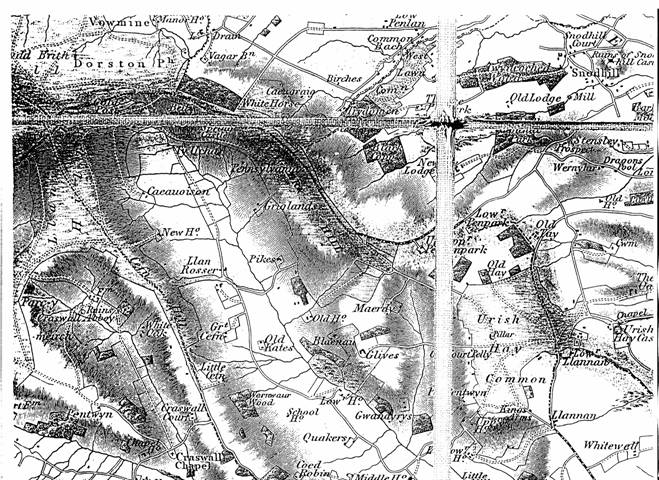
Title: | Map of Michaelchurch, Crasswall and Urishay area (part 1) |
Place name: | Ewyas Lacy |
Date: | c.1835 |
Description:
Bryant’s Map shows the principal dwellings and place names in the Escley and Monnow valley area in the early 19th century.
Observations:
| Places shown: | Beils | Birches | Black Coppice | Blaenau | Cae ugraig | Caeuoison | Cefn Hill |
| Chapel House | Coed Robin | Cold Post | Common Bach | Court Pelly | Crasswall Abbey | Crasswall Chapel | Crasswall Court |
| Cwm | Dragons Pool | Glives | Great Cefn | Great Cefn | Griglands | Gwandyrys | Kings Arms |
| Little Cefn | Llan Rosser | Llannan | Lower Penlan | Lower House | Lower Llannan | Lower Penpark | Maerdy |
| Middle House | New House | New lodge | Old Hay | Old House | Old Kates | Old Lodge Mill | Old Tay |
| Parc y meirch | Pennsylvania | Pentwyn | Pentwyn | Pikes | Quakers | School House | Snodhill Castle |
| Snodhill Court | Spring Castle | Stensley Prospect | Trydoinen | Twyncoched Wood | Ty Ucha | Upper House | Upper Penpark |
| Urish Hay Castle | Vagar Barn | Vagar hill | Vowmine | Wernwaur Wood | Wernyhir | West Lawn Common | White Horse |
| White Oak | Whitewell |
Ref: rs_ewy_0018