
Title: | The Periglacial Formation of the Black Daren in the Black Mountains |
Date: | Post Glacial Period, 11-12,000 years ago |
Ewyas Lacy is located on the eastern foot hills of the Black Mountains. The east facing escarpment of the mountains forms the dramatic western horizon from all viewpoints within the Hundred. When looking towards the mountains the most prominent features of the escarpment are the two exposed rock faces known as the Darens, the Red Daren at (SO292303) and the Black Daren (SO291298).
The sedimentary rocks of the Darens and the whole of the Black Mountains were laid down over 300 million years ago when in the Devonian period the land we now stand upon was located somewhere south of the equator. The area was one of shallow seas off the coast of a large continent. We know the continent was large since it held massive rivers which brought down large quantities of finely abraded sand which settled in the immediate seas to form great depths of material later transformed into our local sandstone which here has a thickness of over 2000 feet. The sea bed at that time was slowly sinking under the weight of the superimposed deposits. About 50 million years later the sea bed rose and in its shallows formed the area of the tropics which held the plants that became the coal deposits of the Carboniferous period. Another 50 million years or so passed before the collision of tectonic plates in the Hercynian epoch thrust up what is now most of Wales including our own Black Mountains.
Both Darens in geological terms are very young features having been formed at the end of the last Ice Age about eleven to twelve thousand years ago. They have been described as ‘armchair’ Corries which have a different mechanism of formation from the true Corries to be found in the mountains of North Wales and Scotland. The name ‘armchair’ comes from their resemblance to ginormous armchairs perched on the hill side, the back of the armchair being the exposed rock face and the seat of the chair being the terrace of earth and rock fragments which has resulted from the debris stripped from the rock face. The present road and car parking area at map ref. SO298299 are located on this ‘seat’. The Darens were formed from the very particular circumstances of their location and events which occurred in the last ice age and the conditions which existed at the end of that ice age.
|
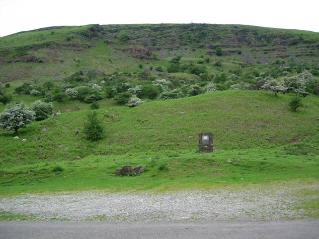
The Black Daren from the public road and car parking area at SO298299 |
Key to the formation of the Black Daren is the size, shape and orientation of the hill on which it is formed. The hill is part of the long ridge which separates Ewyas Lacy and Herefordshire from the valley of the Honddu in neighbouring Powys. This ridge is some 10 miles long and runs from the peak called Lord Herefords Knob in the north to Trywyn on the Hatterrall Hill at the southern end, it runs in general terms from NW to SE. Its height varies between 2300 ft and 1500 feet. The top of the ridge is flat or gently rounded with a width in the region of the Black Daren of 400 to 500 yards This width is critical, had it been wider or narrower the Daren would not have been formed.
In the last Ice Age ice caps were formed over most of the Welsh mountains. These arose when the climate was such that the snow falls in the winter season were not completely melted in the following summer season. In subsequent years snow falling onto the previous year’s fall built up the thickness of snow whose weight then compressed the snow into ice, forming the ice caps. However these ice caps were not of a uniform thickness. In the hill top area immediately above what is now the Daren the hill top was wide enough to attract a significant fall of snow but narrow enough and exposed enough for the snow to be swept off by the wind. The prevailing wind then, as now, was from the SW. This resulted in extra snow being deposited on the lee side of the hill, that is towards the NE. The extra snow was sufficient to build up locally a great ramp of ice on the hillside where the Daren was to be formed. This condition persisted for about 13,000 years that is from 25,000 years ago to 12,000 years ago.
|
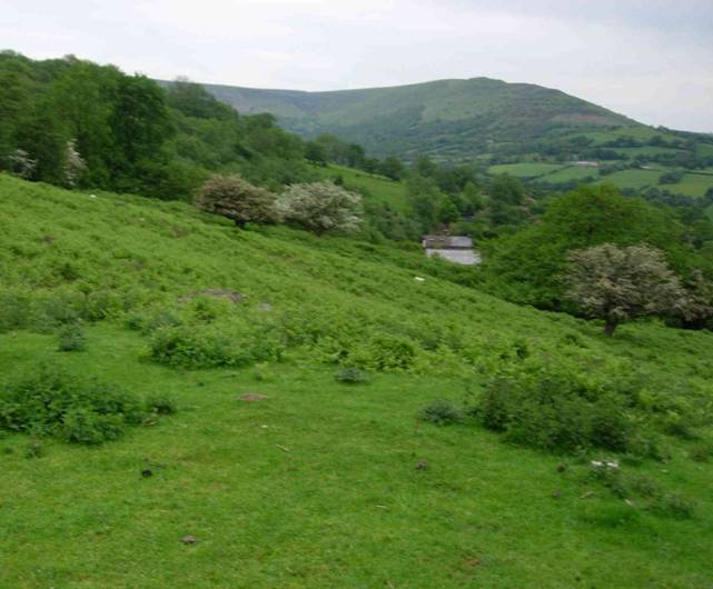
View looking north from the car park area at SO298299. |
At the end of the Ice age, about 12,000 years ago, there was a climate change. Things gradually got warmer and the ice deposits started to melt and disappear. However this did not occur overnight, nor in a single decade; the melting phase lasted for several centuries. Where the ice was thinnest it was quickest to go. So a situation developed where the top of the hill was clear of ice but the great ramp of ice on its lee side still existed. Water running off the hill top would melt a crevice between the hill and the top of the ice ramp. Water in this crevice would be subject to repetitive freezing and thawing many times each winter. On each freezing cycle the frozen water would expand and actively pluck earth and rock from the hillside These materials would be deposited onto the top of the ice ramp and gradually slide down to form a ‘tumble’ of material at its foot. As the ice ramp progressively melted and got smaller in size the deposited material would be left nearer and nearer to the foot of what is now the Daren. The end result of this process is what we see today.
|
High on the left hand side of the Black Daren Showing local washout channels, looking south |
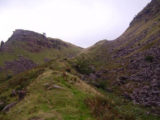
At the top of the Black Daren, on the left as one faces it, are some minor features of interest, called by some landslips. These are most likely channels caused subsequent to the main formation by washout water. Being high on the Daren they are on that part which was first stripped of its cover, that is present at an early stage in the formation. At that time there would have been lots of melt water in evidence and water flows very vigorous. These channels are visible from a viewpoint near Clodock Church as a notch on the hillside skyline just below the top of the crest.
For further details of the local conditions at the time of end of the last of the ice ages click here
The explanations offered here are original and come from the research and observations of the author.
George Charnock, March 2010
Ref: gc_ewy_3063