
Title: | A Study of Properties in the Upper Escley Valley |
Date: | c.1566 - 1844 |
Editorial Note:
This paper is the product of years of detailed research which Tony Gray was sadly unable to complete because of illness. It is clear from his working notes that there are many facets of the history of the area and its properties he had intended to expand upon, and a number of aspects of the work that he felt still required further investigation and elaboration. Nevertheless this is a unique and important study that deserves publication as it stands; with the kind permission of his widow we have simply ‘tidied up’ his draft in places for presentational and continuity purposes.
Ewyas Lacy Study Group
The Upper Escley Valley ,
Michaelchurch Escley, Herefordshire
A study of the northern part of the parish
with details of all properties prior to the Tithe Map of 1844
Tony Gray
2012
Contents
Introduction
Background
The Manor
Tithe Map
Areas
The Upper Valley
Location
Buildings
Construction
Properties and People
Appendices
Appendix 1: Summary of Manor holdings of main farms and land as at 1700
Appendix 2: Summary of the Royal Commission on Historical Monuments Report
Appendix 3: Listed properties in Upper Valley area
Appendix 4: Summary of Farmhouse dates
Appendix 5: Summary of Owners and Occupiers by Date
Appendix 6: List of Upper Valley Properties by Acreage
Appendix 7: Wills and Probate Documents
References
--------------------------------------------------------------
Introduction
The aim of this study is to discover and document the history of the land, buildings and people in the upper part of the Escley valley from early times up to the date of the Tithe Map published in 1844. At that date the area comprised some 40% of the parish of Michaelchurch Escley.
The study area is shown on Map 1 below, being broadly the part of the Escley Valley north of the red line that marks the 280 metre level in the valley floor.
Map 1: The Upper Escley Valley [click map for higher resolution image]
Background
The majority of land and property in the study area fell within the Manor of Ewyas Lacy and old Manorial surveys have supplied much of the data used. Transcripts of such surveys particularly by Nina Wedell and Dewi Bowen Williams BA, have been enormously helpful. However such surveys cannot paint a complete picture. Additional information has arisen in particular from the work of the Ewyas Lacy Study Group [1] and from the loan of documents in private ownership. Data from the Royal Commission survey of 1931 [2] as well as listed property data has also been included.
The Manor
The history of the development of Manor of Ewyas Lacy from ancient times is well recorded on the Ewyas Lacy Study Group web site [3] , as is the descent of the Lordship of the Manor from Norman times to the present day [4] .
Briefly, in 1241 the Manor was divided into two parts held by the grand-daughters of the Norman Marcher Lord Walter de Lacy, Maud and Margaret. Margaret’s part soon found its way into the Earl of Abergavenny’s family and remained there until final disposal in 1920. Maud’s part passed through varying hands including the reigning monarchs. It was given to Dudley Earl of Leicester by Queen Elizabeth 1 and from then it was owned for the longest periods by the Hopton and then the Jeffries families.
For the purposes of this work, the two holdings are referred to as Abergavenny and Hopton.
The earliest Abergavenny survey was conducted in 1624 [5] and again in 1701 [6] with numerous other terriers and lists thereafter. The earliest Hopton survey on which this work is based, is that carried out on behalf of Dudley in 1566 [7] . A survey of properties was produced on sequestration of the Hopton Manor in 1653 [8] and another major survey was carried out in 1705 [9] for Jeffries.
The two parts of the Manor demised property as freehold, copyhold and leasehold [the expression hallmote used in the Dudley survey having been dropped]. Freeholds were the main form of demise, generally at a rent of 1d per Welsh acre. Surveys usually provide only the name of the freeholder and rent payable with no description of the land area. Many of the freeholds would be very ancient, arising out of the form of mediaeval service provided to the Manor.
Copyholds were effectively perpetually renewable leaseholds with a fixed rent usually at 3d or 4d per Welsh acre. They were granted for lives, usually three, but such lives were replaceable with another life as necessary subject to payment of a ‘fine’ to the Lord of the Manor, as adjudicated by the Manorial Courts. Copyhold surveys are the most useful for property information usually providing tenant name, rent, field names and areas and, most usefully, the names of adjoining land holders. Again, the form of tenure arose out of the nature of mediaeval service provided to the Lord.
From evidence in this area, leaseholds tended to be long, usually 80 or 99 years. Hopton granted several but no examples of long leases from Abergavenny have been found. There are no shorter leaseholds from Hopton in the area but Abergavenny did grant some in the later years. Leasehold terriers also often produce useful additional information.
There is evidence of Hopton holding freeholds from Abergavenny. These would most probably have arisen by purchase by Hopton or his predecessors, rather than any demise by Abergavenny.
The evidence available from the various surveys and terriers tends to reflect the superior legal interest below the Manor. It does not usually produce the names or tenure of the occupiers of the property who would have held on shorter leases. In this area it would seem that in the earlier period up to around 1700 many superior interest holders were actually in occupation but that as time progressed more of them became landlords and sublet to occupational tenants.
Old surveys generally stated area based on the Welsh acre. There is differing advice as to the relationship with the English or Statute acre, but that used in this study is 4 English = 1 Welsh as stated in the 1566 Dudley Survey. That survey also advises that
“The … tenants…are… the most part freeholders as they have long continued, but without any writing or charter which freeholders pay for every Welsh acre they hold which is in quantity 4 English acres, 1 d and no more, nor never paid more. Some copy holders there be, which pay for every Welsh acre 4 d , likewise there be an other tenure which is called hallmote for the which every tenant payeth for a Welsh acre 3 d …”
The freehold and copyhold interests of the primary farms [over 10 acres] held by the two parts of the Manor as at 1700 are shown at Appendix 1. Using a rent analysis of 1d per Welsh acre freehold, 3d copyhold and three/four English acres to one Welsh, the land area held freehold from Abergavenny is 436 acres and Hopton 520 with copyholds at 309 and 312 respectively, giving a total of 1577 acres. This is a little higher than the Tithe map area so the mathematical analysis does not give a perfect result.
The Tithe Map 1844
The schedule and map of land holdings produced for the commutation of tithes to rent charges [10] , is probably the most valuable document available when studying land holdings. It provides the names of landlords and occupiers and a full breakdown of fields giving use in many cases and areas. Work in this area has shown that in fact very little had changed over the previous three hundred years and the arrangement of fields and their boundaries has proved a primary tool in analysing previous land holdings.
By the time of the Tithe map, many of the properties held by the Hopton Manor had been sold. Further research is needed to identify precisely when remaining manorial interests terminated and in particular what happened to Abergavenny holdings between 1844 and their disposal in 1920.
In 1844 Michaelchurch Escley comprised some 3900 acres of land of which around 40% [1564 acres] fell within the Upper Valley area. The farms over 10 acres made up 1514 acres as shown at Appendix 6. These farms included three at or over 100 acres, another eleven over 50 acres and another twelve over 10 acres, 26 farms in total. In addition there were another 12 holdings comprising small farms or purely land.
Overall in the parish, arable made up 950 acres [24%], pasture and meadow 2250 acres [58%] and woodland 700 acres [18%]. Further research is required to analyse the equivalent breakdown for the Upper Valley .
The Tithe assessment gave names of landlords and occupiers, excluding the two Lords of the Manor. In the upper valley area, farms over 10 acres were generally not owner occupied. This would seem to suggest they were seen as a “good” investment. However, landlords were named individuals, so land was not held by estates, universities etc a reflection perhaps of its generally poor quality compared with say, the Golden Valley .
Despite the obviously very hard working conditions for farmers in this area – high elevation, weather exposure, poor soil quality, difficult terrain, very poor communications etc – during the study period, all farms appear to have been held by an investor or owner/occupier. Actual occupation cannot be truly measured due to limited data.
Areas
Michaelchurch Escley can loosely be divided into four areas:
- Upper Valley
- Exton family holdings
- Michaelchurch Court Estate
- Southern area
with in addition lands to the north and south of Urishay Common.
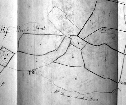
The Upper valley comprised a number of good sized farms and land holdings particularly Ty Ucha, Caieron [a Manor], New House, Griglands, Llanrosser, Pikes, Old House, Maerdy, Blainey, Glibes, Great & Little Cefn & Upper Lower House. They form a ring up and down each side of the valley with original access from Vagar Hill or Cefn Hill commons. Hopton Manor holdings and freeholds predominated.
The Exton holdings comprised a swathe across the valley including Quakers, School House, Wern Derrys and slightly further south, the Firs.
The Court Estate [part of the Hopton Manor] began to form around Michaelchurch Court in the central part of the valley, including Bank Farm and subsequently by acquisition, Firs, Cefn Keist, Grove and Wilderness Farms.
The southern area was a mixed bag of larger farms and small tenements with broken land holdings. Abergavenny tenancies predominated in this area.
Urishay Common and the lands between the upper part of Michaelchurch Escley and the Golden Valley were dominated by the Delahays from Urishay Castle, and Manor holdings were mixed including a Hopton sub manor at Clothiers.
The Upper Valley
Location
The upper valley area is broadly defined on the Ordnance Survey map as that part north of where the 280 metre contour crosses the valley floor [see Map 1]. In this area the land rises to 420 metres at its highest occupied farm and to 434 metres on the Vagar Hill and 480 metres on Cefn Hill. Orientation is NW/SE. The Escley brook runs through the valley with a number of feeder dingles. To the east are farms around the Urishay common, a flatter area with an easterly aspect.
The upper part of the parish was serviced from north/south routes on the higher ground and along the parish boundaries, which formed part of longer communication routes. On the east side, from the Kings Arms across Urishay Common and on to Vagar hill was part of a route from Ewyas Harold to Clifford. On the west, forming almost the entire parish boundary, was the Cefn Road , the main route from Abergavenny to Hay passing across the Cefn Hill. Both these routes kept to the high ground with access tracks dropping down the valley sides to the farms.
In the valley itself, evidence supports routes from the area of the church rising diagonally across the contours, past Coed Robin with a route across the valley to Old House and onwards. There were also cross valley routes at several places such as past the church, the mill, from lower Urishay common, and from Vagar to Cefn hills via Pikes pitch.
The current valley route is shown on the 1844 Tithe Map but peters out by Caeiron. Even at that time, the hill routes were still the main routes out of the valley to the north.
These hill routes passed over two extensive commons – Vagar Hill to the north [120 acres] and Cefn Hill to the northwest/west [190 acres in the parish]. Also Urishay common of some 195 acres lay to the east. These commons were very important to farmers, providing good summer grazing.
The Upper valley area contains three of the six standing stones of the county; flint workings have been found at the head of the valley and axe heads have been found – all providing good evidence of ancient occupation.
Buildings
This part of the parish is typified by old and rebuilt stone farm houses and barns with very limited new building. With the exception of Upper Lower House, all lie along the valley sides and reflect a very ancient pattern of farms with access from one of the two commons. Some, mostly smaller holdings, were created out of encroachments onto the commons
The local stone is Old Red Sandstone which, in this area, typically splits into fine layers. Current quarries still provide roof tiles, flagstone and building stone and no doubt in the past, such stone was readily available from local quarries.
Of the 26 farms at the time of the Tithe Map 1844, 12 are now Listed, all Grade 11 except the Glibes which is Grade 11*. The listing gives generalised construction periods of C17-C18th with few exceptions, with some adjoining barns slightly earlier.
The Royal Commission on Historic Monuments considered buildings of pre 1700 date. In its Herefordshire Volume published in 1931, it listed ten properties in this category in the study area [see Summary of Royal Commission entries in Part Two]. For reasons unknown, it omitted several farmhouses that met their criteria.
However, documentary research and recent dendrochronology analysis suggests that many of the farm houses and barns are older in part or whole than the Listing or Royal Commission reports. For example, dates for Tyn-y-gwynt were early and late C17th but dendro work suggests the first half of C16th. Pikes Farm is listed as being late C17-early C18th whereas dendro work suggests C13-14 th for some timber and C16th for the insertion of a chimney into an earlier hall house and an extension.
There are three barns in the area with cruck frames and a listing date of C16-17th, one of which at Upper Pen-y-park is referred to in documents dated 1546 as a Tithe barn for the parish
Two farms are dated - The Caeiron at 1681 and part of the barn at Great Cefn at 1677. Whilst these are undoubtedly correct, documentary evidence on both properties can be linked as far back as 1566. In can perhaps be fairly assumed that many “newer” [C17-18 th ] farms in the area have been repaired, extended or rebuilt on existing sites and available documentary evidence from the C16th and C17th does of course refer to a holding that was in existence at that time, whilst the original construction date of a building could be much earlier.
Construction
Although building, roofing and floor stone was readily available in the area, timber was probably widely used in the past. Richard Suggett suggests that originally timber framed hallhouses with thatched roofs were re-walled with stone and re-roofed with stone tiles, and this procedure must have happened in this area.
Evidence of old building methods is scarce but in 1577 a lease was granted on a two acre holding called Randiroth near Pen-y-Park with a proviso that “ The tenant to build a dwelling house of three rooms of sawn timber and to be responsible for repairs.” This is perhaps the first “solid” house on the land, to be of “sawn” timber, as opposed one might assume, to un-sawn or rough “poles” and mud which might have been the earlier construction method. Three rooms suggests either a two cell ground floor with a attic above or three ground floor rooms, possibly two for the occupier and one for animals. Although in this case the tenant was a tailor he probably still had his own animals. If the cottage was to have a sawn timber frame then the walls would have had a lath & plaster infill and the roof probably thatch.
Documentary evidence considered in this Study, can be used to further interpret the Royal Commission Report and current Listing. It suggests the majority of houses in the area were built in the C16th [14no] followed by the C17th [8no] with one in the C15th [see Summary of Farmhouse Dates].
Some houses would be on the site or land of earlier houses not recorded, some have since gone whilst others are considerably altered. The design forms of the 23 still existing in the Study area are summarized in Table 1. The most common design form was the two cell plan [9no]. Others had hall house origins now called longhouses [4no] whilst the rest were of mixed design form [10no].
|
| C17th | C16th | C15th |
| Two cell houses | Lower Llanrosser | Blainey Farm cottage |
|
|
| Great Cefn | Griglands |
|
|
| Upper Lower House | Old House |
|
|
|
| Glibes |
|
|
|
| New House |
|
|
|
| Old Kates & barn* |
|
|
|
|
|
|
| Hall house origins now longhouses |
| Pikes* | Old Hay* |
|
|
|
|
|
| Possible hall house origins now longhouses |
| Upper Pen y Park |
|
|
|
| Tyn y Gwynt* |
|
|
|
|
|
|
| Mixed design form | Caeiron | Upper Llanrosser [now gone] | Upper Pen y Park barn* |
|
| Little Cefn | Ty Uchaf [now gone] |
|
|
| Sunnybank | Blainey Farmhouse |
|
|
| Lower Pen y Park | Upper Lower House barn* |
|
|
| Pucca | Old Walls |
|
|
|
| Randiroth |
|
*cruck frame existing or now removed
Table 1: Building Design Forms
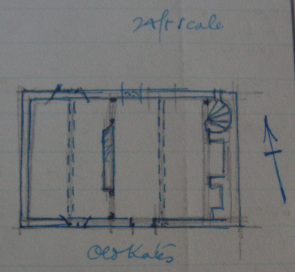
The two cell plan house is well illustrated by Old Kates. The main structure is a stone walled rectangle divided on the ground floor into two cells usually by oak paneling. One large fireplace lies to one end with a spiral stair in the chimney recess. The attic would comprise a divided area with low headroom.
The best example of a hall house converted to a longhouse when the chimney breast was added, is Old Hay.

Structurally, the hall house had five pairs of crucks creating four bays and supporting the roof timbers. The left end “inner” bay was divided by a timber partition into two service rooms often with a sleeping area above accessed by a ladder. The hall, originally with a fire on the floor, occupied the next bay and was open to the roof. Next was the cross-passage for human and animal access and finally was the byre or “outer” bay for animals. The chimney breast was added usually with a spiral stair in the corner [not built or later removed at Old Hay]. After the addition of the chimney, current parlance described the property as a longhouse.
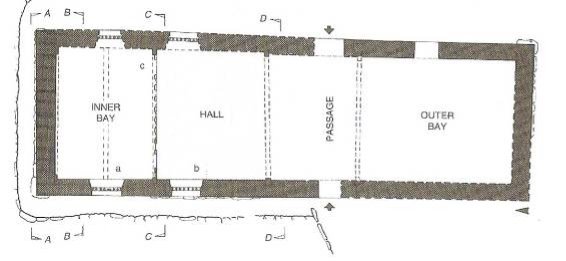
A typical floor plan of an original hall house from Suggett
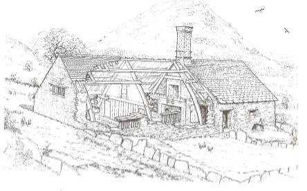
Cutaway drawing of a typical longhouse from Suggett
Properties and People
This section summarises documentary evidence relating to each property in the Upper Escley Valley and the occupiers and owners up to the Tithe Map of 1844 and is arranged by farm area at that time. Each property is described based on documentation extant, including the 1931 Royal Commission and 1971 Listing entries, Tithe Map extracts and schedules, and surviving Manorial and other documents. Alternative names for each property are given where relevant, and details of main occupiers with relevant dates are provided so far as they are known. Document references where given identify the archive where the document is held, followed by the reference number in the format used in that archive collection; the archives sources are HRO [Hereford Record Office, now Herefordshire Archive and Records Centre], GRO [Gwent Record Office, now Gwent Archives], NLW [National Library of Wales, Aberystwyth] and ELSG [Ewyas Lacy Study Group]. Most of the original source documents, surveys and reports can be viewed online on the Ewyas Lacy Study Group website. [11]
Part 1: Farms over 100 acres
The Maerdy
The property name has been spelt in numerous ways – Merdee, Mayrduy, Merday, Merdey, with Merdy and Maerdy in the Tithe Map.
Documentary records of the two Manors do not include any information regarding the building
Royal Commission 1931: not recorded
Listing 1971: not listed
Tithe Map 1844:
Thomas Delahay is given as the landowner in the Tithe Map with Thomas Jones as occupier. The area is 144a 1r 18p. The farm obviously expanded over the years by some 38 acres, perhaps with the inclusion of land adjoining the common.
| 286 | Cae Mawr | pasture | 20.2.27 |
| 287 | Cae Mawr | pasture | 16.0.35 |
| 288 | Long Mawr |
| 4.2.18 |
| 289 | Cae Mawr |
| 4.3.5 |
| 290 | Cae Mawr |
| 4.3.6 |
| 300 | New laid ground |
| 5.1.31 |
| 301 | Piece above house |
| 5.3.4 |
| 302 | Six acres | arable | 5.3.7 |
| 303 | Part of Cae Mawr | pasture | 0.0.21 |
| 346 | Big meadow |
| 10.1.38 |
| 347 | Road |
| 0.2.1 |
| 348 | Homestead |
| 0.2.27 |
| 349 | The Plock |
| 1.3.31 |
| 350 | Garden |
| 0.1.6 |
| 351 | Garden meadow |
| 1.3.32 |
| 356 | Rough in garden meadow | rough | 0.1.4 |
| 357 | Gate meadow |
| 2.3.16 |
| 358 | Long meadow |
| 2.1.13 |
| 359 | Long meadow |
| 3.0.26 |
| 366 | Broomy field | arable | 5.0.39 |
| 367 | Quarry field | arable | 7.1.2 |
| 368 | Lower wood | rough | 5.3.35 |
| 370 |
| arable | 7.1.37 |
| 371 | Three acres | arable | 3.0.15 |
| 372 | Upper wood | wood | 4.1.21 |
| 373 |
|
| 3.3.0 |
| 420 | The Boobies | rough pasture | 14.1.38 |
| Total |
|
| 144.1.18 |
Manor & Tenure: Held freehold from Abergavenny and sub let.
Documentary evidence:
The 1701 survey gives the Maerdy as demised freehold by Abergavenny to the Delahay family of the Urishay Estate and comprised a messuage and land at a rent of 3s 2d. At 1d per Welsh acre and 3 [4] English acres to one Welsh, this was equivalent to 114 [152] acres. Prior surveys do not identify the holding specifically but in 1624 there is reference to Delahay holding the land north of the Glibes, but how firm this is remains debatable.
The Land Tax records confirm the Delahays as landlords although George Reece Esq in shown in 1821 and 1826 perhaps as mortgagee. Occupiers included J Yeomans 1783, Timothy Howard 1789-1798, Robert Howard 1810-1826 then Thomas James in 1838. In 1832 Ann Williams aged 5 died at the property.
The 1841 Census gives the occupiers as Thomas Jones aged 60 farmer, Catherine 60, Thomas 30, George 25, Frances 20 and Amelia 20 plus William Evans 60 carpenter, William Waring 15 and Elizabeth Davis aged 6.
Caeiron
The Caeiron was one of two Manors granted out of the Hopton Manor. The other was the Clothiers adjoining Urishay common. As such it must have been a very early grant for services rendered to the then Lord but one might conclude that it was not a generous grant. The name,” windy fields”, rather gives it away and the land was fairly poor rough grazing.
The current farm house has a mason’s date of 1681. Clearly the holding was the site of a house well before this, dating back to at least 1566.
Royal Commission 1931: The property was included in the Royal Commission Report of 1931 – Appendix 2
Listing 1971: the farmhouse and barn are Listed Grade11.
Tithe Map 1844:
Mrs Maddy is given as landowner on the Tithe Map with William Prosser as occupier when the area is given as 115 acres.
| 56 | First way field | arable | 6.0.22 |
| 57 | Cae fach | arable | 5.3.26 |
| 58 | Field under garden | arable | 5.1.11 |
| 59 | Thistly field | arable | 3.3.29 |
| 60 |
|
| 5.0.3 |
| 61 |
|
| 4.3.39 |
| 76 | Cae Minnys |
| 5.0.36 |
| 77 | Rough in Cae Minnys | rough | 1.0.17 |
| 82 | Quarry meadow |
| 3.2.12 |
| 82a | Part of quarry meadow | rough | 0.3.1 |
| 83 | Little meadow |
| 1.2.32 |
| 84 | Big meadow |
| 5.1.12 |
| 85 | Sour meadow |
| 11.0.19 |
| 86 | Homestead |
| 0.1.29 |
| 87 | Field above house | arable | 4.3.11 |
| 88 | Cae Mawr | pasture | 34.1.35 |
| 89 | Cae Mawr | arable | 15.0.31 |
| Total |
|
| 115.0.7 |
The difference in land area from 78 acres in 1566 to 115 by 1844 may be due to encroachment onto the Cefn Hill with the fields called Cae Mawr.
Manor & Tenure: Held freehold from Hopton
Documentary evidence:
The 1566 survey shows a freehold from Hopton to Thomas Whitney at 2s 2d for 26 Welsh acres of land equivalent to 78 English acres. No house is mentioned. The rent suggests the entry does relate to the Caeiron.
Prior to 1627 the property was held by Walter Lloyde who sold to Lewis Powell for £15 who in his will of 1643 left it to his nephew Thomas Powell or in default of issue to James Penoyre the younger. Thomas Powell married Elizabeth Price in 1655 and left the property to his son John Powell. By 1665 it was held by Thomas Powell and then back to a John Powell by 1702.
The only known description as to the area of the Caeiron is in HRO G28/4 from 1656 where it is described as
“Messuage called Cayee Oyron in Michaelchurch Escley, shooting in length between the brook called Eskley on the one end and the common or mountain called Keven Bache or Munith Kevenbache on the other in breadth between the lands late of John Watkins gent on the one side and lands late of Ralph Hopton esq in the occupation of Thomas Powell Mady and the said common or mountain on the other”
The brook is to the east and the common to the west. Lands late of John Watkins is New House and Thomas Powell Mady held Ty Ucha.
The 1665 Survey states “Thomas Powell holdeth freely … one messuage or Manor with divers lands … .. called Cay yr Oyron by the yearly rent of 2s 2d.”
The 1702 Survey under Barons and Manors states the Manor of Caicoyron was held free by John Powell at 2s 2d plus every 7 th year, Horngeld at 2s 6d and Mises when it shall happen at 2s 6d. Under free tenants it describes the holding as one messuage or Baronny with several lands thereunto belonging called Caye oyron.
By 1783 through to 1798 the landlord/freeholder was a Mr Price with Samuel Maddy in occupation. In the 1802 Poll Book there is an entry of Wm Maddy of Cliro and S Maddy as occupier. By 1810 Mr Maddy is given as the landlord still with Samuel Maddy as occupier and in 1826 the landlord is William Maddy with Thomas Pugh as occupier. Mrs Maddy is the landlord by 1838.
At the 1841 Census the occupiers are Henry Prosser aged 25 farmer, William 20, Susan 3, William 1 and Elizabeth Greenway aged 25. In 1843 an Emma Greenway aged 6 weeks died at Cae Iron.
Upper Llanrosser
The word Llanrosser has no connection with a church [Welsh llan]. Previous spellings include Lloyne Rosser, Llwyn Rhoser and Llwynrosser meaning Roger’s clearing.
Royal Commission 1931: not recorded
Listing 1971: not listed
Tithe Map 1844:
At the time of the Tithe Map, Henry Allen is the landlord and Joseph Mainwaring the occupier with an area of 104a 3r 25p
At the Tithe map the landowner is given as Henry Allen and the occupier Joseph Mainwaring with an area of 164a 3r 25p.
| 162 | Cae Mawr | arable | 11.2.23 |
| 163 | Cae Mawr | pasture | 12.0.8 |
| 169 |
| arable | 4.3.4 |
| 115 | Lower cae pant | pasture | 2.1.14 |
| 116 | Middle cae pant | arable | 2.3.33 |
| 117 | Middle cae pant | pasture | 0.2.35 |
| 118 | Upper cae pant | arable | 6.1.2 |
| 119 | Upper ground |
| 11.0.36 |
| 120 | Upper ground |
| 5.3.4 |
| 121 | The wood | arable | 0.1.29 |
| 122 | The wood | arable | 3.0.34 |
| 123 | Back green | pasture | 3.1.14 |
| 124 | homestead |
| 0.1.27 |
| 125 | Little long meadow
| meadow | 1.2.17 |
| 126 | Cae Davies | pasture | 1.3.8 |
| 127 | Piece below road | arable | 3.0.2 |
| 128 | Lower cae pant | pasture | 2.1.19 |
| 161 |
|
| 9.1.32 |
| 162 | Barn meadow |
| 5.0.28 |
| 177 | Cefn field | arable | 2.3.27 |
| 178 | Cefn field | arable & pasture | 1.3.32 |
| 200 | Callen | pasture | 11.1.38 |
| Total |
|
| 104.3.25 |
Manor & Tenure: The property is one of three in the area which were held within the Abergavenny Manor but held freehold by Hopton, the holder of the other part of the Manor. He let Upper Llanrosser on two long leases.
Documentary evidence:
Prior to the mid C18th, the land was held via two leases – one included the house, the other was just land each with a moiety of the main fields. Both holdings had increased in area from the earliest records up to the Tithe Map. It is known that the Cae Pant fields were not originally part of Upper Llanrosser and the Cefn Field and Callen may not have been original either. Omitting these fields reduces the Tithe area to 75a
The data on Hopton’s freehold is confusing. The 1624 survey gives two rents for the same tenure, 2s 6d and 2s 1d. The latter equates to 75 acres. A further confusion arises in that later Abergavenny surveys, 1701 and 1711, show the freehold interest divided into two, held by the two parties who were actually the long leaseholders, and at total rents of 2s 7.5d and 2s 3d – close but not the same.
It is known that Hopton did in fact retain the freehold as his successors, Jeffries, commissioned a survey circa 1750 which included the property. How this anomaly occurred is therefore unclear. Around 1700 Hopton was disposing of his estate and this may have led to uncertainty by Abergavenny’s survey writer as to who actually held the freehold. One of the different statements as to rent, and hence area calculation, does support 75 acres however and this corresponds to the reduced Tithe area.
As to the moiety arrangements, there is alas, some ambiguity here too. The wording could suggest the land area to be 30 acres divided equally or that an equal division gives 30 acres each.
What is clear however is that, from the 1653 survey, the house and lands were let on an 80 yrs lease from 1610 to Simon Clarke, now or late in the occupation of Thomas Clarke at a rent of 12s 6d. The demise comprised the messuage called Llwyn Rhoser with garden, a meadow called Gworlod Carn y Defed 4 acres, another meadow called The Plock 1 acre and the moiety of one close of pasture called Cae Mawr and Cae Coed {Cood} 30 acres.
In 1670 a new 99 year lease was granted to William James at £3 10s on Lloyne Rosser then or lately in the tenure or occupation of John Booth gent; in the whole about 42 English acres. William James died around 1700 and appears to have left his estate to John Carpenter. However, by 1702 this lease was in the hands of Edward Perkins.
The circa 1750 survey gave James Parry as leaseholder still at £3 10s and in the 1789 Land Tax, James Parry is given as the landlord with John Winson as occupier. In his will dated 1790, James Parry left a property called Little Lloyn Bhossen [a transcript error for Rosser?] to his wife Mary and then his son John but by 1796, Upper Llwynrosser freehold was held by Henry Allen with James Jones as occupier. William Williams occupied the property by 1810 and Joseph Mainwaring by 1821. Also on this date, the Land Tax entry was changed to an amount that would suggest the house and land was merged with the land only holding and the other fields, Cae pants, Cefn Field and Callen were included. Joseph Mainwaring was aged 55 in the 1841 Census.
The other moiety comprising purely land, was let by Hopton in 1611 to Harry David now or late in the occupation of Katheren Powell and comprising parcels of meadow and pasture near Llwyn Rhoser, at a rent of 12s 6d, the same amount as the house and lands. In 1663 a new lease was granted to William James, [who also held the house and land from 1670], and that lease was replaced by another from 1701 to Thomas Delahay gent, still at £3 10s. John Delahay is referred to as leaseholder in the circa 1750 survey. Thereafter there is no further reference to the land which suggests it too was acquired by Henry Allen and merged with his interest in the house and land.
At the 1841 Census the occupier is given as Joseph Mainwaring aged 55 farmer, Thomas 25, Joseph 20, William 15, James 10, Sarah 15 and Ann aged 10. In 1828, Mary had died aged 9 and Elizabeth died in 1830. Jasmine Mainwaring died in 1836 aged 47.
Part 2: Farms over 50 acres
There were eleven farms over 50 acres at 1844, spread around the study area.
Ty Ucha
Royal Commission 1931: not recorded
Listing 1971: not listed
Tithe Map 1844:
The Tithe Map gives Thomas Phillips as owner/occupier of 96a 3r 22p. Thomas Phillips is also given as landlord of Byld Bryth/Spring Castle with William Phillips as occupier.
| 4 | encroachment |
| 2.0.36 |
| 5 | encroachment |
| 1.1.6 |
| 6 | encroachment |
| 0.3.27 |
| 7 | encroachment |
| 1.1.11 |
| 19 | Tumpy Field | arable | 3.1.10 |
| 20 |
|
| 1.3.9 |
| 21 | Cae rettin | arable | 4.1.3 |
| 22 | Cae rettin | rough pasture | 12.1.16 |
| 23 | encroachment |
| 2.3.3 |
| 25 | Plantation | plantation | 0.1.37 |
| 26 | Plock | arable | 0.2.27 |
| 27 | Cae Coed | rough pasture | 4.3.0 |
| 28 | Upper Four Acres | arable | 3.1.9 |
| 29 | Nine Acres | arable | 4.3.39 |
| 30 | Long Field | arable | 3.0.20 |
| 31 | Lower Four Acres | arable | 2.0.32 |
| 32 | New Field | arable | 3.3.5 |
| 33 | Homestead |
| 0.1.17 |
| 34 | Lower Garden | arable | 0.3.8 |
| 35 | Tumpy Meadow |
| 8.0.20 |
| 52 | Pen y Coed |
| 4.0.27 |
| 53 | Middle Quarry Meadow |
| 6.2.22 |
| 54 | New Meadow |
| 5.1.18 |
| 55 | The Wood | rough pasture | 10.3.26 |
|
| Total |
| 96.3.22 |
The increase in areas between the surveys and the Tithe area is most likely due to commons enclosure. The most likely enclosures since 1750 are: 22 Cae Rettin 12,25 acres; 27 Cae Coed 4.75; 23 Encroachment 2.75; 4-7 Enclosures 5.5, totalling 25.25 acres. If deducted from the Tithe area, the reduced area is 71.5 acres, fitting well with 67-72 acre range given in the surveys.
Manor & Tenure: Ty Ucha [Upper House] was another property held freehold by Hopton from the Abergavenny Manor.
Documentary evidence:
There are two freeholds in the 1624 survey under which Hopton may have held Ty Ucha. Both give a rent of 1s 11d equivalent to 69 English acres. One relates to a messuage & land late Thomas William Powell & before his father Thomas James. The second relates to a messuage & 23.5 acres [70.5 Eng acres] late in occupation of Harry Thomas ap Richard.
As with Upper Llanrosser, two later Abergavenny surveys, 1701 and 1711, give the long leaseholder as the freeholder but this would appear to be in error [see Upper Llanrosser ].
Hopton let the property on a long lease in the same way as Upper Llanrosser . The first reference found to date is in the will of 1604 of Jenkin Madye of Pikes Farm, where he called the property Lloyne y waine. He held a lease of which there are no details except a chief rent of £6 and a further 40s to John Harrie Watkin and David William William Price. Jenkin Madye probably inherited the lease from his father William Madye. He left his interest to his wife & mother, both called Margaret & then his nephew Thomas Powell Maddy.
A 1656 document on Caeiron to the south, confirms that Thomas Powell Maddy held the property. By 1661, deeds relating to Ty Ycha give James Prosser jun in occupation and also mention a Ty Osha which James Probert sen occupied. The 1690/1700 sale for Sir John Williams shows William James paying £5 for Tyroclea.
Whilst the 1702 survey shows a Thomas Prosser west of Old Walls under the Philpotts lease, the main survey text shows a lease now held by John Carpenter, dated 1669 between Wyndham Esq & Wm James for a messuage called Teere Ycha wherein one Philip [?Steicus] did then inhabit and late in possession of said Wm James and at a rent of £5 pa. It related to an area of 67 acres and comprised a messuage & barn called Teere Ycha or Lloyne yr waine, meadow called Gwrlod y quarrel 8 days math [12 a], meadow Gwlod newith 3 days math [4.5a], close of rough & dry pasture in two parcells called Cae mawre 50 acres, all lying together, bounded on south by John Powell at Caye Oyron and Keven & Vagor on all other sides.John Carpenter was a relative of Wm James who inherited most/all his property.
The 1711 survey gives Thomas Probert as in occupation. By 1746, in his will, Timothy Price left property called Tyerucha/Tyetuha to his mother and then dau, both Margarets [check] whilst the circa 1750 survey has John Jones at Tyr ycha paying £5 pa on 72 acres.
Land Tax entries give William Parry as landlord in 1783 to 1798 which would suggest he had acquired the freehold from Hopton’s successors by then. Thomas Phillips is given as occupier in 1791 and 1798, the 1802 Poll Book gives a James Spencer as owner/occupier in the parish and by 1810, Mr Spencer of Hay is shown as landlord with Richard Jones as occupier. James Spencer remained as landlord but by 1843 Thomas Phillips is shown as landlord suggesting a purchase of the freehold from James Spencer.
Henry Phillips died in 1832 aged 2 and Mary Parry in 1835 aged 82.
The 1841 Census gives the occupiers as Thomas Phillips aged 50 farmer, Sarah 50, Sarah 45, Joseph 25, William 20, Hariett 7, Harry 10 plus Samuel Smith 50 publican and Jane Smith 60, Ann Jenkins 40 and William Davies aged 30 A Sarah Phillips died in 1844 aged 23
Blainey
The Farmhouse is probably C17th; T plan but possibly small cottage with an end stack and added cross wing. The two cell Cottage is probably C17th or early C18th, and the Barn is probably late C17th to mid C18th
Royal Commission 1931 : not recorded
Listing 1971 : the farmhouse and barn are Listed Grade11.
Tithe Map 1844 : By 1844, the Blainey was one holding. The Tithe Map gave 83.25 held by Thomas Harris as owner/occupier on 83a 1r 27p
| 273 | Quarry Field | 3.0.39 |
| 274 | Lower Ground | 9.1.21 |
| 275 | Cow pasture | 6.3.29 |
| 276 | Lower Cae Rhwyn | 5.1.37 |
| 277 | Pilldowns | 6.2.15 |
| 278 | Upper Cae Rhwyn | 5.1.21 |
| 295 | Cae Cocken | 2.3.0 |
| 296 | Cae Cocken | 3.3.19 |
| 297 | Pasture below Cae Cocken | 7.3.1 |
| 298 | Little Cae Cocken | 1.3.39 |
| 381 | Road | 0.0.16 |
| 382 | Adjoining Glebe homestead. | 2.2.12 |
| 383 |
| 0.1.5 |
| 384 |
| 2.2.9 |
| 385 | Homestead | 0.3.7 |
| 386 | Well meadow | 3.2.7 |
| 387 | Orchard | 1.0.12 |
| 388 | Orchard | 0.2.39 |
| 389 | Orchard | 1.1.36 |
| 390 | Lingetts | 5.3.38 |
| 391 | Cae Porkin | 3.2.38 |
| 392 | CaePorkin | 0.2.38 |
| 408 | Cae Llan | 6.2.26 |
|
| Given total | 83.1.27 |
Manor & Tenure : Originally the house and land were held freehold from the Hopton Manor and further land copyhold from Abergavenny; all later split between the Blainey and Old House
Documentary evidence :
House and Land
In 1665 John William Prichard held a messuage and land freehold from Hopton at 1s 2d, late William Prichard David and the 1663 Militia Assessment confirmed his name two years earlier. However, there is no relevant entry in 1566.
By 1705, the Blayney messuage and land was held by John Watkins at 1s 2d late the lands of William Richard Davies & formerly Walter Poskins.
The early Land Tax records seem to show the Blainey and Old House assessed as one with Mrs Green landlord/occupier in 1781 and James Jones in 1783.
However, by 1789, Thomas Harris was given as the landlord/occupier, appearing in the 1802 Poll Book and again in 1810, the 1818 Poll Book and 1844. Harriett Harris died in 1836 aged 20 and William Harris in 1839 aged 28
Land
In 1566, Henry Howell Gwillim Bean [ab Euan] held freehold land at 10d thought to be Old House. Old House held Tithe no 394 which could have linked with Tithe 391 etc via the Brook.
In the 1624 Abergavenny survey the entry identified as Glibes land, shows land to west and North west as being John Powell. The 1634 Visitation shows John Powell as alive then, son of James Harry Powell & grandson of Henry Howell Gwillim Euan.
1663 NLW BR/1663/149; a John Powell gent of ME died; Morgan Powell gent mentioned.
The1665 Trevor Williams survey gives a freehold of a certain parcel of land held by Sir Thomas Morgan lately purchased from Morgan Powell formerly in tenure of James Harry Powell [Morgan Powell’s grand father] at a rent of 6d.
In the 1702/5 survey, Sir Thomas Morgan Bart holds free a certain parcel of land lately purchased from Morgan Powell at 6d. This would equal 18ea and is possibly Tithe nos 408, & 390-392 of 16.5 each. They probably had road access by Upper Lower House as well as via Old House.
The 1807 Abergavenny HRO J91/1 gives Sir Charles Morgan now Thomas Harris adjoining the Glibes copyhold land. This would suggest the Blainey freehold land had merged with the house and land by this date.
The 1841 Census gives the occupiers as Thomas Harris aged 60 farmer, Elizabeth 55, Thomas 25, Elizabeth 20, Mary 15 and George Showet aged 15.
Tyre Cockham
For details of this Abergavenny copyhold, see Old House. The land was divided between Old House [30.5ea] and Blainey [22.5ea] apparently some time before the Tithe Map 1844.
Griglands
Royal Commission 1931: Not reported
Listing 1971: Not listed
Tithe Map 1844:
At the Tithe Map Griglands comprised a holding of 79a 3r 9p.
The 1844 Tithe Map gives three names as landowner – Thomas and George Attwood and Richard Spooner. The occupier is Thomas Price and the area 79a 3r 9p
| Field no |
|
| a.r.p |
| 129 | Middle Meadow |
| 3.3.3 |
| 130 |
|
| 0.2.21 |
| 131 | homestead |
| 0.1.8 |
| 132 | Saffron Meadow |
| 3.3.12 |
| 133 |
| arable | 2.0.35 |
| 134 |
|
| 3.1.6 |
| 135 |
|
| 2.1.18 |
| 136 |
| arable | 5.0.25 |
| 137 |
|
| 3.3.0 |
| 139 | Cae Gwynne | pasture | 24.1.36 |
| 140 |
|
| 3.2.31 |
| 141 | barn & foldyard |
| 0.1.15 |
| 142 |
|
| 3.1.19 |
| 143 |
| arable | 2.1.39 |
| 144 | Lower Meadow |
| 4.3.22 |
| 145 |
| arable | 4.0.1 |
| 146 |
|
| 1.1.36 |
| 147 |
|
| 4.3.38 |
| 151 |
| arable | 2.3.4 |
| 152 |
| arable | 2.0.0 |
| Total |
|
| 79.3.9 |
Manor & Tenure :
Griglands arose over time out of three tenures – Ievan Greges land a freehold from Abergavenny comprising two messuages and 18 acres; a freehold messuage and 25.5 acres nr Grigland from Hopton; Tire Griege 24 acres of freehold land from Abergavenny. In total 67.5 acres. The two messuages appear to be Upper and Lower Grigland but the other messuage is not located.
Documentary evidence:
Ievan Greges land
The 1573 will of Symond Aparrie of The Moore [now W hitehouse, Vowchurch] states “I doe give will devise and bequeath all that my tenement called Ievan Greges Lands ( Tir Ifan Gryg ) with all lands, meadows, leasows, pastures, woods, underwoods, unto the same belonging set lying and being in the said parish of Michaelchurch Escley unto the said John Parry and to the heirs of his body lawfully begotten. And for lack of such issue the remainder thereof unto the said William Vaughan and to his heirs for ever.”
The 1624 survey [p127] shows a freehold to Hopton for certain lands late Jevan David Grigg at 6d [equivalent to 6 Welsh acres and 18 English]. This would suggest that Hopton had let, perhaps on a long lease as elsewhere, to the Parrys and it was that lease that was referred to in the 1573 will. However the property does not appear in the 1653 sequestration survey as one might expect.
The 1655 [NA] will of Margery Parry spinster of Eastnor left to her brother, Valentine of Ewyas Harold gent, a messuage and lands called Grigsloyne where Thomas Quarrell dwelt which she had inherited from her mother Blanch Parry widow of Hereford.
In a 1656 [HRO K11/3727] letter Robb Higgins (son of Valentine Parry) wrote regarding his aunt Mrs Margery Parry deceased & father Mr Valentine Price [or Parry?] regarding land held by Wm Bridges. There was a Statement from Thomas Price relating to a house and land late Tho & Ja Garrells and Ja Quarrell was to hold the little house and garden adjoining paying 6s 2d to Mr Bridges. This would appear to be a reference to Upper Grigland
In 1657 HRO K11/3815 Grygloyn/Grigland was held by William Bri[y]dges of Tibberton who sub let to Richard Corbett for 21 years from 1657 at £5 10s. Now or late in tenure or occupation of Thomas Quarrell and then Thomas Price. A James Quarrell is given as to rent Little House [probably Upper Grigland ] for an extra 6s.
In 1665 it was held [?leasehold] by Parry family, demised to William Bridges and leased by him - two houses
The 1667 will of Valentine Parry of Ewyas Harold left To Eliz Wotton my d the house called Grigloyne in Michaelchurch remr to Valentine Trice my gr child.
There is a 1701 6d entry – Abergavenny freehold held by James Price son of John Price dec’d one messuage and land at 6d. James’ will dated 1697 left a property in ME to brother John. This follows through to 1711 when it is held by John Price of Walterstone for a messuage and land now in possession of James Phillip Smith, at 6d.
For these to be correct follow-ons, Hopton would have to have sold the freehold.
1776 Whitfield Estate papers HRO BB2/40 Grigland farm ME included within a list of others suggesting it was part of the Estate – this might be the Parry leasehold.
Messuage & divers lands Nr Grigland
In the 1566 Survey, William Cecil gent held 8.5 acres of free bond land at 2s 1.5d. This equates to 3d per Welsh acre would be 25.5 ea.
The 1665 survey shows Thomas Smyth holds freely one messuage and divers lands near the Grigland formerly the lands of William Prees William at 2s 1.5d
The 1702 survey shows Thomas Smyth gent. held as a free tenant one messuage and lands near Grigland late Wm Rees Gwylim Johns at 2s 1.5d. Elsewhere it mentions land adjoining Pikes Farm as formerly William Price and late Thomas Smith which suggests the land included Tithe no 144.
Tire Griege
This entry in the documents is only included based on its name. However, the previous two entries do not add to the Tithe Map area and hence the name may be a strong reason for including it here.
In the 1590 Abergavenny survey of Indenture copyholders, David Thomas holds 8 Welsh acres at 8d late Richard Howell ap Rees. This is equivalent to 24 English acres.
The 1624 survey p121 lists a freehold called Tire Griege held by Leison Thomas late his father [David] & before Richard Howell Rees comprising 8 acres at 8d.
The 1718 comment in the 1624 survey reads “above Michaelchurch in possession of H Thomas Esq or William Watkins towards Blackhill”.
The land does not appear again in documentation and it may be that it was absorbed into the references to the large holdings of the Thomas family.
By the time of the Land Tax and Earl of Oxford Tithes there are two entries for Griglands [except in one year -1821]. Where a name is given, one is called Grigland and Gidlon whilst the other is both Upper Grigland and Lower Grigland and a tenement. By 1838 and probably 1828, both were in the same ownership and occupation
|
|
|
|
|
|
| LT | 1776-83 | Bridgwater | Nicholas Taylor | 15s 8d |
| LT | 1789-90 | Lewis | Taylor | 15s 8d
|
| Tithes | 1796 | Grigland: John Lewis | Joshua Maddy |
|
| LT | 1798 | Mr Lewis | Samuel Jones | 15s 8d |
| election | 1802 | Lytham Lewis | Samuel Jones |
|
| LT | 1810 | Mr Lewis | Mr William Jones | 13s 8d |
| LT | 1821 | Rev Sandiland | Thomas Price | 13s 8d |
| LT | 1826 | Richard Sandilands | Thomas Price | 13s 8d |
| LT | 1828 | Richard Sandiland | Thomas Price | 13s 8d
|
| LT | 1838 | Gidlon: Richard Sanderland | Thomas Price | 13s 8d |
|
|
|
|
|
|
| LT | 1776-83 | Mr Gloons [?Green] | James Parry | 19s 4d |
| LT | 1789-90 | Green | William Davis | 19s 4d
|
| Tithes | 1796 | Upper Grigland : John Green Esq | William Davis |
|
| LT | 1798 | Mr Green | William Davis | 19s 4d |
| LT | 1810 | JM Green Esq | Thomas Seaborn | 19s 4d |
| LT | 1826 | Tenement late Green | Thomas Price | 19s 4d |
| LT | 1828 | Tenement late Green | Thomas Price | 19s 4d
|
| LT | 1838 | Lower Gidlon : R Sanderland | not given | 19s 4d |
In 1828 a George Price died aged 3 and Elizabeth Price died in 1835 aged 37.
The 1841 Census confirms only one occupier – Thomas Price aged 40 farmer with Thomas 11, John 8 and Sarah Watkins aged 50.
A possible division of the holding based on the documentary evidence could be:
Ievan Greges land in red 17.2.33 cf documents 18 acres
Thomas Smyth near Grigland in blue 25.0 37 cf documents 25.5 acres
Tire Grege in black, is 24.0.0 in the documents but 36.3.0 remains. If Cae Gwynne had doubled in size over the years by encroaching on to the common, this would equate to the missing 12 acres.
Old Hay
Old Hay is one of the oldest standing properties in the study area. The cruck frame timbers could not unfortunately be dated but the house goes back well into the C16th and probably much earlier. The cruck framed Farmhouse, barn and buildings are perhaps C15th-early C16th; other buildings are probably C18th
Royal Commission 1931 : The property was included in the Royal Commission Report of 1931 – Appendix 2, including notes, sketches
Listing 1971 : the farmhouse and barn are Listed Grade11.
Tithe Map 1844:
By 1844 Old Hay comprised three elements although shown as one on the Tithe Map. It comprised 78 acres, part held leasehold [Pucca land], part copyhold [Kitchen land] and part freehold [house and land]. The landowner was Thomas Delahay and the occupier William Howell.
The Tithe field numbers/areas can be divided as follows to reflect the three tenures:
| Pucca land |
| Kitchen land |
| Old Hay house & land |
|
| 326 | 6.2.11 | 333 | 4.2.0 | 331 | 0.2.15 |
| 327 | 4.2.37 | 332 | 2.2.35 | 334 | 10.2.4 |
| 318 | 1.1.32 | 330 | 5.1.35 | 335 | 1.3.5 |
| 325 | 3.3.37 | 328 | 2.0.38 | 336 | 1.1.7 |
| Pt 324 |
| 320 | 4.3.20 | 339 | 4.1.36 |
| Pt 319 |
| Pt 324 |
|
|
|
| Pt 323 | 3.3.6 | Pt 319 |
|
|
|
| 322 | 3.0.1 | Pt 323 | 3.3.6 |
|
|
| 338 | 2.1.33 | 337 | 3.1.25 |
|
|
| 340 | 4.1.15 |
|
|
|
|
| 341 | 2.0.20 |
|
|
|
|
| Total | 32.1.32 |
| 27.0.0 |
| 18.2.27 |
| Overall/Tithe total |
|
|
|
| 78.0.18 |
Manor & Tenure:
The house and some 18 acres was held freehold from Hopton. 28 acres mainly immediately north of the house and sometime called Kitchen lands was copyhold from Abergavenny. The third area was a part of the Pucca copyhold lying to the east of the road
Documentary evidence:
House and land
The 1566 survey shows a Roger Vaughan, Knight holding freehold a messuage and 6 Welsh acres at 6d. This would be equivalent to 18 English acres. In the 1624 survey Richard Thomas Powell is shown as at Old Hay. In the 1663 Militia Assessment a Thomas Powell is listed and by the 1665 survey, Ann Church widow holds free one messuage and certain lands formerly lands of Thomas Powell. Her rent is given as 6.5d
The 1702 survey gives Thomas Church holding free a messuage & lands late Thomas Powell at 6d.
There is no further survey data for Hopton freeholds. However, by 1740 Thomas Smith is shown at Old Hay and he remains as landlord in the Poll Book of 1802 and in the Land Tax assessments up to 1810. Occupiers included Thomas Davies 1776, Thomas Smith himself, Samuel Lewis 1795 to 1810.
During from 1795 two identical entries appear in the Land Tax. They related to the house and the Kitchen land which were now in similar ownership and occupancy.
From 1816 to 1826, John Jones was landlord with John Roberts and then Robert Howard as occupiers. In 1830 Richard Hampton was landlord and by 1838 and at the Tithe Map of 1844, Thomas Delahay was the landowner with William Howells in occupation. Matthew Howells died in 1837 aged 2.
Kitchen Lands
This area was copyhold from Abergavenny. In the 1624 survey it comprised 27a 3r 37p held by Thomas William Prise at a rent of 3s. The land consisted of a large field immediately north of the house, a narrow dry pasture and two meadows. [Map 2 below]
The 1687 survey suggests John Price had held the copyhold but now Thomas Smith [also Smyth] at 3s for about 32 acres. It was bounded on the north by the Lords land in the tenure of Rice Price and east, south by south and west by Thomas Church – who held the house and also Upper Pen y Park
The survey provides some field names
A bakehouse in a meadow about 6 acres; A woody patch by it 1 acre; Erro Barre pasture 3; Another meadow 8; Kae Wintle oates 6; Kae Pont corn 5; Pasture between Wintle & Pont 1.5; A course meadow 0.5
This is the first reference to a meadow called “bakehouse” later to be “Kitchen meadow”. There must be a possibility that with such an old property, this was a reference to a separate kitchen in the field behind the house – so located to reduce fire risk. However, it could also be a reference to a more public bakehouse where parishioners could bring ground flour for baking. The location was adjoining part of the north/south route from Ewyas Harold to Clifford and a recognised trackway.
Thomas Smiths tenure is confirmed in 1711 but is given as “ in right of his wife” and holding by copy dated 14 th April 1692 comprising One bakehouse 12 acres customary land welsh measure now in his possession at a rent of 3s.
In 1720 Thomas Smyth the younger took a new copyhold on the kitchen land and 12 Welsh acres, assigning it to Daniel Smyth in 1744. In 1749 a new copyhold was granted to Henry Lanwarn [possibly as mortgagee] of Peterchurch on the kitchen land and 12 Welsh acres still at 3s rent and Mr or Mrs Lanwarn/Lanworne/Lanwain/Lanworn or Lanwarne appear as landlord until 1791. Occupiers in that period included David Jenkins 1776, Elizabeth Jenkins 1783, John Williams 1789 and William Williams 1791.
In 1792 a new copyhold was granted on Kitchen Meadow & named fields of 21 Statute acres at 3s, to Thomas Smith of ME yeoman. Field names were given as Kitchen Meadow 3 Sa, Errow Barr 3 Sa, John Preece Harry meadow 5 Sa and Cae Pant & Cae Winter 10 Sa; JPH meadow was bounded by Philip Davies [ LPP], Walter Harris [Pucka] & Th Smith [Old Hay]; separated from rest by Walter Harris land; rest bounded by Walter Haris & Th Smith
In 1793 Thomas Smith assigned the 1792 copyhold to John Jones. However, the early 1800s survey gives Thomas Smith holding 28a 1r 0p.
| 20 | Pasture next to house | Pasture | 8.0.18 | Pts 323 & 324, 337 |
| 21 |
| Meadow | 5.0.20 | 320 |
| 22 | Cae Colly | Rough & pasture | 15.0.2 | 328, 330, 332, 333 |
| Total |
|
| 28.1.0 |
|
Map 2: Old Hay ‘Kitchen Lands’
From 1795 on wards, the Kitchen meadow and Old Hay house were owned and occupied as one. However, the copyhold interest survived up to the 1920 sale when John Price the then copyholder, acquired the freehold.
Part of Pucca Land
The third part of the Old Hay land comprised a part of land held copyhold and then leasehold from Abergavenny. See Pucca for details. The leasehold interest was as held by John Price at the 1920 sale and merged when John Price acquire the freehold.
The 1841 Census gives the occupiers as William Howells aged 45 farmer, Mary 41, John 15, Elisa 17, William 15, Charles 10, Martha 8, Mary 3, Joseph 1 and Hariett aged 3 weeks.
Note that no account has been taken of papers relating to the Delahay family’s Urishay Estate and other holdings, which may contain further information.
Old House
Old House was previously called Cayer Brynn and Terre y Brynne.
Royal Commission 1931: The property was included in the Royal Commission Report of 1931 – Appendix 2 including notes and sketches
Listing 1971: Farmhouse Grade 11; probably late C16th – late C17th; 2 cell plan; Buildings Grade 11; probably late C17th to late C18th
Tithe Map 1844:
The Tithe Map for Old House shows the landowner as Representatives of the late Thomas Lanwaine with Howard Howard as occupier The land area was given at 77a 0r 37p. However, the added area is 73a 0r 38p which may be divided into the above three holdings as follows:
| 1843 Tithe Map |
|
|
| |
|
|
|
|
|
|
| 217 |
|
| 9.3.32 |
|
| 219 | Homestead |
| 1.1.18 |
|
| 220 |
|
| 2.3.36 |
|
| 223 | Cae Bont | arable | 3.2.3 |
|
| 270 | Gwilly Meadow |
| 11.1.8 |
|
| 271 | Bank |
| 0.3.0 |
|
| 272 | Bank |
| 1.3.38 |
|
|
| House & land |
|
| 31.3.15 |
| 394 | Copyhold : Gwilly Pasture | pasture |
| 10.2.12 |
| 221 |
| arable | 5.2.25 |
|
| 222 | Cae Cowney |
| 5.1.10 |
|
| 279 |
| arable | 4.3.37 |
|
| 280 |
| arable | 5.1.36 |
|
| 294 |
| arable | 4.1.31 |
|
| 299 | Upper Gorst |
| 6.3.32 |
|
|
| Part of Tyre Cockham |
|
| 32.3.11 |
|
|
|
|
|
|
|
| Total |
|
| 73.0.38 |
|
| Given Tithe Total |
| 77.0.37 |
|
|
|
|
|
|
|
Manor & Tenure :
The Tithe map holding was made up of a Hopton freehold which included the house and land spanning the river by Cae Bont [bridge field], an Abergavenny copyhold plus part of a further Abergavenny copyhold
Documentary evidence:
The house and land was first recorded in the 1566 survey when Henry Howell Gwillim Bean [ab Euan] held a freehold at 10d. He also held 33 acres of Hallmote land from Hopton. The 1665 survey gave Cayer Brynn as being held freehold by Morgan Powell [son of John] comprising 10 acres at 10d and by the 1702/5 survey Sir Thomas Morgan is shown as a free tenant of land previously held by Morgan Powell comprising 10 acres known as Terre y Brynne alias Old House. The rent was 10d.
In her will of1680 Lady Thomas Morgan; makes reference to property in Michaelchurch Escley bought by her husband from Morgan Powell.
The rent of 10d suggests a land area of 10 Welsh acres or 30 English acres.
The early Land Tax records appear to assess Old House and the Blainey together with a Mrs Green as landlord/occupier in 1781 and James Jones by 1783. From 1789 to 1798 the landlord of Old House is given as Mr James Jones and the occupier Samuel Jones. The 1802 Poll Book gives Thomas Llanwarn as freeholder and Timothy Howard as occupier. By 1810, Thomas Lanwarn [also Thomas Llanwarne] is still given as landlord and Tymothy Howard [also Timothy Howard] occupier and this position continued through 1826 [Auld House] and 1838 [Old House].
The 1841 Census confirms the occupiers as Timothy Howard aged 70 farmer, Hannah Lewis 15 and William Hughes 15. Timothy Howard died in1844 aged 73.
Copyhold land
The 1702/5 Survey gives Sir Thomas Morgan Bart with a copyhold by Court Roll dated 24th Oct 1698 at a rent of 11d pa. At 3d per Welsh acre, this equates to 3.6 Welsh acres and 11 English acres. One part of the copyhold is bounded by the river, lands of James Probert, lands late of Morgan Powell & now Sir Thomas Morgan and the Michaelchurch Escley-Lloyn Rosser road. This is Gwilly Pasture Tithe Map no 394 of 10.5 acres. James Probert was at Upper Lower House and the Morgans had Gwilly Meadow no 270.
[There is a second area of land which must be 0.5 ea and sounds to be up by the common adjoining Gr Cefn and Lower Llanrosser .]
Tyre Cockham
Lying between Old House and the Blainey was an area of Abergavenny copyhold land which was eventually to be divided between the two farms but meanwhile was held by the Morgans.
The1624 survey gives John Powell as holding two copyholds - one called Tyre Cockham at 7.5d for 2.5 Welsh acres; second 7 Welsh acres in tenure of John Harry Powell gent [father] at 1s 9d. The land lies together bounded on the west upon a lane to the common, north-west by a ditch bounding lands of David Howell Probert and on all other sides the free land of the said John Powell It contained in the whole, 26ea with a total rent of 2s 4.5d.
David Howell Probert was at Tyn y Gwynt. The lane was possibly on the east not west and servicing the Blainey. John Powell held Old House which was to the south west and south but Blainey was to the south east and held by Pritchard or Pritchard David. The exact boundaries are not entirely clear but the location is not in doubt.
1687 gives Sir John Morgan Barr [now Thomas Morgan] as holding a parcel of furry ground called Kae Cokane formerly in 2 parts both containing about 21 acres bounded on the west by lands of Mary Robert [Mary Probert at Tyn-y-Gwynt] widow and on all other parts the lands of Sir John [Old House]. The survey records some confusion about the rent and area. The bailiff advises that the rent was 4s 7d and the surveyor calculates this as representing 57.5 statutory acres. It would seem that this was a new copyhold, granted in 1687, which included more land and a higher rent
The 1711 survey gives Sir Thomas Morgan deceased now his grandson Thomas, holding the copyhold dated 1687 on 9.5wa called Tyre Cock[ham] now in the possession of Richard Shaw. Rent given as 4s 7d.
By 1718 the copyhold was held by Sir Thomas Morgan an infant son of Thomas but subsequently it was held by Thomas Harris [of the Blainey?]. Although this applied in 1858 according to an Abergavenny agent’s book, the Tyre Cockham land appears to have been divided between Old House, approx 33 acres, and the Blainey, approx 22 acres, by the time of the Tithe Map.
The documents show the following areas
House and land 30 acres
Copyhold land 11 acres
Tyre Cockham part 32.75 acres
Total 73.75 acres
Glibes
The farmhouse is a two cell house with attached two cell service area.
Royal Commission 1931: The property was included in the Royal Commission Report of 1931 – Appendix 2, including notes, sketches
Listing 1971: Farmhouse Grade 11*; probably C17th; Barn Grade 11*; probably C18th
Tithe Map 1844:
The 1844 Tithe Map shows Glibes with 69.5 acres with Stephen Heywood as the owner and Thomas Harris jun'r as occupier. The land includes both the freehold and copyhold lands.
There is discrepancy in the documents as to the area of the copyhold land. Although the rent stayed the same, the area given varied from 62ea, 82 ea, 82 covers, 30 acres to 22 acres. However, the earliest known demise of 15wa equal to 45ea, when added to the freehold of 7wa or 21 ea, adds to 66ea, very close to the Tithe Map area of 69 acres. It seems it was the division of the total area that was at issue.
The Tithe areas could be divided as follows to comply with this division:
| Possible freehold |
|
|
| 369 | 3.3.2 |
|
| 374 | 1.3.33 |
|
| 375 | 4.3.3 |
|
| 376 | 2.3.36 |
|
| Part 377 | 3.1.0 |
|
| 378 | 0.0.26 |
|
| 379 | 0.2.28 |
|
| 380 | 1.2.25 |
|
| 419 | 1.3.33 | 21.0.26 |
|
|
|
|
| Possible copyhold |
|
|
| Rest of 377 | 8.1.38 |
|
| 409 | 3.2.1 |
|
| 410 | 3.3.1 |
|
| 411 | 5.1.25 |
|
| 412 | 12.3.3 |
|
| 413 | 10.2.8 |
|
| 443 | 3.3.13 | 48.1.9 |
|
|
| 69.1.35 |
Manor & Tenure:
Glibes farm with some land was held freehold from Hopton, but the farm at the time of the Tithe map, also included some copyhold land. Both were held by the Harry/Harris/Harries family from the early/mid C17th.
Documentary evidence:
House and Land
The 1566 survey shows freehold land held by Howell ap Richard Morgan comprising 7 Welsh acres at 3d per acre and a rent of 21d. The rent for a freehold would normally be 1d per Welsh acre. The tenure is given as freehold but might have been Hallmote which were usually at 3d per acre. The Welsh area suggests 21 English acres.
By the 1665 survey, a messuage & 7acres were held freehold by William Harry at 1s 9d, formerly held by Howell Prichard and by 1702/5 the freehold was held by William Harry, late Watkin William Harry. The 1781 Land Tax through to the 1841 Census give Walter Harris as landlord/occupier but the 1838 Land Tax gives Stephen Haywood as landlord and Walter Harris as occupier. Walter Harris of the Glibes died in 1831 aged 80 and Anne Harris the same year aged 85.
Copyhold Land
The1624 survey records a copyhold granted in 1612 comprising 15 Welsh acres, also given as 62 English acres [a multiplier of 4.13 not the usual 3], to William Harry David Prosser; 3 acres were called Tyre Bundy in the tenure of John Phillip and 12 acres were in the tenure [blank] Baugh. The rent was 3s 9d.
The survey says “The land belonging to this coppy is bounded on the southwest upon the River Esclie on the northe upon the tennantes freehold on the west and northwest upon the landes of John Powell gent on the east upon the landes of Mr Seyborne held by Mr Leison Thomas and on the north east upon the land of John Delahay. The same cont. in toto 62a 0r 0p”. The tenants freehold is the Glibes house and land, John Powell on the west and northwest holds Blainey, Mr Seyborne was Wern Derris and John Delahay held the Maerdy. This clearly places the land as south of the Glibes freehold land and running up to the river.
The 1687 survey suggests the area is 82 acres but the next year 1688, a new copyhold is granted to William Harry on 15 Welsh acres or 82 covers not acres. By 1711, William’s widow Blanch held the copyhold and around 1718 it was held by Walter Harris. A Walter Harries took a new copyhold from 1807 on a stated area of 30 acres and this time shown on a plan [Map 3 below]. Regrettably another survey puts the area at 22 acres.
Map 3: Glibes
The 1841 Census gives the occupiers as Walter Harris aged 30 farmer, Ann 40 and Timothy Howard 15.
New House
Royal Commission 1931: Not reported
Listing 1971: Not listed
Tithe Map 1844:
By the Tithe Map Sarah Yeomans was the owner with James Price still the occupier with a land area of 61a 2r 3p.
| 78 | Birchen Wood |
| 4.1.20 |
| 79 | Long Field |
| 1.3.30 |
| 80 | Barley Field |
| 2.1.16 |
| 81 | Little meadow |
| 1.0.22 |
| 90 | Field above house |
| 3.2.26 |
| 91 | Field above house | arable | 6.1.14 |
| 92 | Field above house |
| 5.3.10 |
| 93 | Homestead |
| 0.1.22 |
| 94 | garden |
| 0.2.33 |
| 95 | Long Meadow |
| 4.2.1 |
| 96 | Cows Piece |
| 3.1.8 |
| 97 | Long Meadow |
| 3.1.12 |
| 98 | Middle Meadow |
| 3.0.27 |
| 99 | New Field | arable | 2.1.37 |
| 100 | Old Meadow |
| 1.1.34 |
| 101 | Old Meadow |
| 3.2.24 |
| 110 | The Gorst | arable | 3.0.12 |
| 111 | Road Field | arable | 3.2.23 |
| 112 |
| arable | 2.3.35 |
| 113 | Field above road | arable | 1.1.15 |
| 114 | Orchard |
| 1.3.22 |
|
|
|
| 61.2.3 |
Manor & Tenure: New House was held freehold from Hopton.
Documentary evidence:
In the 1566 survey, David ap Rees Mady held 22 Welsh acres at 1d ie 22d and equivalent to 66 English acres. By his will of 1576 he left his freehold messuage and land to his wife Alson for her life and then to his daughters Sybill, Gwenllian and Joan.
In 1616, Gwenllyan, widow of John Watkins, and their son also John, sold 30 acres of messuage, garden and land running up to the common, to John Smyth of Wilbrocke yeoman for £48 . The wording runs – sold to John Smyth one messuage with a garden and three closes or parcels of pasture adjoining the messuage, containing 30 acres; whereof one close is called Cay maine, one other close is called Cay Orion and one meadow containing 5 acres; all in Michaelchurch Escley. Lying between: Lands of Walter Lloyde gent: Land in occupation of William Price and one Harrie Reese or either of them: land in occupation of Harrie David called cae Mawe; and a forest or common called Keven Baughs. The freehold was previously held by David ap Rees Mady
Walter Lloyde held the Caeiron, William Price held the other part of the David ap Rees Mady land, Harrie David was at Llanrosser and Keven Baughs was the Cefn Hill.
Three years later in 1619, a John Williams of Michaelchurch Escley, son & heir of William Price late of the parish, his wife Elizabeth and Katherine Price of Dorstone widow, late wife of William Price and mother of John Williams, sold adjoining land [no area given] again between the Caeiron and Llanrosser but running down to the brook, also to John Smyth. The price was £71. The connection is not clear, but this area of land appears to have been held by Sybill, now the wife of Thomas Clerke and Jane, wife of Thomas Bird, subsequently passing to William Price.
The 1616 document refers to a messuage, garden and land, whilst the 1619 document refers to a messuage, barns and lands.
The 1665 survey gives the David Price Maddy land as still divided but with only one house. David Smyth gent held freely certain lands called DPM at 7d, ie 7wa or 21ea. Thomas Smyth held freely one messuage and part of the lands called DPM at 1s 4d, ie 16wa or 48ea. Total 69ea.
The 1705 survey shows Thomas Smith son of David Smith holds free one messuage and a certain parcel of land formerly David ap Rees Maddy at 22d. Thomas Smith died in 1711
By 1737 the freehold was held by David and Sarah Smyth. Around 1738/39 David died leaving the property to Sarah and around 1739/1744 Sarah sells to Job Gilbert
From the Land Tax records Mr Gilbert/Thomas Gilbert was the landlord in 1776 to 1791 with his widow as landlord by 1795. Occupiers were Thomas Hains in 1776, his widow by 1783, John Smith in 1789 and then the Gilberts themselves in 1791 and 1795,
Thomas had died in 1791 leaving the property to his wife Hester then son John. The 1796 Earl of Oxford’s Tithe had New House proprietor as John Gilbert, occupier William Davis and by the 1802 election, John Gilbert of Longtown was given as a freeholder with John Williams as occupier. John died intestate in 1808 and the property passed by family purchase to William Williams and his wife Elizabeth
In the1810 Land Tax, the landlord is given as late John Gilbert with John Williams as occupier but William Williams is given as landlord in the 1821 and 1826 Land Tax [occupier James Price]. 1826 William could not pay the mortgage and in 1826 the property passed to mortgagee Richard Yeomans for use of his son John Yeomans. Richard Yeomans died in 1833 leaving the property to his mother Sarah and then son Edward. He died in 1836 [AO60/16] leaving the freehold to his brother William from mother Sarah's death. A John Price died in 1834 aged 81, and Susanne Price aged 62 and Sarah Price aged 52 both died in 1835. [Author’s note to check this does not relate to an different New House, of which there are several in the area]
The 1838 Land Tax gives the landlord as James Emonds [?mis-spelling of Yeomans], and the occupier James Price. The 1841 Census gives Thomas Prosser aged 40 farmer as occupier with Ann 30, Sibill 70, Ann 8, William 6, Thomas 4 and Edwin aged 2. [Author’s note to check reference to Price/ Prosser does not relate to an different New House, of which there are several in the area]
Upper Lower House
The holding including a Farmhouse, probably C17th with a 2 room plan, cruck framed barn perhaps C16th or C17th and buildings probably C17th and C18th is elongated with the house at the south eastern end and the land running north west either side of the road. Access before the road was built [date unknown] is not obvious now.
The field names provide interesting thoughts about past and present use. Mill Meadow by the Brook suggests a water mill and sawpit Acre also by the Brook and Kiln Piece adjoining suggest timber being used on a kiln perhaps for lime smelting. The two called Coppy Piece might suggest a previous tenure but Oven Field adjoining, seems to have no explanation. There is some 8 acres called orchard.
Royal Commission 1931: The property was included in the Royal Commission Report of 1931 – Appendix 2, including notes, sketches
Listing 1971: Farmhouse Grade 11; Barn Grade 11; Buildings Grade 11
Tithe Map 1844:
By 1844 Tithe Map Lower House [now Upper Lower House] George Lewis owner/occupier 61.25 acres. The early rent evidence of 22d suggests 22 Welsh acres or 66 English acres which suggests the holding did not change in the intervening years.
| 393 | Mill Meadow | meadow | 6.3.2 |
| 395 | Upper Cae trench |
| 8.1.6 |
| 396 | Oven field | arable | 2.0.38 |
| 397 | Coppy piece |
| 6.1.26 |
| 398 | Coppy piece |
| 3.2.13 |
| 400 | Crocked piece | arable | 2.0.29 |
| 404 |
| arable | 3.1.12 |
| 405 | Lower Cae trench |
| 6.1.7 |
| 406 | Kiln piece | Arable orchard | 4.2.28 |
| 407 | Sawpit acre |
| 4.2.38 |
| 444 | Lower Meadow | meadow | 7.3.30 |
| 445 | Homestead |
| 0.1.20 |
| 446 | Plock |
| 0.1.39 |
| 447 | Old Orchard |
| 4.0.15 |
|
|
|
| 61.1.22 |
Manor & Tenure: Upper Lower House was held freehold from Abergavenny.
Documentary evidence:
The 1624 survey shows David Howell ap Robert holds freehold a messuage in Llanvihangell Esclie at 22d. The 1663 Militia Assessment shows a James Probert and the 1711 survey has James Probert holding a freehold messuage and certain lands at 1s 10d.
By 1711, [Early 1700s Abergavenny Survey GRO D591/13/2 ]1626-1712 survey, and 1711/12 0026] Richard Shaw holds the messuage and certain lands freehold at 1s 10d formerly James Probert senior. Richard Shaw was grandson of Mary Probert.
In 1748 the holding was leased by Bishop of Hereford to Watkins
Mr Parry appears in the Land Tax assessments as landlord from 1776-1791 with, as occupiers, Mr James, Mr Davice, Benjamin Meredith and Mr Gittoes. The 1796 Earl of Oxfords Tithes [1700/8] shows the proprietor as George Morgan and occupier James Gittoes. By 1798 the Land Tax entry shows George Morgan as landlord/occupier which is confirmed in the 1802 and 1818 Poll Books.
By the 1810 Land Tax, James Lilwall is given as the occupier but George Morgan remains as owner/occupier until in his will dated 1826 [NLW 1827/61] he leaves his freehold estate where he lived called Lower House to George Lewis son of ? Lewis of Dorstone. William Andrews aged 30 farmer is in occupation by the 1841 Census with Ruth 25, Mary 5, Louisa 4, Thomas 2 and Ann aged 1.
Lower Llanrosser
There is an old house at Lower Llanrosser of 2 storey 3 bay design but comparable to a two cell cottage which is of a similar vintage to several in the area and was probably built in the C17th.
Royal Commission 1931: The property was included in the Royal Commission Report of 1931 – Appendix 2, including notes, sketches
Listing 1971: Farmhouse Grade 11
Tithe Map 1844:
Tithe Lower Llanrosser Thomas Delahay/Francis Stephens 60.5 acres
| 164 | Plock |
| 0.3.13 |
| 165 | Homestead |
| 0.3.33 |
| 166 | Piece above fold |
| 14.0.23 |
| 167 | Piece adjoining hill |
| 15.0.10 |
| 168 | Plock adjoining | arable | 0.1.34 |
| 169 |
| pasture | 3.2.18 |
| 170 | Big Field | arable | 5.2.7 |
| 171 | Meadow by House |
| 5.3.11 |
| 172 | Far Meadow |
| 3.2.20 |
| 173 | Three Cornered Patch | arable | 1.3.17 |
| 174 | Long Field | arable | 3.2.14 |
| 175 | Quarry Field | arable | 5.0.18 |
|
|
|
| 60.2.18 |
Manor & Tenure: Held freehold from Abergavenny.
Documentary evidence:
However, the earliest Abergavenny record, the 1624 survey has an entry which possibly relates to this land. John Thomas Hughe holds freehold certain lands late John David & Thomas Hughes and before Phillipp Jenkyns at 20d [20 Welsh acres or 60 English]
The 1701 survey gives Walter Delahay gent paying 1s 8d for a freehold and the 1702 survey gives a copyhold interest in which Lower Llanrosser is described as “ lands late of John David & then Walter Delahay on most or all parts” The land was in the area of Tithe no 183 adjoining Great Cefn and Lower Llanrosser
From thereon the property was held freehold by the Delahay family of Urishay. The name is given variously as Lloyn Rosser, Llan Rosser, Llyn Rosser, Lloin Rosser and Loyn Rhoser.
The is no evidence to date from the Delahay records as to the terms of lettings but occupiers have included Thomas Edwards 1776, Thomas Grenow/Thomas Greenhow 1789/1790, William Davis 1798, Samuel Jones 1810, Mary Gane 1826 and Francis Stephens 1838.
The 1841 Census gives the occupiers as Francis Stephens aged 55 farmer, Elizabeth 65 and Eliza aged 10.
Pikes Farm
Pikes Farm is the subject of a separate detailed research paper [12] elements of which are summarized here. The property comprises three main buildings – an L-shaped house and two barns. The house has two main elements – an original four-bay “peasant hall house/long house” ranged north-south across the contour and a two storey extension ranged east-west, together forming the L shape. The barns comprise a low eaves dry stone walled beast house and a larger lime mortared stone walled wain house.
Royal Commission 1931: Not reported
Listing 1971: Farmhouse Grade 11; Barn Grade 11; Barn no.2 Grade 11
Tithe Map 1844:
The freeholder was Henry Allen and William Gwillim the occupier of Pikes and Pennsylvania . The Tithe Map shows Allen owned 250 acres at the upper end of the Escley valley in six different holdings in 1843. In addition to Pikes Farm and Pennsylvania he held Upper Llanrosser with Callen [the largest at 164 acres], Gold Post, The Glis, and Pen Rhwl and Caetomkin.
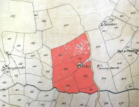
Map 4: Pikes Farm core land holding of 30 acres in the 1843 Tithe Map
| 1843 Tithe Map |
| a.r.p | |
| 153 | White Field |
|
|
| 154 | Field behind shed |
|
|
| 155 | Meadow | meadow |
|
| 156 | Upper Pasture | pasture |
|
| 157 | Field above garden |
|
|
| 158 | Homestead & Garden |
|
|
| 159 | Meadow under house | meadow |
|
| 160 | The Weir | meadow |
|
|
|
|
| c.30.0.0 |
Manor & Tenure: Abergavenny freehold but later acquired by Hopton as freehold.
Documentary evidence:
The property was let on a succession of long leases. The first of these appearing in documentary evidence was for 99 years from 1584 granted by Robert Hopton to William Prees Maddy and comprising a messuage and 38 acres at a rent of 10 shillings. Another 99yr lease was granted in 1674 at which time Walter Pikes Gent. was the tenant/occupier – giving his name to a previously un-named property.
The freehold interest was sold with their moiety of the Manor by successors of the Hoptons to the Jeffreys around 1693 and within 100 years the estate was starting to be broken up. The Pikes Farm freehold changed hands several times over the next two centuries.
A wealth of information is available regarding Pikes Farm from the Surveys of the area and from other documents held by various Record Offices and in other collections, most of which are accessible online through the Ewyas Lacy Study Group website. Its legal history is clearly shown back to 1584 whilst its construction history has been shown to pre-date this by at least some 100 years.
Upper Pen-y-Park
The house had been much altered and extended before being abandoned but appears to have been a longhouse probably late C17th-early C18th. In the yard are the remains of an old cruck framed barn, perhaps late C16th-late C17th, thought to be one of the Tithe barns of the parish. The property also sits on the old Ewyas Harold to Clifford route as it passed through the parish and just before starting to cross the Vagar Hill.
The property has been called Penparke, Pen y Park, Penn y Park, Pen Park , Penapark, Penny Park, Penpark, Penypark and Upper PenyPark in the Tithe.
Royal Commission 1931: The property was included in the Royal Commission Report of 1931 – Appendix 2, including notes, sketches
Listing 1971: Farmhouse Grade 11; Barn Grade 11
Tithe Map 1844:
By the 1844 Tithe Map, Upper Pen y Park comprised 53a 3r 38p, the landlord was Thomas Werae [Thomas Ware] and the occupier Sylvanus Watkins.
| 304 | rough | 32.2.28 |
| 305 |
| 2.2.38 |
| 306 |
| 3.0.5 |
| 308 |
| 3.2.4 |
| 309 |
| 0.1.3 |
| 310 | homestead | 0.1.5 |
| 311 |
| 8.1.31 |
| 321 |
| 3.0.4 |
|
|
| 53.3.38 |
Manor & Tenure: Held freehold from Hopton.
Documentary evidence:
The earliest mention is in 1546/7 Harley papers relating the Tithes in Ewyas Lacy where Penparke appears in a list of tithe barn locations. Its position on the old north-south route must have made it quite accessible.
In the 1566 survey, Howell Gwillym ap Rees holds the freehold of 12wa at 12d, equal to 36ea. The freeholder is confirmed in 1574 [HRO D4/47] paying 12d for Pen y Park but by 1624 Jane Prichard widow held the property
In 1653 Jane Prichard & John Powell prior occupiers, assigned or sold the freehold to John Smith & William Delahay. In 1653 Kentchurch Court papers [HRO AL40/1040 1600/15;] Penn y Park is one of three properties mentioned in an Indenture whereby the parties including John Probert and wife Elizabeth acknowledge the property to the use of John Smith and William Delahay. Jane Pritchard and John Powell the younger, former husband of Elizabeth Probert, formerly dwelt there.
By the 1665 survey [GRO MAN/A/151/0023] Ann Church widow holds free one messuage and lands formerly lands of Howell William Price [Howell Gwillym ap Rees] at 1s succeeded by Thomas Church by 1687 and 1702/5 survey.
A Mr Thomas and also Thomas Williams are names given as associated with the property in 1732 and 1740 respectively and the early Land Tax assessments omit the name of the landlord but give the occupiers as David Jenkins 1781 and Elizabeth Jenkins 1783. Philip Harris is mentioned in relation to the property in 1792 and James Dolward is given as landlord and widow Jenkins as occupier, in the Earl of Oxfords record of 1796.
The 1789 to 1810 Land Tax assessments still give no landlord but show widow Jenkins as occupier but by 1821 the landlord is Mrs Maddy and occupier Thomas Jenkins and by 1826 landlord of Penpark is May?n Ware and occupier still Thomas Jenkins. By 1838, Thomas Ware is given as the landlord and Thomas Jenkins remains in occupation.
Thomas Bevan agricultural labourer aged 45 was in occupation by the 1841 Census with his wife Elizabeth Bevan aged 50 and Joseph aged 10
Part 3: Farms of between 10 and 50 acres
Little Cefn and Old Mill
There are separate documentary references to Little Cefn and to Old Mill as individual properties, but by the time of the tithe map they are combined.
Royal Commission 1931: Not reported
Listing 1971: Not listed
Tithe Map 1844: The 1844 Tithe Map shows Little Cefn & Old Mill together at 46.75ea with Francis Lewis Bodenham as landowner and Thomas Phillips as occupier.
| 233 |
| arable | 2.1.7 |
| 234 |
| arable | 3.1.16 |
| 235 |
| arable | 0.3.14 |
| 238 |
| arable | 0.2.15 |
| 239 | Cae Garth | arable | 1.3.36 |
| 240 | Cae Garth |
| 1.0.32 |
| 241 | Little Cefn homestead |
| 0.3.2 |
| 242 |
|
| 3.3.36 |
| 243 |
|
| 2.1.2 |
| 244 |
| arable | 1.2.12 |
| 245 |
| arable | 1.2.27 |
| 246 |
|
| 0.3.24 |
| 247 |
|
| 1.3.28 |
|
|
|
| 23.1.11 |
| 249 | Old Mill homestead |
| 0.1.4 |
| 250 |
| arable | 0.2.33 |
| 251 |
| arable | 1.3.24 |
| 252 |
| arable | 1.1.21 |
| 253 |
| arable | 0.2.1 |
| 254 |
| rough | 1.0.5 |
| 255 |
|
| 2.3.27 |
| 256 |
|
| 3.1.26 |
| 257 |
| arable | 2.2.18 |
| 258 |
|
| 3.1.2 |
| 266 |
| meadow | 4.1.16 |
| 267 |
|
| 0.0.8 |
| 268 |
| rough | 1.0.7 |
| Total |
|
| 46.3.10 |
Manor & Tenure: Little Cefn was held freehold from Hopton and Old Mill was an Abergavenny copyhold. They merged prior to the Tithe Map
Documentary evidence:
Little Cefn
The 1566 survey gives Rice Griffith holding freehold 5 Welsh acrea [15ea] of land at a rent of 5d. By the survey 8 th James [1610] this land was divided between the 4 daughters of Rees Griffith.
By 1665 David Smyth, Hugh Charles & Josias Price held freehold one messuage and lands late of Rees Griffith at 5d. David Smyth pays 3d, Hugh Charles 2d & Josias sold his share. By the 1705 survey the two shares were held by Thomas Smith and Charles Charles son of Hugh. Thomas Smyth in his will [NLW BR1711/112] dated 1711 states he had bought “cevens lands” from his father David and Clement Williams and left it to his son David.
By the 1776 Land Tax, David Pritchard is given as landlord and Thomas Williams as occupier. In her will of 1782, a Mary Roberts of unknown origin [NLW 1782/43] said she was owed 40s by Thomas Williams of Little Keven.
In the 1779 will of David Prichard of Little Cefn, he says he lately acquired the property from James Harris. It was left to his son David.
1779-1869 HRO AB100/3/1-17; ELSG tg_mic_0024; Deeds to Little Keven and Old Mill; plans of Old Mill lands and Carpenters Arms alias L Keven 1841
David Prichard, or another son David, is given as the freeholder in the 1783 to 1798 Land Tax assessments. In the early 1800s survey the land is shown as Mr William Prichard, at the 1802 election a David Prichard of Peterchurch is given as a freeholder, David Prichard again in the 1810 Land Tax and David Prichard of Cusop in the 1818 election. Over this period, occupiers included John Pugh 1790, James Prichard 1802 Poll Book, Timothy Howard 1810 and James Price 1818 Poll Book.
By the 1821 and 1826 Land Tax, Samuel Taylor is shown as owner/occupier.
1833/41 document HRO AD 57/18 records Little Cefn in a transaction between David Jones former of Dorstone & Martha his wife and James Beavan carpenter of Clifford and Hannah his wife, daughter of David & Martha.
The 1838 Land Tax gives Jas Beavan as owner/occupier of Cevan. Then in 1840/41 several transactions took place involving Little Cefn and Old Mill. Old Mill buildings and 21 perches is shown as leasehold in the 1841 sale details held by Mr Jas Bevan from Thos Jones on a 1yr lease from Dec 1840. It was purchased by Bevan from Thos Jones in March 1840.
In June 1841 two lots were offered for sale by Bevan - Lot 1: The Carpenters Arms or Little Keven Farm; Lot 2: Old Mill building.
The 1841 Census gives William Davies aged 40 farmer in occupation of Old Mill with Little Ceven occupied by James Beven aged 54 carpenter, Hannah 47, Mary 10, Mariah 10, Caroline 11, Frances 5 and Harriett aged 3
Old Mill
The 1624 survey gives John Smith as copyholder of 12 customary acres and 13 acres “quond concess Lodovico Gilbert”. There is reference to Phillip John Lewis holding possibly for 21 yrs from 1622 at a rent of 3s and an area of 24 ea. To the west is Keven Baugh [Cefn Hill], to the east the Llanrosser/ME lane, to the north lands of the heirs of Reece Giffithes [Little Cefn] and to the south part lands of David Howell Probert [Upper Lower House] part Katheryn Whitney [?Court Farm, Craswall]. It is clearly Old Mill.
The entry adds it is thought that part of this copyhold lies on the other side of the lane in the occupation of [ ] Gilbert and that an “outhowse” near unto the common gate was built on the land.There is no reference to a house – and a plan of the land [map 4] shows a house outside the land suggesting a separate holding.
The 1708 Abergavenny papers HRO J91/1 show David Smyth holding the copyhold of 12 Welsh acres at 3s which he assigned in 1739 to his daughter Anne now wife of James Harris, and in 1767 she assigned it into their joint names. In 1776, Thomas Harris is given as the occupier and in 1778 the copyhold is assigned to Edward Allen perhaps as mortgagee.
1779-1869 HRO AB 100/3/1-17 Deeds to Little Keven and Old Mill [ author’s note – to be checked ]
The early 1800s survey shows Old Mill land as in the possession of the late James Harris and comprising 21a 3r 32p
| 33 | Pasture | 5.1.30 | 257 &258 |
| 34 | Pasture | 3.2.20 | 256 |
| 35 | Pasture | 2.2.31 | 255 |
| 36 | Rough | 1.2.4 | 253 & 254 |
| 37 | Arable | 1.1.11 | 252 |
| 38 | Arable | 1.3.6 | 251 |
| 39 | Arable | 0.1.36 | 250 |
| 40 | Meadow | 3.2.31 | 266& 267 |
| 41 | wood | 1.1.23 | 268 & 269 |
| Total |
| 21.3.32 |
|
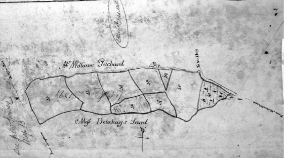
Map 5: Old Mill
In the Land Tax assessments, James Harris is given as owner/occupier in 1783 and William Harris from 1789 to 1821. William Harris is given as a parish freeholder in the 1818 Poll Book. Occupiers included Jas Philips 1810 and Thomas Jones 1821.
The 1826 Land Tax for Auldmill gives Henry Allen as the landlord and Thomas Jones as occupier. The copyhold is subsequently assigned but not by Henry Allen so it may reasonably be assumed that he had acquired the freehold interest by now. [ author’s note; more research needed to discover what happened to Allen’s freehold ]. An Elizabeth Jones of Old Mill died in 1836 aged 13.
By 1837 The Old Mill Ground copyhold was held by Thomas Powell of Clifford Esq. The 1838 Land Tax gives Henry Allen as landlord and William Jones as occupier. Thomas Jones as copyholder, sells to Mr Bevan in 1840 who re-offers it for sale in 1841. The 1841 Census gives William Davies aged 40 at Old Mill.
As note above, the 1843 Tithe Map shows Little Cefn & Old Mill combined.
Great Cefn
The early references are in the Old Kates entry below. They only refer to one messuage. Old Kates has a cruck framed barn and a very old cottage. Great Cefn has a barn dated 1677 but the current house could well be later from its design/construction.
The Great Cefn Tithe map land holding had an access off the common but access routes only, with no land holding, facing on to the road. That land remained with Old Kates. The holding probably remained as one until some time after the 1705 survey but was divided before the earliest Land Tax records.
Royal Commission 1931: The property was included in the Royal Commission Report of 1931 – Appendix 2, including notes, sketches
Listing 1971: Farmhouse Grade 11; probably C17th; two cell plan; Barn Grade 11; C17th, 1677 on part
Tithe Map 1844 :
By the time of the1843 Tithe Map the Rev'd Hugh Hammer Morgan and Walter Maddy were still landlord and occupier respectively. The land area was 39a 3r 17p.
|
|
|
| a. r. p. |
| 179 |
| arable | 2.0.25 |
| 180 |
| arable | 2.0.9 |
| 181 |
| arable | 3.3.5 |
| 182 |
|
| 0.1.18 |
| 189 |
|
| 3.0.7 |
| 190 |
|
| 3.2.0 |
| 191 |
| arable | 3.1.24 |
| 192 |
|
| 2.0.36 |
| 193 |
| arable | 3.0.23 |
| 194 |
|
| 4.3.2 |
| 194a |
| arable | 1.3.26 |
| 195 | Homestead |
| 0.1.19 |
| 196 |
|
| 5.1.2 |
| 231 | The Linney | arable | 4.1.10 |
| 232 |
|
| 0.2.15 |
| Total |
|
| 39.3.17 |
[ author’s note: There is some question about fields 179-182 + 193 not being part of Great Cefn. They are now Upper Llanrosser . Not resolved .]
Manor & Tenure: There is some reason to think that Great Cefn and Old Kates were initially held freehold as one property from the Hopton Manor.
Documentary evidence:
The 1795 Land Tax entry gives the landlord as the Rev'd Mr Hopton with Thomas Williams as occupier. Subsequent entries show landlords as the late Rev'd Hopton in 1798, Mr Bough 1810 & 1821, Mr Webster 1826 and the Rev’d C Morgan in 1838. Occupiers included John Smith 1798 and Jas Phillips 1810 but by 1821 through to 1838 Walter Maddy was in occupation.
The 1841 Census for Great Cefn also gives Walter Maday farmer as the occupier, then aged 56 with Martha 30, James 10, Stephen 8, Mary 6 plus Elizabeth Wood aged 60. Martha died in 1842 aged 32.
The 1841 sale of Little Cefn HRO AB 100/3/10 gives the land to north of L Keven as Mr Maddy's tenancy.
Sunnybank
Sunnybank [Tithe fields 204 and 206] appears to have originally been built as a two roomed unit, one room comprising living space with a fireplace and the other an adjoining but separately accessed, cow shed. It was probably built no later than the late C17th and maybe earlier perhaps as a hill bothy rather than a permanently occupied house.. At a later date an additional store or animal area was built. Unusually, the building remained like that through to modern times.
Royal Commission 1931: Not reported
Listing 1971: Not listed
Tithe Map 1844:
At the time of the Tithe Map Sunnybank and the field nos 148-150 were owned and occupied as one by Thomas Jones and Thomas Stevens .
Map 6: Extract from the Tithe Map 1844
The Tithe map gives Thomas Jones as the owner and Thomas Stephens as occupier of 38 acres 2 rood 27 perches.
|
|
|
| a.r.p |
| 148 |
|
| 0.1.32 |
| 149 |
|
| 3.2.37 |
| 150 |
| pasture | 19.0.36 |
| 204 | Sunny Bank Meadow | meadow | 8.0.12 |
| 206 |
|
| 7.0.30 |
|
|
|
| 38.2.27 |
Manor & Tenure: Not reported
Documentary evidence:
At the Tithe map, fields 148-150, known as Cae Cydrech were owned and occupied with Sunnybank . It is not clear if it ever included a separate dwelling although there are some stone remains, but it is referred to in documents back to 1604 and was probably held freehold by at least the mid C16th.
The 1604 will of Jenkin Madye, who was then living at Pikes Farm, shows that he was also farming the Sunnybank land and Kay Kiddrigh. The Sunnybank fields he called Kay yr Lloweddroge, Kay Lloyde and Kay Croone. He left his property to his mother and wife and then to his nephew Thomas Powell Maddy.
The 1653 survey detailing the 1584 letting of Pikes Farm to William Prees Maddy, also refers to adjoining free land late of William Prees Maddy called Kydrich.
The 1665 survey includes an entry which could be Sunnybank. Walter Pikes held freehold for 5d from the Hopton Manor, a messuage and divers lands formerly William Powell Maddy. The rent would suggest an area of 15 acres which is equivalent to Tithe fields 204 and 206 around Sunnybank. Perhaps William had been granted the property from Thomas Powell Maddy his brother? However this freehold is not shown in 1705.
The Pikes Farm lease in the 1705 survey says that William Pikes held the Sunnybank fields. In 1713, possibly the same William Pykes took a lease on a property near Arthur’s Stone, perhaps when he moved from Sunnybank?
Addendum: Feedback to our website from from PJ Pikes 22/6/2024
The Pikes Farm lease in the 1705 survey says that William Pikes held the Sunnybank fields. This may be my 6th great-grandfather, William Pikes, yeoman, of Michaelchurch Escley, who took a 99 year lease on a dwelling called the Chappell near Arthur’s Stone in Dorstone in 1713,perhaps when he moved from Sunnybank.
A Henry Pikes, gent, was buried in Ewyas Harold in 1719. This may well be the Henry Pikes on your pages.
Prior to 1775 the property was in the tenure of James Morgan and by 1776 Hugh Bevan held the freehold .
The 1776 and 1783 Land Tax refers to the property as Ezlands, and from 1776 to 1821 the landlord is shown as Hugh or Sarah Beavan or their son Samuel. It is shown as “late” Hugh Beavan in 1826 and owner occupied by a Mr Jones in 1838. Beavans were in occupation for many years but in 1821 Timothy Howard was the occupier with William Williams in 1826. Timothy Howard also occupied the Birches and from 1838-45 a William Williams occupied Tyn-y-Gwynt adjoining.
The 1818 election returns confirm Hugh Bevan gent of Clifford as a parish freeholder of a house and lands and Timothy Howard in occupation.
In 1833 the property was sold for £350 by the Beavan estate to Thomas Jones of Poston, Gent . [who owned Birches in 1826] . The property is described as follows:
“messuage or cottage & lands with the appurtenances now and for many years past commonly & known by the name of Sunny Bank or otherwise the Little Pikes lying together and containing by estimation 15 acres _ _ _ from River Escley on the south to the Hill or Common called the Vagar hill on the north having a highway leading from Llanrosser to the said Hill or common on the west and lands called the Pikes lately belonging to Eneas Walter deceased & now to [blank] Woodhill? on the east part or side thereof and also all that piece or parcel of rough pasture land called Cae Cydrech containing by estimation 20 acres & usually held & occupied with the said cottage & lands called Sunny Bank having lands of Henry Allen Esquire & lands belonging to the Greegloye Farm [Griglands] on the south & west & the said Hill or common then called the vagar hill on all other parts or sides thereof”
all in ME
formerly in the tenure or occupation of James Morgan afterwards of the said Hugh Beavan since of Timothy Howard & William Williams successively & now of W Thomas Jones.”
The 1841 Census gives Thomas Stephens farmer aged 26 as the occupier of Little Pikes with his wife Phiobey 20, Elizabeth 2 and William 6 months . Interestingly Sunnybank is also entered as uninhabited. By 18 71 , Thomas Stephens had moved – plus wife and by then five children! - to larger accommodation at Lower Llanrosser where his (?) father Francis had lived.
Lower Pen y Park
Royal Commission 1931: Not reported
Listing 1971: Not listed
Tithe Map 1844 :
By the 1844 Tithe Map, the landowner of Lower Pennypark had become the Rev'd Pierepoint Taylor and the occupier was William Bishop.
| 314 | Pasture | 10.3.14 |
| 315 |
| 0.1.33 |
| 316 | Meadow | 5.2.28 |
| 317 |
| 0.0.16 |
| 1087 | Meadow | 3.0.27 |
| 1088 | Arable | 3.1.29 |
| 1089 | Arable | 3.2.25 |
| 1090 | Arable | 2.3.16 |
| 1091 | pasture | 5.0.12 |
| Total |
| 35.1.5 |
Manor & Tenure: Abergavenny copyhold? /leasehold Whilst in 1687 the tenure was given as copyhold, by 1701 it was being called leasehold, although the rent remained the same. Copyhold rents are fixed and not changed on assignment. A leasehold tenure would undoubtedly have commanded a higher rent than one first recorded in 1590, so there must be some doubt as to whether this tenure did change. Around 1800 [D1583/208 1800/28;] Pen y Park was still referred to as being let but in 1858 it was again referred to as copyhold and the freehold sale in 1920 also referred to a copyhold tenure.
Documentary evidence:
A Richard Lloid [Richard Lloyd] must have held this farm some time prior to 1590. It was part of the Abergavenny Manor and at that date, land called Tire Richard Lloid was held copyhold by David Thomas gent at 3s 6d. At 3d per Welsh acre for copyholds, this was equal to 14 Welsh acres Abergavenny HRO B56/6
The 1624 survey gives John Colstock holding a messuage and 14 Welsh acres also given as 30 English acres, called Tyre Richard Lloyd [in tenure of Thomas Smith] at a rent of 3s 6d. It was bounded on the south on copy lands of John Delahay [Pucca copy] & part on freehold of John Powell [in Peterchurch]; on E part the free land of John Powell and part freeland of Thomas Jennings and part land of Thomas Delahay; on W lands of Thomas Jennings [must be Tithe 312] of Jane Prichard [UPP] and of Thomas William Price [kitchen fields including Tithe 320]; on N upon the lane adjoining Snowdle Parke pale. This is clearly Lower Pen y Park.
The 1687 survey gives Jane Powell now Phillip David holding the copyhold and this time the field names are given:
house, outhousing, gardens with folds 1 acre
meadow by house 6 acres
lower meadow 5
Kae yr Garne 5
Kae Pant 3
Kae Pwll 4
Kae Klarketh 3
Kae Pwll corn & brome 4
Kae dwch law yr Tyr in two parts 4
This totals 35 acres, the same as the Tithe Map and was bounded N by lane at Snowdale Park; E lands of John Prosser; S ground called Old Hay [Lay or Tay] part of the lands of Thomas Delahay; W widow Church lands [UPP].
The 1701 survey suggests Phillip David was holding a leasehold interest from 1687 rather than a copyhold, comprising one messuage with 9 acres, also given as 38 acres, at 3s 6d. In 1732 [ GRO MAN/A/151/0032 1700/40] Thomas David of Craswall holds the lease but the land reverts to the 30 acres of the 1624 survey.
By 1740 Abergavenny papers HRO D.1583.4.22,23 show a Lease for lives perhaps the same Philip David late of Clodock, Officer of Excise, now of Preston Lancs, is given holding the 30 acres on lease, comprising a Messuage garden and orchards, late in occupation & lease to Thomas David. By 1775 [Abergavenny papers D1583/1/1] Philip David junior held the property then inhabited by Thomas Jones & Margaret Mabb.
The early 1800s survey gives [Lower] Pen y Park as late Philip Davis comprising 34a.
| 1 | House & meadow | Meadow | 6.2.16 | 315-317 |
| 2 | Middle meadow | Meadow | 3.2.6 | 1091 |
| 3 | Lower meadow | Meadow | 2.2.35 | 1087 |
| 4 | Tumpy piece | Arable | 7.0.19 | 1088-1089 |
| 5 | Piece of arable | Arable | 1.2.4 | Pt 1090 |
| 6 | Far piece | Arable | 1.1.0 | Pt 1090 |
| 7 | Rough piece | pasture | 11.1.5 | 314 |
| Total |
|
| 34.0.0 |
|
Map 7: Lower Pen y Park
Land Tax records from 1776 to 1838 show the landlord as Mr Davies/Davis with Phillip Davies given in court rolls HRO J91/3 in 1838. Occupiers included widow Smyth 1776, John Jones 1783, Dr Exton 1791, Simon Exton 1798, Richard Jones 1810 and Thomas Jenkins 1821-1838.
The 1841 Census gives Thomas Jones agricultural labourer aged 45 as occupier with Elizabeth 45, Lydia 15, Hanah 12, Elizabeth 10, Daniel 8 and Enock aged 11 weeks.
Old Walls & Castle
These two properties only came together shortly before the Tithe Map and so their histories before that are considered separately.
Royal Commission 1931: Not reported
Listing 1971: Not listed
Tithe Map 1844 :
The Tithe Map has Castle & Old Walls together 35 a [OW 23a], landlord Richard Williams tenant David Lewis.
| Tithe Map |
|
|
|
| 62 | Old Walls | Rough | 3.1,22 |
| 63 | Old Walls |
| 2.2.6 |
| 64 | Old Walls |
| 1.1.25 |
| 65 | Old Walls |
| 4.2.23 |
| 66 | Old Walls | Arable | 3.1.23 |
| 67 | Old Walls | rough | 3.0.4 |
| 68 | Old Walls |
| 3.2.20 |
|
|
|
| 23.0.3 |
|
|
|
|
|
| 115 | Lower Cae Pant |
| 2.1.19 |
| 116 | Middle Cae Pant |
| 2.3.33 |
| 117 | Middle Cae Pant |
| 0.2.35 |
| 118 | Upper Cae Pant |
| 4.1.2 |
| 128 | Lower Cae Pant | pasture | 2.1.19 |
|
|
|
| 12.2.28 |
|
|
|
|
|
|
|
|
|
|
|
|
|
|
|
Manor & Tenure: part Abergavenny held freehold by Hopton and part freehold from Hopton
Documentary evidence:
Old Walls
Documents suggest part of Old Walls/Price Putta plus the Cae Pant fields were held together and the other part of Old Walls was held separately. OW/PP was held with Castle by the Tithe Map and the Cae Pants were by then part of Upper Llanrosser
Part OW/PP appears in the 1653 survey and this suggests it was a Hopton leasehold with Hopton holding the freehold from Abergavenny. There is no certain evidence of the latter but there is a possible Hopton freehold at 6d for “land”. 6d is 6Wa or 18EA. There is a 1585 99yr lease with OW comprising 9.5a and PP 9.5a. By 1665 there was a new lease but no area is given and in 1750 the area is given as 38 acres. This is close to the Tithe Map areas of 23a for OW and 12.5 for CP.
The other part of Old Walls was held freehold from Hopton for 6d although the area [23a total from Tithe less 9.5a from leasehold] would be around 13.5a so the rent is a bit more than 1d per Wa. There is a suggestion that this freehold became a leasehold even by 1610 but in support of the argument – John Colcombe held the freehold and was also noted as adjoining New House so he must have held Cae Pants as well; after him they were held by the Philpotts.
So whilst JC may have held the long lease of part and freehold of part from Hopton, the Philpotts certainly did, so the whole of OW and CP were farmed together.
Part Old Walls plus Cae Pant fields
1624 there is a Hopton entry of 6a/6WA of land freehold from Abergavenny to the late William Smith who must have been occupier. This rent is relevant to an 18ea holding but there is no other link to the property. Also, it must have been sold later to end up with Allen by 1776 – possibly by Jeffries around 1770’s along with numerous other purchases in the area.
The 1585 1653 Survey of sequestrated Hopton properties probably held freehold from Abergavenny includes messuages called Price Putta with Cae Garw adjoining messuage 4a: Price Pitta pasture/wood 2a; Gworlod dan y Ty meadow 3.5a. ie 9.5ea. Held with Cae’r Panta Isa, Ucha and Cenol at 9.5 ea. Now or late in occupation of Marcus Gilbert; Leased by Robert Hopton 11 th June 1585 to Phillip Thomas Prees Maddy for 99 yrs at £1 5s, 20s heriot. An old building/house may have stood at the common/top end of Old Walls.
From 1619 document on New House [K10/4] John Colcombe is shown as in occupation of the Cae Pants fields which adjoin New House. This may refer to actual occupation rather than “ownership” as the field appears to have remained in leasehold ownership of the Philpotts.
1690/1700: Mrs Philpotts now Lady Hamilton held property at £1 5s
1705 Survey: Nicholas Philpotts holds the lease made between Thomas Wyndham Esq [held Estate briefly around 1670s] & Nicholas Philpotts grandfather to said NP, one messuage late in possession of Thomas Jones for 99 yrs for lives at £1 5s, 30s heriot.
Land – Thomas Prosser on West, Vagor common on North, Thomas Miles on East & river on South [almost certainly Old Walls] plus another parcel bounded with river on north, Thomas Delahay on east & south, Thomas Smith and John Powell on west & east[?]. This is almost certainly Cae Pants.
A supplement adds that the messuage & buildings are ruinous. There was a building on Old Walls and the ruinous messuage could be this.
Other part of Old Walls
The 1665 survey gives Nicholas Philpotts paying 6d for a tenement and divers lands formerly John Colcombe. Whilst in a freehold survey, the entry does not carry the same wording as others confirming it was held freely. There is a further comment that by a 1610/11 survey it appears that the land and tenement was formerly held by Indenture [ie was leasehold?] from Hopton and the services are extinguished and only the rent reserved. The meaning of this is unclear.
Also, the rent suggests 18ea whereas Old Walls leasehold was 9.5ea so the balance from the Tithe total of 23ea would be only 13.5, which is not a good fit.
The 1705 survey gives one messuage and land formerly held free by John Colcombe at 6d and now held on lease by Michael Philpotts Esq.
Sometime after this, the two parts of OW plus the CP fields are held together because in 1750[?] Jeffries surveys shows James Jones holds Philpots land of 38 acres. This is close to the Tithe areas of 23 for OW and 12.5 for CP but accepting that CP has increased from 9a in 1585 to 12.5a – perhaps by clearing woodland enlarging Tithe 118?
By 1776 Land tax the Allens had Pensyl with CP; CP was separated off by 1798. The Allens probably acquired the Hopton freehold at 6d from Jeffries around 1770s, kept CP which was to go into U Llanrosser and sold OW
1781 Land Tax has a Jones at Old Walls
1783 Land Tax has landlord Mr Thomas, tenant Walter Jones and tax of £1 5s 4d.
1789 &1810 Land Tax had landlord Mead & Thomas, tenant Jas Phillips and tax £1 3s 4d
1796 Earl of Oxford’s Tithes had late Walter Jones, no proprietor, occupier John Phillips, area 11.5 acres tithe 0.17.0
1841 Census no entry
Elizabeth Beavan of Old Walls died 1845 aged 62
Castle
Lack of survey entry in 1701 and 1711 suggests the property had not been built and the land not taken from common then. In 1751 a new lease date suggests the house was already built by then. 1826 documents suggest about 4 acres was enclosed from the common.
The area starts at 10a and also at 1826 despite comment about the 4 acres above. By 1844 it was 13a.
Rent starts at 1s and still at 1s in 1826 lease although an 1826 rent given of £10 is perhaps a sub-letting. By 1920 this was £14 but the lease from Abergavenny at 1s must have ceased and the sub-letting taken by Abergavenny.
Royal Commission 1931: Not reported
Listing 1971: Not listed
Tithe Map 1844:
Owner Richard Williams occupier David Lewis; Area 35a 0r 24p including Old Walls, 13a 0r 30p for Castle alone
| Tithe Map |
|
| Area |
| 43 |
|
| 1.3.22 |
| 44 | garden |
| 0.1.27 |
| 45 |
|
| 3.1.19 |
| 46 | homestead | 0.1.32 | |
| 47 |
|
| 0.3.11 |
| 48 |
|
| 2.0.36 |
| 49 |
|
| 2.1.35 |
| 50 |
|
| 1.0.16 |
| 51 |
|
| 0.1.32 |
| Total |
|
|
|
Manor & Tenure: Abergavenny
Documentary evidence:
1701 Abergavenny survey shows no leasehold at 1s
1711 Abergavenny survey has no matching entry
1751 from 1660-1779 Abergavenny Abstract of Leases MAN/A/151/0032 1700/40; 2 nd Dec 1751 demise to Richard Greenow of Dorstone husbandman, cottage and garden with 10 acres now in his possession on the common or waste called the Vagor Hill and bounded on all parts by the common; for lives of three sons Richard 7, Thomas 5 & James 1 yr; rent 1s
1739-1790 Abergavenny leases MAN/A/151/0033 1700/40; gives a James Grenow, cottage and 7a 1r 25p. James and Richard’s names are written as well.
Land Tax
1776 landlord Mr Morgan; occupier James Prichard
1783-98 landlord Henry Morgan; occupier Jas Prichard
1798 will of Henry Morgan [NLW BR/1798/11] recites an ancient messuage left to son Thomas in tenure/occupation of James Prichard. The 1802 Pool Book gives Thomas Morgan and John Phillips as parish freeholder and occupier respectively.
The early 1800s [Abergavenny] survey [copyholds and leaseholds GRO D1583/208 1800/28] gives the Castell 10a 1r 29p with plan; held by James Greenough; Tithe nos pt 43, 45-51.
| 32 | Meadow | 7.1.25 | 46-51 |
| 33 | Pasture | 2.2.0 | 45 |
| 34 | arable | 0.2.4 | Pt 43 |
| Total |
| 10.1.29 |
|
Map 8: Castle
Land Tax
1810 landlord Mr Morgan; occupier Thos Phillips. These two shown as parish freeholder and occupier in 1818 Poll Book
1826 from 1760-1862 Agents Book GRO MAN/A/151/0040
Leasehold. Lease Granted 29 Sept 1826 to Henry Morgan of Newton Court
for the Lives of John Watkins (son of Wm Watkins of the “Middle Cwm”) then aged 9, Benjamin Lewis (now of the Lower Maescoed, Laborer) then aged 7, and John Jones (son of John Jones of “Llanon” St. Margarets, Gent) 2 years .
called the “Castell” and now in possession of James Farr and Henry Lillwall.
About 4 acres enclosed out of Common - now in 5 fields
1826 Abergavenny survey of leases GRO MAN/A/151/0035 1819-1861,1800/45; property called Castell leased on 29 th Sept 1826 to Henry Morgan of Newport at 1s, cottage stable fold garden & land, 10a 1r 22a, on Vagar Hill, now in occupation of Henry Morgan or undertenant; originally granted 1751 to Richard Green for lives of three sons and reverted to the Lord on the death of James.
Land Tax
1826 landlord Thomas Morgan; occupier Phillip Jones
1826 Abergavenny papers GRO D1583.233.5 Castle rent of £10pa received from Philip Jones of cottage & lands called Castle, the lease of which expired on the death of James Greenow and due 25 March 1826
1841 Census Casteel gives David Lewis farmer aged 25 in occupation with Elizabeth 25 and Esther aged 3.
1858 Abergavenny list of copyholds GRO MAN/A/151/0039 1800/48 shows Castle Hill held by James Farr at 1s. However this is probably not Castle , which was leasehold
Mid 1800s Trafford papers show that the Michaelchurch Estate bought a property called Castle
1920 Abergavenny sale includes Castle Farm old cottage and building 14a 0r 5p tenant Mr Charles Price at £14pa. Tithe field nos 43, 44, 45, 46, 47, 48, 49, 50/51 extended. Sold to Charles Price at £500 to include Spring Castle .
Tyn y Gwynt
Tyn-y-Gwynt has been the subject of dendrochronology dating. It remains an excellent example of a cruck framed hall/long house and has been dated as early 1500s. Dendro date range of cruck frames 1521 to 1537
Royal Commission 1931: The property was included in the Royal Commission Report of 1931 – Appendix 2 notes, sketches
Listing 1971: Farmhouse Grade 11; probably late C17th; 2 cells extended to form longhouse; cruck framed; Barn Grade 11; probably C17th
Tithe Map 1844:
The Tithe Map gives the landowners as Ann & Merean Prosser and occupier William Williams. The area was 34a 2r 35p.
| 1843 Tithe Map |
|
| |
|
|
|
|
|
| 212 |
|
| 2.0.33 |
| 213 |
|
| 0.2.28 |
| 214 | Homestead |
| 0.1.22 |
| 215 |
|
| 4.1.14 |
| 216 |
|
| 6.0.10 |
| 218 |
|
| 0.2.18 |
| 218a |
|
| 3.1.32 |
| 282 |
|
| 1.2.26 |
| 283 | Orles |
| 6.3.19 |
| 284 |
| arable | 1.2.38 |
| 285 |
| arable | 2.0.10 |
| 291 |
| arable | 1.3.0 |
| 292 |
| arable | 1.2.16 |
| 293 |
| rough pasture | 1.1.9 |
|
|
|
| 34.2.35 |
Manor & Tenure: Abergavenny
Documentary evidence:
It was held freehold from Abergavenny. The 1624 survey gives David Howell Probert paying 10d for a messuage and 10 Welsh acres “whereof parcel is called Tire Phillipp Bean & Tynn Gwynn. His occupation is supported by another entry in the survey where he is given as adjoining part of Old House.
Old House was held in 1566 by Henry Howell Gwillim Bean so perhaps three generations earlier, Phillipp Bean was at Tyn-y-Gwynt and his brother Gwillim was at Old House.
By 1687, Mary Probert is given as adjoining Old House.
The 1701 survey does not have a matching entry but does show John Probert paying 1s 1d for a messuage and certain land. The 1705 survey gives Eustance Probert, formerly David Harry Powell, occupying Tyn-y-Gwynt and by 1712, Richard Shaw holds the freehold let at 1s 1d, formerly James Probert. Richard Shaw was Mary Probert.s grandson.
This freehold tenure pattern is thought to be correct but the change in rent cannot be explained unless the land area was amended. However, there is no evidence for this. The tenure pattern is reflected in Upper Lower House where the Proberts also held the freehold interest.
The Land Tax shows Thomas Williams and then Mrs Williams as landlords from 1783 to 1790 with James Williams and then William Williams as occupiers. From 1791 to 1821 John Smith is given as owner/occupier [& in 1802 & 1818 Poll Books] although Samuel Jones occupies in 1810. By 1826 Elizabeth Smith is the landlord [died 1838 aged 75] with John Smith as occupier but by 1838 Tinagwynt is owner/occupied by William Williams.
The 1841 Census gives Tinagwint as occupied by William Williams farmer aged 45 farmer with Ann 45 and Elizabeth 10.
In an 1843 Abstract of Title [HRO L79/12; ELSG tg_mic_0129;] Twyn-y-gwint or Ty-ycha is owned freehold by Rev'd Thomas Prosser. He and his wife Ann died in 1843 leaving the property to daughters Mary Ann, Sarah Forrester and Merea.
Old Kates
It appears that Old Kates with its messuage was originally held with land which was to become Great Cefn.. At the Tithe, they had a combined area of 73 acres or 24 Welsh acres. There are early records of a freehold with a rent of 1s 10d ie 22 Wa/66Ea with names that fit later data. Old Kates may well have taken its early access from the Cefn Hill common across the land to become Great Cefn. The missing 7 acres might have been land enclosed from the Common by 1840.
Royal Commission 1931: The property was included in the Royal Commission Report of 1931 – Appendix 2; notes, sketches
Listing 1971 Farmhouse Grade 11; C17th; 2 cell plan; Barn Grade 11; perhaps C16th or C17th; cruck framed
Tithe Map 1844:
By the Tithe Map, James Baker is shown as the landowner but Thomas Wood is still in occupation. The land area is
| 176 | arable | 2.1.8 |
| 197 | arable | 1.3.21 |
| 198 | arable | 3.3.5 |
| 199 | arable | 2.2.3 |
| 224 |
| 3.1.25 |
| 225 |
| 2.3.37 |
| 226 |
| 4.1.24 |
| 227 |
| 0.1.32 |
| 228 |
| 2.3.31 |
| 229 |
| 3.1.34 |
| 230 | arable | 1.3.9 |
| 248 | pasture | 3.1.34 |
| 269 | arable | 0.1.7 |
| Total |
| 33.2.30 |
Manor & Tenure: The tenure was freehold from the Hopton Manor
Documentary evidence:
In 1566 Thomas Gilbert held freehold one messuage and 22 wa [66ea] in Michaelchurch Escley then in the tenure of Morgan Williams, at rent of 22d
By 1665, Thomas David held the freehold described as one messuage and lands late the lands of Lewis Gilbert gent, at 1s 10d
By the 1705 survey, Thomas Smith held freehold one messuage & lands late of Thomas David and formerly Lewis Gilbert. Although the rent was 20d rather than 22d, it would appear to be the same holding.
The 1705 Survey has another entry, Sir Thomas Morgan Bart’s copyhold dated1698, which suggests that Thomas David and now Thomas Smyth held the land to become Great Cefn. Also a lease on Tithe field no 200 called Callen, [previously Lloyne mabbe cidda], recites Thomas David being in possession and also holding the land to the south east.
Thomas David, husbandman, died in 1710 leaving his wife Catherine as widow – it is possible that Catherine was ‘Old Kate’. Thomas Smith, who died in 1711, also held Little Cefn.
The single holding of this property had been divided by the earliest Land Tax records. These show an entry given as a tenement, with no name but with good owner continuity and ending up in 1838 with Thomas Wood as occupier – as per the Tithe map. Mr or Mrs Francis are given as landlord between 1776 and 1838, the extent of the records. Occupiers changed regularly -
1776 Samuel Jones
1783 William Williams
1789 & 90 & 98 Richard Havard
1810 John Williams
1821 William Symonds
1826 John Pary
1838 Thomas Wood
A William Williams died in 1833 aged 5 months , Thomas Wood in 1835 aged 3 and John Woods in 1840 aged 85, the last two described as of Kates Place .
1841 sale particulars of Little Cefn confirmed Thomas Wood’s occupancy of Old Kates and in the1841 Census the property is called Old Cates and Thomas Wood farmer aged 50 is in occupation with Mary 45, Elizabeth 15, Harriett 10 and John 5.
Birches
Royal Commission 1931: Not reported
Listing 1971: Not listed
Tithe Map 1844:
The 1844 Tithe Map gives John Motley as landowner/occupier on 22a 0r 37p.
| 201 |
| 0.2.17 |
| 202 | Cae Garw | 4.2.23 |
| 203 | Cae Garw | 4.0.17 |
| 207 | Homestead | 0.3.0 |
| 208 |
| 1.3.7 |
| 209 | Plock | 0.2.2 |
| 210 | wood | 3.1.9 |
| 211 |
| 6.2.2 |
| Total |
| 22.0.37 |
Manor & Tenure: No data
Documentary evidence:
The first document regarding The Birches is a freehold sale in 1793 of two of the fields with a given total area of 20.5 acres [areas of Tithe nos 211 at 6.5a and 201-3 at 9.1.17 respectively but these add to only 15.3.19 from the Tithe]. The sale was to Eneas Walter of Clifford yeoman, who, it might be reasonably assumed, already held the rest of the property, the house and fields nos 207-10. The house sat right on the edge of the Vagar Hill common and, even at the Tithe Map date, took its access directly off the common.
The two fields had previously been part of Pikes Farm but there is no known documented history to the house and its land. It is possible that the original house was first constructed around this time but it would also seem quite possible that there was an older cottage on the site alongside the common.
However, prior to this purchase by Eneas Walter there is no reference in any documents that appears to relate to the earlier 6.25 acres with or without a house.
The history from 1793 is recited is numerous privately held documents. They do give rise to some anomalies. Particularly the apparent confusion that the sale of land by the owner of Pikes Farm, was a sale of the farm itself. The land is referred to as the Pikes and Little Pikes but this latter name has also been given to Sunnybank.
The 1793 sale was between Henry Allen of Talgarth, Brecon Esquire, eldest son and heir at law of Edward Allen late of The Lodge (Brecon) Esquire deceased and Eneas Walter of Clifford yeoman. The consideration was £280 for the fee simple. The land comprised
“all those two closes pieces or parcels of pasture and woodground one whereof is called the Birches and contain ten acres & three quarters Statute Measure more or less & the other called Cae Garret & contains nine acres & three quarters Statute Measure more or less which said two closes were formally and until the Execution of these presents are part of the Pykes farm & are situate & lying and being in the parish of Michaelchurch Escley …… and were late in the possession of John Griffits but now of William Watkins as tenant to the said Henry Allen of the said Pykes Farm and are divided therefrom by Lands of Hugh Beavan gentleman and the Road leading down from the Vagur Hill to the river Escley on the North West side thereof and divided by the said River Escley from other lands of the said Henry Allen on the South West side thereof.”
The document also adds that the premises
“are part of a certain Messuage and farm called the Pykes and which the said Edward Allen late of The Lodge aforesaid but then of the Town of Hay …. Brecon …. purchased of Walter Jeffreys of the town of Brecon …. esquire and which descended to the said Henry Allen ….. as heir at Law to Edward Allen”.
There are no Land Tax entries for the property before 1798 but from then to 1810 Eneas Walter is given as owner/occupier
Eneas Walter died in 1812 [ Stamp Duty papers regarding the £160] and in his 1812 will left “all that Messuage and Tenement or Dwelling house & Premises called the Pikes” to his sister Hester Jones wife of Thomas Jones “independent of her husband” for her life and after her decease to his nephew Eneas Jones his heirs and Assigns for ever.
The 1818 Electoral roll of freeholders give Eneas Jones of Clodock farmer for a house and land in ME in the occupation of Thomas Jones.
There is reference [in the Nov 1830 Legacy Release] that Eneas Jones mortgaged the property for £125 to Richard Weaver Watkins in 1825.
There was no entry in the 1821 Land Tax but in 1826 the property described as “lands”, gives Thomas Jones as landlord and, occupier Tymothy Howard as occupier. At this time the Methodist Cwm Circuit met at The Birches.
Hester Jones died before 1830 from whence the property became vested in Eneas Jones
In 1830 the property was sold by Eneas Jones of Chapel House, Craswall farmer, to John Motley of Bredwardine, yeoman, for £390 plus redemption of the mortgage with interest, by then £136 10s. The premises are described as the whole of Pikes Farm plus the two fields sold by Henry Allen, though this cannot be correct as Pikes Farm remained with the Allen family. All the property is given as in the occupation of Timothy Howard. It was effectively mortgaged from trust money belonging to John Motley’s wife Caroline which was released to them, to Thomas Allen.
At this time the reference to the property comprising Pikes Farm and the two fields continues through to 1854.
It appears that Thomas Jones was contesting occupation because in 1833 he was warranted the tenement and common of pasture in return for £60
The 1838 Land Tax gives property called Little Pikes where the landlord was John Motley
The 1841 census does not record Birches specifically, so it was probably vacant
Pucca
[Author’s note: further research and editing needed]
Royal Commission 1931: Not reported
Listing 1971: Not listed
Tithe Map 1844: Pucka 19.25 acres including the house and land along road owner William Harris, occupier Daniel Jenkins. This land lay behind the house. The land over the road was shown as part of Old Hay.
| Tithe no |
| acres |
| 343 |
| 0.1.36 |
| 344 |
| 3.2.36 |
| 345 | homestead | 0.1.25 |
| 352 |
| 1.2.39 |
| 353 |
| 0.1.24 |
| 354 |
| 4.3.36 |
| 355 |
| 4.0.3 |
| 360 | Wood | 3.2.9 |
| Total |
| 19.1.13 |
Manor & Tenure: Abergavenny copyhold
Documentary evidence:
1590 Abergavenny copyholds B56/6 Walter Delahay rent 4s Tire Colie; C19th entry John Delahaie
1624 p143 John Delahay of Peterchurch holds copyhold for Tir Colli (Tyre Colly) etc at 4s. If copyhold rents at 3d p/wa = 16wa or 48ea.
1687 MAN/A/151/0024 Thomas now John Delahay held copyhold at 4s total 67.5 acres comprising:
woody rough ground called Kae Colly about 16 acres and meadow called Gworlod Cam about 2 acres in all 18 acres. Bounded on N by James Powell, on E by Delahays land called Old Tay, on S by Thomas Smyth, on W by John Reese Harry.
Said Thomas holds more a poor house and 1 acre joining way from Urishay common to Keven Vagor. Another 2 acres, another 3 acres, another 8, a meadow 1, course pasture 4 acres, a meadow below it 1.5; in all about 20.5.
Bounded N by way called hewl y Plucky , on E by Urishay common, on S & W by Mayrdee.
More Kae dye woody rough ground 20 acres, below that a meadow with bushes 6, a pasture below that 3 acres; in all 29 acres. Bounded on N with land of Mr Tho . Church, on E & S by Thomas Smyth, on W by hewl y pucca
1701 Thomas Delahay now John Delahay holds 16 Customary acres in all about 67 covers at 4s pa
| Left of Hewle Pocka |
|
| Cae Colly | 16 |
| Gworlod gam | 2 |
| House & patch of ground by way from Urishay Common | 1 |
| One pther patch | 2 |
| Another piece | 3 |
| another | 8 |
| Meadow by that one | [1 as at 1687] |
| Course pasture | 4 |
| Meadow below | 1.5 cover |
| Right of Hewle Pocka |
|
| Cae Dee | 20 |
| Below a meadow | 6 |
| Pasture below | 3 |
| Total | 67.5 |
|
|
|
The total is called 16 Customary acres or 67 covers whilst 1687 survey has same areas but called acres
1711 GRO MAN/A/151/0027 0026; Thomas Delahay holds copy dated 19 th October 1676 on 16 customary Welsh acres now in possession of [blank] at 4s
Kae Colly woody land 16 acres
Gworlod Corm 2 acres
Bounded E Thomas Smith’s copy, W Thomas Delahays land called Merdy, N Phillipps David, S to Thomas Smith and Elizabeth Morgans land
More on south side of Hewle y Purka
one acre of arable
a piece of meadow & pasture 2 acres
another 5 acres
another 8 acres
meadow by that 1 acre
rough pasture 4 acres
below that 1.5 acres
bounded E Urishay common, S & W the Merdy, N Hewle Purka
on N side of Hewle Purka:
Kae Dee woody rough ground 20 acres
Below that meadow 6 acres
Below that another meadow 3 acres
Bounded E Thomas Smiths land, S & W Hewle y Purka, N Mr Thomas Williams lands & Phillipp Davids land
1740 Abergavenny leases GRO MAN/A/151/0032 & HRO D 1583.4.18,19
Demise to Wm Harris of ME yeoman, mess, barn, buildings & land called Pouck Lands containing 40 acres, rent 4s
Bounding lands of John Delahay to S & SW, Thomas Williams gent to W & NW, to lands of Thomas Smith lying between two pieces of the premises called Kae Dee & Kae Colly & other mess. & lands of said Thomas Smith called Old Hay, to lease lands in possn of Thomas Davis on N & NE, on all other sides to the Urishay Common now in the occupation of Thomas Lewis.
Certified on the document at time of signing there was no messuage on the premises except remains fallen down long since.
GRO MAN/A/151/0033 Abergavenny 1739-90 Copy and Lease holds
Leaseholder Walter Harris 51 acres land
Land Tax
1776 pucca landlord Mr Harris, occupier Daniel Jenkins tax 15s 8d
1783 pucca/Parklands?; landlord Mr Harris; occupier Elizabeth Jenkins
1789 & 1790 15s 8d Mr Harris/Thomas Smith tax 15s 8d
1795 Walter Harris/Samuel Lewis no tax given
1798 landlord Walter Harris, occupier Samuel Lewis tax 15s 8d
1799 Abergavenny papers HRO D 1583.4.21; Re death of James Harris the surviving life, in later part of 1799 being buried at ME
HRO J91/1 Abergavenny Copyholds 1729-1858
Old Hay kitchen copy suggests Walter Harris at Pucka
The early 1800s [GRO D1583/208 1800/28;] survey showed Pwka Land held leasehold [not in copyholders list] by Walter Harris, with plan. Adjoining Thomas Smith [Old Hay and Kitchen] Miss Were [Tithe 304 Upper Pen Park ] Thos Delahay at Merdy
The house and land along road not included
| Plan no | name | a. r. p | Tithe match |
| 8 | Lower Cae Colly | 10.3.39 | 326, 327 |
| 9 | Pt of Cae Colly | 1.1.13 | 318 |
| 10 | Pt of Cae Colly | 4.2.0 | 325 |
| 11 |
| 7.2.0 | 322, pt323, pt324 |
| 12 |
| 2.0.6 | 338 |
| 13 | Cae du | 4.1.16 | 340 |
| 14 | Cae du | 2.0.5 | 341 |
| 15 |
| 4.1.8 | 343, 344 |
| 16 |
| 1.1.35 | 352 |
| 17 |
| 3.3.8 | 360 |
| 18 |
| 4.0.27 | 355 |
| 19 |
| 5.0.35 | 354 |
|
|
| 51.2.32 |
|
To the east of the road were nos 8 to 14 of 32a 2r 39p and to the west nos 15-19 of 18a 3r 33p.
Map 9: Pwka [Pucca] Land
1800 Abergavenny papers HRO D 1583.4.20 Pauk lands; By John Gilbert, re value of the land in the lease and made at the request of Mr Jones with a copy of an agreement signed by William Harris, re granting of a lease [the 1740 lease] for the Pauk Lands on the same terms as was granted to Thomas Lewis. W Harris' father collecting rentbook said to state that £9 12s 0d was received of T Lewis for the land. With postscript of 28 Feb 1800 by Samuel Lewis of ME declaring that he held the above lands under Thomas Smith of ME who had rented them of Walter Harris and that they include an area on both sides of the road.
1807 from 1864 Abergavenny agents book & 1858 Copyholders survey GRO MAN/A/151/0039; lease granted to William Harris of Pootha 51a 3r 7p. All fields 8 to 19 on c1800 plan; lives of lessee [dead at time of agents book] Walter aged 3 and Eliz 16 mths; Walter Harris is now blacksmith of Michaelchurch Eskley; fields 8-14 sold to Owen Tichell Algar.
Land tax
1810 landlord/occupier William Harris tax 13s 8d
1818 election of freeholders give William, Thomas and Walter Harris in owner occupation farmers.
1821 William Harris himself 7s 8d plus Richard Jenkins/James Parry 6s. These two entries probably suggest the split between Pucha and Old Hay was around this time although the proportions do not fit with a straight land apportionment which would be 5s to west and 8s 8d to east
1826 Parklands landlord William Harris; occupier Robert Howard 13s 8d
A James Smith is recorded as dying at Pucha in 1835 aged 4 years.
1838 no entry
Golden Post
Henry Allen inherited several properties from his father Edward in 1788, Edward having acquired them from Walter Jeffries around 1773. This land was most probably included. Although it looks like an enclosure of the common, it may have been in the Hopton Manor for some time [but Abergavenny seemed to hold the commons].
Royal Commission 1931: Not reported
Listing 1971: Not listed
Tithe Map 1844 :
The only entry for Golden Post is in the Tithe Map where 13a 3r 24p is given with Henry Allen as landlord and William Phillips as occupier – he also occupier Ty Uchaf.
| 1 | 5.1.36 |
| 2 | 4.2.14 |
| 3 | 3.3.14 |
| Total | 13.3.24 |
Manor & Tenure: No Data
Documentary evidence: None found
Part 4: Holdings below 10 acres
Spring Castle
[Author’s note: further research and editing needed]
Royal Commission 1931: Not reported
Listing 1971: Not listed
Tithe Map 1844:
1844 Tithe Map included with Byld Bryth landlord Thomas Phillips, occupier William Phillips, shown as ‘ Spring Castle part’.
| 37 | 2.1.4 |
| 38 | 1.1.36 |
| 39 | 0.1.8 |
| 40 | 2.0.4 |
| 41 | 2.0.32 |
| 42 | 1.3.5 |
| Total | 8.8.9 |
Manor & Tenure: Abergavenny leasehold
Documentary evidence:
1753 from 1687-1718 GRO MAN/A/151/0032; ELSG rs_ewy_0062; 30 th April Abergavenny grant to David Powell of ME labourer, cottage and garden with 8 acres of land in his possession, on common called Vagor Hill bounded on the NW by incroached land late of Peter Powel and by common on all other sides for lives of said David aged 53, Matha wife aged 27 and Tho. Jenkins aged 4 son of Ivan Jenkins of Brecon county. Rent 1s
1757-1858 Abergavenny GRO MAN/A/152/0001; ELSG rs_ewy_0059; details as 1753 but all lives given as dead.
There are no apparent Land Tax entries
The early 1800s [ Abergavenny] survey [copyholds & leaseholds GRO D1583/208 1800/28] give Spring Castle as late Elizabeth Symmonds [as leaseholder?] comprising one field of 9a 1r 24p. comprising Tithe map nos 17, 18 & 37-41. See Map 7: Castle.
1805 GRO MAN/A/151/0040 Agents Book 1760-1862; ELSG gc_ewy_3106; Leasehold. Lease granted 25 March 1805 to Thomas Phillips of Michaelchurch, Yeoman for the Lives of Elizabeth, Hester and Evan Phillips (children of Lessee) then aged resptly 22, 18 and 15. Elizabeth and Evan Phillips both dead. – Hester married and is now the Widow of James Parry late of Parish of Dillon, Co Hereford, deced., called “ Spring Castle ” now in possession of Thomas Philips
1819 will of Evan Phillips NLW 1821/64 EP yeoman left leasehold messuage & land to brother Thomas. Evan Phillips to buy from James Spencer but assigned contract to brother Thomas
1841 Census Spring Castel Theophilus Reece farmer aged 45 is in occupation with Ann 25 and Henry aged 2.There is a record of a Henry Phillips aged 7 days dying in 1841.
Byld Bryth
[Author’s note: further research and editing needed]
Royal Commission 1931: Not reported
Listing 1971: Not listed
Tithe Map 1844:
Byld Bryth landowner Thomas Phillip; occupier William Phillips; Area 19a 2r 11p including Spring Castle
| Tithe Map |
|
| |
| 37 |
|
|
|
| 38 |
|
|
|
| 39 | homestead | named Byld Bryth on Tithe and Spring Castl e on OS |
|
| 40 |
|
|
|
| 41 |
|
|
|
| 42 |
|
|
|
| 14 |
|
| 2.2.10 |
| 15 | buildings & ditto | un-named on Tithe but Belli- brith on OS | 0.0.30 |
| 16 |
|
| 2.3.28 |
| 17 |
|
| 1.2.4 |
| 18 |
|
| 2.1.10 |
|
|
|
| 9.2.2 |
Manor & Tenure: Abergavenny leasehold
Documentary evidence:
1687-1778 GRO MAN/A/151/0032 shows late Peter Powell on NW of Spring Castle
1711 GRO MAN/A/151/0027 does give a John Powell leaseholder rent 2s but no location given
1736-1790 GRO MAN/A/151/0033 appears to have no entry
1800 Abergavenny shows John Watkins adjoining Spring Castle to NW Tithe field nos 17 & 18 but there is no suitable entry in this survey
1810-1838 Land Tax on Ty Uchaf gives James Spencer as landlord and by 1843 Thomas Phillips
1819 will of Evan Phillips NLW 1821/64; ELSG rs_mic_0300 Bailey Breth EP had agreed to buy Bailey Brith cottage garden & lands from James Spencer of Hay for £150, had paid £40 and left contract to buy to brother Thomas
Land tax
1838 Bay?burth landowner; occupier Thos Phillips
No other LT entries
1841 Census no entry
Tanners
Royal Commission 1931: Not reported
Listing 1971: Not listed
Tithe Map 1844: The Tithe map 1844 gives Tanners House landlord Francis Lewis Bodenham occupier James Hughes 9a 0r 31p. Emma Hughes aged 12 months died at Tanners Place in 1845.
| 361 | Arable | 1.1.24 |
| 362 | Pasture | 2.1.26 |
| 363 | House & garden | 0.0.31 |
| 364 | Meadow | 2.1.18 |
| 365 | meadow | 2.3.12 |
| Total |
| 9.0.31 |
Manor & Tenure: None found
Documentary evidence:
The 1841 census gives Taners Castle occupied by William Lewis aged 40, agricultural labourer, Jane 44, William 10, Martha 7, Elizabeth 5. plus Ann aged 7.
Prior to that there are two Land Tax entries which may relate to Tanners – 1821 Mr Lewis as landlord/occupier tax 18s and 1826 has an entry "tenement" landlord John Lewis occupier Samuel Hughes tax 12s 8d.
No earlier records have been found.
Gwerngenny
Royal Commission 1931: Not reported
Listing 1971: Not listed
Tithe Map 1844: Landowner Richard Parry; occupier James Parry 7a 3r 4p
| 8 |
| 0.2.8 |
| 9 |
| 1.1.6 |
| 10 |
| 1.2.28 |
| 11 |
| 1.2.25 |
| 12 |
| 0.0.38 |
| 13 |
| 2.1.19 |
| Total |
| 7.3.4 |
Manor & Tenure: No data
Documentary evidence:
No tenure information. Does not appear in Abergavenny surveys or 1920 sale therefore may have been Hopton land but sold in C18th like much else in that Manor and hence privately owned.
1830 Land Tax a cottage Richard Parry landlord/occupier 1s 6d
1838 Land Tax Wernguinea landowner Rich'd Parry; occupier Jas Parry tax 1s 6d
1841 Census gives a property name of Langeney with no occupier
Lane Head
Royal Commission 1931: Not reported
Listing 1971: Not listed
Tithe Map 1844: James Parry landowner/occupier 7a 2r 31p
| 104 | homestead | 0.1.14 |
| 105 |
| 1.2.24 |
| 106 | Arable | 2.2.25 |
| 107 |
| 1.0.26 |
| 108 |
| 1.3.22 |
| Total |
| 7.2.31 |
Manor & Tenure: No data
Documentary evidence:
No tenure information.
1818 Poll Book gives a James Parry as a freeholder/occupier of a house and land
1838 Lane Head Land Tax landlord Jas Parry and occupier tax 1s
1841 Census Lane Head Jas Parrey farmer aged 54, Mary 30, George 8, Jas 6, Emma 3.
Glis
Royal Commission 1931: Not reported
Listing 1971: Not listed
Tithe Map 1844: The Glis landowner Henry Allen, occupier William Watkins 7a or 15p
| 70 |
| 4.2.37 |
| 71 |
| 2.0.15 |
| 72 | House & garden | 0.1.0 |
| Total |
| 7.0.15 |
Manor & Tenure: Given Henry Allen’s ownership if this was via his father then the land may have been acquired from Jeffries around 1780s but Henry Allen may have bought it from somebody else.
Documentary evidence:
No tenure data.
Land Tax
1810 landlord Rich Wellington Jun'r; occupier John Watkins tax 8d
1821 landlord William Williams, occupier no entry tax 8d
1826 Glis landlord William Williams; vacant Tax 8d
1838 Gliss landlord John Allen
There are two entries in the 1818 Poll Book giving a William Williams as freeholder/occupier of a house and land.
1841 Census Gils Wm Watkins aged 40 butcher, Ann 60, Jas 15, Rich’d 16, Ann 15
Caetompkin
Royal Commission 1931: Not reported
Listing 1971: Not listed
Tithe Map 1844: Landowner Henry Allen occupier Eleanor Pugh
| 186 |
| 1.0.33 |
| 187 |
| 0.2.10 |
| 188 |
| 1.3.4 |
| 236 | Arable & pasture | 1.1.28 |
| Total |
| 4.3.35 |
Manor & Tenure: No data
Documentary evidence:
c1750 Jeffries survey “ Rees Jn Smith” a cottage about 3 acres of land in Keven bach rent 1s but area also given as 1acre, lives or tenure “expired”
No Land Tax entries
James Pugh died in 1832 aged 3.
1841 Census Keven Bach Ellenor Pugh widow aged 57 farmer of 3 acres and Elizabeth Pugh dau single 15
Randirothe
Royal Commission 1931: Not reported
Listing 1971: Not listed
Tithe Map 1844:
By 1844, the landowner of field no 312, was Henry Allen with James Lewis in occupation area 3a 2r 18p.
Manor & Tenure: No data
Documentary evidence:
In 1574 HRO D4/47 a Feoffment was entered into between William ap Richard Lloid of Mychelchurch Escly, husbandman and David ap Griffithe of Wilbroke [Wellbrook], husbandman. The consideration was £6 13s 4d.
The land comprised two English acres called Randirothe in Mychelchurche escly in length between the highway and the lands of Rychard a Powell Lloid and in breadth between the lands of Thomas Powell glym’ and the park of Snodhill . The demise included a right to “ every third year the leading …… and occupying of a watercourse now coming through the fold of Howell glm’ ap Rees of Mychelchurche escly, yeoman nigh unto the messuage of the said Howell in Mychelchurch escly called Pennyparke [Pen-y-park].”
Richard Lloid, William’s father, had held LPP in the past and the field may have been Tithe no 312 lying between Snodhill Park and UPP land. The Tithe gives it at 3a 2r 18p rather than 2 acres but the adjoining holdings fit well. The highway could refer to the old route up from Old Hay past UPP [just!]. Rychard a Powell Lloid was at LPP [field 314], and Thomas Powell glym./Howell glm ap Rees was at UPP [field no 311]. Snodhill Park was to the north.
In 1577 HRO D4/46 a lease was granted by David ap Griffithe for 21 years, to Watkyn ap Robert Botcot of Mychelchurch Estly, taylor on the 2 acres of land . The rent was 13s 4d pa and the tenant was to build a dwelling house of three rooms of sawn timber and to be responsible for repairs.
David ap Griffithe had just paid £6 13s 4d for his interest and then, three year later let it for 13s 4d. He was making a return of 10%! The tenant was also responsible for building a house on the land – a house of “sawn timber” with three rooms which in 1577 was not insubstantial.
The land is given as 2 English acres in 1574 and Thomas Powell glym. is given as an adjoining land holder. Howell glm ap Rees, his father, was at UPP around 1566-1574. The 1624 survey gives Thomas Howell Gwillim Price as freeholder of 2 acres in Pen y Parke paying 2d. This would suggest the 2 acres referred to were Welsh acres but the names suggest we may be looking at the right land.
However, against all this, the survey also gives a description of the boundaries of Lower Pen y Park with a Thomas Jennings on part of the west boundary. The other names given can be clearly identified with other land and it is therefore reasonable to conclude that Thomas Jennings held Tithe no 312 otherwise called Randirothe.
The freehold of land near Urishay at 2d is in the hands of Thomas Church by 1701 and at 1711. Thomas Church held the adjoining UPP at this time
Other small holdings
| Land by Cefn 183-5 | 2.1.8 |
| House & gdn, Booby Cott/Rose cott 425 | 1.3.38 |
| Ivy House 427; 1841 Ann Jones 65 | 1.3.27 |
| Cott & gdn Yew Tree Cott 421 | 1.1.35 |
| Meadow below Ivy Ho 431 | 1.0.24 |
| Land by Cefn road 237 & 259 | 0.3.24 |
Appendices
Appendix 1
Summary of Manor holdings of main farms and land as at 1700
| Name | Abergavenny Manor | Hopton Manor | ||||
|
| area | tenure | rent | area | tenure | rent |
|
|
|
|
|
|
|
|
| Spring Castle |
| leasehold | 1s |
|
|
|
| Castle |
| leasehold | 1s |
|
|
|
| Ty Uchaf |
| freehold | 1s 11d |
|
|
|
| Cairon |
|
|
|
| freehold | 2s 2d |
| Old Walls |
|
|
|
| leasehold | £1 5s 0d |
| Pensylvania |
|
|
|
| freehold | 18d |
| New House |
|
|
|
| freehold | 22d |
| Grigland 1 |
| freehold | 6d |
|
|
|
| Grigland 2 |
|
|
|
| freebond | 2s 1.5d |
| Pikes |
| freehold | 10d |
|
|
|
| Upper Llanrosser |
| freehold | 11.5d |
|
|
|
| Lower Llanrosser |
| freehold | 1s 8d |
|
|
|
| Sunnybank + Kydrich |
|
|
|
|
|
|
| Great Cefn & Old Kates |
|
|
|
| freehold | 20d |
| Little Cefn |
|
|
|
| freehold | 5d |
| Old Mill |
| copyhold | 3s |
|
|
|
| Tyn Y Gwynt |
| freehold | 1s 1d |
|
|
|
| Old House |
|
|
|
| freehold | 10d |
| Gwilly Pasture + ano |
|
|
|
| copyhold | 11d |
| Blainey |
|
|
|
| freehold | 14d |
| Tyre Cockam |
| copyhold | 4s 7d |
|
|
|
| Maerdy |
| freehold | 3s 2d |
|
|
|
| Glibes |
|
|
|
| freehold | 21d |
| Glibes land |
| copyhold | 3s 9d |
|
|
|
| Pucca |
| Copy/leasehold | 4s |
|
|
|
| Upper Pen y Park |
|
|
|
| freehold | 12d |
| UPP land |
| freehold | 2d |
|
|
|
| Lower Pen y Park |
| Copy/leasehold | 3s 6d |
|
|
|
| Old Hay |
|
|
|
| freehold | 6d |
| Old Hay land |
| copyhold | 3s |
|
|
|
| Upper Lower House |
| freehold | 1s 10d |
|
|
|
|
|
|
|
|
|
|
|
|
|
|
|
|
|
|
|
|
|
|
|
|
|
|
|
|
|
| Copy/leaseholds | £1 5s 8d |
| Copy/leaseholds | £1 5s 11d |
|
|
| Area at 3d | 103 W acres |
| Area at 3d | 104 W acres |
|
|
| Freeholds | 12s 1.5d |
| Freeholds | 15s 10.5d |
|
|
| Area at 1d | 145.5 W acres |
| Area at 1d | 173.5 W acres |
|
|
|
|
|
|
|
|
Appendix 2
Summary of the Royal Commission on Historical Monuments Report
The Commission was set up in 1908 and its Report covering Michaelchurch Escley [Herefordshire Vol 1:H936.244] was published in 1931. [see ELSG ref rs.dic.0108_1 and rs_ewy_0203]. Extracts from the notes on each property included in the Report in the study area set out below. The description is as at the period of the Report.
There are other properties in the study area which appear to have met the Commissions criteria [pre 1700] but which are not mentioned eg New House, Pikes Farm, Sunnybank and Old House.
[Upper] Lower House Farm
House, barn and stables of C17th date. The House has been entirely modernised. The Barn is of weather-boarded timber-framing: the roofs are covered with corrugated iron. Internally it is divided into four bays by crutch-trusses which rise from the ground to the apex of the roof. The Stables retain their old doorways with heavy oak frames. The farm-buildings are derelict.
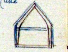
Cruck trusses in barn roof
Glibes Farm
House with a barn adjoining it at either end. Originally a rectangular House of one storey and attic of stone construction under a stone tile roof, with a detached barn both built probably c. 1600. It was later extended at the east end by the erection of a bakehouse, the east end of which was connected up to the east barn by a covered way, Later in the 17th century a one-storeyed extension was built at the west end of the house and the west barn was probably built at the same time. In the north wall is a doorway with an original stop-chamfered frame and the old frame of a five-light window which retains only one of its mullions. Inside the building all the partitions are of the local type with stop-chamfered framing and tall, narrow panels between the posts.
The east Barn has a timber-framed and weather-boarded north wall. The west Barn was extended towards the south and partly rebuilt early in the 18 th century.
Condition poor.
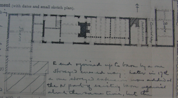
Ground floor plan of the Glibes
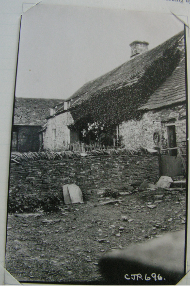
The Glibes
Blaenau
Two cottages described as house and cottage. The northernmost cottage or house, was built in the 16 th century on a T-shaped plan with the cross-wing at the north end. It is two storey and of stone construction under a stone tile roof. A porch was added on the east side of the south wing probably late in the 17 th or early in the 18 th century. Inside the building the oak partitions are of the local type. One of the ceiling-beams in the upper floor is supported on shaped and enriched brackets.
The southernmost cottage also 16 th century, comprising one story and attic and is now used as a shed and has been re-roofed with iron. It has an old chamfered oak door-frame and an original five-light window with diamond-shaped mullions. Inside the building has an original timber partition and ceiling beams comparable to the house.
Condition poor and bad
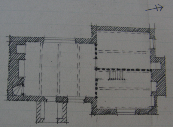
Ground floor plan of the Blainey
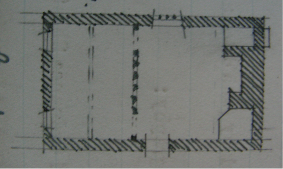
Ground floor plan of the cottage
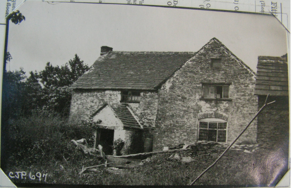
The Blainey
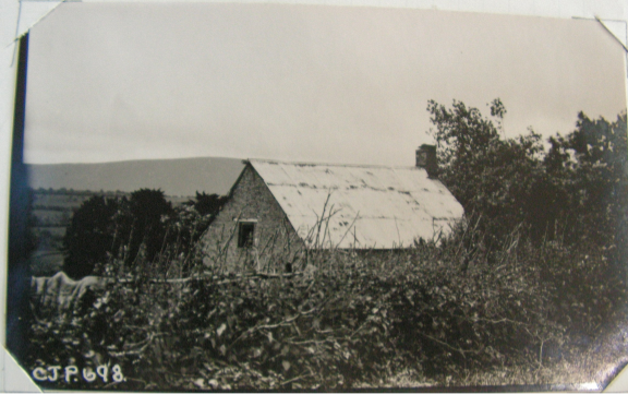
The cottage
Old Kates
Cottage and barn. The cottage is of early 17 th century date one storey plus attic of stone construction under a part stone tile and part corrugated iron roof. It is now used as a farm store and comprises two rooms divided by a stone wall which has two arched oak framed doorways flanking it. Above is an old truss the heavy tie beam cut through for a doorway [see sketch]. The truss beam has notches for former flat floor joists.
The east room has a wide fireplace next which is the original staircase of half-winding type with stone risers and old oak balk treads. The doorway to the staircase has a segmental arched head like that opposite in the dividing wall. This room has two transverse chamfered ceiling beams with broach stops and closely set exposed rafters. The west room has a similar ceiling beam.
The Barn south of the cottage, is divided into three bays by two pairs of crutch-trusses. These are of one piece from floor to apex and shaped to form obtuse angles instead of curves [see sketch]. The side walls are timber framed and weather boarded.
Condition poor.
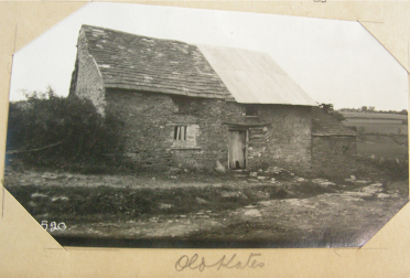
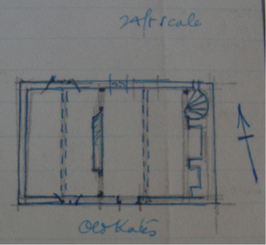
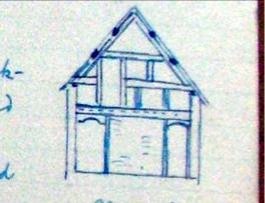
Central roof truss
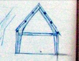
Barn cruck frame
Great Cefn Farm
House and barn. The House was built probably c. 1677, which date appears on the farm-buildings and is of stone under a stone tile roof. It has a lower addition at the north end. The entrance doorway has an old oak frame and some old oak mullioned windows remain. Two ground floor rooms are divided by a plastered timber framed partition and both have transverse ceiling beams with stop chamfers.
The Barn is in four bays with a stable and loft, of two bays, adjoining on the east. The walls of the barn are pierced with narrow loop-lights and the roof-trusses are of queen-post type. In the south wall of the stable are three old doorways with solid wood frames and rough stone labels. On the lintel of the middle doorway is inscribed the date 1677. The barn is probably a little earlier in date than the stables.
Condition fairly good
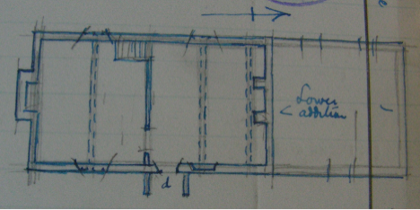
Ground floor plan of Great Cefn

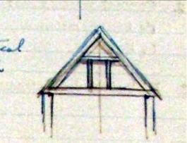
Barn roof
Lower Llanrosser
House is probably of 17 th century date comprising one storey and attic of stone construction under a stone tile roof. Empty at the inspection date and locked up. The entrance-doorway and some of the windows have old oak frames; the latter have chamfered mullions and one window retains its old leaded glazing. Inside the building is and old oak partition and the west wing has chamfered ceiling beams and exposed joists. Condition good but with much ivy.
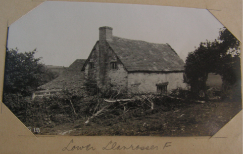
Ground floor plan of Lower Llanrosser
Tyn-y-gwynt
House now used as a cow-house and farm building, is of early 17 th century date of stone construction with part stone tile and part corrugated iron roof. The southern half is of two rooms the partition between them being of closely set timber studding of the 17 th century. The north room has a chamfered ceiling beam and exposed rafters and the middle room has old stop chamfered beams and a wide fireplace. The southern half has an old stop chamfered beam to ground floor and above it is a roof truss of heavy timbers but ordinary framing. Condition poor
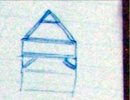
.
Southern dividing truss
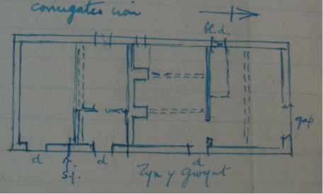
Ground floor plan of Tyn-y-Gwynt
Caeiron
House has the date 1681 carved on a stone in the east wall. Though this is probably the date of its erection, the house has been much altered in modern times. Construction is two storey with stone walling under a stone tile roof. The projecting stack on the south gable appears to be original. The lower rooms have heavy chamfered ceiling beams. Condition good.
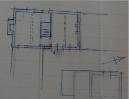
Ground floor plan of Caeiron
Oldhay Farm
House was built not later than the 15 th century, possibly as a timber-framed building, with four pairs of crutch trusses but the walls have since been rebuilt in stone under a stone tile roof. About 1600 it was remodelled, extended towards the north-east and a chimney-stack inserted; the porch on the south-east front and the lean-to addition at the back of the house are possibly also of this date. In the addition is one old two-light window with a chamfered oak frame and rough stone label. Inside, the building is divided into four bays by original crutch-trusses. The room facing the fireplace has exposed stop moulded beams and stop chamfered joists. The passage and north east room has exposed stop chamfered beams and exposed joists.
Condition practically derelict.
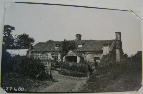
Old Hay Farm
Ground floor plan of Old Hay
Upper Pen-y-Park
House and Barn. The House has been partly rebuilt, and the remaining portion of the original house structure has been gutted to form a stable. It comprised one storey plus attic of stone construction under a stone tile roof probably of the same construction date as the adjoining barn.
The Barn is probably of late 15 th century date of stone construction under a stone tile roof. In the walls are small loop-lights. The south east gable has an owl hole with projecting flagstone perch. Along the south west side is a modern lean-to. Inside, the building is divided into five bays by crutch-trusses; the two end-bays are slightly narrower than the middle-bays.
Condition of house almost ruinous and barn poor.
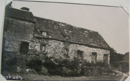
Upper Pen-y-Park house
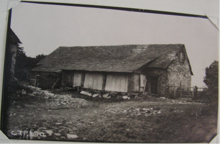
Upper Pen-y-Park barn
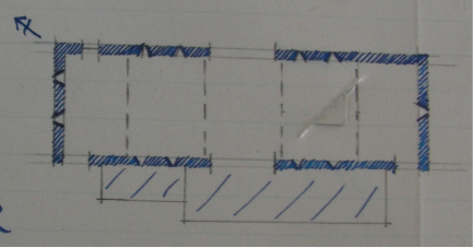
Ground floor plan of the house
Appendix 3
Listed properties in Upper Valley area
| Name | Date | Grade | Comment |
| Blaenau Cottage | C17-early C18th | 11 |
|
| Blaenau Farmhouse | C17th | 11 |
|
| Blaenau Barn | Late C17-mid C18th | 11 |
|
| Caeiron & cowshed |
| 11 | Farmhouse dated 1681 |
| Glibes Farmhouse | C17th | 11* |
|
| Glibes barn & cowhouse | C18th | 11* |
|
| Great Cefn Farmhouse | C17th | 11 |
|
| Great Cefn barn | C17th, | 11 | Lintol date 1677 |
| Lower Llanrosser | C17th | 11 | Now barn/cowshed |
| Old Hay Farmhouse | C15 – early C16 | 11 | 4 pairs crucks |
| Old Hay barn etc | C18 | 11 |
|
| Old Hay cow shelter | C18th | 11 |
|
| Oldhouse Farmhouse | Late C16 – late C17 | 11 |
|
| Oldhouse barn & cow house | Late C17-early C18th | 11 |
|
| Oldhouse shelter shed | Late C18th | 11 |
|
| Old Kates | C17th | 11 |
|
| Old Kates barn | C16-C17th | 11 | 4 pairs crucks |
| Pikes Farmhouse | Late C17-earlyC18th | 11 | Originally 5 pairs of crucks |
| Pikes barn | C18 | 11 |
|
| Pikes Barn no 2 | C18 | 11 |
|
| Ty’n-y-gwynt | Late C17th | 11 | Crucks |
| Tyn y gwynt barn | C17th | 11 |
|
| Upper Lower House Farmhouse | C17th | 11 |
|
| ULhouse barn | C16 or C17th | 11 | 3 pairs crucks |
| UL house cowhouse & granary | C17 | 11 |
|
| UL house stable | C18 | 11 |
|
| Upper Pen-y-park | Late C17-earlyC18th | 11 |
|
| UPP barn | Late C16-late 17th | 11 | Was 5 bay cruck |
Appendix 4
Summary of Farmhouse dates
For details of current listed properties see ELSG ref gc_ewy_3175
RC = Royal Commision 1931
L = Listed Buildings Records
D = Documents
Maerdy
RC: no entry; L: not listed
D: probable reference in 1624
Comment: most likely holding is much older with an original old house now lost
Caeiron
RC: house dated 1681
L: farmhouse dated 1681, two storey.
D: an ancient Manor, land mentioned in 1566; reference to house in 1656 with earlier C17th documents identifying ownership.
Comments: if the current house was built in 1681, there was almost certainly an older and possibly much older property on the land.
Upper Llanrosser
RC: no entry; L: not listed
D: first reference to a house is 1610
Comment: Remnant of old house across road amongst barns of probably late C16th.
Ty Uchaf
RC: no entry: L: not listed
D; first definitive mention of a house is 1669 although older documents back to 1604 refer to the property
Comment; currently a modern house with older shell adjoining. Earlier house, if there was one would have been at least C16th
Blainey
RC; house C16th 2 storey T shaped; cottage C16th one storey house with attic
L: farmhouse probably C17th T-plan, 2 storeys; cottage probably C17 or early C18th, two cell plan one storey & attic; barn probably late C17th to mid C18th.
D: first reference to a house is 1665 with a prior owner.
Comment: RC entries of C16th are more likely than L C17th.
Griglands
RC: no entry: L: not listed
D: a 1573 document relates to part of Griglands later described as two houses. Another house is also referred to in 1566 near Grigland
Comments: Farmhouse of two cell type with cow house attached now derelict probably C16th with further building [?house] above now demolished. Third house not known.
Old Hay
RC: house no later than C15th cruck framed
L: farmhouse perhaps C15th to early C16, cruck framed; barn & cow shelter probably C18th.
D: first reference to a house is 1566
Comment: cruck frame suggests at least C16th
Old House
RC: no entry
L: farmhouse probably late C16th-late C17th, two cell plan; barn and cow house probably late C17th or early C18th, shelter shed probably late C18th
D: first reference to a house is 1566
Comment: documents suggest C16th is most likely
Glibes
RC: c1600 one storey house with attic and one barn
L: farmhouse probably C17th, two cell plan; barn & cowhouse probably C18th.
D: first mention of the land was 1566 with a house mentioned in 1665
Comment: house at lease C17th and probably C16th.
New House
RC: no entry: L: not listed
D: first reference to a house is 1576 with the property referred to in 1566. By 1619 two houses are mentioned.
Comment: C16th farmhouse of small cottage type with adjoining stone barns
Upper Lower House
RC C17th, cruck framed barn
L: farmhouse probably C17th, two cell plan; barn perhaps C16th or C17th, cruck framed; cowhouse & granary probably C17th; stable probably C18th
D: first documentary reference is 1624
Comment: the cruck framed barn in particular, suggests the property is much older than the earliest known document. Barn at least late C16th
Lower Llanrosser
RC: house C17th one storey with attic.
L: farmhouse probably C17th, one storey with attic, local L-plan longhouse derivative
D: the earliest reference to the land is 1624
Comment: not a true hall/long house and probably C17th is correct
Pikes Farm
RC: not listed
L: farmhouse probably late C17th to early C18th, L-plan local development of longhouse type; two barns probably C18th
D: awaited
Comments; a true hall/long house with chimney insert to hall house dendro dated 1547
Upper Pen-y-Park
RC: house one storey with attic; barn late C15th cruck framed.
L: longhouse probably late C17th to early C18th; barn and shelter perhaps late C16th to late C17th, cruck framed
D: the earliest reference is to the barn in 1546
Comment: if true longhouse, then previously a hall house of possibly C16th; cruck framed barn suggests C15th quite possible
Little Cefn & Old Mill
RC: no entry: L: not listed
D: first reference to the land is 1566 with a house mentioned in 1665. Old Mill land referred to in 1624
Comment: house at least C17th and could be C16th
Great Cefn
RC: house and barn both 1677 [barn date]
L: farmhouse probably C17th, two cell plan, two storeys; barn dated 1677
D: possibly held with Old Kates [see below]
Comment: house design suggests C17th quite possible
Sunnybank
RC: no entry: L: not listed
D: earliest reference to land 1604 with uncertain entry in 1665 referring to a house
Comment: probably no earlier than C17th
Lower Pen-y-Park
RC: no entry: L: not listed
D: first reference to the land is 1590 with a house mentioned in 1624
Comment: documents suggest house at least early C17th.
Old Walls
RC: no entry: L: not listed
D: earliest reference to a house is 1585
Comment: a cottage on the edge of Vagar Hill common possibly C16th.
Castle
RC: no entry: L: not listed
D: earliest reference is 1751
Comment; documents suggest C18th.
Tyn –y-Gwynt
RC: house early C17th cruck framed
L: probably late C17th, extended two cell to form longhouse; barn probably C17th.
D: earliest reference to a house is 1624 which also refers to earlier ownership
Comments: dendrochronology places the cruck frame construction in the early 1500s
Also note Transactions 1998 p285
Old Kates
RC: cottage early C17th one storey with attic; barn cruck framed.
L: farmhouse C17th, two cell plan; barn perhaps C16th or C17th, cruck framed
D: earliest reference is 1566 when land and one messuage included Great Cefn land
Comment: documents and cruck barn construction suggest at least C16th and house may be same or somewhat later.
Birches
RC: no entry: L: not listed
D: earliest reference 1793
Comment: an edge of commons cottage with alterations, probably C18th earliest
Spring Castle
RC: no entry: L: not listed
D: earliest reference 1753
Comments: documents suggest C18th
Byld Bryth
RC: no entry: L: not listed
D: earliest occupier date 1711
Comments: documents suggest early C18th
Pucca
RC: no entry: L: not listed
D: earliest reference to a house 1687 with earlier documents from 1590
Comment: 1687 reference refers to a “poor house”. A 1740 entry states any house had long since fallen down
Caetompkin
D: possible 1750 entry
Randiroth
D: possible 1574 entry
Other property including Golden Post, Tanners, Gwerngenny, Lane Head and Glis have no relevant RC, L or D entries
more discussion on each specific house
add more general comments on design/floor plan
Appendix 5
| Appendix 5.1 |
| Summary of Owners & Occupiers by date: C16th & C17th |
|
|
| C16th | 1600-1623 | 1624 | 1625-1650 | 1651-1675 | 1676-1700 | |
| Abergavenny Manor |
|
|
|
|
|
| ||
|
|
|
|
|
|
|
|
| |
| The Maerdy | freeholder |
|
|
|
|
|
| |
|
| occupier |
|
|
|
|
|
| |
| Upper Llanrosser 1 | freeholder |
| Hopton |
|
|
|
| |
|
| head lessee |
| Simon Clarke |
|
| William James |
| |
|
| occupier |
| Thomas Clarke |
|
| John Booth |
| |
| Upper Llanrosser 2 | freeholder |
| Hopton |
|
|
|
| |
|
| head lessee |
| Harry David |
|
| William James |
| |
|
| occupier |
|
|
|
| Katheren Powell |
| |
| Ty Ucha | freeholder | Thomas James > Thomas Wm Powell |
| Hopton |
|
|
| |
|
| head lessee | Jenkin Madye | Thomas Powell Maddy |
|
|
| William James | |
|
| occupier | Harry Thomas ap Richard |
|
|
| James Prosser | Philip Steicus | |
| Griglands: Ievan Greges | freeholder |
|
| Hopton |
|
|
| |
|
| head lessee | Symond Aparrie/ John Parry |
|
| Blanch Parry | Margaret Parry/ Valentine Parry/ Elizabeth Wotton |
| |
|
| lessee |
|
|
|
| William Bridges |
| |
|
| sub-lessee |
|
|
|
| Richard Corbett |
| |
|
| occupier |
|
|
|
| Thomas & James Quarrell/ Thomas Price |
| |
| Griglands: Tire Griege | freeholder | Richard Howell ap Rees/ David Thomas |
| Leison Thomas |
|
|
| |
|
| occupier |
|
|
|
|
|
| |
| Old Hay: Kitchen lands | copyholder |
|
| Thomas William Prise |
|
| John Price/ Thomas Smith | |
|
| occupier |
|
|
|
|
|
| |
| Old Hay: pt Pucca | copyholder |
|
|
|
|
|
| |
|
| occupier |
|
|
|
|
|
| |
| Tyre Cockham | copyholder 1 |
| John Harry Powell | John Powell |
|
| Sir John Morgan/ Thomas Morgan | |
|
| occupier |
|
|
|
|
|
| |
| Glibes | copyholder |
| William Harry David Prosser |
|
|
| William Harry | |
|
| occupier |
| John Philip/ Baugh |
|
|
|
| |
| Upper Lower House | freeholder |
|
| David Howell ap Robert |
|
|
| |
|
| occupier |
|
|
|
|
|
| |
| Lower Llanrosser | freeholder | Phillipp Jenkyns | John David & Thomas Hughes | John Thomas Hughe |
|
|
| |
|
| occupier |
|
|
|
|
|
| |
| Pikes Farm | freeholder |
|
|
|
|
|
| |
|
| head lessee |
|
|
|
|
|
| |
|
| occupier |
|
|
|
|
|
| |
| Old Mill | freeholder |
|
|
|
|
|
| |
|
| copyholder |
|
|
|
|
|
| |
|
| occupier |
|
|
|
|
|
| |
|
|
|
|
|
|
|
|
| |
|
|
|
|
|
|
|
|
| |
| Hopton Manor |
|
|
|
|
|
| ||
| Caeiron | freeholder | Thomas Whitney | Walter Lloyd |
| Lewis > Thomas > John > Thomas Powell |
| ||
|
| occupier |
|
|
|
|
|
| |
| Blainey house & land | freeholder |
| Walter Poskins | William Prichard David |
| John William Prichard |
| |
|
| occupier |
|
|
|
|
|
| |
| Blainey land | freeholder |
| James Harry Powell | John Powell | Morgan Powell | Sir Thomas Morgan |
| |
|
| occupier |
|
|
|
|
|
| |
| Tyre Cockham see Old House |
|
|
|
|
|
| ||
| Griglands | freeholder | William Cecil |
|
| William Prees William | Thomas Smyth |
| |
|
| occupier |
|
|
|
|
|
| |
| Old Hay | freeholder | Roger Vaughan |
| Richard Thomas Powell |
| Thomas Powell/ Ann Church |
| |
|
| occupier |
|
|
|
|
|
| |
| Old House | freeholder | Henry Howell Gwillim Bean [ab Euan] |
|
|
| Morgan Powell |
| |
|
| occupier |
|
|
|
|
|
| |
| Old House land | copyholder |
|
|
|
|
|
| |
| Glibes house | freeholder | Howell ap Richard Morgan |
|
| Howell Prichard | William Harry | Watkin William Harry | |
|
| occupier |
|
|
|
|
|
| |
| New House | freeholder | David ap Rees Mady | pt Gwenllyan Watkins/John Smyth |
|
| David & Thomas Smyth |
| |
|
| occupier | William Price | pt John Williams/John Smyth |
|
|
|
| |
| Upper Pen-y-Park | freeholder | Howell Gwillym ap Rees |
| Jane Prichard & John Powell |
| John Smith & William Delahay/ Ann Church | Thomas Church | |
|
| occupier |
|
|
|
|
|
| |
| Little Cefn | freeholder | Rice Griffith | four daughters of Rice Griffith |
|
| David Smyth and Hugh Charles |
| |
|
| occupier |
|
|
|
|
|
| |
| Great Cefn | freeholder | Thomas Gilbert |
|
| Lewis Gilbert | Thomas David |
| |
|
| occupier | Morgan Williams |
|
|
|
|
| |
| Old Kates | freeholder | Thomas Gilbert |
|
| Lewis Gilbert | Thomas David |
| |
|
| occupier | Morgan Williams |
|
|
|
|
| |
| Appendix 5.2 |
| Summary of Owners & Occupiers by date: C18th |
|
|
| 1701 | 1702 | 1703-1725 | 1726-1750 | 1751-1775 | 1776-1800 |
| Abergavenny Manor |
|
|
|
|
|
| |
|
|
|
|
|
|
|
|
|
| The Maerdy | freeholder | Delahay |
|
|
|
|
|
|
| occupier |
|
|
|
|
| J Yeomans/ Timothy Howard |
| Upper Llanrosser 1 | freeholder |
|
|
|
|
| Henry Allen |
|
| head lessee |
| Edward Perkins |
| James Parry |
| James > John Parry |
|
| occupier |
|
|
|
|
| John Winson/ James Jones |
| Upper Llanrosser 2 | freeholder |
|
|
|
|
| Henry Allen |
|
| head lessee | Thomas Delahay |
|
|
| John Delahay |
|
|
| occupier |
|
|
|
|
|
|
| Ty Ucha | freeholder |
|
|
|
|
| William Parry |
|
| head lessee |
| John Carpenter |
| Timothy Price | John Jones |
|
|
| occupier |
| Thomas Prosser | Thomas Probert |
|
| Thomas Philips |
| Griglands: Ievan Greges | freeholder | John Price |
| John Price |
|
| Bridgwater/ Lewis/ John Lewis |
|
| head lessee |
|
|
|
|
|
|
|
| lessee |
|
|
|
|
|
|
|
| sub-lessee |
|
|
|
|
|
|
|
| occupier |
|
| James Phillip Smith |
|
| Nicholas Taylor/ Joshua Maddy/ Samuel Jones |
| Griglands: Tire Griege | freeholder |
|
| H [?Humphrey] Thomas or William Watkins |
|
|
|
|
| occupier |
|
|
|
|
|
|
| Old Hay: Kitchen lands | copyholder | Thomas Smith |
| Thomas Smyth/ | Daniel Smyth |
| Thomas Smith/ John Jones |
|
| occupier |
|
|
|
|
| David Jenkins/ Eliz Jenkins/ John Williams/ Wm Williams/ Samuel Lewis |
| Old Hay: pt Pucca | copyholder |
|
|
|
|
|
|
|
| occupier |
|
|
|
|
|
|
| Tyre Cockham | copyholder 1 |
|
| Sir Thomas Morgan/ Thomas Harris |
|
|
|
|
| occupier |
|
| Richard Shaw |
|
|
|
| Glibes | copyholder |
|
| Walter Harris |
|
|
|
|
| occupier |
|
|
|
|
|
|
| Upper Lower House | freeholder |
|
| James Probert/ Richard Shaw |
|
| Mr Parry/ George Morgan |
|
| occupier |
|
|
|
|
| Mr James/ Mr Davice/ Benjamin Meredith/ Mr Gittoes |
| Lower Llanrosser | freeholder | Walter Delahay |
|
|
|
|
|
|
| occupier |
|
|
|
|
| Thomas Edwards/ Thomas Grenow/ William Davis |
| Pikes Farm | freeholder |
|
|
|
|
|
|
|
| head lessee |
|
|
|
|
|
|
|
| occupier |
|
|
|
|
|
|
| Old Mill | freeholder |
|
|
|
|
|
|
|
| copyholder |
|
|
|
|
|
|
|
| occupier |
|
|
|
|
|
|
|
|
|
|
|
|
|
|
|
|
|
|
|
|
|
|
|
|
| Hopton Manor |
|
|
|
|
|
| |
| Caeiron | freeholder |
| John Powell |
|
|
| Mr Price |
|
| occupier |
|
|
|
|
| Samuel Maddy |
| Blainey house & land | freeholder |
| John Watkins |
|
|
| Mrs Green/ James Jones/ Thomas Harris |
|
| occupier |
|
|
|
|
|
|
| Blainey land | freeholder |
| Sir Thomas Morgan |
|
|
|
|
|
| occupier |
|
|
|
|
|
|
| Tyre Cockham see Old House |
|
|
|
|
|
| |
| Griglands | freeholder |
| Thomas Smyth |
|
|
| Gloons/Green |
|
| occupier |
|
|
|
|
| James Parry/ William Davis |
| Old Hay | freeholder |
| Thomas Church |
| Thomas Smith |
|
|
|
| occupier |
|
|
|
|
| Thomas Davies/ Samuel Lewis |
| Old House | freeholder |
| Sir Thomas Morgan |
|
|
| Mrs Green/ James Jones |
|
| occupier |
|
|
|
|
| Samuel Jones |
| Old House land | copyholder |
| Sir Thomas Morgan |
|
|
|
|
| Glibes house | freeholder |
| William Harry |
|
|
| Walter Harris |
|
| occupier |
|
|
|
|
|
|
| New House | freeholder |
| Thomas Smith |
| David Smith/ Job Gilbert |
| Thomas Gilbert/ widow Gilbert/ John Gilbert |
|
| occupier |
|
|
|
|
| Thomas Hains/ John Smith/ William Davis |
| Upper Pen-y-Park | freeholder |
| Thomas Church |
| Mr Thomas/ Thomas Williams |
| Philip Harris/ James Dolward |
|
| occupier |
|
|
|
|
| David Jenkins/ Elizabeth Jenkins |
| Little Cefn | freeholder |
| Thomas Smith & Charles Charles | David Smith |
|
| David Prichard |
|
| occupier |
|
|
|
|
| James Harris/ Thomas Williams/ John Pugh |
| Great Cefn | freeholder |
| Thomas Smith |
|
|
| Rev'd Hopton |
|
| occupier |
|
|
|
|
| John Smith |
| Old Kates | freeholder |
| Thomas Smith |
|
|
| Mr Francis |
|
| occupier |
|
|
|
|
| Samuel Jones; Wm Williams; Richard Havard |
| Appendix 5.3 |
| Summary of Owners & Occupiers by date: C19th |
|
|
| 1801-1825 | 1826-1843 | 1844 Tithe Map |
| Abergavenny Manor |
|
|
| |
|
|
|
|
|
|
| The Maerdy | freeholder |
|
| Thomas Delahay |
|
| occupier | Robert Howard | Thomas James/Jones | George Probert |
| Upper Llanrosser 1 | freeholder |
|
| Henry Allen |
|
| head lessee |
|
|
|
|
| occupier | William Williams |
| Joseph Mainwaring |
| Upper Llanrosser 2 | freeholder |
|
|
|
|
| head lessee |
|
|
|
|
| occupier |
|
|
|
| Ty Ucha | freeholder | James Spencer | Thomas Philips | Thomas Philips |
|
| head lessee |
|
|
|
|
| occupier | Richard Jones |
| Thomas Philips |
| Griglands: Ievan Greges | freeholder | Lytham Lewis/ Richard Sandiland | Richard Sandiland | Th & Geo Attwood & Richard Spooner |
|
| head lessee |
|
|
|
|
| lessee |
|
|
|
|
| sub-lessee |
|
|
|
|
| occupier | Samuel Jones/ William Jones/ Thomas Price | Thomas Price | Thomas Price |
| Griglands: Tire Griege | freeholder |
|
|
|
|
| occupier |
|
|
|
| Old Hay: Kitchen lands | copyholder | John Jones | John Jones/ Richard Hampton/ Thomas Delahay | Thomas Delahay |
|
| occupier | Samuel Lewis/ John Roberts/ Robert Howard | Robert Howard | William Howells |
| Old Hay: pt Pucca | copyholder |
|
|
|
|
| occupier |
|
|
|
| Tyre Cockham | copyholder 1 |
|
|
|
|
| occupier |
|
|
|
| Glibes | copyholder | Walter Harries |
|
|
|
| occupier |
|
|
|
| Upper Lower House | freeholder | George Morgan | George Lewis | George Lewis |
|
| occupier | James Lilwall | William Andrews | George Lewis |
| Lower Llanrosser | freeholder |
|
| Thomas Delahay |
|
| occupier | Samuel Jones | Mary Gane | Francis Stephens |
| Pikes Farm | freeholder |
|
|
|
|
| head lessee |
|
|
|
|
| occupier |
|
|
|
| Old Mill | freeholder |
|
|
|
|
| copyholder |
|
|
|
|
| occupier |
|
|
|
|
|
|
|
|
|
|
|
|
|
|
|
| Hopton Manor |
|
|
| |
| Caeiron | freeholder | Mr Maddy | William Maddy | Mrs Maddy |
|
| occupier | Samuel Maddy | Thomas Pugh | William Prosser |
| Blainey house & land | freeholder |
|
| Thomas Harris |
|
| occupier |
|
| Thomas Harris |
| Blainey land | freeholder | Sir Charles Morgan/ Thomas Harris |
|
|
|
| occupier |
|
|
|
| Tyre Cockham see Old House |
|
|
| |
| Griglands | freeholder | JM Green | R Sanderland | Th & Geo Attwood & Richard Spooner |
|
| occupier | Thomas Seaborn/ | Thomas Price | Thomas Price |
| Old Hay | freeholder | Thomas Smith/John Jones | John Jones/ Richard Hampton /Thomas Delahay | Thomas Delahay |
|
| occupier | Samuel Lewis/John Roberts/Robert Howard | Robert Howard | William Howells |
| Old House | freeholder | Thomas Lanwarn |
| late Thomas Lanwaine |
|
| occupier | Timothy Howard |
| Howard Howard |
| Old House land | copyholder |
|
|
|
| Glibes house | freeholder |
| Stephen Hayward | Stephen Heyward |
|
| occupier |
| Walter Harris | Thomas Harris jnr |
| New House | freeholder | John Gilbert/William Williams | William Williams/ Richard Yeomans | Sarah Yeomans |
|
| occupier | John Williams | James Price | James Price |
| Upper Pen-y-Park | freeholder | Mrs Maddy | Thomas Ware | Thomas Ware |
|
| occupier | Thomas Jenkins | Thomas Jenkins/ Thomas Bevan | Sylvanus Watkins |
| Little Cefn | freeholder | David Prichard/ Samuel Taylor | Samuel Taylor/ Jas Bevan | Francis Lewis Bodenham |
|
| occupier | James Prichard/ Timothy Howard/ James Price |
| Thomas Phillips |
| Great Cefn | freeholder | Mr Bough | Mr Webster; Rev'd Morgan | Rev'd Morgan |
|
| occupier | Jas Phillips; Walter Maddy | Walter Maddy | Walter Maddy |
| Old Kates | freeholder | Mrs Francis | Mrs Francis | James Baker |
|
| occupier | John Williams; William Symonds | John Pary; Thomas Wood | Thomas Wood |
Appendix 6
List of Upper Valley Properties by Acreage
| Name | Tithe acreage |
|
| acres.roods.rods |
| Maerdy | 144.1.18 |
| Caeiron | 115.0.7 |
| Upper Llanrosser | 104.3.25 |
| Ty Uchaf | 96.3.22 |
| Blainey | 83.1.27 |
| Grigland | 79.3.9 |
| Old Hay | 78.0.18 |
| Old House | 77.0.37 |
| Glibes | 69.2.2 |
| New House | 61.2.3 |
| Upper Lower House | 61.1.22 |
| Lower Llanrosser | 60.2.18 |
| Pikes | 57.3.31 |
| Upper Pen y Park | 53.3.38 |
| Little Cefn & Old Mill | 46.3.10 |
| Great Cefn | 39.3.17 |
| Sunnybank | 38.2.27 |
| Lower Pen y Park | 35.1.5 |
| Old Walls & Castle | 35.0.24 |
| Tyn y Gwynt | 34.2.35 |
| Old Kates | 33.2.30 |
| Land from Craswall | 30.3.39 |
| Birches | 22.0.37 |
| Byld Bryth & Spring Castle | 19.2.4 |
| Pucca | 19.1.13 |
| Golden Post | 13.3.24 |
| Tanners | 9.0.31 |
| Gwerngenny | 7.3.4 |
| Lane Head | 7.2.31 |
| Glis | 7.0.15 |
| Caetompkin | 4.3.35 |
| Land above UPP | 3.2.18 |
| Land by Cefn | 2.1.8 |
| House & garden | 1.3.38 |
| Ivy House | 1.3.27 |
| Cottage & garden | 1.1.35 |
| Meadow below Ivy House | 1.0.24 |
| Land by Cefn | 0.3.24 |
Appendix 7
Wills and Probate Documents relating to property owners and occupiers in the Upper Escley Valley
| Name | Property | Date | Parish |
| John Powell | Caeiron/Blainey | 1663 | ME |
| Samuel Maddy | ditto | 1821 | ME |
| William James | Ty Ucha & others | 1702 | St M |
| Timothy Price | Ty Ucha | 1746 | ME |
| William Parry | ditto | 1790 | ME |
| Thomas Smyth | New House | 1711 | ME |
| David Smith | New House | 1739 | ME |
| Abraham Pugh | Merdy | 1727 | ME |
| Timothy Howard | Maerdy | 1847 | ME |
| Thomas Jones | ditto | 1837 | ME |
| Edward Perkins | Upper Llanrosser | 1735 | ME |
| James Parry | ditto | 1790 | Not NLW |
| Thomas Harries | Blainey | 1846 | ME |
| Thomas Jones | Cae Pants | 1758 | ME |
| Thomas Miles | Cae Pants | 1724 | ME |
| Henry Morgan | Castle | 1798 | Newton |
| William Harries | Glibes | 1710 | ME |
| Thomas David | Great Cefn | 1710 | ME |
| Thomas Williams | ditto | 1831 & 1834 | ME |
| David Prichard | Little Cefn | 1779 | ME |
| Mary Roberts | ditto | 1782 | ME |
Notes:
1. Original documents are held at the National Library of Wales, Aberystwyth
2. Photographs of the documents can be viewed on the Ewyas Lacy Study Group website at http://www.ewyaslacy.org.uk/d o c.php?d=rs_mic_0285
References
[1] The Ewyas Lacy Study Group was originally formed in 2006 by a group of local residents to collate documents and research relating to the area in southwest Herefordshire where they live. The aim was to provide the widest possible on-line access to historical records relating to Ewyas Lacy as a foundation for a comprehensive local history. The Group’s website, “A History of Ewyas Lacy” can be found at http://www.ewyaslacy.org.uk
[2] In 1908 a Royal Commission on Historical Monuments was established to ‘make an inventory of the Ancient and Historical Monuments and Constructions connected with or illustrative of the contemporary culture, civilization and conditions of life of the people in England , excluding Monmouthshire, from the earliest times to 1700.’ Volume I of the Herefordshire inventory, covering the South-West of the County including the hundred of Ewyas Lacy, was completed in 1930 and published in 1931. A full transcript of their descriptions of properties in Ewyas Lacy and the relevant plates and pictures can be found online at http://www.ewyaslacy.org.uk/doc.php?d=rs_ewy_0203
[3] “A Brief History of Ewyas Lacy” by Nina Wedell, with references and bibliography, is available online at http://www.ewyaslacy.org.uk/doc.php?d = nw_ewy_9001
[4] “The Lordship of Ewyas Lacy from Norman Times to the Present Day” by Bob Steele and Nina Wedell is available on line at http://www.ewyaslacy.org.uk/doc.php?d=rs_ewy_0200
[5] 1624 Abergavenny survey document held at Gwent Archives; [previously Gwent Record Office] MAN/A/151 0022
[6] “Leases and Coppy holders in the Manor of Ewyas Lacye Herefordshire” 1701 Abergavenny survey; transcription by Ewyas Lacy Study Group available on line at http://www.ewyaslacy.org.uk/doc.php?d=nw_ewy_1101
[7] ‘A Survey of All Tenures’ carried out on behalf of Robert Dudley Earl of Leicester 1566; Muniments Room, Longleat DU/Vol.XV11
[8] A survey dated 6th September 1653 detailing the sale of the Manors of Ewyas Lacy, Walterstone and Trewaylan under Acts of Parliament to Major General Thomas Harrison after their expropriation by Parliament during the English civil war. A certified manuscript copy dated 1836 and marked ‘office copy’ has been transcribed and is available on line at http://www.ewyaslacy.org.uk/doc.php?d=rs_ewy_0061
[9] “Manor of Ewyas Lacy on the part of John Jeffreys”; transcription of this survey by Ewyas Lacy Study Group is available on line at http://www.ewyaslacy.org.uk/doc.php?d=nw_ewy_2103
[10] Owners and Occupiers of land in Ewyas Lacy; Tithe maps and schedules are available on line from the Ewyas Lacy Study Group at http://www.ewyaslacy.org.uk/doc.php?d=nwgc_ewy_3000
[11] Ewyas Lacy Study Group website: ‘The History of Ewyas Lacy” contains archive references and summaries, of documents from a wide range of sources. Transcriptions and/or photographs of many of them are also available on line at http://www.ewya s lacy.org.uk where a site search engine can be used to locate specific references.
[12] Pikes Farm – The History of a Farm in Michaelchurch Escley, Herefordshire, by Tony Gray. Online at http://www.ewyaslacy.org.uk/doc.php?d=tg_mic_0140
Ref: tg_mic_0141