
Title: | Archaeological Observations in the Walterstone Area: An Historic Landscape Walk Report |
Date: | 2000 |
Guest Contribution: Introduction
This report on the archaeology of the Walterstone area has been written by Keith Ray and Tim Hoverd of Herefordshire Archaeology, Herefordshire Council’s county archaeological service, and is reproduced here in full with the authors’ kind permission.
Ewyas Lacy Study Group
 |
Herefordshire Archaeology
Conservation and Environmental Planning
Planning Services
Environment Directorate
Herefordshire Council
Archaeological Observations in the Walterstone area : An Historic Landscape Walk Report
Herefordshire Archaeology Report No 10.
Report prepared by
Keith Ray and Tim Hoverd
Contents
Summary
Introduction
Method
Results
Discussion
Acknowledgements
Archive
Herefordshire Archaeology is Herefordshire Council’s county archaeology service. It advises upon the conservation of archaeological and historic landscapes, maintains the county Sites and Monument Record, and carries out conservation and investigative field projects. The County Archaeologist is Dr. Keith Ray.
Summary:
A first Historic Landscape Walk was organised in April 1999 in the Walterstone area of south Herefordshire. The practice was established, that, preparation for the walk included a check of existing Sites and Monuments Record data, and a preliminary reconnaissance visit.
This report provides a brief account of previously unrecorded sites observed in the field, together with re-appraisals of some known sites. Unless otherwise stated, the sites described in the report are observable from public rights of way. At Walterstone in April 1999, the walk began and ended at the common. The route followed descended into the valley of the Grafel brook and down to Walterstone church, returning to the common via the northern side of Walterstone Camp. New sites located during the walk included features on the common itself, features within fields west of Coed-y-Grafel, a mill at Rockyfold and features associated with Walterstone camp, an Iron Age hill fort.
Disclaimer: It should not be assumed that land referred to in this document is accessible to the public. Location plans are indicative only. NGR’s are accurate to approximately 10m. Measured dimensions are accurate to within 1m at a scale of 1:500, 0.1m at 1:50, and 0.02m at 1:20.
Contact details: Herefordshire Archaeology, PO Box 144, Hereford. HR1 2YH
Copyright Herefordshire Archaeology 2004.
Archaeological Observations in the Walterstone area : An Historic Landscape Walk Report
Herefordshire Archaeology Report No 10.
Herefordshire Archaeology, October 2000. (revised 2004)
Introduction
The Historic Landscape Walk at Walterstone in April 1999 was the first in what has become a continuing monthly series of public guided walks in which both the archaeology and the historic landscape of a selected localised area of the county is explored and explained. Prior to the walk only three sites were recorded on the Sites and Monuments Record.
Figure 1: Walk Location Map
The walk was planned to start from a convenient starting point at the south end of Walterstone Common, the aim then was deliberately to cross the Grafel valley to the southern slopes of Mynydd Merddin. The planned route then descended the southward ridge to Walterstone, to cross the Grafel again and then returned to the common passing the northern side of Walterstone Camp.
Method
The reconnaissance method simply involved a pre-walk visit. Features noted on this visit and on the subsequent walk were again checked against existing records and were subject, where appropriate and possible, to further checks against aerial photographs and available historic maps.
Results
These are discussed below as a numbered series of observations, ordered according to the sequence in which they were encountered along the route of the walk.
1. Earthwork features on the open areas of Walterstone Common.
Walterstone Common as surviving today is but a fragment of what once must have been an extensive area of common land. The pattern of small enclosures around, but particularly to the west of the existing “green”, indicates the likely former extent of the common. The enclosures presumably represent piecemeal encroachments and fencing of the common.
Within the remains of the common is an area containing small, levelled areas and low banks. These appear to be the earthwork remains of a squatter settlement and comprise a series of roughly rectangular platforms, approximately 2.5m wide and 4.5m long. These are associated with low banks presumably dividing up and enclosing plots for yards or gardens.
2. Earthwork features within the enclosed area of Walterstone Common.
Field Kiln NGR SO: 3519 2575 (HSM 30388)
Although common until recent times, this class of monument is now rare in pasture and arable environments. This is largely due to the nature of the earthwork remains and the increase in intensive agricultural practices. A field kiln is typically 2 – 3m in diameter and comprises a level area cut into the natural slope with the spoil arranged on its down – slope side in a semi-circle. This is to ensure an even firing. There is often a small rise in the centre of the levelled area indicating the centre of the bonfire. Field kilns were used to locally produce bricks and tiles, by stacking the material to be fired and constructing a bonfire around it and within it. This was then lit and more fuel supplied as necessary until the material had been satisfactorily reduced.
Holloway, NGR SO:3516 2568 to SO:3500 2575 (HSM 30389)
Running west from the common towards Lower Coed-y-grafel there is a holloway. This has been cut into the hill-slope through use and indicates that it was well established routeway which must have been used for a considerable period of time.
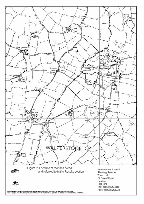
3. Coed-y-grafel, NGR SO:3479 2582 (HSM 1454)
This location is noted as an example of how easily natural features can, given time and the repetition of folklore, become recorded as important archaeological sites. In 1782 it was reported that fragments of a Roman pavement (tesserae) had been recovered from this location. Thus leading to the belief that there was a high status Roman Villa nearby. In 1954 the Ordnance Survey visited the site with a local resident who took them to a “pavement” at the ford. The “pavement” was in fact the natural bedrock which, due to the angle of dip, fractures into small roughly square blocks resembling tesserae. It is likely that this in conjuction with the term “pavement” and vague, second hand descriptions, has led to the belief that a Roman mosaic and therefore a villa existing here.
This may be supported by place name evidence in that Coed means wood in Welsh and Grafel means coarse sand or gravel. This area may have changed little since being given this name as there is still a wood in the valley bottom.
4. Field systems NGR SO:3470 2590 (HSM 30390)
On the western bank of the brook, as we head uphill towards Great Hunthouse Farm, through a long but relatively narrow field, there is a series of low banks or lynchets running across the field. Between these lynchets is the remnants of ridge and furrow created by ploughing in the medieval and post-medieval periods.
5. Walterstone Motte & Bailey NGR SO:3395 2500 (HSM 5590)
This is situated approximately 75m west of the church and comprises a circular motte, 40m in diameter and 8m high with a kidney shaped bailey on its eastern and south – eastern sides. The motte is surrounded by a ditch or moat, which is partly wet. The edge of the bailey is delineated by a natural scarp to the east and by a low rampart to the south.
6. Walterstone Church NGR SO: 3405 2495 (HSM 6762)
The parish church of St. Mary comprises a chancel, nave and south porch and is constructed of local sandstone rubble. The construction date for the church is unclear and it may have been extensively re-built in the 14th century, as is suggested by the presence of a reset 13th century capital within the south porch. Later additions include a 15th century chancel window and 16th century south porch and windows.
There is the base of a 14th century preaching cross to the south of the church.
7. Rockyfold Mill NGR SO: 3425 2491 (HSM 30391)
On the eastern side of the brook stands Rockyfold, a stone built house of 17th or 18th century origins. This was originally a mill and the race is clearly visible running on a north / south alignment immediately to the west of the house.
8. Fort annexe NGR SO: 3500 2525 (HSM 1586, HSM 1466))
Immediately to the north of the Iron Age hill-fort of Walterstone Camp and apparently bordering a holloway, (HSM 3919), is a number of platforms, banks and ditches. These cover an area of approximately 0.5 acre. Documentary evidence strongly suggests that at least some of these earthworks may be associated with a medieval or earlier chapel dedicated to the Celtic Saint, St. Ailworth. The form of the earthworks is complicated by the later construction and subsequent demolition of a house and garden.
The earthworks appear to be enclosed within an roughly triangular area of approximately 2 acres in size, bounded to its north west by the holloway, to its north and north-east by the present road and a break in slope and to its south by the outer rampart of Walterstone Camp. It is suggested that this triangular area is an annexe to the hill-fort which was later used as an enclosure for the chapel site. As an annexe it would effectively have doubled the area of the fort and would have afforded an extra line of defence on the side that is most problematical to defend as the fort is approached on level ground from the north and east.
Discussion
The route runs through a largely medieval landscape with open fields and ridge and furrow covering much of the valley base and sides. This is in contrast to the Monnow Valley and Cloddock where a more ancient field pattern survives.
The field kiln site on the edge of Waltersone Common is very significant in terms of its survival. Until the middle of the 20th century such sites were common. However with the loss or improvement of much permanent pasture and the loss of established orchards many of these sites have been destroyed. It is only now in marginal areas such as Walterstone, (and a similar site at Walkmill Farm, Ewyas Harold), that these subtle types of earthworks survive.
The relationship between the apparent site of the chapel to St. Ailworth, within the fort annexe, and the parish church of St. Mary is unknown. The choice of location for the chapel is unusual lying within the hill-fort annexe and at a point where it almost impinges upon the main defensive circuit itself. One explanation for this may be presence of the holloway being an important and well established routeway leading from the valley bottom to the hill top and from there along the ridge.
The position of the church in relation to the castle can be compared directly to those at Rowlestone and Llancillo, and even to larger settlement sites as at Kilpeck. This close association between the two monuments illustrates well the degree of planning that went into choosing sites for both structures. This association is very different to places such as Cloddock and Lanveynoe, where it appears that the church is given the principal site and there was no attempt to compliment this with a castle. This difference is presumably linked to the methods employed to control the flow of people, livestock and goods using the important routeway along the Monnow Valley.
Acknowledgements
I would like to thank Dr. Keith Ray, County Archaeologist for his editorial comments in the preparation of this report.
Archive
4 HSM cards
Further Publication
A note on the work reported here will be published in the CBA publication West Midlands Archaeology, 43, for 2000.
References
RCHME (1935) An Inventory of the Historical Monuments in Herefordshire, Vol. II-South-West . Royal Commission on Historical Monuments, England. London: HMSO.
Ordnance Survey (1998) Brecon Beacons Nation Park , (eastern area), Outdoor Leisure 13, Scale 1:25 000 . Southampton: Ordnance Survey.
Validation
Herefordshire Archaeology operates a validation system for its reports, to provide quality assurance and to comply with Best Value procedures.
This report has been checked for accuracy and clarity of statements of procedure and results.
Dr. K. Ray County Archaeologist.
Ref: rs_wal_0095