
Title: | Olchon Court, Llanveynoe: An Investigation of the Site of Olchon Court Buildings |
Date: | 2010 |
Guest Contribution: Introduction
This report, outlining the archaeology of Olchon Court buildings, has been written by Tim Hoverd and Lara Bishop and is reproduced here in full with the authors’ kind permission and the approval of Herefordshire Archaeology, Herefordshire Council’s County Archaeological Service.
Ewyas Lacy Study Group
| Olchon Court, Llanveynoe: AN INVESTIGATION OF THE SITE OF OLCHON COURT BUILDINGS Report prepared by Tim Hoverd & Lara Bishop
March 2010 |
Herefordshire Archaeology Report No. 280
Herefordshire Archaeology
Conservation and Environmental Planning
Planning Services
Regeneration Directorate
Herefordshire Council

Olchon Court, Llanveynoe:
An investigation of the site of Olchon Court Buildings
NGR: SO 279 326
HSM 51623
Contents:-
Summary
Introduction
Aims and Objectives
Location
Previous fieldwork
Fieldwork in 2009
Fieldwork in 2010
Site Archive
Acknowledgements
List of Illustrations
Bibliography
Herefordshire Archaeology is Herefordshire Council’s county archaeology service. It advises upon the conservation of archaeological and historic landscapes, maintains the county Sites and Monument Record, and carries out conservation and investigative field projects. The County Archaeologist is Dr. Keith Ray.
Herefordshire Archaeology
PO Box 230
Blueschool House
Blueschool Street
Hereford
HR1 2ZB
Summary
This investigation, (HSM 51623), was undertaken by Herefordshire Archaeology as part of a larger project intended to identify, record and investigate earthworks in the environs of Olchon Court. This report describes the excavation of the 5th trench to be excavated at the Court and follows on from the initial four trenches which were excavated in 2009 (HAS 269). The trench was excavated next to the southern face of a south facing wall on the southern side of the building complex. This is the first trench to be excavated on the southern side of the complex. The location of the trench was agreed upon after the owners had expressed an interest in the depth and type of deposits in this area with a mind to possible building alteration.
A trench measuring 3m long and 2m wide was excavated by hand through part of a vegetable patch. Immediately below the topsoil was a cut containing a mid 20th century foul water drain. This had cut through a layer of densely packed rubble dating from the late 17th to mid 18th century. This in-turn overlay the hard natural clay. It would appear that the rubble layer had been purposely spread in order to provide a well drained and level platform onto which a series of single storey barns were erected.
This small excavation has indicated that, despite the proximity of the excavation to the medieval elements of Olchon Court, the area appears to have been levelled or terraced during periods of substantial development. This has presumably involved the demolition of earlier structures and the removal of any associated deposits in order to achieve a hard and level surface from which to begin the next construction phase. It would appear that, due to the lack of stratigraphy present at this location, a significant amount of levelling down had transpired in the late 17th or early 18th century. This may suggest a significant period of development and re-modelling of Olchon Court and its immediate environs.
Disclaimer : It should not be assumed that land referred to in this document is accessible to the public. Location plans are indicative only. NGR’s are accurate to approximately 10m. Measured dimensions are accurate to within 1m at a scale of 1:500, 0.1m at 1:50, and 0.02m at 1:20.
Figures contained within this report contain material from the Ordnance Survey. The grid in this material is the National Grid taken from the Ordnance Survey map with the permission of the Controller of Her Majesty’s Stationery Office (OS Licence 100024168). This material has been reproduced in order to locate the site in its environs.
Contact details: Herefordshire Archaeology, Blueschool House, Blueschool Street, PO Box 230, Hereford. HR1 2ZB. Copyright Herefordshire Council 2010.
Introduction
This report (HSM 52623), provides an account of a small scale excavation carried out immediately to the south of Olchon Court in Llanveynoe parish (NGR SO 2794 3262). The excavation was undertaken as part of an ongoing project which will provide greater understanding regarding the nature and age of the development of the Olchon Court complex from the prehistoric period to the mid 20th century. The area excavated comprised part of a well established vegetable plot immediately to the south-east of the house, against the southern wall of a range of single story stone built barns.
Since the spring of 2003 Herefordshire Archaeology has been undertaking an annual, week long, field survey project within the upper reaches of the Olchon Valley. This has comprised the systematic recording of all field boundaries, (both present and relict) together with all other earthwork features and building remains. This project has continued up to May 2009.
It was during this survey that a series of earthworks were noted to the north-east of Olchon Court within an improved pasture field. The nature of the earthworks and their proximity to the agricultural / ancillary building of Olchon Court, led to the assumption that they probably related to a medieval or later fold-yard or possibly an early monastic centre linked to the 7th century Saint, St. Beuno.
Prior to the excavation a detailed earthwork survey was produced and a geophysical survey undertaken.
The excavation took place from Tuesday 2nd March through to Thursday 4th March 2010. All fieldwork was undertaken by Herefordshire Archaeology staff. All excavation work was carried out by hand.
Location
Olchon Court (HSM 6124), is situated at SO 279 326, approximately 8 miles south of Hay-on Wye and 10 miles north of Abergavenny. The predominant rocks of the area are the Old Red Sandstones (Bartlett 1984, 1) with Dittonian Sandstone Marls and Grits forming the lower slopes of the Black Mountains. Local soils are of the Bromyard Association and are well-drained, fine and silty, suitable for cereal growing, stock rearing and hop growing (Soil Survey 1983). The landform of the area is characterised by hills and valleys running north to south, with the Olchon Court being set on the top of a low bluff or knoll which juts out into the Olchon Valley, overlooking the Olchon Brook. The Black Mountains to the west and the Crin y Gath or the Cats Back to the east, dramatically overshadow Olchon Court, with summits at Black Darren and Hatterrall Hill rising to 604m and 531m OD respectively, Cats Back ridge standing to a height of 614m. The Historic Landscape Characterisation for Herefordshire lists Olchon Court and its immediate environs as contour defined enclosure with axially aligned field boundaries. (K.Ray & P.White, 2003).
|

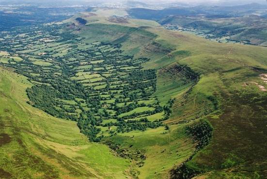
Figure 1: Aerial view of the Olchon valley looking south –west showing the location of Olchon Court.
Previous archaeological work
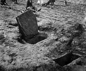
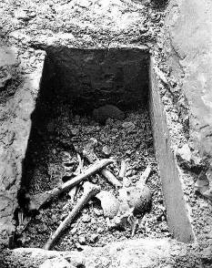
In May of 1932, on land belonging to Olchon Court Farm; two early Bronze Age cists were discovered during ploughing. Both cists contained a beaker and flints together with human remains. These were located approximately 250m to the south-west of Olchon Court. A stone circle and a concentration of early Bronze Age cairns also lie on Hatterall Hill (Olding 2000, 40). It has been argued, from the scarcity of hillforts and enclosures at high altitudes on the Black Mountains, that there was widespread abandonment of upland areas in the Late Bronze Age and Early Iron Age periods (Olding 2000, 56). However towards the head of the olchon valley, a series of earthen and stone built enclosures have recently been recorded. Whilst of unknown date these are clearly multi period, and contain elements not dissimilar to prehistoric enclosures recorded in other upland regions, e.g. Foals Arrishes and Grimspound on Dartmoor.
|


The Parish Church of Llanveynoe is 13th century in origin, however it would appear that the church has become a central place to which a number of earlier carved and inscribed stones have been brought. These include two incised stones which are known inside the church. One is incised with the crucifixion and the other with a crucifix together with the alpha and omega signs and a dedicatory inscription. Both appear to have formed part of a leacht- type altar. A third stone has been erected outside the church and comprised a short-arm cross with a groove cut all the way down the centre of one face. It is thought that the groove was used to pour libations down and that the cross slotted into an altar or was perhaps the marker for the spiritual founder, St. Beuno. The life of St Beuno records that King Ynyr of Gwent granted lands in Ewyas to Beuno around 600AD, and it has been deduced that he therefore founded his first church and monastery at Llanveynoe. The king is then said to have enrolled in the monastery. A fourth stone has recently come to light, built into the wall of a barn about a kilometre further up the valley. This is inscribed with a simple crucifix. There are records of a fifth inscribed stone being discovered in the valley during the 18th century. This , it is said, was broken up and used in the construction of the road.
In 1947 workmen reported finding human skeletal remains during the excavation of footings for a barn, but this was never verified. However the area immediately to the north-east of the reported find spot is an area of field locally known as “the graveyard”. Unconfirmed accounts suggest that “the grave yard” has been attributed to this corner of the field since at least the mid 1800’s. During the Second World War much of the more level land around Olchon Court was ploughed up, this included the area known as “the Grave Yard”. However, ploughing was abandoned in this part of the field due to the frequency and size of stones rendering it impossible to plough.
Since 2002, Herefordshire Archaeology has been running a field survey project in the upper portion of the Olchon Valley. This project records all earthwork and boundary features together with quarries and redundant buildings. Initial results of the data concerning the development of the boundaries in the valley point to a long and very complex history with a small number of cross valley boundaries possibly dating to the prehistoric period.
Olchon Court itself comprises a much altered long house of late medieval date with strong links to the Lollards and later Recusant causes. Its inaccessibility and isolation rendering it a comparatively safe place for the continuation of religious ritual and doctrine banned by the state.
It has long been rumoured that due to its age, dominant location and association by here-say of burials, that Olchon Court sits on the site of an early church / monastic enclosure which would have pre-dated the parish church of Llanveynoe.
Fieldwork in 2009
Fieldwork undertaken in 2009, (HSM 51613), was undertaken by Herefordshire Archaeology as part of a research project with volunteers from the local community. The excavation took place after a series of earthworks were recorded in close proximity to Olchon Court as part of a long running survey project. The site of Olchon Court has long been associated with rumours of burials and is thought to be the possible site of a late 7th century monastic establishment, (although no firm evidence for this exists)
Prior to the excavation a detailed earthwork survey was undertaken during which a low “L” shaped bank was recorded which appeared to run off a levelled area, possibly forming a fold yard or other type of enclosed area. A resistivity survey appeared to support the presence of possible masonry remains on the levelled area and higher than average densities of stone within most of the recorded earthworks.
Initially, two trial trenches were opened within the area of earthworks. Trench 1 was placed in such a way that it cut through a low bank thought to make up a boundary for some form of enclosure, whilst Trench 2 was located in order to run across and off the edge of the levelled platform. Trenches were dug by hand and the turf was cut and stacked in order for it to be replaced at the conclusion of the excavation. It quickly became apparent that Trench 1 cut across a linear feature which appeared to have been created by ploughing in the 20th century. Upon the removal of the turf in Trench 2, a tightly packed stone structure was uncovered. Although only a small area was uncovered, this appeared to be roughly circular with a dry-stone, revetment wall running around its edge and approximately 9m in diameter and survived to a height of 0.65m. To the south of this feature were two large vertically set stones. Further excavation revealed that the two vertical stones were butted by a contiguous line of smaller, vertically set stones and that this line was then joined to the circular masonry feature by a double pitched line of stones. Associated with the soil between these features were a small number of prehistoric pottery sherd, flint flakes and debitage and burned bone. A small patch of burning was recorded in the northern side of the trench. Running under the large masonry structure was a deposit of tightly packed, angular stone suggesting the presence of an earlier structure.
In order to ascertain the opposite side of this feature, two further trenches were excavated. Trench 3 comprised a 1m square excavation which uncovered the north western edge of the circular stone feature although here the rubble was not revetted by dry stone walling but by large vertically set slabs. A fourth trench was excavated further to the north west of Trench 3 in an attempt to intercept further features and or deposits of prehistoric date but none were found.
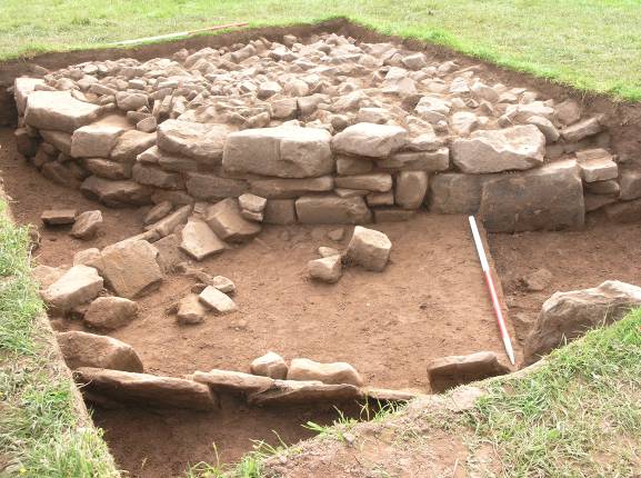
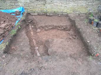
Figure 3: Trench 2 from the 2009 fieldwork, looking to the south-east upon completion of the excavation.
The circular stone structure would appear to represent a well preserved burial cairn of late Neolithic or early Bronze Age date. Interestingly this monument appears to have been adapted in the early / mid Bronze Age by the insertion of a small radial wall of double set stone and the formation or continuation of a “kerb” which does not appear to run parallel to the cairn. Additionally there appears to be an earlier phase of stone monument over which the cairn has been partially constructed, the exact date of which remains unknown but must lie somewhere in the early Neolithic. (Hoverd & Ray, HAS 268)
Fieldwork in 2010
As part of an ongoing project intended to explore and understand the development of Olchon Court and its environs, a small trench was excavated on the southern side of the building complex. The trench was excavated next to the southern face of a south facing wall on the southern side of the building complex. This is the first trench to be excavated on the southern side of the complex. The location of the trench was agreed upon after the owners had expressed an interest in the depth and type of deposits in this area with a mind to possible building alteration. The trench was located close to the edge of a presumed artificial terrace onto which the complex of buildings which make up Olchon Court have been constructed. It was hoped that the excavation would provide information concerning the creation of this terrace in the early medieval period. A site datum was imported from the benchmark on the western gable end of the threshing barn to the north of Olchon Court house. The value for this Bench Mark is 337.64m O.D.
A trench measuring 3m long and 2m wide was excavated by hand through part of a former vegetable patch. The area excavated was located adjacent to a stone built wall which forms part of the southern wall of an open fronted barn that opens onto the courtyard. The wall has a clear construction break which runs vertically from the present ground surface up to a height of approximately 2.3m. The trench was positioned in order to investigate the nature of the foundations of the walls either side of this break.
The shape of the construction break would suggest that the wall to the east of the construction break was originally the southern gable wall for a single storey barn which was aligned roughly north – south. A later wall, (to the west of the construction break), was added to link this building to the house. The north, east and western walls of the north – south orientated barn were then demolished and the former southern gable wall was increased in height to form one continuous wall which now forms the south – facing wall of the east – west orientated open fronted barn.
Immediately below the topsoil (501) was a 5cm thick layer of fairly clean, mid-brown clay (502). This layer was cut in the southern half of the trench by a shallow pit or filled cut (503) which appears to have been associated with late 19th or early 20th century planting. A linear cut (504) which ran on a north-west / south-east axis cut through both (502) and (503). This was 0.4m wide, 0.65m deep and contained a mid 20th century foul water drain (505). Immediately below layer (502) was a 0.32m thick, layer of densely packed rubble, dating from the late 17th to mid 18th century (506). This in-turn overlay the hard natural clay (507).
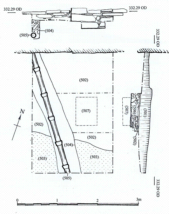
Figure 4: Trench plan with northern & western sections
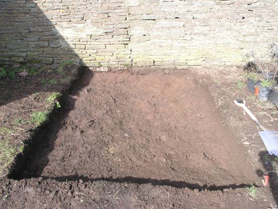
Figure 5: Looking north after removal of topsoil
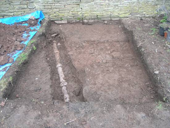
Figure 6: Looking north showing pipe trench (504)
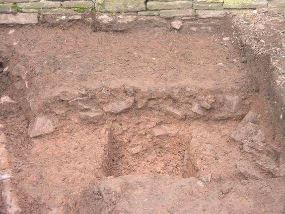
Figure 7: Looking north showing layer (506) with sondage through to natural subsoil.
It would appear that the rubble layer had been purposely spread in order to provide a well drained and level platform onto which a series of single storey barns were erected. It is likely that this sequence represents a period of major re-development of many of the Olchon Court buildings. The archaeological evidence suggests that at least the south-eastern portion of the farmyard was cleared of buildings down to the top of natural subsoil. A 0.3m (1ft) thick base, of well compacted, small rubble was then spread over this area. This formed a layer through which ground water could percolate yet still provided a good surface through which wall foundations were built. This rubble layer had the added benefit of keeping the floor levels and surfaces above it dryer, in an area where too much groundwater was almost certainly a problem for much of each year. A small sondage was dug immediately adjacent to the wall in order to ascertain the depth of foundation. It would appear that the foundation for the single storey gabled building cut through the rubble layer (506) and was founded on the natural subsoil (507).
Site Archive
Archive resulting from this piece of fieldwork:
8 context cards
41 digital images
1 field drawing
1 inked drawing
3 sherds of pottery (context 506)
This document.
Acknowledgements
I would like to acknowledge the support, commitment and hospitality of Anthony Furness and Miriam Griffiths, land owners and custodians of Olchon Court.
List of Illustrations
Figures
Figure 1: Aerial view of the Olchon valley looking south –west showing the location of Olchon Court. Ó Herefordshire Archaeology
Figure 2: Figure 2: Photographs of the cist burials discovered in 1932
Ó Herefordshire Archaeology
Figure 3: Trench 2 from the 2009 fieldwork, looking to the south-east upon completion of the excavation. Ó Herefordshire Archaeology
Figure 4: Trench plan with northern & western sections Ó Herefordshire Archaeology
Figure 5: Looking north after removal of topsoil Ó Herefordshire Archaeology
Figure 6: Looking north showing pipe trench (504). Ó Herefordshire Archaeology
Figure 7: Looking north showing layer (506) with sondage through to natural subsoil. Ó Herefordshire Archaeology
Bibliography
British Geological Survey; England & Wales Sheet 216. Solid & Drift Geology, scale 1:50 000. 1988
Marshall G 1932, Report on the Discovery of Two Bronze Age Cists in the Olchon Valley. Herefordshire Trans Woolhope Naturalists Field Club 27, 147-153
Olding F 2000, The Prehistoric Landscapes of the Eastern Black Mountains, BAR British Series 297, 56
Ray, K. 2001, Archaeology and the Three Early Churches of Herefordshire. The Early Church in Herefordshire, Leominster History Study Group, 99-148
Ray, K & White, P., 2003, Historic Landscape Characterisation for Herefordshire.
Hoverd, T & Ray, K. 2010, Olchon Court, Llanveynoe: A field investigation, HAR 268.
Validation
Herefordshire Archaeology operates a validation system for its reports, to provide quality assurance and to comply with Best Value procedures.
This report has been checked for accuracy and clarity of statements of procedure and results.
Dr. Keith Ray, County Archaeologist
Ref: rs_llv_0051