
Held at: | Private Collection |
Reference: | RS/TCF |
Source: | Guest Contribution |
Title: | Turnastone Court Farm – An Assessment of the Historical, Landscape, Ecological and Agricultural importance of the Water Meadows. |
Place name: | Golden Valley |
Date: | 2004 |
Description:
Introductory Note:
The bulk of the paper below is an unpublished Draft report written by Katherine Stearne of Green Mark International, with others, and prepared as part of a comprehensive assessment of Turnastone Court Farm around the time of its acquisition by the Countryside Restoration Trust in 2003/4. A few figures and maps missing from the draft have been found in material relating to the wider studies carried out at the time, and inserted; some minor edits have also been made for website presentational purposes. Readers should bear in mind the draft status of this paper and exercise appropriate caution in its use. We are indebted to David Lovelace for permission to include this and related material on Turnastone Court Farm on our website.
Ewyas Lacy Study Group
TURNASTONE COURT FARM, VOWCHURCH - WATER MEADOWS | | |
|
|
| |
| ACKNOWLEDGEMENTS | 3 | |
| 1.0 INTRODUCTION | 4 | |
|
| 1.1 THE PURPOSE OF THIS REPORT | 4 |
|
| 1.2 THE BACKGROUND TO THE REPORT | 6 |
| 2.0 THE WATER MEADOW SYSTEM | 8 | |
|
| 2.1 HISTORICAL IMPORTANCE – WATER MEADOWS IN THE GOLDEN VALLEY | 8 |
|
| 2.2 LINKS TO HAMPSHIRE | 13 |
|
| 2.3 HEREFORDSHIRE FARMING BACKGROUND | 16 |
|
| 2.4 PRESENT DAY REMNANTS | 23 |
|
| 2.4.1 Structures with in Turnastone Court Farm | 23 |
|
| 2.4.2 North of Turnastone. | 37 |
|
| 2.4.3 Slough Brook. | 41 |
|
| 2.5 EARTHWORK FEATURES WITHIN FIELDS | 42 |
|
| 2.6 RECOMMENDATIONS FOR FUTURE MANAGEMENT OF THE WATER MEADOW SYSTEM | 49 |
| 3.0 ECOLOGY | 56 | |
|
| 3.1 BOTANICAL INTEREST | 56 |
|
| 3.2 BIRDS | 56 |
|
| 3.3 MAMMALS | 57 |
|
| 3.4 HEDGROWS AND TREES | 58 |
| 4.0 ACCESS & EDUCATION | 60 | |
| 5.0 RECOMMENDATION FOR FUTURE CONSIDERATION. | 61 | |
|
| 5.1 AGRICULTURE | 61 |
|
| 5.2 ECOLOGY | 61 |
|
| 5.3 ARCHAEOLOGY | 61 |
|
| 5.4 ACCESS | 61 |
|
| 5.5 LANDSCAPE | 62 |
| 6.0 SIGNIFICANCE OF THE WATER MEADOWS AT TURNASTONE COURT FARM | 63 | |
|
| 6.1 LANDSCAPE QUALITY. | 63 |
|
| 6.2 TIME DEPTH AND HISTORICAL AND ARCHAEOLOGICAL POTENTIAL. | 63 |
|
| 6.3 CONSERVATION HISTORY | 63 |
| APPENDICES |
| |
|
| APPENDIX A - GRASSLAND MANAGEMENT PLAN | 64 |
|
| APPENDIX B - HEDGROW RESTORATION PLAN | 68 |
|
| APPENDIX C - OUTLINE SPECIFICATION FOR THE RESTORATION OF IRRIGATION IN WEETHS MEADOW | 70 |
|
| APPENDIX D DRAFT CAPITAL WORKS PLAN | 74 |
|
| APPENDIX E SPECIAL PROJECTS | 75 |
|
| APPENDIX F – GLOSSARY | 77 |
| BIBLIOGRAPHY | 80 | |
TURNASTONE COURT FARM, VOWCHURCH - WATER MEADOWS
Acknowledgements.
There are many people and organisations I would like to thank for helping me by giving their time and patience to show and explain things to me. Many local residents have helped in providing information and insights into farming in the Golden Valley. I would like to especially thank Ian Hart, Martin Kibblewhite, Carl Davis, Brian Smith, Mrs John Comyn, and other members of the Golden Valley Studies Group. Caroline Hanks, Keith Ray, Anne Powell, The Library staff at the Museum of English Rural Life Reading, Nicky Smith for survey work, David Lovelace for digitising the maps and Huw Sherlock for archaeological advice.
1.0 INTRODUCTION
1.1 The purpose of this report
This document is the second draft part of a Historic Landscape Conservation plan for the old water meadow fields at Turnastone Court Farm, prepared by Green Mark International. David Lovelace and Huw Sherlock are examining other areas and aspects of the farm. It has been prepared in consultation with Ian Hart of the Countryside Restoration Trust, Herefordshire County Council Archaeology department, and the Golden Valley Studies Group. It should be read in conjunction with the other sections of the plan.
The purpose of this report is to:
· Describe the heritage significance of the old water meadow fields which lie in the river valley, their structures and possible phases of development.
· Provide a balanced assessment of the historical, landscape, ecological and agricultural importance of the water meadows.
· Give a basis for restoration and management plans for the water meadow fields and structures, including general guidelines for the hedgerows.
· Inform day to day management
· Support applications for statutory consents and for grant aid including the Countryside Stewardship scheme.
There is no set format for Historic Landscape Management Plans for water meadows. Plans have been prepared for water meadows in the past, but depending on the consultants’ background they have tended to concentrate on either historical or ecological significance, and a balanced view has been difficult to achieve (Stearne 2004). Water meadow landscapes do not fit easily in to the guidance given by J.S. Kerr and English Heritage (2000), as there is usually little documentation about specific water meadow sites. They are not Parklands, which usually have been landscaped by specific owners and usually well known designers (such as Capability Brown) at particular points in time: they are living, working agricultural systems that have been developed and adapted over time by generally unknown, undocumented farmers or farm workers seeking just to make a living.
However, the principles given by Kerr have been followed which include:
· Understanding of the site
· Assessment of significance
· Discussion of issues
· Formulation of policies.
Historically there have been few documentary references to water meadows at Turnastone Court Farm apart from the book by Rowland Vaughan in 1610. Estate records and farm sale records give a snapshot of events at Turnastone Court Farm at set points in time. The British Library, the Library at the Museum of English Rural Life in Reading, Hereford Record Office, Herefordshire County Council, Hereford Library and English Heritage at Swindon hold information pertaining to the area and the history of water meadows. It has not been possible to consult (or find) all the documents that may have a bearing on Turnastone Court Farm within the time available for this report. The recurrent theme of this plan is the need for further research to develop a full understanding of the site. Archaeological Survey work has been carried out by qualified field archaeology survey contractors.
Nature conservation survey and assessment has been carried out under David Lovelace.
Cultural significance has been assessed on the basis of the following:
· Ability to demonstrate features of cultural significance
· Important themes in cultural history
· Physical features that reflect important trends or events
· Associations with events or individuals of importance
· Aesthetic qualities, both in terms of present day values and the culture that produced them.
1.2 The Background to the report
Turnastone Court Farm is a 249 acre (100ha) grassland farm on which it is generally believed the majority of valley fields have not been ploughed for 400 years. It was purchased by the Countryside Restoration Trust in January 2003 with the aim of saving the farm from agricultural intensification. Robert and Chrissy Fraser are the Tenants, building up a herd of traditional Hereford Cattle with the aim of having 50 breeding females. They also breed Ryeland and Shropshire sheep working towards a flock of 150 ewes plus followers.
The Farm was entered into the Defra Countryside Stewardship Scheme in October 2003 with the objectives of retaining and enhancing the landscape, ecological and historical interest of the farm. To this end a Historic Landscape Restoration Plan has been commissioned to be under taken by Green Mark International, David Lovelace and Huw Sherlock.
Turnastone Court Farm, Vowchurch, lies in the Golden Valley in Herefordshire, (Grid Reference SO358364) beside the River Dore, which rises in the parish of Dorstone and flows south east to join the River Monnow at the south end of the valley. The soils in the valley are reddish brown till of the Dore Soil Series. They comprise deep free drained reddish brown stoneless soil developed from wash silts of the Wye Glacier. There are lenses of brown silt and fine sand (Palmer 1972).
Most of the tributary streams of the River Dore originate on the west side of the river valley with the Shegear and Slough brooks running through Turnastone Court Farm land. In 1610 the owner of Poston Court, Rowland Vaughan, published a text claiming to have invented a surface water irrigation system to increase the productivity of the grassland in the valley. Whether Rowland Vaughan was the first person to construct water meadows and how much of the valley was irrigated in 1600 is open to debate. However there are clear remnants of water meadows systems on Turnastone Court Farm.
2.0 THE WATER MEADOW SYSTEM
2.1 HISTORICAL IMPORTANCE – Water Meadows in the Golden Valley
World wide, surface water irrigation has been practised in China, Egypt and the Middle East since ancient times (Newson 1992 ch1). How managed flooding of land first came about and how English water meadows developed are difficult to determine. Monasteries such as Fountains Abbey (Cook, Stearne & Williamson 2003) and Buildwas Abbey (Brown 2002) probably operated simple forms of water meadows in mediaeval times. However references to water meadows pre 1610 (Fitzherbert 1535 & Moorhouse 1981) and remnant earthworks are few and far between. In 1535 Fitzherbert describes the technique of creating an artificial water meadow, but little detail the are other references to wet meadows but it is difficult to determine whether they are referring to artificial surface irrigation or naturally flooded land valued for summer grazing in the river valley (Stearne 2004).
Rowland Vaughan lived at Vowchurch between about 1580 and 1615. In 1610 he published his book ‘Most Approved and Long Experienced Water Works’. This is a very significant and important book, because it is the first clear and most detailed reference to water meadows in England. In it, among other things, Vaughan claims to have independently invented water meadows after seeing how well the grass grew in spring where a mole had burrowed through the bank of the river to allow the water to flow over the land. He describes excavating a ‘canal’ and the system of irrigation. Vaughan was prone to self-publicity and some of the works described in his book may be exaggerated or even fantasy, such as the ‘commonwealth’ he describes. However there are earthworks in the Golden Valley that are very similar to those described in his book so it seems likely that he carried out at least some of the work he describes. Whatever the case, it is obvious that by about 1600, Vaughan and maybe others were experimenting with moving water over graded land, with the intention of producing both reliable hay crops and early grass.
Vaughan claimed that the rental value of his land went up from £40 per year to £300. However there are no comparable values or references so this may have been an exaggeration, as he seems generally to have been prone to over-state his case. ‘His Book’ discusses the Trench Royal at length and the remnants of this are still clearly visible on the ground. The sluices where it was fed from the River Dore are only just visible [see photograph 12 section 2.4] and the railway, which opened in 1881, cut this source of water to the Trench Royal. For part of its course the Trench Royal water still flows through Poston Court Farm fed with water from the Trenant Brook. A weir where the trench enters Turnastone Farm now allows water to flow back to the River Dore; see photograph 7 section 2.4
The line of the Trench Royal is visible across Turnastone Court Farm apart from where it follows the same route as the road, through the village. The road appears on a map of Whitehouse dated 1812. This road was widened in the twentieth century and the Trench Royal piped under the road (local resident Headley Wilding remembers having to pull cars out of the trench when they went round the corner too fast). L. Bletchly (1982) asserts that the fields below Whitehouse (in the Slough Valley) were artificially flooded within the memory of her father Arthur Seward Wood (1880 – 1968), and remnants of wooden and stone sluices are still visible today (see photograph 16 and photographs 1 and 4 respectively section 2.4 )
The diagrams of Vaughan’s water meadow systems that were included in his book have been lost, but the system within the Golden Valley is a complex system of channels, catchwork and bedwork systems. The diagram attached to copies of his book in the British Library seems to be an idealised illustration of his ‘Common Wealth’ and not his water meadows system. Deeds show that Rowland and Henry Vaughan exchanged five and a half acres of land in Snodle for a similar area at Dorstone in 1609. The latter was near the ditch or ‘gutter of water’ (Delorme 1989). That is not to say that all the water meadows at Turnastone Court Farm are contemporary with Rowland Vaughan, as the systems may have been ‘remodelled’ at a later date.
‘His Book’ discusses at length the Trench Royal (main carrier), how it should be graded and the need to level the land, to ensure an even flow of water, but does not go into detail about the agricultural aspects of the system; i.e. watering regime and grazing. Vaughan appreciated differences between sandy and clay soil, when irrigating, stating that the sandy soils can take more water than the clay soils. He also prized the muddy water of winter for its ‘fertilising’ qualities. Vaughan irrigated or ‘drowned’ the land in the winter and drained in March and April. He discusses the vegetation changes from moss, cowslips and other ‘weeds’ (evidently a diverse ecosystem) to profitable grasses under his management. The land was grazed by cattle to the beginning of May and then irrigated again for a hay crop. He claims to have taken a second crop of hay, prior to grazing in the autumn, reporting that the land can only be drowned for short periods in the summer; hours or minutes, as opposed to weeks in the winter, recommending drowning at night in the summer because if ‘drowned’ too long the grass suffers a ‘malaise’. Here Vaughan is most likely recognising the effect of anaerobic conditions building up more rapidly in the topsoil in the summer than winter, due to the lower oxygen content of the water and the higher respiration rates of the vegetation in the summer, to the detriment of the herbage. He mentions sheep and discusses dairy cattle at length, but fails to record which animals grazed the land in the spring or autumn.
Table 1 has been produced to illustrate the annual cycle of management after Vaughan (1610). Vaughan only outlined the irrigation and grazing management. He may have felt the day to day management was common knowledge and needed no explanation.
Table 1 Water meadow management in 1600 after Vaughan
| Season | Operation | Quotation |
| Winter | Irrigate with ‘muddy’ water | as it riseth muddy, imploy it on your grounds during the winter season page 96 drowne the frozen grounds when the snow begins to fall:. so shall you release the grasse being bound and spend the snowe ……page 119 |
| Spring March /April | Drain Graze sheep or cattle | be sure in the begininge of March to cleare your ground of cold water; and keepe it dry… page 97 that all kinde of cattle, (sheepe especially), may have sufficient to sustain them page 120 I can graze my mowing meades until the first of Maie page 127 |
| May | Irrigate a day | In May…….. You need not drowne it until a day, two or three before you mow Page 98 |
| June | Hay - one or two cuts | you shall finde this manner of drowning in the morning of your mowing so profitable and good that commonly you gaine ten or twelve days advantage in growing page 99 drowning before mowing, will make good a second mowing page 100 |
| Summer | Irrigate overnight Cattle graze for two weeks at a time | You may suffer colde water in the heate of the summer to cool your grounds Page 97 In Summer drown it moderately’ page 120 Not drowne in the heat of the day, but in the night sunne to sunne page 137 Cattle grazing for two weeks page 127 |
| Autumn | Irrigate with muddy water | in flood times see you suffer not your floud water by neglect to pass away into the brook …..but by your sluice command it to your grounds;… so long as it appears muddy page 96 |
Source Vaughan (1610)
2.2 LINKS TO HAMPSHIRE
Vaughan’s book was dedicated to the Earl of Pembroke who had estates at Wilton near Salisbury, and there has been speculation about transfer of water meadow irrigation technology between the Golden Valley and the Avon Valley (or visa versa) (Bettey 1999). No evidence has been found to date to confirm this, apart from Vaughan’s dedication. The first clear documentary evidence for water meadow construction on the Wilton estate is at Wylye in 1632, (more than 20 years after Vaughan’s book was published). ‘The men of Wylye hired John Knight of Stockton to water the common Meadow’ (Kerridge 1967). It seems from this that the practise of watering was already well understood (Bettey 1999).
There is circumstantial evidence for links between the Golden Valley and the Wey Valley water meadows (on the Sussex /Hampshire/ Surrey borders). Vaughan mentions that several gentlemen came to see how his water meadows worked. One of the visitors was Mr Worlidge. Could this have been Stephen Worlidge of Petersfield (died 1635 buried in St Peters Church Petersfield), the grandfather of John Worlidge who published ‘System Agriculture’ (Worlidge 1669)? In this book, Worlidge expounds the virtues of water meadows in similar enthusiastic language to Vaughan. He writes at length about various ways of raising water by artificial means, such as the ‘Persian Wheels’, a rotating manually operated device with buckets for lifting water. He suggests that this should be practised on the River Wey at Godalming. Seebohm later suggests; ‘There is little reason to suppose that these devices came into general use’ ( Seebohm 1927), just as we have little evidence to confirm the existence of ‘Commonwealth community’ that Vaughan envisaged in the Golden Valley.
Rowland Vaughan owned an iron foundry at Peterchurch and may have met other landowners with similar interests during visits to London. The Wey Valley was a centre for iron working in the fourteenth and fifteenth centuries, with ‘hammer ponds’ at for example Waggoners Wells and Hammer Vale nearby. John Hooke, was Lord of the Manor of Bramshot and a member of a wealthy land owning family; iron masters who dominated the area during the 1600s. They may well have initiated and co-ordinated the construction of water meadows in the Wey Valley at Bramshot and Liphook. From the Bramshot Court Rolls we know that in 1625 John Averie was granted permission to sublet his land in Bramshot provided the lord of the manor had use and profit of the water and water courses and the right to scour out and repair ‘the ditches and banks now made or later to be made for the watering of meadows’ . (Bowles 1988).
The truth is likely to be that innovative landowners were meeting in London and discussing new ideas for improving their lands (and other businesses), then trying them out to a greater or lesser extent on their own lands. John Hooke and John Worlidge being of a more equal social standing to Rowland Vaughan than the Earl of Pembroke, are likely to have met Vaughan when visiting London.
Sir Richard Weston was also constructing water meadow systems on his estate at Sutton Place, on the River Wey near Guildford, in the first half of the seventeenth century (Weston 1650; Currie 1996). It seems he sent to Hereford for someone to help him lay out water meadows.
In a legal enquiry in 1631 concerning land affected by Sir Richard Weston's 'New River' of 1618 one of the witnesses was a John Harper of Hereford, esq., then aged c. 52 (i.e. born c.1579), who said that he had disbursed some £1,000 from Weston in making the' river'. The Harpers were squires of Amberley in Marden, just North of Hereford and were cousins (fairly distant) of the both the Vaughans and Parrys. A rather younger John Harper b. 1586 lived at Chilston, the neighbouring parish to Vowchurch, in 1634, but more direct connections have not yet been proved.
Physically the Golden Valley has more similarities to than the Wey Valley than the Avon Valley. They are both relatively narrow with complex mixtures of water meadow systems varying from catchworks to bedworks. Whereas the Avon valley has a wide valley floor with large bedwork systems set out on the valley floor. The River Avon is a chalk stream with relatively even flow winter and summer. The Wey and Dore rivers are not chalk streams and are spaty with potentially sudden changes in flows and water levels. The water supply to water meadows in the Wey and Golden Valleys are often supplemented with water from springs whereas the Avon water meadows are predominantly fed by carriers from the main river.
So, there is more circumstantial evidence for the transfer of water meadow technology from the Golden Valley to Hampshire via the River Wey, than via the Wilton Estate (owned by Lord Pembroke). The link between the Golden Valley and The Wey Valley is worth pursuing especially if more information about John Worlidge and his family is found.
2.3 HEREFORDSHIRE FARMING BACKGROUND
The Golden Valley, as most of Herefordshire, has had a mixed farming economy since the fifteenth century until very recently. This may have saved it form the worst effects of various agricultural depressions over the centuries. Progress in agriculture is commonly assessed by the rate of technological innovation, and as Rowland Vaughan’s Book of 1610 proves, the Golden Valley was at the forefront of innovation in the late sixteenth and early seventeenth century. It has been suggested that when Vaughan sold the land in 1616 the water meadows became disused. That may have been the case on more complex parts of the system, or areas difficult to maintain. However, early grass, reliable hay crops and good autumn grazing would be invaluable to a tenant stock farmer rearing sheep and cattle. Once the system had been laid out, with weirs and sluices constructed, the maintenance costs would be relatively small compared to the value of the grassland products. Often stressed by early texts about water meadows is the value farmers put on the reliability of the hay crop from water meadows.
It may have been that early water meadows, in the fifteenth and sixteenth centuries (1400 – 1600), were managed for hay and cattle. Indeed the earlier writers (Fitzherbert 1535; Vaughan 1610) stress the hay crops while very little mention is made of either sheep or cattle. A good reliable hay crop determined the number of animals that could be kept through the winter. The method of surface irrigation ensured that the first cut of hay was both abundant and good quality. The irrigation of grassland water meadows mitigated the problem of variable weather conditions that hay cropping on dry meadows was so dependent on. Rowland Vaughan also suggests that he can gain a good income by selling the hay off his water meadows.
Vaughan (1610), Blith (1653), Weston (1650) and Worlidge (1669) appear to be the only contemporary published texts about water meadows in the seventeenth century. The lack of published texts on water meadows between 1687 and 1779 probably reflects limited literacy among the population. We know that the ‘craft’ of the drowner was well established. Bettey (1999) refers to Henry Phelps of Turners Puddle, ‘a known ancient, able and experienced waterman’ who was sent for to supervise the construction of new water meadows on the River Stour in 1659. Drowners, to some extent, made ‘mystery and art’ out of drowning. They were well-respected members of the farming community, like the shepherd or the miller and their knowledge was passed on orally and by apprenticeship (Seebohm 1927). Where possible the ‘craft’ of the Drowner was passed from father to son, as their standing and pay was at least that of the shepherds. (In the region of £3 to £4 annually, whereas the common farm worker would be paid £2 to £3 annually (Seebohm 1927). These men may or may not have been literate, but they would have no incentive to record their working life.
Water meadows were constructed in other Herefordshire river valleys; a large system of irrigated meadows was constructed in the vicinity of Staunton-on-Arrow in 1660 completed in 1710 and still in use until after the Second World War. Catchwork meadows along the sides of valleys were widespread by the 1790s. So it would be simplistic to think that just because they were not written about the water meadows in the Golden Valley were not operated. In some ways it is unfortunate that the ‘myth of Rowland Vaughan’ was so strong because it over shadows all other water meadows work in Herefordshire. The Rev. Wright writing in 1799 remarked (about Gloucestershire but I believe that the same holds true for Herefordshire) that Mr Marshall and Mr Turner[1] say little or nothing of:
‘this very extraordinary method of fertilisation tho’ it has prevailed there for more than a century. Mr Marshall has not even hinted at the practice, and Mr Turner has mentioned it in a way that makes it appear insignificant’ (Wright 1799 p5)
Clark (1794) only mentions water meadows in passing:
‘Although the Wye is too haughty to yield the husbandman’s wish, by submitting to be turned over his meadow, yet there are other streams more humble and more useful, that are quite tractable, from whose invigorating streams the farmer derives no small portion of wealth’ (Clark 1794 p 12-13).
He mentions water meadows on the River Arrow, but not the Golden Valley, stating:
‘the water of the Arrow is found to be uncommonly beneficial to the land over which it is turned ’ and many thousands of acres of rich meadows are flooded (Clark 1794 p13).
Even in 1805 when a review of the county of Herefordshire was commissioned from John Duncumb, Secretary to the Agricultural Society of Herefordshire, writing about the value of water meadows in Herefordshire he repeats almost word for word Vaughans book written two hundred years previously.
Herefordshire was mainly a mixed farming county. No documentary evidence has been traced by this study to confirm that the sheep corn system operated in Herefordshire in the sixteenth century. However, it is likely that it operated in the Golden Valley along similar lines to that in Wessex as described by Bowie (1987). As part of this integrated system sheep grazed valley meadows in spring and were folded on arable land at night to manure the corn land. Although not noted for corn production, the farmers in Herefordshire would have grown as much corn as they needed for home consumption at times when the corn price was high. The sheep would have only grazed on the water meadows in the spring after which some meadows would have been shut up for hay as described by Vaughan. The after math grazing would have been cattle. This system cleverly broke the cycle of the liver fluke parasite, which affected the sheep.
High corn prices during (and after) the Napoleonic Wars (1790 –1805) may have made it economic to plough up some of the water meadows that were difficult to irrigate, or in a poor state of repair. This would have also enabled establishment of new grass leys.
This lack of information may be because the operation of water meadows was considered common knowledge, having been operation in the county for over 100 years. Writers assumed that readers/ farmers knew about water meadow operation. The books were partly trying to encourage new technology (i.e. breeding of animals was very much under discussion at the beginning of the nineteenth century and cattle are very important in Herefordshire).
There is little information on water meadow management from the early eighteenth century. However towards the latter part of the eighteenth century England became more isolated from Europe, due to the French Revolution (1789) and, this was soon followed by the Napoleonic Wars. During these Wars, trade links with the continent were severed (Kerridge 1954b) and there was no importation of foreign cereals (Atwood 1964). This coincided with a rise in population, so increased home production was important (Kerridge 1954b). The Government of William Pitt took on a siege mentality, a situation similar to the ‘dig for victory’ in the twentieth century world wars. Prompted by agricultural advances throughout the seventeenth century, the Board of Agriculture was formed in 1793. This was an example of interventionism by government in agriculture, for example in 1802 a premium was offered for irrigation:
‘to the person who shall in a county where irrigation is not generally in practise, water the greatest number of acres and in the completest manner’ (Young 1787).
Pre-1700 the difficulties for Hereford agriculture were not lack of agricultural innovation but poor transport. In 1700 Bristol was the chief market, where prices were as high as anywhere outside London, taking grain, cider and wool; but it was difficult to navigate the Wye and very bad roads raised transport costs. Canals especially the Hereford to Gloucester canal completed in 1790 (with the main aim of reducing and stabilising the price of coal brought into the county) improved transport links for the farmers’ produce. London took cattle and better quality cider, which could bear higher transport charges. Sixty tons of wool was sent from Hereford July Fair to Gloucester via the canal at the end of the eighteenth century and Gloucestershire clothiers had warehouses at Hereford and Ross. Other exports from the county were bacon pigs, cooking apples and Herefordshire cattle, providing beef for the growing urban markets of Manchester and Birmingham as well as London. The beginning of the nineteenth century also saw a significant area of woodland felled and the land converted to tillage when the grain price was conducive to this (Jones 1961).
The coming of the railway in 1881 made it easier for farm products to be sent to market.
In 1879 Poston Court Estate was sold and Turnastone Court Farm let to John & Selina Probert yearly, with a Candlemas tenancy valued at £355 per annum. (Tithe Rent Charge £42 11s 5d per annum). Then the farm was sold again in 1912 to the tenant Mr William Watkins who had a yearly Candlemas tenancy valued at £246 10s 0d per annum. (Tithe Rent Charge £32 10s 11d per annum, the sum actually paid for 1911 was £23 5s 2d: times were hard!!).
The change from tenant to owner-occupier, which happened throughout the Golden Valley between 1890 and the 1920s, was significant as the tenants had no security of tenure. Farming was in a depression during the latter part of the nineteenth century. The First World War gave higher farm incomes (though difficulties of working the land were severe as many workers left to go to war or died during the flu epidemic of 1917/18) into the 1920s when again farming went into depression until the Second World War.
It is likely that as in Hampshire milk became an important product of farming in the Golden Valley in the late nineteenth and early twentieth century especially following the opening of the railway. Dairy cows are likely to have grazed the valley meadows at Turnastone Court Farm near the buildings for ease of daily milking. The need for reliable hay crops reduced through the twentieth century, as cattle feed became more readily available.
Most farms in the 1920s had a small dairy herd. The Court at Dorstone used to send milk to Cardiff by rail - over 30 gallons of milk a day in 1931. More locally the Farmers wives could use the railway to travel to Hay Market on Thursdays where they would sell butter and cheese, including sheep’s cheese that they made; poultry and eggs would also be sold. Passenger services on the Golden Valley Railway branch line stopped in 1941 for the duration of the Second World War.
Sheep have always been an important part of the economy of the area though mainly on the upland areas of farms. Sheep would be brought down to the farm for lambing and shearing. One or more of the sluices at Turnastone Court probably doubled as a sheep wash as the sheep were driven through water to wash the fleece before shearing.
Mechanisation during the twentieth century was also significant. One of the first tractors in the valley was a Fordson Tractor at Bage Court Dorstone – 1919. The tractor made it possible to reclaim large neglected and derelict areas on the higher land. During the second war Allis Chalmers tractors were assembled lower down the valley at Bacton. It was not just the tractor but also the combine harvester which made significant changes to the need for labour on farms. Threshing with a threshing drum could take up to 16 workers and last from 10 day to 2 weeks on the bigger farms. The last threshing carried out at Dorstone by a threshing drum was about 1965 at top of Vagar Hill and apparently the drum is still there next to the telecommunications masts (Jones 1990).
An incident from the Second World War is well remembered by older villagers. The War Agricultural Committee (or the War Ag. as it was commonly known) ordered Mr Watkins to plough up some of his grassland fields. He defied them by standing in front of the gate to a field saying ‘over my dead body’. This is generally used as evidence to support the common belief that the meadows at Turnastone Court Farm have not been ploughed in the Twentieth Century. The story though true, may actually explain more about the local politics between Mr Watkins and the War Ag. than the management of the fields. Similar incidents happened though out England. The novel ‘Shameful Harvest’ by A, G Street (1951) is about such relationships. The dedication at the front reads;
‘To the memory of George Raymond Walden of Itchen Stoke Hampshire, who lost his life on July 22, 1940, while resisting eviction from his home at the order of the Hampshire County War Agricultural Committee’ Street 1951.
There are numerous stories about the War Ag. issuing ploughing orders for unsuitable land or being defied by farmers. People remember dramatic incidents such as the one described above but forget the common place of a tractor ploughing at a different time. The water meadows could well have been ploughed by Mr William Watkins during the First World War.
Many water meadows ceased operation between 1900 and 1920 because of the lack of labour to work them as men went away to the war and rising wages for farm labourers, which made them uneconomic to irrigate. Much land was ploughed during the first world war as during the Second world war to be returned to grassland in the 1920s (Stearne 2004).
The hours of work until the Second World War were 6am to 6pm in summer (or more during for example harvest time): In winter dawn to dusk.
Table 2 Weekly Wages for Farm workers 1890 -1989
| 1890 | 12s.0d. | 60p |
| 1913 | 17s. 6d. | 87p |
| 1939 | £1.10s 0d. | £1.50 |
| 1952 | £5. 0s. 0d. |
|
| 1965 | £10. 0s. 0d. |
|
| 1977 | £44. 0s. 0d. |
|
| 1989 | £112. 0s 0d. |
|
During the Second World War there was a prisoner of war camp nearby, on the Cwn Road out of Dorstone. Italian and German men from this camp helped with farm work, some of them are remembered as good workers. There was obviously a rapport between some of these POWs and the community in the Golden Valley, as some them remained after their fellows were repatriated (Jones 1990). Evidence from the buildings at Turnastone Court Farm shows POWs did work on the Farm. It is likely that they also carried out some of the repair work noted on the sluices, for example the concrete sills that would be difficult and costly to install. It is unlikely that these repairs would have been put in at times of economic depression (the first half of the twentieth century before the Second World War), or after the end of the war when the meadow irrigation was not a priority. However if there was cheap labour (in the form of POWs) then it is the kind of work they would be asked to do. While it is uncertain that the water meadows were irrigated up to the Second World War. There are other good reasons to keep the sluices in good repair. Sluices A, B, and D control the water levels in their respective watercourses. The low concrete wall at sluice A would have been constructed after a flood event that eroded round the sluice. It is probable the concrete sills were installed around the same time, but by different workers. The concrete wall is a fairly crude construction, whereas the sills are carefully fabricated.
It would be to the farmers’ advantage to retain a reasonable level of water in the brooks at times of low flow in the summer for animals to drink from and sheep washing. Also if erosion is allowed to undermine or bypass the sluices then there are serious concerns about increased rates of erosion. This would not only affect the land belonging to Turnastone Court but also neighbours.
2.4 PRESENT DAY REMNANTS
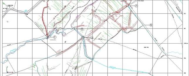
A plan of the water meadows at Turnastone Court Farm showing watercourses and features with relevant reference numbers is given below in four overlapping sections from north to south. The various features and locations marked are referred to throughout this report; a higher definition, zoomable version of the entire plan can be downloaded here for more detailed study if required.
Plan of the Water Meadows

Section1 [North]

Section 2
Section 3

Section 4 [South]
There are the clear remains of four sluice structures (at locations A, B, C &, D) within the bounds of the farm. At locations A and B there are concrete sill weirs. Also noted is some undefined stone work in the return stream for the Trench Royal (at point E). At location D there is a curious ‘hole’ in the existing stone work. At ‘F’ there are some stones in the bank of the Trench Royal, but these may not be of significance.
Further upstream towards Peterchurch are bridges, weirs and old structures worthy of note. In the Slough Brook towards the White House there lies the remains of a wooden structure, but outside the bounds of Turnastone Court Farm.
A local resident (Carl Davies) reports seeing a wooden structure in the River Dore close to Poston Court Farm, but this is not detailed in this report.
2.4.1 Structures within Turnastone Court Farm.
Location ‘A’ – field 6717.
The water flowing through this stone built structure is that of the Slough Brook. There is clear evidence (debris on the grass and in the hedgerows) that this stream rises (and falls) substantially (about 1 meter at times) during wet weather.
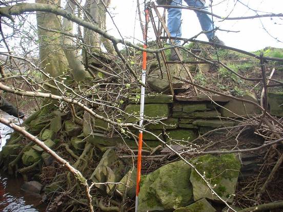
This is the best-preserved structure at the farm. It may be possible to place wooden boards within the sluice to raise the water level in the brook. The stone work is consistent throughout the whole of the structure suggesting that it is in the form in which it was built. (This does not confirm that it is part of the original Vaughan water works). At some time following the original construction of the sluice additional elements have been added.
Photograph 1 shows a view of the sluice looking up stream. The weir is formed by the bottom sill of the sluice, which is constructed from concrete. The surrounding stone work is in very good condition. A threat to this structure are the trees growing near by, as their roots will undermine and disrupt the stone work so these trees should be removed. Roots can be seen invading the sluice sill. Unfortunately the sill is cracked through and water is undermining the sill; this needs to be prevented. Two areas of undermining are noted under the support wall close to the sluice. Repairs are required.
Photograph 1. Sluice at Location ‘A’.

A wall about 7.0 m long has been built out into the field. Its function is not certain, but it may have been to prevent the stream flow eroding around the sluice at times of high water flow, or part of a sheep wash.
Photograph 2 shows a more general overhead view of the structure and the close proximity of the public footpath and bridges. Also shown is the wall extending out to the right into the field. This is a very large water meadow structure; the scale can be judged from the spade and ranging pole in the photograph. A feature not seen at times of high water flow are the stones neatly placed on edge, upstream and adjacent to the sill.
Photograph 2. Sluice at ‘A’, aerial view.

Another section of wall (concrete) was built along the bank just up stream of the sluice and it is clear that this has been built to stop the stream eroding away from its correct course. If irrigation of the adjacent fields is to be carried out the height of this concrete wall will have to be increased. (This suggests the wall was built after irrigation of the fields was no longer practised).
Photograph 3 shows the more recently built revetment wall. It is of very functional appearance being made of concrete formed with corrugated iron sheeting.
Photograph 3. Concrete wall at ‘A’.

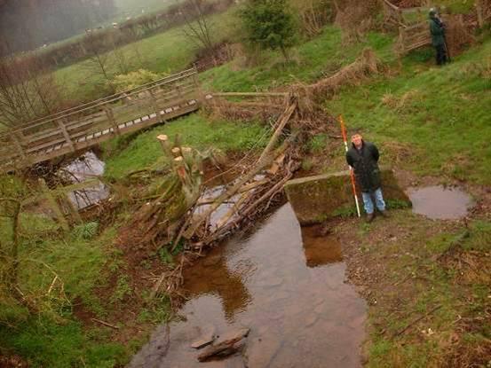
A beautiful stone built bridge is located just down stream from the sluice. The actual bridge is in reasonable repair but there is bulge in the wall just up stream, which would be difficult to rectify, but should be stabilised if possible. In the NW corner of the bridge the supporting wall needs some attention to prevent collapse.
This bridge is the only crossing to enable access to field no 4585. A hay crop should be taken from this field each year. The bridge is constructed of only a single layer of bricks. Whilst the bridge looks to be in serviceable condition it was never built to cope with modern farm machinery. (A modern tractor may weigh 3-5 tonnes compared to a large carthorse of only one tonne). It is recommended that another crossing is installed for example a bailey bridge to reduce the stress of traffic over this bridge. An alternative is to build a bridge over the top of the stone bridge, which saves the effort of replacing gates and fencing.
Figure 2. Diagram of layout at Sluice ‘A’.

Very little of the structure remains and there has been considerable erosion around the area, especially where the stream turns a right angle.
One wall of the sluice remains with the slot for the wooden boards clearly visible. The bottom sill is in very good condition, but its full extent cannot be determined because of tree roots. The material used to construct the sill has not been determined but is probably cast concrete slab. Bricks can be seen west of the sill in the supporting wall suggesting repairs at some time in the past.
Photograph 4 shows the sluice and the sill can also be seen. Again this is a large sluice as can be scaled from the spade in the photo. Due to erosion most of the water flowing along the stream flows around the side of this structure.
Photograph 4. Remains of sluice at location ‘B’.

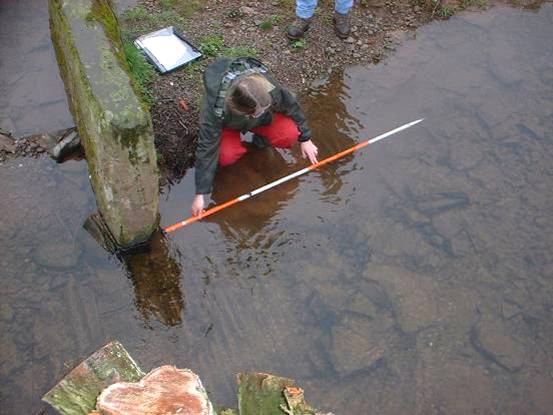
Little of the actual sluice structure remains. However, under water can be seen the line of the old sluice wall. This is not easy to photograph due to the water but in photograph 5 the line of the wall is shown using a ranging pole.
Under water and in line with the standing stone there is a brick sill. Looking at the size shape and form of the brick it would seem that the sill is a result of restoration works. The brick design suggests a date of about 1880, which coincides with the construction of the house, which made from very similar bricks. Careful study of photograph 5 shows the underwater bricks in line with the standing stone. Downstream of the sill is a short length of cobbles (local stone embedded on edge in the streambed) installed to stop erosion, and again these can be seen in the photograph.
Photograph 5. Showing line of sluice wall at location ‘C’.
The most notable feature of this area is the very large standing stone which can be seen in photograph 6. The need or reason for this stone is not clear and it is possible that it has little to do with water control, other than being an attempt to stop erosion. There has been some mention (local opinion) that once the farm had a sheep wash and this might be the location, the standing stone possibly being used to make part of the sheep wash basin.
There is an old fence adjacent to the stream in this area as seen in photograph 6. This should be relocated, with a water gate provided, to prevent animals walking up stream. The tree growing above the remaining sluice structure also needs to be removed.
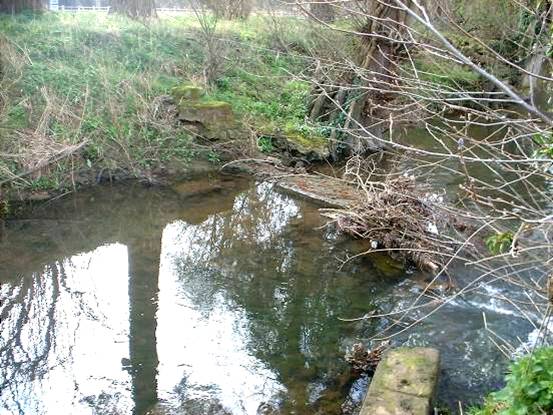
Photograph 6. Remains of sluice at location ‘C’. Aerial view.
At this point the existing flowing section of the Trench Royal enters the farm over a beautifully constructed weir. Many interesting features can be noted at this location. A general view is shown on photograph 7.
The sill of the weir is formed of a large concrete slab and seems to integral with the stone works. This weir is NOT perpendicular to, or in line with the Trench Royal. Most of the stone work either side of the weir is in good condition, but does not show any form of sluice where wooden boards could have been put into the structure, so it would seem the level of water was not adjusted but may have been controlled over the weir. It was noted that water is under-mining the sill and this needs urgent attention. Concrete is very difficult to date – even the Romans laid concrete. However its common use began during the Victorian era.
Photograph 7. Weir at location ‘D’.

Along the structure beside the line of the silted up Trench Royal there seems to be a ‘hole’ in the wall to allow the Shegear Brook coming from the springs above, to drain away. It is difficult to say if this aperture is deliberate. The stone work is this area is fragile and needs urgent attention to prevent further collapse. Photograph 8 shows this feature.
Photograph 8. Aperture in stone work at location ‘D’.

On the other side of the weir is the very obvious remains of a sluice structure. Digging away the soil cover at this location has revealed a brick sluice sill. The form of the brick (being very large: 9.5 inches by 5 inches by 3 inches), suggests a date of about 1830, which indicates the date of possible restoration work. (In 1760 a tax on bricks was introduced. Since the tax applied to each brick the size of bricks was increased to reduce the number of bricks in a building. To counter this, a double brick tax was introduced for bricks over 150 cubic inches. The brick found in the sluice sill has a volume of 143 cubic inches suggesting it was designed to avoid double brick tax – thus its date might be post 1820. Most bricks after 1830 were smaller and had a hollow in the top, the ‘frog’, so this might suggest these bricks are pre-1830.) The direction of water flow through this sluice has been the subject of much debate but it is almost certain the flow was in the same direction as the Trench Royal. Old maps suggest a water meadow supply ditch in the field of the adjacent farm, and this sluice would have been used to control water level for irrigation in the neighbouring field. Photograph 9 shows the dug out sluice sill.
Photograph 9. Sluice with brick restoration, now buried. Location ‘D’.

Under the foot bridge over the Trench Royal the stonework shows two distinct types. At about the level of the water and below, the stones are thin and finely prepared. Above this level the stones are much larger and not so well laid. This indicates restoration works at some stage. The end of the stonework on the Turnastone side of the watercourse under the footbridge is in danger of collapse and in need of urgent attention.
Figure 4. Diagram of layout at Sluice ‘D’.

Location ‘E’ – field 6282.
Along the stream carrying the water from the Trench Royal back to the river is a very dilapidated structure. It may be the remains of an old sluice. Photograph 10 shows the remains and it can be seen that the construction style is very similar to other structures on the farm.
Photograph 10. Remains of stone structure at location ‘E’.
In the bank of the Trench Royal there are some stones that have the same general appearance of those used in the construction of other structures on the farm. There would seem to be little reason for these stones to at this location other than to strengthen the bank, preventing erosion or soil slippage. It is possible the stones have been ‘robbed’ from elsewhere on the farm.
Photograph 11. Stones in bank of Trench Royal at location ‘F’.

A few very small holes have been dug along the line of the Trench Royal. At each location stones have been found in a distinct layer a short distance ( 0.3m) under the present bottom of the trench. Vaughan tells us in his book that there is a problem of the Trench Royal collecting silt and that as much as 2 feet depth of soil had to be removed every 3 to 5 years. It is possible that stones were placed in the bottom of the trench to indicate the correct depth, or they may have just fallen in.
2.4.2 North of Turnastone.
The Trench Royal was designed to take some water from the River Dore. At Peterchurch there is a ‘new’ road bridge built at the same time as the railway, but this does not interfere with the head of the Trench Royal.
Photograph 12. ‘New’ road bridge at Peterchurch.

A short distance (about 50 m) downstream from the road bridge there is the remains of a weir in the river. There is a stone base the full width of the river and some stone walling remains on the far back. It is fair to suppose that this was the structure across the river that enabled water from the river to enter the Trench Royal. Just a short distance to the west of this point runs the line of the old railway. It is clear that during construction of the railway in 1881, the supply of water to the Trench Royal from the river was permanently cut.
Photograph 13. Weir in river Dore to divert water to the Trench Royal.
Standing on the railway embankment it is possible to see the curving line of the Trench Royal as it makes it way to the junction with the Trenant Brook. Vaughan’s book of 1610 is clear that this section of the Trench Royal was larger than the majority of the trench. At the junction with the Trenant Brook there is another weir and some stone work in the banks. Today it is the flow of the Trenant Brook that provides most of the water flow in the Trench Royal between here and Poston Court Farm.
Photograph 14. Weir at junction with Trenant Brook and Trench Royal.

Downstream along the Trench Royal reveals no other obvious structures until Poston Court Farm is reached where there is a delightful bridge. Old maps show that in this area there used to be a ford, so it is possible the bridge is not of the time of Vaughan. If the bridge is of c.1600 then it would suggest the Trench Royal was not as large as Vaughan would have us believe. It has also been suggested that there were sluices here that have been removed during the twentieth century.
Photograph 15. Bridge over Trench Royal at Poston Court Farm.

From Poston Court Farm to Turnastone no other structures are found until the weir at location ‘D’.
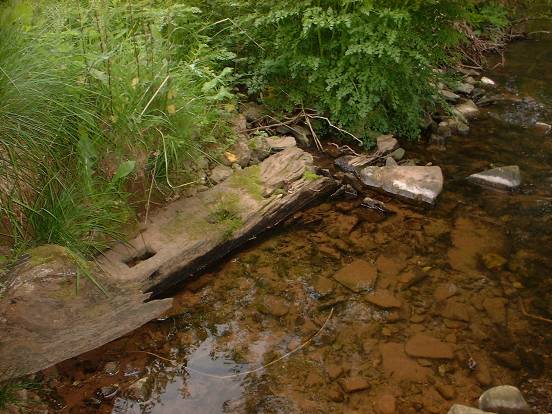
2.4.3 Slough Brook.
The remains of a wooden structure have been found along the Slough Brook up stream of the White House. This structure may well have been part of a catchwork water meadow system higher up the valley. Associated leates are visible on the valley sides. Dendro dating might help to provide dating of this structure.
Photograph 16. Wooden structure in the Slough Brook.
2.5 Earthwork Features within Fields
A Survey of ground features in the river valley fields at Turnastone Court Farm has been undertaken.
Elevations and Ground Features at Turnastone Court Farm
[Red highest, Blue lowest]

However the interpretation of the survey is not an easy task. There were probably water meadows features in each of the fields surveyed but time and other factors have made understanding these remnants difficult.
It is likely that there are underlying historical features in some of the fields. For example there may have been a mediaeval ‘three field system’ underlying Weeths Orles and Weeths Meadow that was adapted to allow irrigation. It also appears that there was a causeway across Weeths Meadow along the line of the footpath. In Hampshire River valleys there are numerous causeways across water meadows which were both tracks across the wet land for people to use and drove tracks to allow the movement of sheep and other animals to and from the water meadows daily. The Trench Royal also appears to use the line of an older feature running up the valley perhaps an old Roman road. So it appears that existing landscape features were adapted for farming and irrigation purposes during the time the land was irrigated .
Another factor making interpretation difficult is the relic watercourses across the fields. There is the obvious route of an old watercourse through Weeths Meadow. This is probably the route of the Slough Brook before it was diverted along its present channel to the west side of the field.
The valley is prone to high water flows with water levels rising and falling rapidly. The water would not always be contained within the banks of the river and brooks, causing erosion and deposition. These processes continue to occur. Some of the features picked up by the survey may be channels that have eroded since the irrigation stopped. Also the silt carried in the water has been deposited on the meadows especially in low places as floodwater recedes.
Factors affecting the interpretation of the old water meadow fields at Turnastone Court Farm include:
· The fields of Turnastone Court Farm have been used by man and the ground surface changed by agriculture and other land use long before 1600.
· In the sixteenth century it is likely that existing surface features were modified to facilitate an irrigation scheme.
· The nature of the brooks and river, given to ‘flash floods’, has washed away parts of the old sluices and eroded the land form over the meadows. It is likely there were additional structures to those seen today that have been completely eroded away. These may have been washed away, decayed if they were wooden, or ‘robbed out’ if they were stone. No wooden structures have been found within the fields at Turnastone Court Farm but the remains of wooden structures have been seen upstream in the Slough Brook.
· Deposition of silt has also occurred over the past 400 years (and longer) so low areas have become ‘filled in’ so are not as deep as in the past, and not as clearly identified. Vaughan writes about the problems of silt deposition in the Trench Royal, stating that 2-foot depth of silt needed removing after 4 years.
· Intervention by man is also a major factor. These fields are near the farm; they have been intensively used for livestock.
· The water has been deliberately prevented from flowing along the Trench Royal through Turnastone Court Farm by bunding and stone filling the Trench Royal at point A. Willows have been planted along its route in Ross’s Meadow. The Trench Royal has been piped under the road through the village.
· Hedges were planted in the nineteenth century this may have been along the lines of old ditches, but in Ross’s meadow it changed the line of the western boundary. So other field shapes and extents may also have been changed.
The nature of the landscape on Turnastone Court Farm to the north of the road is very different to that on the south side of the road.
To the north there is a small intimate landscape of small fields and thorn hedges planted in the early part of the nineteenth century. The irrigation in these fields must have fallen out of use before new hedgerows were planted that changed the shape of the fields. To understand how the irrigation in these fields worked a view should be taken of Poston Court Farm, to the north. On Poston Court Farm the fields are large and open with few hedges in a pattern that is likely to be similar in size and shape to the late eighteenth century landscape.
West of the Trench Royal on the side of the valley there is an earthwork feature running along the contour. This feature may have continued across Turnastone land and is likely to have been created before Vaughan’s time, but it is probable that it was used as a carrier for water. A catchwork system of irrigation would have been in operation across Ross’ Meadow with the water draining to the Trench Royal.
On Poston Court land to the east of the Trench Royal there were sluices at Poston Court Farm which fed a carrier running along side the Trench Royal and irrigated the fields towards the river. A similar system may have operated in fields on Turnastone land south of the Shegear Brook. The sluice arrangement has been changed considerably but it is likely that in the past it was constructed on a similar layout to that where the Trenant Brook joins the Trench Royal higher up the valley [see photograph 14]. The sluice would have set so that most of the water would flow along the Trench Royal. There would be an overflow to allow water to run back to the river as it does today and there would be an arrangement whereby water could be directed along a carrier in Ox Lease adjacent and parallel to the Trench Royal. No remains of this carrier can be seen today. Ox Lease and Turnastone meadow would have been irrigated as catchwork meadows with the water-running west to east towards the river Dore. There is the remains of a sluice in the Shegear Brook between the Trench Royal and the river Dore (point D), so the catchworks are likely to have incorporated two carriers one (as described above) along side the Trench Royal. The second, following the line of hedge 5, collected water from Ox Lease and irrigated the field below, Turnastone Meadow. The earth bank running through this field north- south is likely to be of older origin than the irrigation system but would be used as part of the irrigation to form a catchwork system. The herring bone drainage channels seen in this field may have been an integral part of the irrigation to drain water away. However Vaughan does not talk about drainage and this may have been a later excavation to aid the drainage of the field at times of natural flooding.
Unless documentary evidence from estate records can be found it is unlikely that it will ever be known when the flow along the Trench Royal was stopped (at point D). Water still does flow along the section of the Trench Royal through Turnastone Court Farm at times of flood and it is likely the trees were planted in the Trench Royal during the twentieth century, to stop or slow flows along the Trench Royal and reduce flooding in the village. Investigation of fields at Poston Court Farm would help our understanding of the past management of these fields.
The irrigation system on Turnastone Farm to the north of the village has been almost obliterated by ploughing - likely to have been carried out at the beginning of the nineteenth century when the price of corn (for both human and cattle consumption) was high – and by the planting of hedges. It is also likely some fields would also have been ploughed during the First World War. It is known that the Watkins family were prominent members of the farming community and ploughing matches were held at Turnastone Court Farm.
To the south of the road the landscape is more open and although hedges have been planted round Weeths Meadow and Long Field probably in the early nineteenth century the shape of the fields remained unchanged.
Long Meadow is the lower end of an extensive system that ran down the Slough Valley. It was irrigated from the Slough Brook via Sluice C. Water was directed on to the field by sluice C and also a short distance lower down the field. Springs from across the road to the north may also have added to the irrigation of this field in the past. Water would have been channelled along the two banks running down this field and allowed to settle on the lower parts of the field. The shallow cuts, at right angles to the banks, would have been to aid the even distribution of water and silt. There are no obvious drainage channels in this field. So any water directed to this field would stagnate and slowing sink into the ground, hence Vaughan’s comment that he only ‘turned’ the water on for short periods at a time. The aims were two fold; firstly to fertilise the land by means of ‘muddy floods’ (silt laden nutrient rich water) directed to the fields and allowed to settle there, and secondly to irrigate in the summer to enhance the grass growth (and hay crop) so valuable for the livestock farmer.
The earth works parallel to the road by the village are more likely to be associated with the village than the irrigation of the field.
Weeths meadow was irrigated along similar lines. The sluices at point B and C directed water along carriers to different areas (basins), where the water settled. This is a more complex system to that in Long Meadow with side carriers to ensure the whole of the meadow was evenly flooded. Structures with the field have been robbed out or destroyed. It is also likely that the channels have been adapted and changed over time. The footpath follows a causeway from point A to J across this meadow. Whether this causeway was constructed before the irrigation system or as part of the irrigation system is difficult to say.
This field is a hybrid system of the original intention and post construction adaptations to help the water flow. Further investigation of neighbouring fields to the south of Weeths Meadows and up the valley to the west of Long Field would help our understanding of how these fields operated.
The canal discussed in Vaughan’s Book is said to have run though Weeths Orle to his ‘port’ just below the White House. There is evidence of a channel along the north side of this field. The slope on this field makes it unlikely that the canal to the White House was in operation for any length of time.
There was a catchworks system in Weeths Orle. Water from the brook at point M and the springs in this field would make it a very valuable hay meadow. The catchwork channels directed water along the contours parallel to the wood. Water could then flow over the ground down towards the ‘canal’, which would act as a drain to the Slough Brook at sluice A.
The function of the Trench Royal north of Turnastone may have been to aid water supply to irrigation fields. On Turnastone land between the Trench Royal and the River Dore the Trench Royal supplied the water for irrigation. However, within Turnastone Court Farm, to the west of the Trench Royal, the water supply came from the Shegear and Slough Brooks with the Trench Royal acting as a drain.
This study has been conducted between January and July 2004. The limited time available and the limitations of the remit (within Turnastone Court Farm land) for this study have made definitive answers on the water meadows and how they worked difficult. The meadows need to be viewed at different times of year and different weather conditions to help aid the understanding of their operation, when slight features within the meadows can be seen under differing conditions of light and vegetation growth. The water meadows at Turnastone Court Farm are part of a large complex system of irrigation running the length of the Dore Valley and its tributaries and should be viewed as part of that large system.
Further investigation is needed to fully interpret these features to help understand the sequence of events that created the field topography we see today. Man and natural events have intertwined in a complex relationship over the past centuries.
2.6 RECOMMENDATIONS FOR FUTURE MANAGEMENT OF THE WATER MEADOW SYSTEM
The majority of the system has become derelict. It would take a great deal of time and effort to reinstate the whole of the water meadow system at Turnastone, and would necessitate the co-operation of neighbours. This would not be economically sustainable or historically recommended.
The majority of the fields should remain in grassland. To preserve the historic integrity of the remnants, there should be no ploughing or earthmoving. The grassland should be managed with grazing and/ or hay cropping. There should be no new tree or hedge planting except along the line of existing hedgerows.
Stabilisation of structures
There is the immediate requirement to stabilise some parts of structures to prevent further degradation by
· tree roots damaging stone work and foundations.
· erosion or undermining of structures by water
All the structures need some work of this nature.
Trees and shrubs growing very close to or on structures need to be assessed and dealt with on an individual basis with relevant ecological and arboricultural advice. In some circumstance the careful removal of a tree which is causing damage to an otherwise sound structure will cause little impact to the landscape or ecological quality of the site. Trees or shrubs should be cut back to as close to the structure as possible and the root system left to decay in situ. Physical removal will usually result in structural damage. The work is best carried out in the autumn or winter. In certain circumstances it may be necessary to treat the stump with a suitable biocide to accelerate the process. Chemical control is best avoided if possible, but in all cases any use of chemicals must take into account safety and potential pollution of the watercourse. Defra and the Environment Agency should be consulted abut the use of chemicals near water courses.
The stabilisation of the bed of the watercourse through the structures is important to prevent undermining of walls and complete collapse of part of the sluices. The work is best done during the summer at times of low flow. It will be necessary, in places, to temporarily dam sections of the brooks to allow access to undertake repairs. Advice from the Environment Agency should be sought at an early stage on the need for licences for works within river because of the possible impact on the ecology and hydrology of the river system. The River Monnow project will also need to be consulted about the ecological implications for the river environment.
Ideally the base of the brook should be cobbled with local stone in the same manner as seen by some of the structures. However cost, limitation on time and skills needed, and the urgency of the work may make this a nonviable option. Some sluices have in the past been repaired with concrete so this may be an acceptable option.
Longer term objectives for structures.
The aim should be as little intervention as possible with an existing historic structure. Unfortunately in a river environment this is not usually possible.
Conservation of the structures should be the minimum necessary to consolidate the structure. It is important not to ’over restore’ these historic structures as their origins are likely to be as early as 1590. Restoration work in different building styles, sizes of stone work and brick all leave a testament to the people living and working at Turnastone over the past 400 years.
Cracks and missing stone are not a problem unless there is danger of collapse or they are causing water to be trapped where it is likely to accelerate decay. Materials used should be compatible with the existing stone and brick work. Mortars should be lime based and weaker than the stone and masonry. Use of hard cement based mortars should be avoided since they may result in accelerated decay of surrounding material.
Structures of stone in damp conditions will naturally attract moss and lichen growth and a thin covering of soil. Their presence is not likely to cause damage and may be important ecologically and should not be removed. If the riverbank is regularly grazed then this is the most appropriate method of control of vegetation. However if the animals are excluded from the riverbank excessive vegetation should be cut back to prevent the structure becoming over grown and obscured.
Restoration of irrigation
There are two fields were it may be possible to reinstate part of the irrigation system; Weeths Meadow and Lower Cross Field.
Weeths Meadow - field 6717. See Appendix C
Sluice A on the Slough Brook is in fairly good repair and could be used to flood water over the lower half of the field. This would need careful operation as the Slough Brook is very ‘spatey’ with water levels and flows rising and falling rapidly. If boards were placed in the sluice then the water meadow system could be operated in the winter to provide a wet grassland habitat for over wintering birds and breeding waders. Work is needed to prevent water undermining the sill and additional work will be required to raise the height of the adjacent concrete wall.
Restoration of irrigation in this field is subject to effective repair of the main sluice.
This would achieve several objectives
· It could be used to demonstrate how the water meadows worked
· Provide wetland habitat for over wintering birds
· Provide wet grassland as a feeding area for breeding birds.
· Help to provide a reliable hay crop as it did historically
This course of action is not recommend to be under taken in the first half of the Countryside Stewardship Agreement to allow the new farming business time to develop and become sustainable before additional projects are under taken .
However decisions need to be made by Countryside Restoration Trust about their long term policy in this area. The layout and structures of old water meadows can be conserved in many ways. That does not necessarily mean they return to functional irrigated systems. If Countryside Restoration Trust thinks they wish to reintroduce irrigation and pursue this option then further investigation will be needed to determine:
· The amount of water needed to irrigate this meadow
· Timing of water extraction and effect on water flows in the Slough Brook
· The area that will be effected
· Erosion risks to the structures and land form.
· Where water will drain to and if it will effect neighbours
· Areas and rates of deposition of silt on the meadows
· If any of the above will effect underlying archaeology
· The effect on the ecology and hydrology of the river system
If this proposal for restoration of irrigation is agreed then a schedule of irrigation and grazing will need to be drawn up. This should include:
· Consideration of the effect on the sward of reintroduction of irrigation.
· Irrigation - duration and timing of the turns through out the year .
· Grazing regime - stocking density and types of animals needed to achieve to conservation objectives.
· Viability of hay cropping
· Program of ongoing maintenance work (which is likely to incur significant costs)
Advice and consents should be sought from;
· The River Monnow Project (re fish habitat and migration patterns)
· The Environment Agency; abstraction licences and land drainage consents will be necessary if this option is to be pursued.
· The Hereford County Archaeologist Keith Ray should also be consulted before an work to irrigate land so he is satisfied it does not compromise archaeological remains.
· The Local Council Public Right of Way Officer as to the effect this work make have on the footpath
· The neighbouring farm would need to be consulted and informed of any work to reintroduce irrigation to this field
Ross Meadow (Lower Cross Field) - field 2781.
The ditch along the northern boundary of this field is spring fed via the Shegear Brook. The ditch only flows during the winter and at times of heavy rainfall. So, if restoration of irrigation is proposed for this field then the operation of the system would be weather dependant, depending on the water flows from the spring, and likely to be winter irrigation only.
This would achieve several objectives:
· It could be used to demonstrate how the water meadows worked
· Provide wetland habitat for over wintering birds
· Provide wet grassland as a feeding area for breeding birds.
· Provide a reliable hay crop as it did historically
However decisions need to be made by Countryside Restoration Trust about their long term policy in this area. If CRT think they wish to pursue this option then further investigation will be needed to determine:
· The amount of water needed to irrigate this meadow and possible effect on the ecology and hydrology of the river system
· Timing of water extraction and effect on water flows in the Trenant Brook
· The area that will be effected
· Erosion risks to the land form.
· Where water will drain to and if it will effect neighbours
· Areas and rates of deposition of silt on the meadows
· If any of the above will effect underlying archaeology
If this proposal for restoration of irrigation is agreed then a schedule of irrigation and grazing will need to be drawn up specifically for this meadow. This should include:
· Consideration of the effect on the sward of reintroduction of irrigation.
· Irrigation - duration and timing of the turns through out the year.
· Grazing regime - stocking density and types of animals needed to achieve to conservation objectives.
· Viability of hay cropping
· Program of ongoing maintenance work (which is likely to incur significant costs)
Advice and consents should be sought from;
· The River Monnow Project (re fish habitat and migration patterns)
· The Environment Agency; abstraction licences and land drainage consents may be necessary if this option is to be pursued.
· The Hereford County Archaeologist Keith Ray should also be consulted before an work to irrigate land so he is satisfied it does not compromise underlying archaeological remains.
· The Local Council Public Right of Way Officer as to the effect this work make have on the bridle way.
· The neighbouring farm would need to be consulted and informed of any work to reintroduce irrigation to this field
Work needed would include
· Coppicing the hedge along the northern boundary to reduce it height and width.
· Ditch Restoration
· Two new sluices put in to control the water flow
· Foot bridges, gates and stiles when water flows would drain across the public right of way.
· Interpretation boards explaining the historical and ecological significance of the field.
Irrigation of water meadows is not an exact science. Skills and experience of the restoration and operation of water meadows are scarce. There are only about half a dozen ‘drowners’ in the country, so restoration of these systems would have to be viewed as an experiment. The weather and rivers flows will have a dramatic effect on the success of any restoration project and are not predictable. Hence careful consideration needs to be taken before embarking on even the initial stages of a project for reintroduction of irrigation. However, even if no work is started immediately research is on going into different elements of water meadows such as hydrology, ecology, history, nutrient balance, sward composition at Imperial College and Norwich City College, so a delay in initiating work on this may be advisable.
Turnastone Court Farm is only a small part of Rowland Vaughan’s Water Works. Water meadow systems are extensive along the Golden Valley so Turnastone Court farm should not be viewed in isolation, but as part of a whole catchment system with each section interdependent on neighbouring systems.
3.0 ECOLOGY
Recommendations for the future management of the old water meadows at Turnastone Court Farm cannot be made solely in a historical context, or if dramatic changes such as the reintroduction of irrigation as an independent unit are forthcoming. In the past, unbalanced actions have led to destruction of both existing ecological interest and historical features. The study by Stearne (2004) has identified over 32 issues, which should be considered before changes in management practice can be implemented. A balanced integrated approach is needed to prevent misunderstanding and degradation of both historical and ecological features on this or neighbouring farms through ignorance.
3.1 BOTANICAL INTEREST
The water meadow fields have little diversity, mainly grasses with few herbs (with the exception of Field no 6714). This could be a legacy of the irrigation system, which favoured grasses especially agrostis at the expense of all other grasses and herbs. But it may be that some of the fields were improved or fertilised in the past. The hedge bottoms have some botanical interest.
3.2 B IRDS
Birds can be indicators of the ecological health of an area. There are many different species of bird at Turnastone, song thrush, blackbirds, robins, tree sparrows etc. are seen as common, though the UK populations of song thrush and tree sparrows has declined by 59% and 95% respectively between 1970 and 1998[2] . Other birds are declining and the following examples are given to highlight their particular management requirements. Curlews have been seen in fields at Turnastone Court. They nest in areas of tall grassy vegetation, such as hay meadows or tussocks in grazed pasture, and feed on soil invertebrates in damp grassland. Lapwing and breeding waders’ numbers have declined in recent years but could be encouraged with sympathetic grassland management. Lapwings nest on spring tillage or short tussock grassland, ideally in open areas away from hedges and trees. They feed on soil invertebrates especially in wet areas in grazed fields. Barn owls nest in farm buildings and large holes in trees and feed on small mammals in rough grassland. Leaving an uncut margin round hay fields encourages small mammals and provides a corridor for hunting owls. Skylarks nest in open areas such as hay or spring cereals. They use the middle of large fields away from hedges or trees. See draft grassland management plan appendix A
3.3 M AMMALS
Both otter and water vole populations have declined drastically in the twentieth century mainly due to habitat degradation and water pollution. Both are protected under the Wildlife and Countryside Act 1981.
Otters favour all wetlands from rivers, lakes and streams to marshes and reed beds. Individuals have large home ranges, which may contain up to 30 lying up places or holts usually in the form of natural hollows in tree roots or amongst dense vegetation. Otters have recently been seen in the valley. The numerous well used footpaths and open nature of the land near the river would discourage the otters. However careful siting of two timber construction otter holts may encourage these shy animals.
Water voles are found on rivers and almost any kind of waterway. Continuous dense luxuriant vegetation grasses and sedges, provide water vole colonies with potential refuge, cover and food. Water voles may be present on adjacent farms but were not noticed at Turnastone Court. Buffer strips, up to 6m of uncut vegetation, along side the water courses have high conservation value for both otters and water voles.
Apart from the stabilisation and restoration of structures within the farm boundary, no work is planned as part of this report to the River Dore or Slough Brook. The River Monnow Project is carrying out an extensive program of management of bankside vegetation and trees along with erosion protection measure for the river banks. They are concerned with the enhancement of the river environment.
If work is proposed to the river and brooks in the future then a detailed survey for water voles would need to be carried out before any work is started to ensure their habitat is not disturbed. (Wildlife and Countryside Act 1981). It is recommended that some form of simple monitoring takes place to assess if otters, water voles or mink are present on the farm.
Bats, like birds, are barometers of the health of the countryside. Waterside meadows are important areas for bats to feed and the large old trees on the farm will provide roosting areas. Recent studies with electronic bat detectors have shown that numbers of feeding bats can be extremely high in well managed river valley flood plains. River valleys provide sheltered areas where flying insects congregate in pockets of warm still air. Bat feeding activity over rivers and ponds is often at its most intensive where bankside trees and shrubs occurs, as they harbour large volumes of flying insects and provide protection from predators. Un-shaded areas of open water are also important to wildlife and insect life cycles. So a balance needs to be maintained between open and shaded areas of water. When tree surgery is carried out provision of bat boxes in addition too existing roosts would encourage these mammals
3.4 HEDGROWS AND TREES
The pre 1830 landscape of the river valley was likely to be more open than today. The majority of the hedgerows are post 1840 enclosures as the field boundaries change position on the 1885 Maps. They are mainly mixed thorn and most have been laid at some time in the past. Good hedgerows will support an abundance of insects on the farm, provide habitat for a range of birds and mammals and provide a rich supply of food for some species throughout the year. The management of field margins abutting the hedge is critical for a wide range of species.
The aim of hedgerow management at Turnastone Court Farm should be a range of different heights and age structure, stock-proof hedges to support a variety of wildlife. However on the lower water meadow fields these hedges should be managed to reduce their height to a maximum of 1.25 m to allow a more open feel to the landscape and encourage ground nesting birds. Initially some of these hedges may be allowed to grow up to 2m prior to being laid.
The roadside hedges are mainly thick stock-proof hedges of mixed thorn but with yew in places.
A line of willows has been planted in field along the line of the Trench Royal which have been pollarded in the past.
4.0 ACCESS & EDUCATION
Several footpaths cross Turnastone Court Farm and a bridleway runs alongside the Trench Royal from Peterchurch to Chanston Farm. These cause problems with dogs running loose disturbing wildlife, so dog owners should be encouraged to keep dogs under control and on leads when crossing the property. To this end interpretation boards should be erected at three points where public rights of way enter the property. The boards should emphasis the ecological interest of the Dore Valley, encourage responsible use of the countryside and explain the historical importance of the riverside meadows.
When coppicing or other tree work is carried out along the River Dore or Shegear Brook, if the river banks are fenced then the fence should be sited 5 to 6 m out from the river bank and the footpath directed along the river side of the fence. This would prevent grazing animals causing damage to the river banks and allow a tussocky sward to establish that would be good habitat for mammals and invertebrates. The Public Right of Way (PRoW) could be kept to the river banks and the public (including dogs) prevented from crossing the middle of the fields where there may be ground nesting birds. It is advisable to site the fence a reasonable distance from the river bank to enable easy access to the river to manage the vegetation so scrub and woody material does not become established. The River Monnow Project should be consulted about the effect this may have on the ecology of the river channel. The County PRoW officer should be consulted about the fencing of the PRoW and the County Archaeologist about the siting of fence posts (to avoid damage to underlying archaeology).
Educational access should be encouraged. Ideally open days and visitors should not be encouraged in spring time and be arranged for after late July, summer autumn and winter, when ground nesting birds have finished breeding. This may not be possible for school parties as they like to arrange field trips for the summer term April to July, but visits January to March could be encouraged to look at over-wintering birds, the landscape of the valley and the farm animals.
5.0 Recommendations for future consideration.
5.1 Agriculture
The farm is managed in an ecologically and archeologically sympathetic way with extensive grazing and hay cropping, but with no inputs of artificial fertiliser and in line with Good Agricultural Practice as outlined in the Booklets - ‘Good Agricultural Practice for Soil; Air; Water and Ecology’.
Recommendations for field and hedgerow management of the water meadows are outlined in Appendix A & B below.
5.2 Ecology
There is a baseline of ecological data and this ecology should continue to be monitored in partnership with local organisations for example the River Monnow Project and Hereford Wildlife Trust with sharing of information. The farming operations may need adjustment with experience and changing weather patterns.
5.3 Archaeology
There is still much to discover about the past land use at Turnastone Court Farm and the Golden Valley.
It would be interesting to carry out archaeological excavation but these would need to be carefully sites and approval by Hereford County Archaeologists. A first exercise would be to carry out a geophysical survey of the line of the Trench Royal extending approximately 6 m either side of the existing ditch line. This would help to inform about possible sluice location, lining of the Trench Royal and possible causeways adjacent to the Trench Royal.
5.4 Access
One of the aims of the Countryside Restoration Trust is education, so access in the form of guided walks and open days is recommended at appropriate times of year, but avoiding the breeding season for birds.
5.5 Landscape
Turnastone Court Farm is a part of the jigsaw of the landscape of the Golden Valley and Welsh Borders. The farm needs to be viewed in the wider landscape to better understand it history ecology and landscape setting.
6.0 Significance of the Water Meadows at Turnastone Court Farm
6.1 Landscape Quality .
The Farm is of local importance for its landscape quality. It contains fine views with contrasting patterns of grassland and woodland management and the post enclosure hedgerow layout.
6.2 Time Depth and Historical and Archaeological Potential .
Turnastone Court Farm within the Golden Valley is of national significance for its depth and historical and archaeological potential. There is evidence of pre-Roman activity and there has been continuous use of the land for human occupation since at least the eleventh century. Features of this continuity include the use of the land for agriculture especially the water meadows dating back to the fifteenth century and documented by Rowland Vaughan. Structures show evidence of repair and restoration (implying irrigation of the water meadows) to the end of the nineteenth century and possibly the mid twentieth century. The book by Rowland Vaughan is the first significant text giving details of water meadows and the remains at Turnastone Court Farm follow the general layout and design described by that text. However, while the information in this plan clarifies some of the historical issues, there has been no in-depth examination of the pre-1600 archaeological potential. The farm is thus of regional significance for the potential historical and archaeological information that it can offer.
6.3 Conservation History
The water meadows are of local importance for nature conservation, as it they have largely remained grassland for the majority of the twentieth century with adjacent fields and farm land ploughed regularly. These meadows are likely to be the least disturbed on the flood plain of the River Dore. Hence they are of ecological and historical interest
Appendix A - GRASSLAND MANAGEMENT PLAN
Long Meadow - field no. 4330 - 10.06 ha - Formerly a water meadow operating much as described by Rowland Vaughan in 1610. Little remains of the sluice at ‘C’ that controlled the water flow to this meadow, and there may have been a second structure in this field of which little remains apart from a few stones in the river. This meadow contains the remnants of the earthworks associated with the water meadows which should be protected. It could be managed as a hay meadow, but predominately pasture management would be a better option here with a reduced number of animals ( 0.6 lu/ha ) between 1 April and 15 July, to allow ground nesting birds to breed. Then an increased stocking rate could be adopted in the summer and autumn to graze the sward down.
Weeths Orles - field no. 4584 - 8.39 ha – A catchwork irrigation system would have operated in this field at some time in the past. It is a sloping hay meadow with an interesting diversity of flora. It should be left largely undisturbed in spring, the cattle removed by the end of March and the area shut up for hay two years in three, with a hay cut alternate years mid June and mid to late July to allow flowering herbs to seed. Aftermath grazing could be cattle or sheep.
The remnant earthworks are low so are not threatened by grass cutting machinery, but there are three or four blocks of ‘cornerstone’ and some ‘wet flushes’ at the top of the slope which makes hay making difficult and the flora along the edge of the wood where hay has not been cut is clearly different from the rest of the field. This top edge of the field needs either to be cut with the rest of the field (the stones and wet areas marked first so machinery is not damaged) or a temporary (electric) fence erected to allow the area to be grazed hard in spring (ground conditions allowing) without disturbing the rest of the field. The woodland overhangs and encroaches onto the field; intensive grazing of this area in successive springs should prevent further encroachment.
Access to this field is over the stone bridge, which is not suitable for tractors and trailers, and may collapse if crossed by vehicles and machinery. A new bridge is urgently needed.
Weeths meadow – field no. 6717 – 11.10 ha - - Formerly a water meadow operating much as described by Rowland Vaughan in 1610. Two sluices controlled the water supply to this meadow. The upstream sluice (B) has only one side left but the other sluice (A) is in fairly good repair. If this sluice (A) is restored and the banks re-sectioned then the water level in the river could be raised to allow the lower part of the field to flood. This would demonstrate how part of the original water system worked. If controlled flooding was practised in spring this would encourage wet grassland to develop, encouraging over-wintering birds and breeding waders. (This could attract an additional grant of £60 ha a year GW under the Countryside Stewardship Scheme). The Environment Agency should be consulted as a licence to ‘dam a stream’ and/or ‘abstract water’ may be necessary. The River Monnow Project should also be involved in discussions, along with the County Archaeologist.
Several paths cross in the area of sluice A so this would be a good point to put an interpretation board and bench so walkers and visitors could appreciate the uniqueness of this field and be reminded of the countryside code and need to control dogs. Hedges round this field need to be maintained as low as possible if breeding waders are to be encouraged.
Ross meadow (lower cross field) – field no. 2781 - 3.75ha. - Formerly a water meadow operating much as described by Rowland Vaughn in 1610. A spring fed stream runs along the line of the overgrown hedge on the northern side of the field. It would be possible to restore some of this field to an irrigated water meadow. The northern hedge (hedge 1) would need cutting back, the ditch along side needs restoring and two sluices would need to be constructed to control the flow of water. The water will drain to the Trench Royal in the south east corner and across the bridle way. This would demonstrate how part of the original water system worked. If controlled flooding were timed for winter and spring this would encourage wet grassland to develop encourage over wintering birds and breeding waders. (This could attract an additional grant of £225 ha a year Water meadow restoration - code P5 under the Countryside Stewardship Scheme). The County Archaeologist should be consulted and detailed diagrams drawn before any sluices are installed. . The River Monnow Project should also be involved in discussions.
A stile and footbridge to allow walkers to cross the out flow of irrigation water would be needed here. The Environment Agency should be consulted but it is unlikely they would have any objection as the water source is spring fed and this field is more than 8m away from the river.
Turnastone meadow – field no. 6282 – 6.05ha. - Formerly a water meadow operating much as described by Rowland Vaughan in 1610. There are the remains of a sluice at the north-west corner but very little remains. There are two footpaths crossing this field. Extensive grazing and hay cropping would be suitable management in this field. The public foot path enters the farm here from the caravan site across the river, so this would be a good place to site an interpretation board so walkers and visitors could appreciate the uniqueness of this field and be reminded of the countryside code and need to control dogs. As mentioned in section 4, if the river banks are fenced the fence should be sited 5 to 6 m out from the river bank and the footpath directed along the river side of the fence.
Ox leas – field no. 4978 –3.35ha. - Formerly a water meadow fed from the Trench Royal operating much as described by Rowland Vaughn in 1610. T here are some earthworks here but little is left. Extensive grazing and hay cropping would be suitable management in this field.
Tumpy Piece - field no. 6656 – 2.75 ha. This field never was a water meadow. However there are numerous earthworks in it. It is best left as pasture for grazing animals especially as it is close to the farm buildings.
Bridge Meadow - field no. 0346 – 0.89 ha. This long narrow field was probably once part of the water meadow system however the construction of the Golden Valley Railway has obliterated remnants of it. The remains of the bank that carried the track bed of the railway line are clearly visible crossing this field and in themselves are of historical interest. Details of the Golden Valley Railway are documented in the booklet The Golden Valley Railway by W. H. Smith (1993) with pictures and maps of Vowchurch Station (across the road from Bridge Meadow).
The field could be managed either as pasture of for hay, h elping to create wildlife corridors for hunting barn owls and bats.
There appear to be no water troughs in the fields at Turnastone Court Farm so the stock must walk down to /into the river and streams to drink. This practice may cause erosion of the banks and disturbance of the silt, adding to diffuse pollution and ‘smothering’ of gravel beds in the water courses. To prevent this some form of drinking trough needs to be installed for the animals. This could be the usual drinking trough and piped water supply (grant aid available as part of the CSS) or pasture pumps for which may be a more flexible system (but grant may need to be negotiated under CSS). Fencing is also seen as a solution to animals trampling and eroding river banks and this may be an option along the River Dore. The footpath could be kept to the river side reducing disturbance to stock and wildlife if the fencing were 3to 4 m out in the field (this will reduce the field size and the foot path will need maintenance / cutting). But I do not recommend fencing other water courses as this may create difficulties of controlling/ cutting banks side vegetation where animals are not allowed to graze
No Fertiliser or manure should be spread in fields where it is proposed to reintroduce irrigation, as this would be a possible source of river pollution.
APPENDIX B - HEDGROW RESTORATION PLAN
Road side hedges These are on the whole good thick mainly mixed thorn stock proof hedges. In place they contain. A small length (hedge 7) needs gapping up and fencing, in the area of the pond. Road side hedges should be cut on the road side each year but allowed to grow up to 1.5m height and cut on the field side every third or fourth year.
Hedge 1 - the Trench Royal Willows have been planted in the ditch along part of the length. These should be pollarded on rotation 4 a year for 3 years in autumn and then on a 5 year rotation. There are old coppiced Hazels along part of the length these need re coppicing in autumn 2006. There is a mixed thorn hedge along part of the length this should be coppiced, gapped up and fenced autumn 2005, with thought to laying it at a later date (2012).
Hedge 2 This is not stock proof and gappy in places. This is a post enclosure hedge, which changed the field shape in the nineteenth century. Pre 1800 there is unlikely to have been a hedge here. Although ecologically and historically this hedge should not be here it is unlikely that permission would be granted to remove it. It needs to be made stock proof to allow the field grazing to be well managed. It should be allowed to grow up for 3 years then laid in autumn 2008 at a low level of a maximum of 1.2 metre height. The hedge should then be managed by cutting on a bi-annual cycle to a maximum height of 1.5m; this will ensure that the open landscape is maintained and ground nesting birds are encouraged.
Hedge 3 - cut back and restore ditch alongside. Not owned by Turnastone Court Farm the neighbour’s permission is needed.
Hedge 4 is a thick thorn hedge and does not need restoration.
Hedge 5 and 6 – These are mixed thorn hedges with dog’s mercury growing in the hedge bottom. They need to be made stock proof to allow grazing to be well managed. They could be allowed to grow up into tall bushy hedges.
Hedge 7 is a short length of road-side hedge round a pond it needs gapping up and fencing.
Hedge 8 This is quite a tall mixed thorn hedge. It should be left uncut this year and laid in winter 2006 at a low level of a maximum of 1.2 metre height. The hedge should then be managed by cutting on a bi-annual cycle to a maximum height of 1.5m. This will ensure that the open landscape is maintained and ground nesting birds are encouraged.
Hedge 9 There are coppiced trees along the water course. These need re- coppicing winter 2005/2006. This work may be undertaken by the River Morrow Project.
Hedge 10 This is a mixed thorn hedge with some standard trees and gappy in places. It belongs to the neighbouring farm. If an agreement with the neighbour can be reached. It should be gapped up and left uncut laid in winter 2009 at a low level of a maximum of 1.2 metre height. The hedge should then be managed by cutting on a bi-annual cycle to a maximum height of 1.5m. This will ensure that the open landscape is maintained and ground nesting birds are encouraged.
Hedges 11 and 12 These are long mixed thorn hedges. They should be allowed to grow up and half of each should be laid in consecutive years, over a four year period 2005 to 2008. They should be laid at a low level of a maximum of 1.2 metre height. The hedge should then be managed by cutting on a bi-annual cycle to a maximum height of 1.5m. this will ensure that the open landscape is maintained and ground nesting birds are encouraged.
Hedge 13 This is a mixed thorn hedge. It should be left uncut laid in winter 2009 at a low level of a maximum of 1.2 metre height. The hedge should then be managed by cutting on a bi-annual cycle to a maximum height of 1.5m. This will allow more light to the water course, ensure that the open landscape is maintained and ground nesting birds are encouraged.
Appendix C - Outline Specification for the restoration of irrigation in Weeths Meadow
For Countryside Restoration Trust to pursue the proposal to reintroduce water meadow irrigation at Turnastone Court Farm the following management plan is put forward as a guideline to the work required to set up the system and management of the meadows that would be advisable.
A balance of interests must be integrated to achieve a viable working system that can be considered the best way forward. Restoration to irrigation management – in certain circumstances it may be justifiable to restore the topography and structures to a fully operational system. The costs involved with this are high and work needs to be carefully planned. If the water meadow layout is amended for ecological purposes items of archaeological significance may be lost.
Neighbours upstream and downstream along the water courses should be kept fully informed of all work and intentions
Program of restoration work needed to allow the lower southern part of Weeths Meadow to be irrigated:
Restoration of Sluice A including;
· repair of sills and bed of the brook
· increasing the height of the concrete wall on the opposite bank.
· provision of new sliding board for the sluice and mechanism for changing their height. EA and River Monnow project would need consulting over design details for these boards and mechanism. Field investigations have not found any existing hatch mechanisms on Turnastone Court Farm. It is unlikely that they would have been constructed of metal as in Hampshire or remains would be found, so they were probably made of wood. There may be old sluices with control mechanisms to be seen in other river valleys in Hereford and these should be copied if possible. An overshot system is likely to be cheapest but difficult to operate and maintain. Also it is not favoured on ecological grounds for fish passage up stream. An undershot system would need careful design and agreement from the EA for installation.
Restoration of irrigation gutter along the line a – b
· The north side of this channel may need building up to prevent water flowing over parts of the field not intended for irrigation.
· The gutter should be cut as shallow as possible It will start reasonably wide (300mm) and deep (200mm) at sluice A tapering to less than 300mm deep and 150 mm wide at point b
· Provision of four small hatches along this channel
Restoration of the ditch along the south side of Weeths Meadow.
· The neighbours need consulting about this as it will affect their land (in arable cultivation). The whole meadow drains to the south east corner and the Trench Royal point K.
· The lower section of the Trench Royal (points J- K) though neighbouring land needs clearing to allow water to drain away without inconveniencing the neighbours down stream.
· Re-sectioning of shallow ditches along the lines identified in the survey to allow water to drain away.
Operation
The system (once necessary licences from the Environment Agency (EA) and County Archaeologist approval has been gained) could be filled with water by closing the new hatches. The initial filling of the system should only be carried out at times of high flows in the Slough Brook and with the approval of the River Monnow Project to ensure the closed hatches do not interfere with fish migration patterns. The forming of the subtle level changes need along the gutter to ensure even irrigation is carried out by hand. An initial length of no more than 30 m should be ‘stopped’ (with a temporary obstruction in the gutter) and both sides of the gutter adjusted with turf (supplied from off the meadow) to the required level.
This will require skill, time and, effort to get the water flowing correctly. To start with in December each compartment should be irrigated for a day at a time until the water flows within the meadow becomes known by the operator (or drowner). It should for the first two years at least be seen as an experimental system. Once the water is flowing evenly along the whole length of the gutter, the irrigation of different sections on rotation can be operated. Continual adjustment of the side of the gutter is necessary through out the year (the position of Drowner was a full time post) as water will erode the sides and animals will trample its edges. October and November was the time most of the maintenance work was carried out when other farm workers would be sent to the water meadows to help repair sluices, clear gutters and drains and level out eroded areas under the direction of the drowner.
Water could run along gutter and be directed to three or four individual compartments. The water flow and irrigation or drowning of the meadows needs to be changed and adjusted so in rotation all the areas to be irrigated are wetted on a six weekly cycle during cold weather in winter and a daily cycle if irrigation is practised in the summer. The table below is suggested as a guideline for the management of the land
Duration and timing of irrigation cycles would need to be agreed with the Environment Agency as abstraction licences would need to be applied for and obtained before any of this work commences. Neighbours should also be informed and consulted about irrigation timing.
Guidelines for annual management of Weeths Meadow if full restoration of water meadows is pursued.
| Date | Management | Objectives |
| January and February | Rotationally irrigate and drain on a cycle, l/2 weeks irrigation -2 /3 weeks drain, rotated round different sections of the field the fields. If only one section is irrigated at a time this will reduce the water abstracted from the brook. Consents - needed from EA for abstraction from Slough Brook | Historically practised management. To provide feeding areas for over-wintering birds. This is weather dependent, the colder the weather the longer the water can be left flowing. However, if the water is left flowing too long (over a month) then grass-kill may occur and this should be avoided. |
| March / April / mid May | Rotationally irrigate and drain sections of the field on a cycle of a week on - two week off - graze for one week. Graze with sheep or young stock during the day, ground conditions permitting. Temporary fencing will be necessary to move round the field and prevent animals poaching wet areas. Animals should not remain on the meadows at night. Keep livestock density below 0.6lu / ha.
Animal welfare - animals may be susceptible to foot rot and liver fluke, but the use of ivermectins would reduce the value of the dung. | Historically practised management. To graze the lush grass sward the winter irrigating has produced. Previously shepherd or a boy would spend the whole day with the sheep watching to ensure they did not stray it areas being irrigated.
Ecological gain. - Rotational irrigation will keep the ground soft as feeding areas for over wintering birds and feeding areas for breeding waders for example redshank. Grazing keep the grass sward low but with reduced numbers to allow ground nesting birds to flourish. The presence of livestock will help to enhance the invertebrate population. |
| Mid may remove | Remove animals Carry out maintenance to channels and drains | Historically practised management. Grazing for animals would have been available else where on the farm. |
| June | Rotationally irrigate and drain sections of the field on a cycle of maximum one to two days of irrigation* Length of irrigation depending on weather conditions, temperature and water flows | Historically practised management. To enhance hay crop.
Ecological gain. - Rotational irrigation will keep the ground soft as feeding areas and feeding areas for breeding waders |
| End of June | Drain |
|
| Mid end of July * | Hay crop | Historically practised management.
Ecological gain. - The hay crop to be cut after the 17 July to allow the birds to fledge and flowers to set seed. |
| August, September, October | Graze with cattle # | Traditional management
|
| November
December
| Maintenance work on structures, irrigation and drainage channels | Historically practised management would have been all hand labour, however some modern machinery is now available for used. |
* The cycles of irrigation, drainage and hay-cropping may be omitted in May, June and July.
# If sheep are grazed in the autumn care must be taken to avoid liver fluke e.g. use a different flock to that used in the spring.
Appendix D Draft Capital works plan
Appendix E Special Projects
[not available]
APPENDIX F – Glossary
Bedwork (system ) the ridge and furrow in the river valleys that allowed relatively flat areas to be floated. Water flows along tapering channels and discharges through the grass on the sides of the ridges ‘panes’ to flow away down the furrows and drains. The Britford Meadows south of Salisbury are good examples of bedworks systems.
Boards pieces of wood, usually elm, but could be oak, placed in the sluices or hatches to control the water flow.
Braving Trench followed the course of the river about 5 ft from the river bank (2 ft wide 1ft deep) – probably not within Turnastone Court Farm.
Carrier channel or groove in which water flows from the river to the meadow. The channel that carried water from the drowning carriage to irrigate the meadows, e.g. a main carrier, see also ‘header main’ .
Catchwork Meadows constructed on hillside dependent on gravity for rapid movement of water downhill, which made water meadows cheaper and easier to build. Mainly in the west of England, Wales and Perthshire.
Counter trenches carriers, run from the Trench Royal to carry water to individual fields.
Commanding weir The weir at Peterchurch that directed water to the Trench Royal
Drowner, or Mead Man men employed to look after, control and maintain the water meadows. They were well respected members of the community and the skill/trade would often pass down through the family. They made a mystery and art out of their work (Bettey 1999).
Everlasting Trench the outlet from the Trench Royal
Flat bottomed land. Land probably between the Slough Brook and the Trench Royal fields Weeths meadow and Long field at Turnastone Court Farm.
Floated up system hatches were installed at the lower end of the meadow and closed to form a dam. Water backed up the meadows. An early example of these may have been at Amesbury on the Upper Avon.
Flood Meadow a low lying area next to a water course that floods during heavy rainfall, or when water levels are high, usually during the winter. As distinguished from a true water meadows that is deliberately irrigated and drained to facilitate grass growth.
Goutes indentations in the bank to allow the water to flow over the land
Lists small embankments
Liver Fluke (Fasciola Hepatica) the larval stage of the fresh water snail, which invades a secondary host, the sheep’s liver, to the sheep’s detriment.
Moldy-Warp (also Wants) country name for a mole (Vaughan 1610).
Sheep -corn System an agricultural system where sheep and barley (or wheat) production were interdependent. Sheep were grazed on good grass during the day, then walked to the barley fields for the night, where their dung and urine fertilised the fields.
Sheep wash sheep were washed about a week or fortnight before shearing, a ‘sheep wash’ was a place where the sheep were made to swim though the water. It may just have been a part of the river fenced off with hurdles or it may have been a more permanent structure.
Sluice / Sluice gate sliding gate in a water channel for adjusting outflow or inflow of water to the channel. A dam with a series of wooden boards that water flowed over. One or more of the boards could be taken out to adjust the flow of water.
Soft- engineering in a river or water course this is the opposite of hard protection normally employing natural materials, for example log/ brush revetments, willow stakes and living vegetation. Hard engineering is a collective term for bank protection with materials such as steel, concrete and brick.
Stanke - a bank of dam. The Stanke Royal a 7 ft high dam probably situated at the lower end of the system where the trench royal meets the Slough brook near Chanston Farm.
Trench Royal the main carrier for water down the valley runs parallel to the River Dore (to maintain the higher level of water needed for irrigation further down the valley) about 16ft wide and 8 ft deep at the top end- 10ft wide 4 ft deep for the remainder. It falls about 40 feet along its length. At its lower end the Trench Royal also acted as a drain for the land irrigated from the Slough Brook
Turn the interval that the meadow is floated for. The water may be ‘turned’ onto the meadow for any time from a few hours to a few weeks. The period of time, allotted by regulation, during which hatches may be set for floating.
Wants see Moldy-Warp. Country name for a mole (Vaughan 1610).
The War Ag. The War Agricultural Committee that had powers during the Second World War to enforce farmers to plough up grassland in an effort to produce more home grown food when imports were blockaded by the enemy.
Water Gate a structure across a water course that allows water to flow freely, but prevents animals moving up or down stream.
Water Meadow an intensively managed area (usually in a valley) that uses controlled flooding to promote early grass growth.
BIBLIOGRAPHY
Atwood, G. 1964. A Study of Wiltshire Water Meadows, The Wiltshire
Archaeological and Natural History Magazine , vol. 58, pp. 403-413
Bettey, J.H. 1999. Development of Water Meadows in the Southern Counties. In Water Management in the English Landscapes , eds. Cook, H., and Williamson, T., pp. 179-195. Edinburgh University, Edinburgh
Bletchley L. 1982
Blith, W. 1653. The English Improver, John Wright, London
Bowles, N. 1988. The Southern Wey . River Wey Trust, Liphook
Bowie, G. G. S. 1987a. New sheep for old - changes in sheep farming in Hampshire 1792 – 1879. Agriculture History Review , vol. 35 , pt. 1, pp. 15-23
Bowie, G. G. S. 1987b. Water meadows in Wessex -- a re-evaluation for the period 1640-1850. Agricultural History Review , vol. 35 , pt. 2, pp. 151-158
Brown, G. 2002. Earthworks at Buildwas Abbey Shropshire English Heritage Archaeological Investigation Report Series AI/9/2002. NMR Nos.: SJ60SE 31,40,41. NGR: SJ642 004 ISSN 1478-7008
Clark J. 1794. General view of Agriculture in the County of Hereford. London.
Cook, Stearne & Williamson 2003. The origins of water meadows in England The Agricultural History Review vol. 51 . part II p.155-161
Cook H. and Williamson T., (Ed) 1999. Water Management in the English Landscape Edinburgh University Press. ISBN 1-85331-206-1
Delorme, M. 1989. A watery paradise. History Today , vol. 39, pp. 38-43
Duncumb J. 1805 General View of the County of Hereford. Bulmer and Co. London. p. 108-115
Fitzherbert, 1523. The boke of surveying and improvements p. 42-3
Hampshire County Council, 2000. Hampshire Water Meadows Survey in 3 volumes
Available from HCC Winchester
Hampshire County Council, 2004. The Conservation of Water Meadow Structures
Available from HCC Winchester
J.S. Kerr J. S. 2000 The Conservation Plan: a Guide to the preparation of Conservation Plans for Places of European Cultural Significance. 5th Edition
Kerridge, E. 1954a. Sheepfold in Wiltshire and the Floating of the Water Meadows. The Economic History Review , vol. VI , pp. 282-289
Kerridge, E. 1954b. Floating the Wiltshire Water Meadows. Wiltshire Archaeology and Natural History Magazine , vol. LV , December 1954
Palmer 1972. Soils in Hereforeshire III Sheet OS34 Soil Survey
Moorhouse, S.A. 1981. The Rural Medieval Landscape. West Yorkshire: an archaeological survey to AD1500, vol. 3 . West Yorkshire Metropolitan County Council, Wakefield.
Newson, M. 1992. Land, Water and Development, Routledge, London
Jones E. L. 1961. Agricultural Conditions and changes in Herefordshire 1660 – 1815
Transactions of the Woolhope Naturalist Field Club vol. XXXVII.
Jones J. Morgan J. and Morgan E. 1990. Dorstone 1890 –1990 A Centenary Celebration Dorstone Village History Committee 1990.
Seebohm, M.E. 1927. The Evolution of the English Farm . George Allen & Unwin, London
Smith W. H. 1993. The Golden Valley Railway Wild Swan Publications Ltd Didcot Oxon ISBN 1-874103 16X
Stearne K. Cook H. and Stearne P., 2002. Water meadows in southern England. Landwards
Institute of Agricultural Engineers Journal vol. 57 no.5
Stearne K. I. 2004. Water meadows in the English Landscape – conflict compromise and change PhD Thesis Imperial College London.
Turner
Vaughan 1610. Most approved and long experienced water works. London.
Weston, R. 1650. A Discourse of Husbandrie used in Brabant and Flanders; shewing the wonderfull improvement of land there; and serving as a pattern for our practice in this Commonwealth, William Du-Gard, London
Wood E. B. (ed.) 1897. reprint of Vaughan’s Book - Most approved and long experienced water works. in Rowland Vaughan: His Booke . Edited and introduction by Wood, E.B., John Hodges, London.
Wood A. S. 1954. A short history of Whitehouse and its owners, Vowchurch (pamphlet available in Hereford Records Office).
Wright T. 1779 The Art of Floating Land as Practised in the County of Gloucester, Rider London.
Worlidge, J. 1669. Systema Agriculturae , 4th. edn, pp. 18-25, Thomas Dring, London.
Young, A. 1787. Annals of Agriculture and other useful arts, vol. XXIII, London
Ref: rs_gdv_0090