
Held at: | Private Collection |
Reference: | RS |
Source: | Archenfield Archaeology |
Title: | Guest Contribution: Turnastone Court Herefordshire: Building Recording of the Farm Buildings |
Place name: | Golden Valley |
Date: | 2004 |
Description:
Turnastone Court Herefordshire
Building Recording of the Farm Buildings
Interim Report
July 2004
| Text: | Daniel Lewis |
| Project Manager: | Huw Sherlock. |
| Illustrations: | Daniel Lewis |
The author would like to acknowledge the help and support of Robert and Chrissie Fraser, Ian Hart and Joan Grundy for their help and support in the preparation of this report
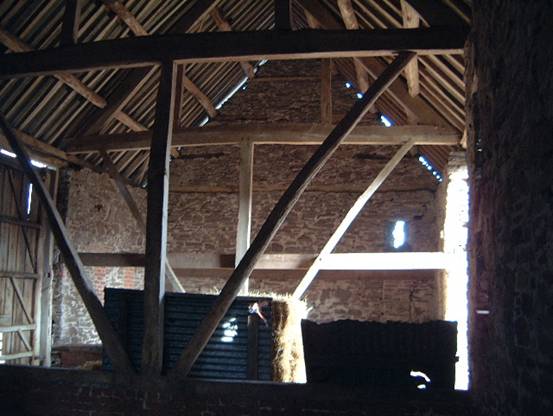
Cover photograph: A view of the threshing bay in the stone barn.
Contents:
Summary ...................................................................................................................................................................... 4
1.0 Introduction..................................................................................................................................................... 4
2.0 Geological and Historical Background............................................................................................................ 6
2.1 Geological Background.............................................................................................................................. 6
2.2 Historical Background................................................................................................................................ 6
3.0 Project Aims and Objectives....................................................................................................................... 8
4.0 Methodology................................................................................................................................................... 8
4.1 Field Methodology..................................................................................................................................... 8
4.2 Processing Methodology............................................................................................................................ 8
5.0 The Results..................................................................................................................................................... 9
5.1 The Buildings............................................................................................................................................. 9
6.0 Conclusions.................................................................................................................................................. 29
7.0 Condition of the building stock and recommendations.................................................................................. 30
8.0 Archive Deposition....................................................................................................................................... 32
8.0 Archive Deposition....................................................................................................................................... 32
9.0 Publication and Dissemination Proposals..................................................................................................... 32
10.0 Appendix............................................................................................................................................................ 33
General Bibliography............................................................................................................................................. 33
Cartographic Material............................................................................................................................................. 33
Copyright............................................................................................................................................................... 33
Figures:
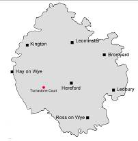
Figure 1: Location plan for Turnastone Court. 5
Figure 2: A plan of the farm buildings of Turnastone Court. 9
Figure 3: Detail from the 1830’s Ordnance Survey Surveyor’s Plan. 10
Figure 4: Extract from the 1840’s tithe map. 11
Figure 5: Extract from the 1880’s Ordnance Survey the map. 11
Figure 6: sketch of one of the reused timbers from the Wainhouse. 13
Figure 7: Sketch drawing of truss construction (16th -17th century). 15
Figure 8: Detail of the lap dovetail construction for the south frame and west gable end. 16
Figure 9: A sketch drawing of the external south frame. 17
Figure 10: A sketch drawing of the ventilation slots in building 9 with timber lintel 21
Figure 11: Plan of the buildings showing materials used for construction. 29
Figure 12: Possible phase plan of farm buildings. 29
Figure 13: Tithe map with apportionments. 30
Plates:
Plate 1: The Watkin’s Family. 12
Plate 2: The rendering that now covers the front of Turnastone House. 12
Plate 3: The south-west view of the piggery. 14
Plate 4: The south-west post of the threshing bay in Barn 4. 15
Plate 5: Corner post of the south frame and the west end gable of building 4. 15
Plate 6: The north frame of building 4. 16
Plate 7: The north frame of the west bay of building 6. 18
Plate 8: The roof supports against the south side of building 4. 19
Plate 9: The east gable end of building 8.. 20
Plate 10: The west gable end. 21
Plate 11: The west and east trusses either side of the Threshing bay in building 9. 21
Plate 12: The north door to the Threshing bay in building 9. 22
Plate 14: the east gable end of building 15. 24
Plate 15: Detail of the ceiling joist of the loft floor in building 15. 24
Plate 16: Decorative blue brick lozenges from the brick built buildings of 19xx. 25
Plate 17: The east elevation of buildings 17-18. 25
Plate 18: The open fronted cattle shed of building 17. 25
Plate 19: Looking south towards the Dutch Barn. 26
Plate 20: The east side of buildings 20 and 21. Building 20 is to the left of the plate. 27
Plate 21: Archway under the privy of building 21. 27
Summary
Archenfield Archaeology conducted a program of building recording at Turnastone Court, Turnastone, Herefordshire, as part of on-going research into the history and archaeology of the Turnastone Court estate.
The survey showed that the buildings of the farm complex can be divided into several development stages ranging from the Grade II* listed, mid 17th century timber barn (building 4) to cow sheds built as late as 1940’s. The earliest map evidence shows the timber barn (building 4) and the stone barn (building 9) and the original house (on the opposite side of the road to the present house).
The timber barn (building 4) is the earliest building in the east-west orientated north range of buildings (4-8). Later additions have been added onto the west end with a single bay (building 5) attached to the west gable of building. Two extra bays (building 6) have been added to the west of building 5 and now forms the west end of this range of buildings.
The east end of building 4 has been replaced by a replaced by a recent brick cow house. Two possible bays of building 4, east of the threshing floor, are no longer standing. The charred wood of building 4 possible suggests that the bays were destroyed by fire.
The history of the Grade II* listed stone barn is similar to building 4, with later lean-to additions on the north, south and east walls. The barn, orientated east-west is dated to the 18th century and has 4 bays, two east and one west of an of centre threshing floor and through-way.
The present house and the majority of the brick buildings (2, 3, range 16-18, 20 and 21) are contemporary and built with red brick bonded in a rough coursed Flemish style with blue decorative brick patterning. These were added to the farm complex in the late 19th century and gave the farmyard a more planned, organised appearance.
1.0 Introduction
NGR 335847 236436
Archenfield Archaeology were commissioned by the Countryside Restoration Trust (CRT) to conduct a programme of archaeological building recording as part of the ongoing investigation into the history and archaeology of the Turnastone estate (Historic Landscape conservation management plan, HLCMP). The field work was conducted in April/May 2004 and involved detailed photos, notes and sketches of the archaeological features of the farm buildings at Turnastone Court.
|
|
|
|
| |
|
| |
| Figure 1: Location plan for Turnastone Court Ordnance Survey Superplan data reproduced under license drawing reference number hemc_00003353. | |
Turnastone Court Farm is a 247 hectare livestock farm which had been managed using traditional methods, by the Watkins family for a over a century until recently.
2.0 Geological and Historical Background
2.1 Geological Background
Turnastone Court lies on the north-east/south-west border of the parishes of Turnastone and Vowchurch. It is to the east of Hereford and the River Dore, of the B4348. The underlying Geology is predominantly Lower Old Red Sandstone, with possible outcrops of Limestone in the higher ground to the east of the court.
2.2 Historical Background
Turnastone is a small parish of just 214 hectares (530 acres) in the Golden Valley in south-west Herefordshire.
In 1086 Domesday recorded five manors in the Golden Valley as being held by Hugh l’Asne – Beltrou, Wluetone, Wilmestune, Almundestune and Alcamestune. Of these, only one, Wilmestune, has been identified beyond doubt – Wilmastone.
The derivation of the first part of the place-name Turnastone has been suggested by Bruce Coplestone-Crow.
According to the Hereford Domesday – an annotated copy of the original made a century later - the manor of Wluetone was then held by Robert Turuei. Robert seems to have been the son of Ralph de Tornai who was associated with a chapel of St Leonard in the Golden Valley. The family may have originated in Tournai-sur-Dive, Orne.
The chapel stood at Lower Slough and in 1132 the people of Turnastone were referred to as parishioners of St Leonard. Turnastone is then named from Tournai. Turnastone became a medieval parish but a very small one. It is surrounded on three sides by the parish of Vowchurch - the churches are only 340 metres apart.
Held by Ralph de Tournei (the probable derivation of the name Turnastone or Tourni’s ton) the land unit was called Wluetone in the Domesday and was part of Huge Le Asne’s land (f. 187).
Richard Dansey was “Lord of Turnastone” in 1299, according to George Marshall, and in collusion with Roger Devereux, impeded the Rector of Turnastone and St. Leonard’s Chapel by occupying both with laymen. Within 2 years a John Devereux was made Rector. There is Glebe Land in (the lower part of) Slough Field but this is Cothill Land.
Some of the Manorial rights may nebulously overlap with those of Urishay as the 16th and 17th Century, quartered Coats-of-arms found in the Church include the Arms of Ap Harry/Parry and De la Hay(HRO Y221/11/7, K38D /D/139) . There are three others, (not identified by George Marshall).
In A S Wood’s extracts from Vaughan’s Book (HRO F37/202), Vaughan says that on his estates he has “within two miles of the place [Whitehouse] Timber sufficient for all my Buildings and fire wood enough for all the Artificers”. “Wallstone, Tyle, Lime and Bricke as necessary as any man living”. He addresses one [three?] Lord [s?] deferentially, as one whose ancestors followed theirs into battle, suggesting that Peterchurch, Vowchurch and Turnastone be joined , by Act of Parliament, into one Parish. This would improve the living of the Vicar, ease the ministrations of Vaughan’s “Commonwealth” and make yearly income from lands greater. Turnastone “has but one man to make a Congregation”. He suggests that being patron of two [of the livings] and having other land business and hereditament connections with the Bishop and Cathedral [of Hereford] stand him in good stead. He suggests that anyone who follows his Drowning example will increase his revenues and that all weirs should be removed from the River Wye.
He claims to have four mills in close proximity. These probably were Trefnant, Poston, Chanstone and New Court. After his revelation of the Mole he gets a neighbour to let him build one side of his first weir on their land. He has to sell a tenant of his another piece of land, to mollify him over the perceived damage this weir would do to cowslips, etc on his leasehold pasture. The system has a seven or eight foot “head”. Three Hundred acres could be drowned. The Trench Royal was dug by arrangement with his neighbours and was scoured in 1601. He was assisted by John the Leveller, who eventually fell out with him as he would not credit John as co-adjuctor. Vaughan states that there were no examples to follow but the Mole. He mentions that a man named Hoord or Howorth, from Shropshire had viewed his works in the company of Messrs. Berington, Pearle and Wolrych. Vaughan’s daughter later married a Howorth and inherited the Estates.
The Glebe Terriers of 1607 (HRO HD2/6/82) show that Vaughan enclosed Meadows in 1605. In 1607 he purchases three messuages in Turnaston and Vowchurch (HRO F37/7). One is probably mostly in Vowchurch, possibly that occupied by Humfrey Balle. One may be near Newton St. Margaret’s/ Dolward area and occupied by David John David Howell. The other may be Turnastone Court as the advowson of the Parish Church comes with the package. Howell John David Howell probably occupied this.
In 1629 the Vaughans pass what seems to be the above mentioned three messuages plus other Land purchased from Thomas Philpotts, James Tayler and Widow Lloyd to Epihan Howorth. (Hurrell)Howell John David Howell was probably still in occupation. These lands are all In the Manor of Newton. This seems to comprise parts of Turnastone, Vowchurch (Whitehouse), Newton St. Margarets and possibly Urishay. Known anciently as the Manor of Jenkin ap Richard or Jenkin Pritchard and latterly as Jenkin Pricket. The Philpotts family also has links later on.
Documents relating to the Kempes and Prossers probably do not pertain to Turnastone Court but in 1660 to either Cothill or Dolward (HRO K12/24) and in 1681 a farm in Vowchurch (F94/II/101).
In 1725 the conveyance to Nicholas Phillpotts the elder, of Edgeworth (later Edgeware) by Nicholas Philpott the younger, of London of the Turnastone Estate, etc (HRO O49/2-3) is somewhat confusing as theoretically this should be in the hands of Haseldens. There may be a link as yet undiscovered between the Howorths, Phillpott/Phelpotts and Hasledons/Woods [Snodhill Estate?].
The1743 inscription (HRO K38/D/139) shows a family link. The Somersets are descendents of the Duke of Beaufort. There may be a link between them and either the Boughton Estate or the Nicholson Estates. The Rent Book of the Mannor of Jenking Prichard Alias Newton (HRO F37/4[?]) lists lands in Newton St. Margarets and Snowdle (Snodhill). It also lists the Quarelly, but is more likely to be one at Dolward, Newton or Urishay than Turnastone’s Quarry. That Mrs. Howorth received rents at Turnastone may represent ancient Manorial Links and a settlement for life to support this [old?] Mrs. Howorth.
By 1786 there were still a Howells in village, occupying a House, garden and Orchard that belonged to the Estate, possibly Ladywell (HRO F37/4). In 1794 a poor labourer built a six-foot by ten-foot hovel for himself and family in the King’s Highway between Michaelchurch Escley and Turnastone (HRO Q/SR/82).
At the end of the 18th Century there was legal wrangling over the inheritance of the Whitehouse Estates. A man named William Davies (possibly a distant relation to Wood) acted, at first, for Wood and then against him in matters of Estate business. In a letter of 1800 he complains to Wood over the condition of the roads. No Timber, he says, is to be taken from woods on the estate(s) during the winter months, the residents having recently fixed them at their own great expense. He also complains that the condition of the weir at Poston Lane and how this has long remained unattended to, causing floods to force the people of Turnastone out of their homes and wrecking the road. Davies mentions a scheme to divert the flow away from Turnastone across a Meadow. Could this be Turnastone Meadow? Was the ditch at its north end enlarged C 1800-1840 to replace the Trench Royal’s main flow through the village?
The 1842 Tithe Apportionment shows Weith’s Orles and West/ Weith’s Meadow to be owned separately from Turnastone Court. The Poor Rate for Turnaston, 1845 (F37/190) shows them both the property of Newton Dickenson Esq, who had married Dame Eliza Gratwiche Boughton , C 1842-1845 (Gloucester RO D4 315/3, releases under Marriage Settlement of Newton Dickenson and Lady Boughton). In 1861 there were only 10 inhabited houses with a population of 54.
By 1878 a new house had been built in Redstreak Orchard and the original site is referred to as the Old Buildings. The Field boundaries have changed a bit, near the top of the hill.
It was 1906 before the Golden Valley Railway connected Hereford to Hay-on-Wye. The lateness of this scheme meant that this line was a backwater and its far-fetched aim of a being a potential through-route to Aberystwyth, crossing Wales via Hay and cutting London – west Wales journey times was never to be realised. The line passed through the easternmost tip of the estate, Bridge Meadow. Across the road, equipped with crossing gates, to the south was Vowchurch Station, sited in Glebe Land. A cast-iron water-tower column lies at the edge of the station site.
The Estate went up for sale again in 1912. The field names had changed a bit. The Little Pleck became known as the Station Field. Water for Turnastone Court was piped from somewhere on Weeths Orles/Meadow (HRO E1/6).
In 1947 the weir at Poston Mill was washed away by floods, ending its use as a mill (HRO BD20/19/18). In 1954, having been dormant during W.W.II, the doomed railway was lifted.
No further mentions of Roads, Quarries, Kilns, Water Rights or Disputes have come to light. Access to HRO B47 may reveal much more.
3.0 Project Aims and Objectives
The aims of the project were: -
· To make notes to level I (RCHME) standard of the standing farm buildings of Turnastone Court.
· To conduct a photographic survey of all the major components of the building. To meet this requirement photographs were to be taken using a 35mm SLR camera using black and white and colour print film of general views of the exterior of the building, all exterior and interior elevations and selective internal views and any detailed coverage deemed to be fitting with the character and setting of the building. The photographic survey was to be conducted in accordance with the stipulations laid down in ‘Recording Historic Buildings’ (RCHME 3rd ed. 1996), to meet the requirements for a level 1 building recording project.
4.0 Methodology
4.1 Field Methodology
The following methodology was employed: -
· The building s and their setting were assessed and analysed by suitably qualified employees of Archenfield Archaeology.
· A plan, based on the modern Ordnance Survey Superplan data, was produced to show building materials and initial phases of buildings.
· Photographs indicating architectural features and alterations were taken using a 35mm camera and black & white and colour film.
· The buildings were visited during the period April/May 2004.
· All photographic records and drawing numbers were recorded on the relevant data capture documents in accordance with Archenfield Archaeology’s standard site recording procedures.
· Each photographic exposure was recorded in a photographic log. H.D. Sherlock & D. Lewis were variously in attendance.
· Suitably qualified archaeologists monitored all activity that involved disturbance of the ground surface.
· Archenfield Archaeology conforms to the Institute of Field Archaeologists' Code of Conduct and code of Approved Practice for the Regulation of Contractual arrangements in Field Archaeology. All projects are, where applicable, carried out in accordance with IFA Standards and Guidance or Draft Standards and Guidance.
4.2 Processing Methodology
· All data were entered into a Microsoft ©Access relational database
5.0 The Results
5.1 The Buildings
The numbers for the buildings and the basis for the text are taken from notes by Jean Grundy, April 2004.

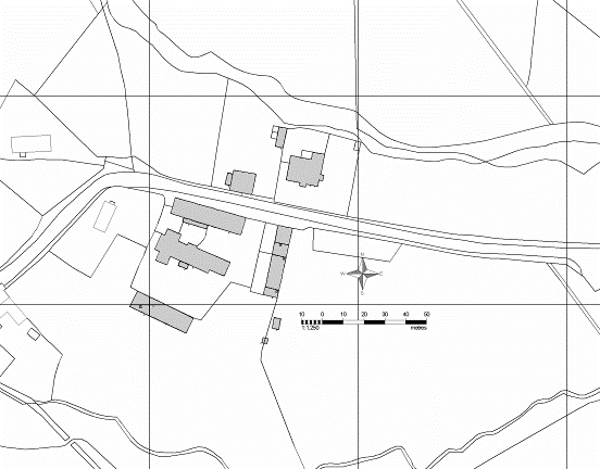
Figure 2: A plan of the farm buildings of Turnastone Court. The numbers on the plan correspond with those of the text
Building 1
The present house at Turnastone Court is not the original. The 1830’s ordnance shows the location of the two barns, buildings 4 and 9, and the location of an earlier house at Turnastone Court.
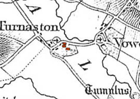
Figure 3: Detail from the 1830’s Ordnance Survey Surveyor’s Plan
The original house was located to the south-east of the stone barn (building 9) and south of the later building 18. No buildings are shown on the opposite side of the road (where the present Turnastone House is situated). The map also shows the parish churches of Turnastone to the east and Vowchurch to the west.
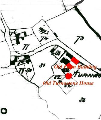
Figure 4: Extract from the 1840’s tithe map
The tithe map shows the original Turnastone Court manor house, and buildings where the recent cow houses (8) now stand. This building was possibly the eastern bays of building 4. Another building is shown where the 1946 building (14) stands. These buildings still existed at the time of the 1880’s Ordnance Survey Map.
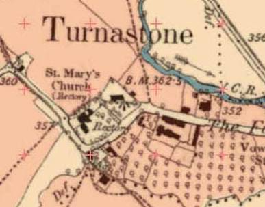
Figure 5: Extract from the 1880’s Ordnance Survey the map.
The 1880’s Ordnance Survey map shows the location of the present house and additional farm buildings 2, 3, 16-18, 20 and 21. The style of the house and farm buildings (with decorative blue brick lozenge patterns) suggests they are contemporary. The Dutch Barn (building 19) is not shown on the map. The present house at Turnastone Court is located to the north, on the opposite side of the road to the original and is described as ‘modern’ in 1878 Ref?
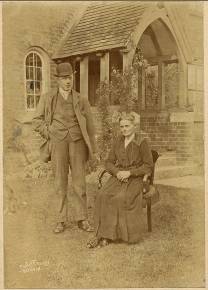
In the background are the bricks of the house with decorative arch patterning over the window. The photo dates to the 1930’s. It was during this period that render of buildings came into vogue. The house is slightly Gothic in design.
The rendering of the house is recent and covers brick (with decorative blue patterning similar to those on the contemporary farm buildings). The two stacks (on the gable ends) are brick with stone dressings. The stacks have blue brick (Diaper pattern) decoration.

Building 2
Wainhouse and granary described as newly erected in 1878. A four-bay brick wainhouse with stout posts that have long jowls and support an open front onto the yard.
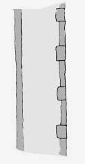
Figure 6: sketch of one of the reused timbers from the Wainhouse
There are 3 posts at the north open entrance to the wainhouse and all are of a considerable size. The posts all have jowled heads, common in the Marches and Herefordshire area.
The timber posts for the partitions in the wainhouse are reused. There are 6 post used in the internal partition walls and all are reused floor beams. The floor beams have a double chamber and regular cuts for floor joist.
The size of the floor beams and the double chamfer, suggests that they were from a large building, possibly the earlier Turnastone house.
The building is of brick with a stone plinth. The east and gables have possible construction breaks with possibly four different styles of brick used.
Granary. The wooden curb approx 0.20m high seats the edge of the floor where it meets the walls. The floor was divided into 5 bays, 3 to the south and 2 to the north of the central passage. Divisions between the bins are of (2 high) plank partitions slotted into grooves, formed by battens and fixed to posts approx 0.50m high. The bins are unusual in having low (1m high is more usual) partitions and being open at the front. Every bin has a door/ventilation window.
The roof is supported on three King post trusses that house 2 tiers of purlins with a wind brace in each pitch.
A wide space has been has been left near the entrance, possibly for turning grain to avoid overheating, and for weighing and bagging. There is a loading door facing north onto the yard with harness and saddlery pegs fixed nearby to the wall plate.
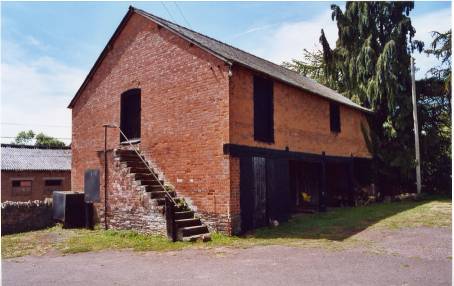
Plate 3: Wainhouse with stone steps leading to the granary.
Building 3
Brick-built, two pen piggery to the north-west of the house. Present in 1912 but not named in 1878. A later garage/shed has possible been added to the south end of the piggery.
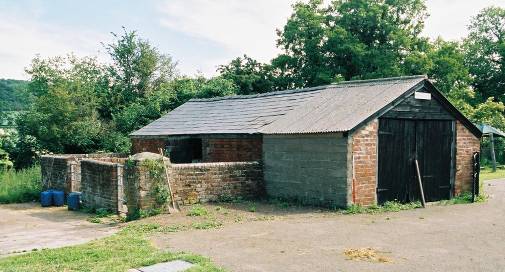
Plate 4: the south-west view of the piggery
Building 4
Grade II listed.
IOE number : 421236
Date listed : 12 NOV 1984
Date of last amendment : 12 NOV 1984
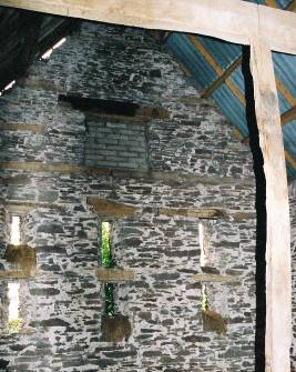
Timber-framed barn of mid-late 17th century date orientated roughly east-west. The east side of the barn was possibly destroyed by fire and has been replaced by brick building (8). The surviving barn has two bays and the frames are three panelled high and built on shallow rubble walls. Some of the panels have an original in-fill of split oak wattle but most are covered by horizontal weatherboards. The floor of the threshing bay is of flagstones while the bays to the west are mixed pebble and earth. The roof of the building is asbestos.
The south frame is missing two passing diagonal braces in the bay east of the west gable end. Empty tenon joints can be seen in the sill beam and the post of the truss. The passing angled braces are a later edition, possibly to stabilize the building after the east bays were destroyed. The east bays have been replaced by the later building (8).
The north frame has a stud missing. The second stud from the west gable end was cut away for the insertion of a pitching hole.
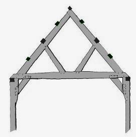
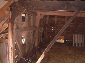
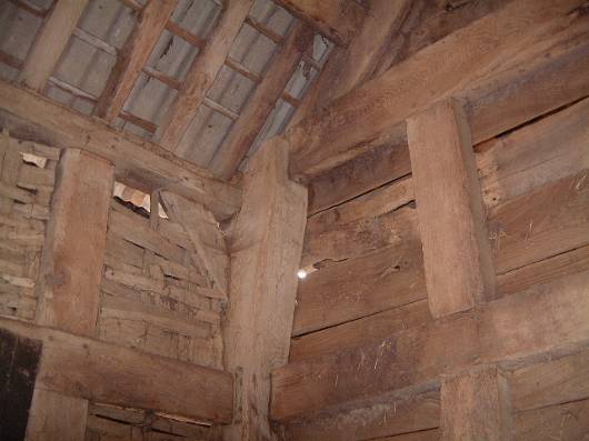
Plate 6: The corner post of the south frame and the west end gable of building 4. Split oak planks can be seen on the exterior of the west gable while original split oak wattle can be seen on the south frame
The original west gable end was fully framed and stave holes at the top of the rails and groves at the bottom suggest a split oak in-fill. The frame is now weather boarded on the outside. The north-south rubble wall and sill that rest on it have been cut at the south end f. This opening was probably inserted for access after the construction of building 5 to the west.
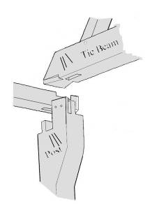
Figure 8: Detail of the lap dovetail construction for the south frame and west gable end
The tie-beam, post and wall plate would have been constructed with the tie-beam lap dovetail assembly. This has been a constant feature of traditional carpentry in England. The purlins have been trenched into the principal rafters.
The trusses have carpenter assembly marks. These are approximately 6cm long and number from 1-3. The marks on the trusses are different from those on the south frame (see Figure 9 over page). Stylistically, the assembly marks are of a different date, but the truss and the frame are contemporary, probably indicating that different carpenters marked the frame and the trusses prior to the barns construction.
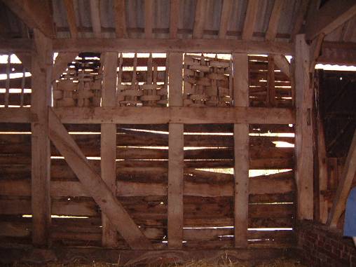
Plate 7: The north frame of building 4. The east passing angle brace is missing
Struts from the post to the tie-beams are on both the north and south frames. The brick wall of the threshing bay can be seen to the right of the plate. An empty mortice joint can be seen on the north-west post of the threshing bay. This corresponds with a similar empty joint on the south-west post and was probably for a horizontal cross beam.
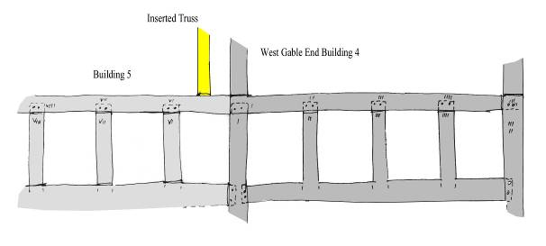
The wall plate and studs have carpenter assembly marks. Building 4 from west to east with 1 to 5 in simple line marks. The marks are chiselled and approx. 3cm long. Bay five (light grey) is a later edition and has roman numeral carpenter marks that run from east to west. The yellow truss is modern, probably inserted as a repair. It was inserted before the fire.
Building 5
A single bay added to the west of building 4. The frame is similar, but more irregular to 4, and without the angled braces. The west gable was originally fully framed but has been cut out. A brick wall has been inserted (approx. 1m high) with raking struts to the tie beam. The sill has been cut on the south side to allow access via a small wooden door. This door would have allowed building 5 to be used with the added threshing bay (building 6). An inserted modern truss has been added to east of the bay. Most of timbers from this bay are reused.
Building 6
Two added bays to the west of building 5 comprise a stone flagged threshing bay or through-way and an open fronted bay that is the west end of the set of buildings. The threshing bay has full-height corrugated iron doors to the threshing floor.
The interior trusses have raking struts from the cranked tie-beams to principal rafters and the west bay is divided off by a panelled partition on a rubble cross-wall. Most of the timber from building 6 is re-used from previous timber framed buildings. The sill beam at the west end has been encased with modern concrete and to the south, has a brick inserted between the rubble wall and the sill. The timbers at the west end are all very weathered and are currently covered by oak planks.
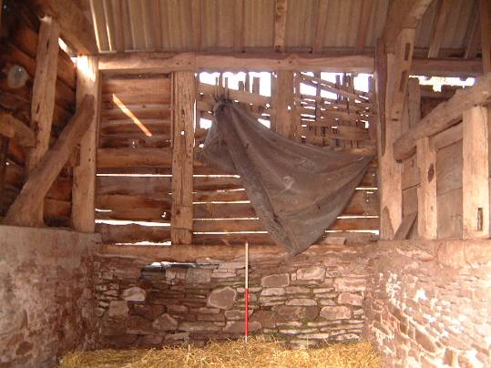
Plate 8: The north frame of the west bay of building 6
Empty peg holes and mortice joints can be seen on many of the re-used timbers. A passing angle brace supports the north-west post of the west gable end of the building. The frame sits on a coursed rubble wall but on the west end, the sill plate has been enclosed in concrete.
Building 7
Shelter shed fixed to the south of buildings 4 and 5. The building has a wooden rack and manger that are fixed to the barn. The north-south stone wall has been widened south to form the manger.
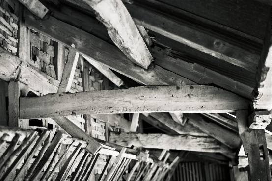
Plate 9: The roof supports against the south side of building 4
The south side of the shelter is propped on five timber posts, two of which are set in round concrete blocks. The shelter has a corrugated iron roof. A hayrack can also be seen (Plate 9 ). The majority of the timbers from this shed have empty joint scars, suggesting that they have been reused from other timber frame buildings.
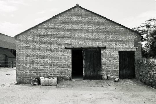
Building 8
Recent brick cow house to the east of building 4. The cow house is separated by internal north-south brick wall. To the west is a animal pen with a loft over. To the east is a room that is divided by a central walkway that separates two animal pens with mangers. The mangers are built into the brick walls of the walkway. The loft of the east pen is entered from a wooden ladder at the east end of the walkway.
The east room is entered by a door from the threshing bay of building 4 and has a window on the south side. The west pens have a door and two windows on the south side and two doors on the east side.
The north-east corner has a possible building break. The front (north) wall of the building is constructed of a different brick type to the cow house and is possible the older.
Building range 9-15 runs roughly parallel and south to range 4-8
Building 9
Grade II listed
IOE number : 421237
Date listed : 12 NOV 1984
Date of last amendment : 12 NOV 1984
A four-bay barn probably built in the late 18th century of finely coursed stone with lime mortar. The walls of the barn have tall, thin vertical ventilation slots that splay to the outside.
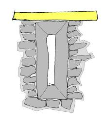
Figure 10: A sketch drawing of the ventilation slots in building 9 with timber lintel
Each bay of the barn has 8 ventilation slots, 2 lower and two upper for the north and south walls. Some of these are in-filled.
The west gable end has 6 evenly spaced ventilation slots that are open. Above the slots is an inserted square in-filled window. The east gable has one slot open, with construction breaks for additional slots difficult to locate. A building (on the 1840’s tithe map) is attached to the east gable. If this building is contemporary it may explain why only one ventilation slot was built into the wall.
All the ventilation slots have wooden lintels of re-used timbers. Re-used timbers have also been used to tie the roof purlins into the east and west gable walls. The timbers would have helped distribute the weight of the purlins and the stone above the void of the ventilation slots.
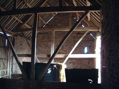
Plate 12: The west and east trusses either side of the Threshing bay in building 9. Ventilation slots can be seen in the background, one open and one closed
Shallow east-west brick walls have been inserted either side of the off centre threshing bay. The walls have sill beams on top. The sill beams are just above ground level (approx 1m) and support central posts and symmetrically placed curved braces that run to the tie-beam. The tie beams carry queen posts. The threshing floor is of flagstones and slightly raised from the concrete yard surface. The flag floor, at the north and south sides, are edged with stone (see Plate 13 below).
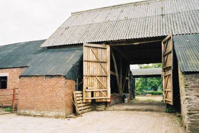
Plate 13: The north door to the Threshing bay in building 9 and the brick lean-to (building 11)
The north door of the threshing bay is wooden and consists of one full height door and one divided into an upper and lower half to allow draught adjustment when flailing. Both doors are approx. 0.45m above the floor, allowing room for a planked ‘lift’. This would have kept the crop in place when threshing.
A stone lean-to has been added to the north wall (building 10) of the barn and a later 19th century brick lean-to on the south (building 12). Both buildings have led to the blocking of ventilation slots on the north and south walls of barn 9.
Building 10
Stone built lean-to attached to the north of building 9. The two bay building is separated by a simple wooden truss with a central post, has doors on the east and west sides and a doorway on the north has been blocked at the bottom to form a window.
The east and west walls butt up against the north wall of building 9.
Building 11
North side 1-bay lean-to with corrugated iron roof. Late 19th century.
Building 12
A late 19th century brick built stable on the south west of building 9. The stable has 3 stalls with a loft over. Along the west wall is a top rail of a hayrack and the east wall has 3 harness pegs to the south of a window.
Building 13
Corrugated iron shed on the south of building 9. Late 19th /early 20th century.
Building 14
Recent brick built building (with 5 bays) butting the east end of building 9. A door in the north-west allows access to building to building 11. Double doors at the south-west open south. Through the double doors and immediately to the west is a single door that gives access to the animal pens. The floor of the building is concrete.
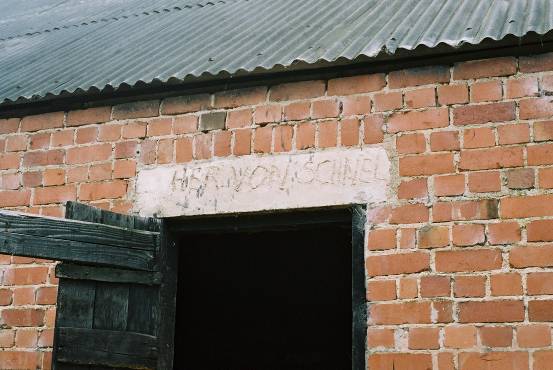
Plate 14: Her Von Schnel. An inscription above a door in the north wall of building 14. The building was built in 1946 by German POWs
Building 15
Building 14 is directly east of 15 and on the north side a construction break is visible between the two the 2 buildings. The east and west of 15 have timber frames while the north and the south walls are of brick. The east end of the building is also the east end of this range.
Most of the rails from the frame have been removed and in-filled with brick. Empty peg holes are visible, marking their former position.
A manger and hayrack are situated along the east frame of the building.

The ‘circle W’ brand can be seen on the inside of the lower timbers of the east frame. This symbol was painted onto newly shorn sheep and was used by the Watkins family for over a century.
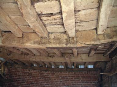
Plate 16: Detail of the ceiling joist of the loft floor in building 15
A later loft was possibly added into the frame. Wall plates are on the north and south brick walls. Beams run east-west with floor joist trenched into the beams. The joist runs north-south. Split oak planks have been used for flooring. The loft would have been entered from a ladder in the entrance way of building 14.
Building range 16-18 is orientated north-south and to the east of the previous two ranges. It is described as recently built in 1878.
Building 16
A brick built building at the north end of this range with the front gable (facing the house) having decorative blue lozenges similar to those on buildings 1,2,3, 20 and 21.
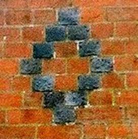
Plate 17: Decorative blue brick lozenges from the late 19th century brick built buildings.
One of the advantages of brick work was the relatively easy way in which it could be decorated and patterning with coloured bricks was one of the most popular methods used. The art of coloured patterning on walls originated in the 15th century in northern France and soon spread to Britain.
The diaper diamond pattern (Plate 17) was by far the most popular pattern in Tudor times but declined after the reign of Henry VIII. Although the pattern continued to be used throughout the 18th century, it was not until Georgian times that it regained widespread popularity.
The building is a stable and chaise with a loft over. Internally is a large compartment for a chaise that is divided by a wooden partition from a large single stall stable with a manger and rack. The fold yard side has a ground level pitching door with a window above. The floor of the stable is of brick sets while the chaise floor is of stone flags. To the south of the chaise house and stable is an animal pen that is boarded on the east side, and separated from the open fronted cattle shed of building 17, by a timber partition. This separated animal pen has a single doorway on the west side of the building.
The front of the building has a single door leading into the stable and double doors leading into the chaise. There is a central pitching door for the loft above the two ground floor doors.
Building 17
A brick shelter shed with 8 bays and a feed way along the east wall. The external east wall, towards the south end of the building has decorative blue lozenges.
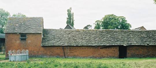
Plate 18: The east elevation of buildings 17-18
The roof of buildings 16-18 are of stone slabs and in the welsh tradition. Stone slabs are pegged together with an oak peg, fixed over a batten that was pegged, or later nailed, to the rafters. Diminishing courses were used, with the largest slabs placed at the bottom of the roof. Both limestone and sandstone slabs can be used.
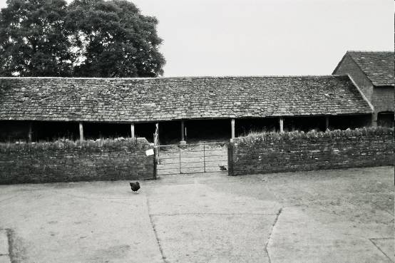
Plate 19: The open fronted cattle shed of building 17. The stone wall would have separated cattle from the main yard
The shed is supported by 5 timber and 2 iron posts on concrete pads along the west front. There is s doorway through the east wall into the walkway. The 6 roof trusses have iron king rods (common in the 1880’s and later) and have carpenters marks from north to south.
Building 18
Two storey brick-built building with decorative blue lozenges on the south gable end. There is a manger against the gable wall. This building could have been the bull house.
There is a central window in the east wall and doorway in the north-west corner of the building and an entrance to the walkway of building 17 at the rear of the building.
Building 19
South of the stone barn is a 6 bay Dutch barn with iron stanchions with timber tie-beams and iron king rods that lead to a curved corrugated iron roof. The roof has three ventilation shafts with caps.
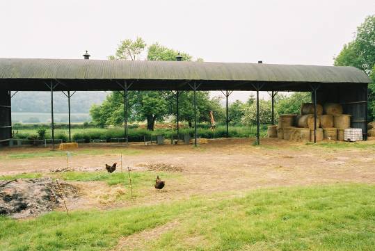
Plate 20: Looking south towards the Dutch Barn
The barn is not shown on 1904 25inch OS map but a hay barn is mentioned in 1910. This however, may refer to an outlying barn with a cattle shelter and fold yard that is no longer standing.
Building 20
Small brick built building with decorative blue lozenges on gable facing house. The building was for ponies or ewes and has a manger on the rear west wall. The building was originally open fronted and supported on timber piers.
Plate 21: The east side of buildings 20 and 21. Building 20 is to the left of the plate.
Building 21
A brick built privy that retains a wooden seat in the south-east corner. An archway runs north-south through the bottom of the building. It runs under the privy and may have acted as a wind tunnel. Archways are fairly standard for privy’s, allowing access for cleaning.
Plate 22:The archway under the privy of building 21
The privy was built on a stone plinth and the eastern elevation is built in stone.
Plate 23: Internal view of the privy.
The toilet seat is in the south-east corner of the building and made of wood. The internal walls are whitewashed.
6.0 Conclusions
In the 18th century great effort was put into boosting agricultural production. Enclosure acts brought together wasteland and remaining open fields into farm complexes with increased productivity. This increase in productivity led to attempts to improve and standardise the farmyard plan.
The main incentives for the improvement of production came with the rising trend of prices between 1750 and 1813, as the population grew from 5.7 million to over 10 million (Lake 1989 pg 102).
The farm buildings at Turnastone Court have built up over a period of time and now form a complex of buildings that stand to the south of the present house. Built some time in the late 19th century the range of buildings to the south (16-18 and 20, 21) are, alone with the buildings 2 and 3, contemporary. Blue decorative brick work patterns that originated in 15th century France and were popular in Georgian times, are present on all of the above buildings.
The earliest buildings of the complex are the grade two listed barn (building 4) that dates to the mid 17th century, and a stone barn immediately to its south. The stone barn (building 9) is also Grade II* listed and dates to the mid 18th century.
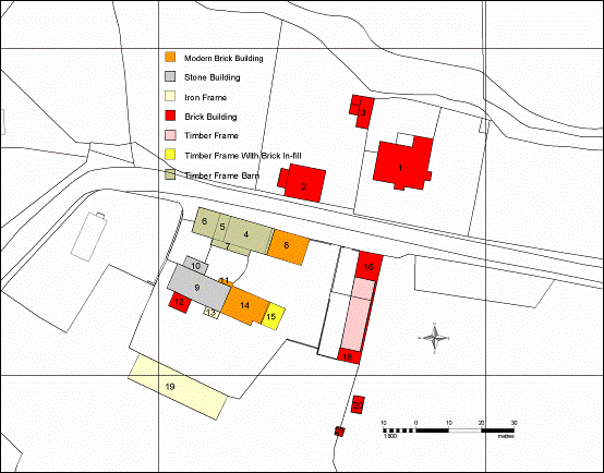
Figure 11: Plan of the buildings showing materials used for construction
Additions have been added to the east of building 4, with three bays attached to the west gable end (buildings 5 and 6). One of the bays was for threshing and is the third (threshing bay) to be added to the complex (buildings 4 and 9 also have threshing bays) and all have stone flagged floors, double doors and bays on either side for storage.
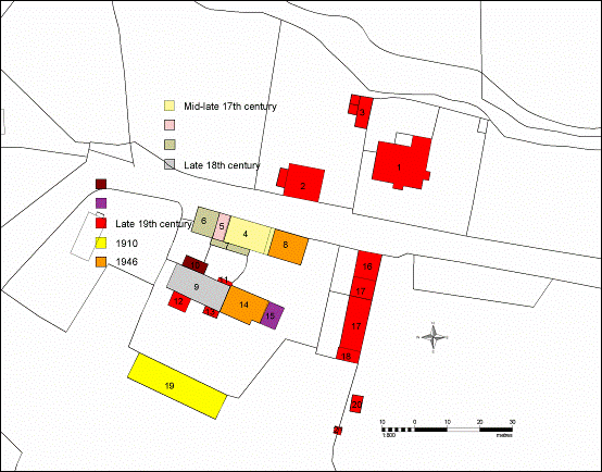
Figure 12: Possible phase plan of farm buildings
The restructuring of the farm buildings after the re-location of the house brought a more organized plan to the farm complex. The north-south orientated range (buildings 16-18) enclosed an area between the two barns and brought an eastern boundary to the yard.
More recent buildings have been added with the brick cow house (building 8) possible replacing some of the east bays of building 4. Lean-to buildings have been added to both of the east-west ranges and a cow house to the east end of building 9. Building 15 is possibly older.
The later buildings of the farm complex are associated with the housing of cattle and probably represent a shift in the farms function, from the earlier buildings for the threshing and storage of crop.
One building conspicuous by its absence at Turnastone Court is a cider mill. Cider formed part of the basic wage of labours that were needed during the summer months for working the land. People employed on yearly contracts, seasonal labourers, men, women and children, all had a healthy daily allowance of cider. The tithe map and apportionment (Figure 13 over page) show orchards and an old hop yard close to the house.
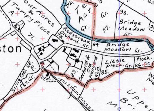
Figure 13: Tithe map with apportionments
The tithe map of 1843 shows that to the east of the original house was an orchard and hop yard with Redstreak Orchard on the opposite side of the road. The farmhouse on the map appears to have several outhouses attached.
Many farm houses had brewing equipment in their backhouses, with a mill and possibly a kiln needed to make a beverage from the apple and hops. It is possible that a mill and other buildings used to brew cider were destroyed with the house.
7.0 Condition of the building stock and recommendations
The complex of farm buildings in existence today at Turnastone Court have been in continuous agricultural use since just after the second world war. The earliest buildings on the site may date from as early as the mid 17th century. All the buildings on the site have been subject to intensive use, alteration and renovation over the years. Several of the buildings are in an advanced state of dilapidation and are urgently in need of major repair and renovation to make them fit for continued safe and efficient use.
The most urgent repair required would appear to be to the roof of the open cow house (building 17). The stone tiled roof has suffered extensively through weathering and the weight of the traditional stone slate has put immense pressure on the roof trusses. Without a complete removal of the existing slates, replacement and reinstatement of the supporting frame and replacement of the broken and cracked slates then this building will quickly become unusable. Similarly the western gable end of the stone threshing barn (building 9) has bowed out at the top and is showing signs of imminent and catastrophic collapse. This must be remedied by taking the gable end down and rebuilding it. This would require listed building consent and this should be sought as soon as possible. Further detailed recording of this and the other listed barn is recommended at an early stage to allow full disclosure of the current state of the building and alteration and renovation work required to bring them back into a fit state of repair to be made to the local conservation officer. The asbestos roof of the timber frame threshing barn (building 4) will need to be replaced. This will require an asbestos handling and removal license to be obtained and a specialist asbestos removal firm must be instructed to carry out the work to the necessary safety guidelines. The roof should be replaced with a suitable roofing material used widely in the locality. Advice on this and other issues regarding the renovation work to the barns must be sought from the local conservation officer. No work should start until the necessary listed building consent has been granted and a program of further detailed recording of the barns has been completed to the recommended Royal Commission standards.
The renovation of the buildings will incur substantial capital costs. This renewal, consolidation and renovation work may be considered to be a suitable candidate for a special project under the current Countryside Stewardship Scheme application. The future use of the buildings should be carefully considered at this stage, and the future plans and detailed requirements of the tenants must be sought as part of the consultation process.
In terms of the below ground archaeological considerations regarding the future development of the site, the cartographic regression survey has located the original location of the original Turnastone Court Manor house, and the footprint of some of the original farm buildings. The footings of these buildings may well be preserved close to the current ground surface, and important and sensitive archaeological features and deposits may still be present in a good state of preservation. Care must therefore be taken when any new building work is planned at the site to minimise the impact on these areas, or to ensure that any impact is mitigated by further archaeological investigation of these areas prior to any construction or clearance work taking place.
8.0 Archive Deposition
The primary project archive, consisting of the original paper records, will be prepared and stored in accordance with the guidelines laid down in the Institute of Field Archaeologists’ guidelines for the preparation and storage of archives. The primary archive will be stored with Archenfield Archaeology.
A copy of the digital archive, stored on CD and consisting of context data, together with the site plan and selected photographs, will accompany the primary archive.
9.0 Publication and Dissemination Proposals
Paper copies of this report will be lodged with the Archaeological Adviser to Herefordshire Council, Herefordshire Sites and Monuments Record and Hereford City Library. A short note on the project will be prepared for publication in the Transactions of the Woolhope Naturalists’ Field Club/other.
CDs of this report, together with the supporting archival material will be available from Archenfield Archaeology.
The complete photographic record, including the negatives, will be retained by Archenfield Archaeology.
10.0 Appendix
General Bibliography
| Documents in Herefordshire Record Office |
|
| Copleston-Crow, Bruce, 1989 | Herefordshire Place-Names , British Archaeological Reports, British Series No 214 |
| Department of the Environment (DOE), 1987 | List of Buildings of Special Architectural or Historic Interest ,Herefordshire HMSO |
| English Heritage May 2004 | Farming The Historic Landscape Caring for Farm Buildings |
| Lake, Jeremy 1989 | Historical Farm Buildings , An Introduction & Guide In association with the National Trust |
| Thorn, Frank & Caroline, eds, 1983 | Domesday Book, Herefordshire. Phillimore |
| Tithe Commissioners, 1842 | Tithe Apportionment for Turnastone Parish, Herefordshire. Public Record Office - microfilm |
|
|
|
Cartographic Material
| Tithe Commissioners, 1842 | Turnastone Parish Tithe Map |
| Ordnance Survey, 1886 | 1st edition 1:2500 plan. County Series |
| Ordnance Survey, 1904 | 2nd edition 1:2500 plan. County Series, Herefordshire |
Copyright
Archenfield Archaeology will retain full copyright of any commissioned reports, tender documents or other project documents, under the Copyright, Designs and Patents Act 1998 with all rights reserved; excepting that it hereby provide an exclusive licence to the client for use of such documents by the client in all matters directly relating to the project.
Ref: rs_gdv_0074