
EWYAS LACY STUDY GROUP: DIGITAL ARCHIVE - MAPS |
|
The links opposite will download images of local maps from the Digital Archive. File sizes may be large, and some maps may be embedded within a more general document. Additional maps and boundary descriptions of some individual property holdings can be found in Manorial Records
|
|
|
|
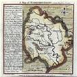
| County MapsEarly maps of Herefordshire
|
|
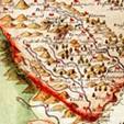
| Area MapsPublished Maps of the whole or part of Ewyas Lacy |
|
|
|
Maps of Herefordshire 1577-1750 [Thumbnails]
|
|
| ||||
|
|
|
|
|
|
|
| ||
|
|
|
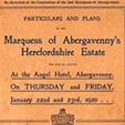
| Estate MapsLocal Estates, from Surveys and Sale Particulars |
|
| Tithe MapsOwners, occupiers and holdings of land by Parish | ||
|
|
| Marquess of Abergavenny’s Estate
|
|
|
| |||
Ref: rs_DA_0010