
Held at: | Hereford City Library |
Reference: | Local Collection |
Source: | Transactions of the Woolhope Field Club, 1916 |
Title: | Guest Contribution: Upper Erging or Insula Eurddil |
Place name: | South West Herefordshire |
Date: | 1916 |
Description:
THE BOOK OF LLANDAFF AND HEREFORDSHIRE PLACE NAMES.
BY THE REV. W. D. BARBER, M.A.
(Read 21st December, 1916).
In the year 1133 Urban or Gwrfan Bishop of Llandaff died at Augusta (Aosta) in Italy in his 57th year. Pope Innocent III had summoned him to Rome to plead his claim to jurisdiction over districts which had been alienated to St. David's and Hereford dioceses soon after the Norman Conquest. Three successive Popes Calixtus, Hotterius and Innocent III, to whom appeals had been made by Urban, wrote to the King, to the Archbishop of Canterbury, to the Bishop of Hereford, and others demanding justice for Llandaff diocese and Bishop Urban; the letters are preserved in the book of Llandaff. The day for a final hearing had been fixed at Rome; and Urban was bringing the deeds, charters, and other proofs in support of the claim when, worn out by 20 years' struggles against powerful opponents, he died on the way.
The Book of Llandaff contains the proofs which Urban was taking to sustain his cause. It was therefore compiled for a purpose, and is more or less suspect. Its " tendency" is obvious. Its purpose failed. The parishes in dispute are still under the jurisdiction of St. David's and Hereford.
The districts in Herefordshire are called Erging, now Archenfield, in the South, and Anerging, or Upper Erging the district from Moccas to Holm Lacy, Aconbury, the Worm and the Dore.
The claim to Anerging was vitiated by the long period which had elapsed, over 300 years, since it had become part of Hereford diocese.
By Offa's day (8th century) this territory had passed to the Saxons and was probably included in the first Bishop of Hereford's (Putta) diocese. A comparison of the names in the two districts shows the thoroughness with which the early invaders did their work. We see almost a complete, but not an entire, obliteration of British names in Anerging, and the survival to our own day of the British names in Archenfield or Erging.
The first name in point of time dealt with in the record is that of Dubritius, Bishop of Llandaff and Archbishop of Caerleon. Much that relates to him is more or less legendary. Briefly, he was said to be the grandson of Pibian or Glofarwg, or Spumpsus, King of Erging early in the 5th century. He was said to have been born of a virgin mother by Divine influence.
Germanus and Lupus consecrated him, circa 465, Bishop of Llandaff. In 490 he was raised to the Archbishopric of Caerleon and South Britain, still possessing Llandaff, which he resigned to S. Teilo in ' A.D. 512. He resigned Caerleon in 519 retiring to Bardsey Island off Caernarvonshire where he died in 522. These dates given in Liber Llandaff are all doubtful. His remains were translated to the new Cathedral at Llandaff in 1120 by Urban and his brother the Dean Esne who compiled the Book of Llandaff and re-edited the old records referring to Dubritius.
I think it is indisputable that some facts underlie the legendary account of St. Dubritius which was compiled in 1120, and the place names in Anerging and Erging tend to confirm this.
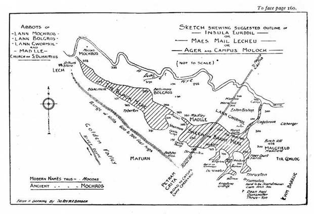
Maes Mail Lecheu or Insula Eurddil. Campus Molocheu or the Field of Moloch .
The boundary of this district is given from Moccas to Tir Conloc along Wye. Its southern boundary, I suggest, was the marshy land between Shenmore and Madley and the depression between Blakemere and the Moccas woods towards Hereford; and its eastern boundary was Tir Conloc (the land of Conloc) which stretched from the Wye to Ystrad Dour [Valley of the Dore]. What Canon J. Taylor writes of the Thames may with equal force be applied to the Wye :-
" Instead of being-confined with regular banks the river Thames must have spread its sluggish waters over a broad lagoon which was dotted with marshy islands. This is indicated by the fact that the Anglo-Saxon word ea, or ey, in island enters into the composition of the names of many places by the river side which are now joined to the mainland by rich pastures, Bermondsey, Putney, Osney, Whitney, and Eaton or Eton."
Now in the district under consideration bordering Cage Brook we find is Eaton Bishop. Eaton is an Anglo-Saxon word, ea-ton, the settlement on the island.
A further proof is given by the heights of the land above sea level (Ord. Map). The highest point in this area of Eurddil is near Wormhill 319 feet. The land gradually descends in the west to a brook entering the Wye near Preston and rises again until the Wye is reached at Moccas. " Dubritius built an oratory at Mochross in a corner of Eurddil." Between the ridge of land and Stockley Hill and the Batcho to the South the land sinks in one place to 205 ft. above sea level; the low land near Wye being marked 239 feet.
Assuming this lowland to the south to have been the Southern boundary of Insula Eurddil the names Shenmore and Blakemere give an indication of the impression which the meres made on the first Anglo-Saxon settlers.
The deepest part of the mere was called the Blackmere. It was shaded by wooded heights which cast their shadows over the mere at sundown. The more open and shallower mere to the east gave the name Shen mere or bright, shining mere to the settlement close to Madley, but separated from it by the narrow morass crossed by a causeway which a few years since connected Madley with the Castle and Shenmore. There are two names outside but bordering on the island to which I will briefly refer Meer Court and Mawfield both of them overlooking the low land, the former bed of the mere. The name of Mawfield has been identified by Mr. E. Phillimore with the name Maes Mail Lecheu or Molochu the other name for the Island of Eurddil. It occurs in old charters as Mawlcfield, the Field of Moloch. If this be so it must be for the same reason that Walford-on-Wye got its name, Wales ford not in Wales but the ford in to Wales, Mawlefield not in Maes Mail but contiguous to it.
If we are to believe the tale about Dubritius's birth it was because Eurddil was found holding her son in her lap, at a spot " where a stone is placed in testimony of the wonderful nativity of the boy," and the place is called Madle because therein was born the holy babe.
I would suggest another origin for the name, Field of Moloch.
Just above Moccas is the smaller Stonehenge now named after King Arthur, but centuries older than his reputed time. The hill on which Arthur's Stone is placed overlooks the Maes Mail Lecheu, and from that derives its most ancient Keltic name.
Quce ab aliis vocatur Maes Mail Lecheu " Lann gwornoe" in campo Molochu.
The unborn yet quick infant exposed on the funeral pyre by its grandfather suggested to the Saxon Christians Moloch and thence the latin form of the name. But the name of Dubritius is connected with other place-names in Anerging and I must trouble you with a brief recital of the facts.
Before the Saxon invasion had reached the West, when Magna and its suburbs still stood just across the Wye from Ynys Eurddil and Caerleon and Caerwent or Venta Silurum in Lower Gwent, shone with the splendour which Giraldus described in the 12th century, before Gildas heard the " groans of the Britons," and at least 80 years before King Arthur is said to have instituted his Round Table (if it is not the invention of a later age), King Pibianus or Spumosus, a much afflicted man (two slaves were continually employed in wiping the foam from his lips) dwelt at the place afterwards called Moch-ros.
One day returning from hunting he called his daughter Eurddil (gold locks?) to wash his head. Then he discerned that his daughter was about to become a mother. In his anger he ordered his servants to enclose her in a sack and throw her into the Wye, which refused to drown her. Again and again she was cast in with the same result.
The father then commanded the servants to burn her on a funeral pyre. They, setting fire to this left her, but the next morning Eurddil was found sitting on the funeral pyre uninjured with the holy babe Dubritius in her lap.
The infant was brought to the King who took him up in his arms. The babe touched his lips with his hands and immediately the flow of spittle ceased. A cure was wrought by the babe. Thus, without human agency, or as is implied by Divine influence, Dubritius was born. This story of course throws doubt on the earlier part of the Book of Llandaff.
Now for the place names in Anerging and the authenticity of its charters.
In the island of Eurddil, also called the Maes Mail Lecheu or the field of Moloch, are :-Madle, Mochros, Bolgros, Gwormoe.
Now I quote verbatim :-" Who (Pibianus) when he knew that he had been healed by the touch of the infant, rejoiced greatly like one who had come to a harbour after having suffered shipwreck and, he who at first was as a roaring lion, was now turned to a lamb, and he began to love the infant above all his sons and grandsons and of that place Madle (i.e., mad, good; lie, place), he made him heir, and also of the whole island, which took its name from his mother Eurddil, that is Ynys Eurddil which by others is called Maes Mail Lecheu."
Is there any record of a Church at Madley before this one in the legendary story invented and edited in 1130? In the time of Bishop Berthgwyn, early 7th century, we read that on a certain day two men came from Llanerch Glas, who had quarrelled, and said " Let us agree to go to Madley, to the church of St. Dubritius and both swear on his altar... to be reconciled."
But Clodock Church was much nearer to them, the way was long, so they went to St. Cleodicus's altar instead - on their return to Llanerch Glas they fell out by the way, with a common result in these old records, the murder of one and the suicide of the other. Apart from the 12th century life of Dubritius, that is the only early reference to Madley,
The second name in the island is Mochros. This is the record :-
" Dubritius remained with his disciples for many years directing their studies in his native district, namely,Ynys Eurddil, having chosen a place convenient for wood and fish in a corner of that island giving it the name of Mochros," moch hogs, rhos place, or more correctly marsh or promontory.
He was bidden by an angel, in a dream, to build an habitation and oratory where he should see a white sow and her pigs. On awaking he at once set out with his disciples and finding the sow and pigs, built as commanded. Although commanded to build in the name of the Holy Trinity we find the church at Mochros in King Ithael's time (7th century), dedicated to St. David, Llandewi Mochros and after the Saxon Conquest to St. Michael and All Angels.
Madley too forgot Dubritius and was, and is now, dedicated to the B.V.M. and All Saints.
But where was the site of the old church of Dubritius at Madley ? There are no grants of land recorded as for other churches. Could the original church have been at Bellimore, Bolgros ?
I quote from Canon Bannister's " Place Names of Herefordshire" under title Bellimore:- It would seem that Bellimoor is simply a translation into English of Bolg-ros which is compounded from Welsh bolg the root of several words meaning a paunch, and ros, a moor, heath" the meaning of the word thus being the heath or moor of the Paunch or belly. But there is another explanation of a much simpler character—which is indicated by taking the word more as equivalent to N. F. gros - British Mawr great. Without descending to particulars it is obvious if both elements of the word are British it must refer to the discovery made by Pibianus respecting Eurddil, and the name which is on 20th century lips – Bellimore - is the word used by those who believed the story of the Virgin birth of Dubritius and gave land to commemorate it.
The gros in 1130 is a veiling of the grossness of the original word by a refined Norman Welshman. I give the words of the grant - " Gorfodw, King of Erging, having gained a victory over the Saxon nation giving thanks to God and for the Prayers of Bishop Ufelwy and his clergy, granted in alms to him and his successors under the refuge or protection of St. Dubritius, St. Teilo, & c, for ever, the land called Bolgros (Bellimore) on the banks of the Wye at some distance from Mochros of the quantity of 3 uncias (circa 324 acres) and the land having been given as an endowment, Bishop Ufelwy with his clergy went round the whole of its boundary, sprinkling holy water, the Holy Cross with the Holy relics being carried before; and in presence of the King with his witnesses built a church in the middle thereof in honour of The Holy Trinity and St. Peter and St. Dubritius. He also granted all the land free of all fiscal tribute to God and to the Bishop who was present and all his successors at Llandaff and with all Commonage in field and in woods & c.
Witnesses, Clergy, Ufelwy, & c.
Whosoever will keep it may God keep him and whoever will separate it from Church of Llandaff may he be accursed."
Ufelwy is said to have been suffragan to Oudoceus, Bishop of Llandaff about 566 A.D.; apparently the first Saxon invasion had been repulsed and the land was given as a thank offering.
Bellimoor (Lower, Middle and Upper) is in Preston parish. Abbots of Bolgros attested several early grants in Anerging, and although there were Abbots of Mochros, of Bolgros and of Gwormoe all in the Island ol Eurddil there was no Abbott of Madley recorded.
Canon Bannister writes :-" English settlers evidently understood it as meadow of Mada, and the name took this English form." I would suggest as early as Crida in Offa's time when it was founded.
The last name of a church in Madley district is Gwormoe.
" Gorfodw gave 108 acres for a church dedicated to the Holy Trinity and there placed his minister Gwormog to remain to perform service for the benefit of the church." The same witnesses attest this grant as that of Bolgros, 3 miles distant. Later entries shew that it was in Insula Eurddil as:-
" Athrwys, King of Gwent granted to God and St. Dubritius, & c., and in the hand of Bishop Comereg the church of Cynfarch (St. Kinmarch, near Chepstow) and all its territory" - including Lann Gwormoe in the field of Moloch. Lludneu, Abbott of Bolgros, and Aclhaiarn Abbott of Lann Gwormoe, were among the witnesses.
I would suggest that Wormhill is the site of Gwormoe Church. It is astride the ancient road, Stoney Street, and is now a farmstead. The occurrence of the British man's name Gwormog and river Gwormog Worm shows that there is a British as well as Anglo-Saxon derivation of Worm.
In conclusion I note that Canon Bannister derives Blakemare 1273, Blakemar 1291, Blakemere 1341, from Blseca's mere, a Saxon man's name and Shenmore, or Shenmer, either from a variant of Swinmoor, i.e., Moch-ros, or from O. E. Scearn, dung. Older forms not being available, I prefer the contrast of black mere and bright mere, for the. reasons stated, but whatever their origin they testify to the existence of the lakes and therefore to the southern shore of Insula Eurddil.
Tir Conloc extended from Wye to Ystrad Dwr. Conloc was a man's name, mention is made of the heirs of Conloc.
In the Golden Valley Cwm Barruc and Lann Gerniw are mentioned in early grants; all trace of them is lost. There is a Cwm on the line of Stoney Street and a Kerry, (? Caerau). But I have a suggestion to make with regard to a boundary name under Cwm Barruc. Pibianus gave 4 uncias (432 acres) at Conloc on banks of the Wye below Eurddil as far as Cwm Barruc in Ystrad Dour (Dore valley) probably 432 acres of cleared and settled land, the rest being wood and marshland. Tir Conloc would include Clehonger, Allensmore, Kingstone, Thruxton and part of Abbeydore, in which parish the church of Cwm Barruc was probably situated.
GRANT TO CWM BARRUC. - Know all persons that the two sons of Pebian (uncles of Dubritius) Cynfyn and Gwyddai have given 3 uncias (324 acres) of land at Cwm Barruc to St. Dubritius and his household and attendants with all surrounding commonage in field, waters, wood and pastures, i.e., acreage of cleared land with a much larger domain. The boundaries are latitude de Lech usque ad pe.tram Crita (Cryda). A Roman road, Stoney Street, runs from Abbey Dore (where it was uncovered lately by Mr. Jack) to Magna or Credenhill - Petram Crita may be the stone called Crita, but why not lech as above ? In the Llanwarne boundaries the Jacinthine Way (per viam jacinthinam) is also named in another place " petram jacinthinam." For the same reason I suggest that " petram Crita" is Stoney Street and lech the other boundary, some miles up the valley, Arthur's Stone. Cryda may have been the destroyer of Magna whose name survives in Credenhill.
The last extract gives a picture of the unsettled state of the district in the 6th and 7th centuries. " Be it known that great tribulations and plunderings happened in the time of Teithfallt and Ithael, Kings of Wales which were committed by the most treacherous Saxon nation principally on the borders ot Wales and England towards Hereford, so that all the border country of Wales was nearly destroyed and much beyond the borders in England and Wales especially about the River Wye on account of the frequent diurnal and Nocturnal encounters which took place between both countries. After a time peace being established the land was restored to its owners and its former authority, although destroyed and depopulated by foreign people and an uncommon pestilence (yellow plague temp. Teilo, A.D. 560). An alliance of Britons was formed in these parts, and King Ithael restored to the survivors their patrimony although for a time destroyed, and to Bishop Berthgwyn (temp. St. Augustine late 6th and 7th century), to Dubritius, Teilo, and Oudoceus, and all Bishops of Llandaff for ever."
Observations:
This item provides further clues as to the nature of the Post Glacial landscape of South Herefordshire, see also the paper on the Postglacial Landscape of SW Herefordshire on this site.
For “unciae” as a unit of land measurement peculiar to this part of Herefordshire in the 6th to 8th centuries see article by Wendy Davies
Rev William Davin Barber was Rector of Thruxton and Vicar of Kingstone. He was a member of the Woolhope Club. He died aged 59 in 1918. In his Orbituary Notice the Rev A T Bannister aknowledged him as a historian with an interest in the history of Archenfield.
Article is reproduced from the Transactions of the Woolhope Naturalists’ Field Club with the permission of the Central Committee
Ref: gc_gdv_3006