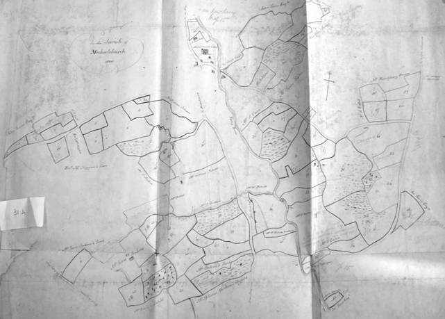
| Michaelchurch - Copyhold |
| No. 1 to 25 Inclusive
Copy granted 24 May 1805 to Francis Johnson of Michaelchurch
for the Lives of Grantee then aged 33 (dead), Benjamin Lewis (eldest son of Benjamin Lewis of Newton, Farmer) then aged 9 and James Johnson (eldest son of Jas Johnson of Llanveynoe, Farmer) then aged 7
See Court Roll page 248
Michaelchurch [Tithe Map] 724, 726, 739, 733, 734, 738, 739, 740, 741, 742, 745, 780a, 782, 783a, 786, 788, 789a, 841, 856, 872, 873, 874, 883, 884, 908, 925. 926, 928,& 791.
Acreage 96a.1r 22p
In possession of Johanna Johnson, called “Old House”
Reserved Rent 6/1/2
Another Life was afterwards inserted on the death of said Francis Johnson viz. James son of Jas Johnson of Michaelchurch, Publican, who however died not many years afterwards. see Court Roll page 33 |
| No. 26 to 34 inclusive
Copy granted 1st March 1859 to John Roberts of Michaelchurch, Farmer
for the Lives of Stephen, Eliza and Joseph Roberts then aged resptly 24, 9 and 5 (children of Lessee)
see New Court Roll
Michaelchurch, except No. 32, Tithe Map 735, 853, 862, 863, 878, 879, 881, 885, 922 & 927
Acreage 25a.3r.
No. 32 in Newton Tithe map 32
Acreage 1-2-8 |
| No. 35 to 41 inclusive
Copy granted 1st March 1859 to said J. Roberts of Michaelchurch, Farmer
for the Lives of William, John and Richard Roberts then aged resptly 28 19 and 3 (other children of Lessee)
see New Court Roll
Michaelchurch Tithe Map 730, 743, 744, 746, 747, 782, 784a, 785a & 787
Acreage 31a.1r.33p
Richard dead July 1882 |
| No. 47, 48
Copy granted 2 Dec 1768 to Nicholas Johnson
for the Lives of Thos Perkins (dead) and Archibald Maclean and Catherine Maclean the aged resptly 19 and 17 (children of Hugh Maclean of Birmingham and afterwards of King’s St. Westminster).
See Court Roll page 62. Expired
Forms part of “Bridge” Farm belonging to Richard Barton, Esq“ and now in the occupation of Alexandra Gordon.
Worth 18/- per ann.
Michaelchurch Tithe Map 722, 723, & 725. Acreage 3-3-1 |
| No. 49, 50, 51, 52
Copy granted 29 Dec 1858 to Elizabeth Wathen of Llansaintfread Co Mon, Spinster
for the Lives of Wm J Reginald Jones (now Herbert) of Clytha then aged 17, John Wathen Davies 8 (son of John Davies of Newport Mon., Letter Carrier) and Geo. Pritchard 13 (son of Geo Pritchard of Whitehouse Farm Llanv-[?] nigh Usk)
see New Court Roll Book
Michaelchurch Tithe Map 854, 855, 859, 860, 861, 871, 875 & 880
Acreage 13a.3r.37p
Rent 2/7½ |
| No. 53, 54, 55, 56, 57
Copy granted 29 Sept 1790 to Simon Exton of Peterchurch, Surgeon
for the lives of Simon, Ann and Sarah Exton then aged respcty 10, 12 and 11 (children of Grantee)
see Court Roll page 193. - Expired
Now Revd Thos Powell, Dorstone held at Rack rent. Valued by Harris and self at £10.17.6 per ann.
Nos. 53 & 56 in Newton Tithe Map 34 & 20. - Acreage 5a.3r.26p
Nos. 54,55 & 57 in Michaelchurch Tithe Map 847, 849, 850 & part 868
Acreage 15a.3r.14p |
| No. 58, 59, 60, 61, 62, 63, 64
Copy granted 23 August 1839 to Margaret Powell of Llangua Co Mon. Widow
for the Lives of Grantee then aged 67 (dead), Wm Watkins of Ewyas Harold, Yeoman then aged 40 and Elizabeth Watkins (daur of Wm Watkins) then aged 8
See Court Roll page 456
Elizabeth (query Eliza) Watkins now the wife of Thomas Vaughan of the Parish of Rowlstone
Reserved Rent 3/-
In possession of Wm Watkins well [?]
Michaelchurch Tithe Map 851, 852, 864, 865, 866, 867, 890 & 891
Acreage 29a.1r.39p |
| No. 42, 43, 44, 45, 46
Copy granted 30 Sept 1819 to James Pritchard of Michaelchurch Yeoman
for the Lives of Grantee then aged 36(dead) and James and Thomas Pritchard aged resptly 11 and 3 (sons of Grantee)
See Court Roll page 350
Grantee dead, James (the son) alive and resides on premises. - Thomas also alive.
Fence on No. 44 taken up and a portion of the field let into freehold.
Trees on No.42 shamefully lopped and a great number felled.
Michaelchurch Tithe Map 777, 778, 786a, 787a, 799 & part of799a
Acreage 16a.2r.36p
Reserved Rent 1/6 |