
Held at: | Private collection |
Reference: | gc |
Source: | Research on Tithe Map schedule |
Title: | Some Land owners in part of St Margarets, Map 5 |
Place name: | St Margarets |
Date: | 1844 |
Description:
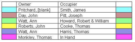
Some properties and their owners in part of St Margarets at the time of the Tithe map of 1844. Including that part of St Margarets known as the Upper Maescoed.
Holding | Owner | Occupier |
House | [blank] Pritchard | James Smith |
House | John Day | Joseph Pitt |
Mapp's House | Ann Watt | Robert & William Howard |
Land | John Roberts | Thomas Cooke |
House (plot 263) | Ann Watt | Thomas Harris |
House | Thomas Monkley | In Hand |
|

to see associated maps click here
Observations:
Many of the small holdings on this map are in the area known as the Upper Maescoed . Upper Maescoed originally an open Common that was, over a long period of time, subject to piecemeal enclosure. The properties were mostly copyholds held for ‘lives’ by ancient custom of the Manor. They are recorded by copy in the rolls of the Court Baron. Many were included in the 1920 Estate Sale of the Marquees of Abergavenny.
Ref: gc_stm_3005