
Held at: | English Heritage |
Reference: | AI/26/2003 |
Source: | Original publication |
Title: | Longtown: A Medieval castle and Borough – an Archaeological Investigation Report by English Heritage |
Place name: | Longtown |
Date: | 2003 |
Guest Contribution: Introduction
We are most grateful to English Heritage for their kind permission to reproduce this archaeological investigation report on our website. This work is the most thorough study available of the archaeology of the castle and borough of Longtown and is a particularly valuable addition to our database. We are delighted to be able to make it more widely accessible.
Ewyas Lacy Study Group
ISSN 1478- 7008
Longtown, Herefordshire
Archaeological Investigation Report Series AI/26/2003

The Welsh border follows the eastern ridge of the Black Mountains. Longtown Castle lies between this and rolling farmland to the east.

LONGTOWN, HEREFORDSHIRE
A medieval castle and borough
ISSN 1478-7008
Archaeological Investigation Report Series AI/26/2003
| County: | Herefordshire |
| District: | South Herefordshire |
| Parish: | Longtown |
| NGR: | SO 322290 |
| NMR No: | S0 32 NW 1, 13, 46 |
| SAM/ RSM No: | Herefordshire 20 |
| SMR No: | 1036, 4576 |
| Date of survey: | March 2003 |
| Surveyed by: | Nicky Smith and David Field |
| Report author: | Nicky Smith |
| Illustrations by: | Deborah Cunliffe |
| Photography by: | Nicky Smith |
© English Heritage 2003
Applications for reproduction should be made to English Heritage NMR services: National Monuments Record Centre, Great Western Village, Kemble Drive, Swindon SN2 2GZ Tel: 01793 414700 Fax: 01793 414707 e-mail: nmrinfo@english-heritage.org.uk
Comments or queries regarding the content of the report should be made to the author at the address above.
World Wide Web: http//www.english-heritage.org.uk
CONTENTS
|
| LIST OF FIGURES |
|
| 1 | INTRODUCTION | 1 |
| 2 | GEOLOGY AND TOPOGRAPHY | 2 |
| 3 | PREVIOUS ARCHAEOLOGICAL WORK | 3 |
| 4 | ARCHAEOLOGICAL CONTEXT | 5 |
| 5 | HISTORICAL BACKGROUND | 6 |
|
| 5.1 Before the castle | 6 |
|
| 5.2 Ewias Lacy Castle in the medieval period | 7 |
|
| 5.3 The castle’s later history | 9 |
|
| 5.4 The new town of Ewias Lacy | 9 |
|
| 5.5 Ecclesiastical history | 10 |
| 6 | DESCRIPTION OF THE REMAINS | 12 |
|
| 6.1 General | 12 |
|
| 6.2 The castle | 12 |
|
| 6.3 The borough | 18 |
| 7 | DISCUSSION | 26 |
|
| 7.1 The origins of the sub-square earthwork enclosure | 26 |
|
| 7.2 The masonry remains | 27 |
|
| 7.3 The development of the settlement | 28 |
| 8 | METHOD OF SURVEY | 31 |
| 9 | ACKNOWLEDGEMENTS | 31 |
ENGLISH HERITAGE Longtown iii
LIST OF FIGURES
| 1 | Location plan | 2 |
| 2 | Longtown Castle in 1718, drawing based on a map by B Fellowes (in British Museum) | 11 |
|
3 |
Longtown Castle, English Heritage survey 2003 |
13 |
|
4 |
The motte and the keep |
16 |
|
5 |
Re-used 12th-century mouldings in an enlarged window of the keep |
17 |
|
6 |
Fragments of curtain wall on the eastern side of the inner bailey |
18 |
|
7 |
Gateway to the inner bailey |
19 |
|
8 |
Longtown Castle and settlement, 1:2500, English Heritage 2003 |
20 |
| 9 | Settlement earthworks, Outdoor Education Centre, Longtown, English Heritage survey 2003 | 22 |
| 10 | Settlement earthworks, Pigeon House field, English Heritage survey 2003 | 23 |
|
11 |
St Peter’s Church situated beyond the castle’s southern ditch |
24 |
| 12 |
Settlement earthworks in 1965. Now partially destroyed by modern development (CUCAP AMQ66 7 Dec1965) |
25 |
|
13 |
Proposed sequence of development for the castle and borough |
29 |
ENGLISH HERITAGE Longtown Castle iv
1 INTRODUCTION
The civil parish of Longtown lies in south-west Herefordshire, close to the border with Wales. The archaeological remains here comprise a castle (NMR SO 32 NW 1; SMR 1036), built to control and exploit annexed Welsh lands, and a borough (NMR SO 32 NW 13 & 46; SMR
4576) planted beside it. The castle survives today as earthworks capped by ruined masonry, which includes a fine round keep. Earthworks and other remains of the former borough line a road which leads south from the castle and through the present village. Both the castle and a large part of the borough are Scheduled as an Ancient Monument (Herefordshire 20). The castle masonry and the area inside the bailey walls are also under English Heritage guardianship, although this does not extend to the earthworks upon which the masonry stands or to any of the earthworks beyond the curtain wall, most of which lie on common land (Fleming undated). There is open access to both common and guardianship areas of the castle. The remains of the borough and its defences lie on private land within the present village or on farmland adjacent to it.
Between January and March 2003 an analytical survey of the archaeological earthwork remains was carried out by the Swindon Archaeological Investigation team following a request from Dr Paul Stamper, Inspector of Ancient Monuments for the West Midlands Region. The purpose of the survey was twofold. Firstly the pace of new development in the village has increased significantly in recent years and poses an immediate threat to the archaeological remains of the medieval borough as well as to the castle’s setting. Prior to the survey previously unrecorded earthworks had been recognised outside the scheduled area, during an archaeological assessment of Longtown by Hereford and Worcester County Council. Some of these remains were already under threat from building development. A comprehensive and detailed plan was therefore needed to determine the extent of the newly recognised features, to revise the boundary of the Scheduled area and to assist site management and preservation work. The second aim of the survey was to improve understanding of the castle and borough. The extent and layout of the castle’s baileys, including the nature of controversial earthworks to its north, have long been a subject for debate. The layout of the medieval borough, its extent and the nature of its defences have also been poorly understood.
ENGLISH HERITAGE Longtown 1
2 GEOLOGY AND TOPOGRAPHY
Longtown is situated at SO 321292, approximately 10 miles south of Hay-on Wye and 9 miles north of Abergavenny. The predominant rocks of the area are the Old Red Sandstones (Bartlett 1984, 1) with Dittonian Sandstone Marls and Grits forming the lower slopes of the Black Mountains. The soft sandstone provided the red colour of many Herefordshire castles
(Shoesmith 1996, 2), including Longtown. Local soils are of the Bromyard Association,
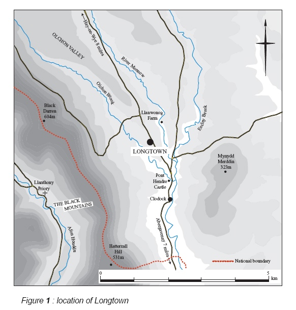
Figure 1: location of Longtown
which are well-drained, fine and silty, suitable for cereal growing, stock rearing and hop growing (Soil Survey 1983).
The landform of the area is characterised by hills and valleys running north to south, with the castle and village being set on the top of a low ridge, between the confluence of the River Monnow and its tributary the Olchon Brook. The castle is situated on a ridge at the northern end of the village. The Black Mountains dramatically overshadow the village and castle to the west, with summits at Black Darren and Hatterrall Hill rising to 604m and 531m OD respectively, and a patchwork of pasture fields and rolling farmland to the east.
The ridge top position of the castle and town affords them a degree of natural defence, but places with more precipitous approaches exist in the surrounding area. The castle has steep approaches on its western and eastern sides, and to a lesser extent on its southern
side but the ground is level to the north. The defensive potential of the terrain may thus have been less important than the strategic value of its situation in the Normans’ territorial advance.
ENGLISH HERITAGE Longtown 2
3 PREVIOUS ARCHAEOLOGICAL WORK
Longtown castle has attracted the interest of both historians and archaeologists for many years and an idea that it was superimposed upon a Roman camp was put forward in the early 19th century (Duncumb 1812, 274). The first detailed and accurate survey of its remains was carried out by the Ordnance Survey (OS) in 1888, while The Victoria County History and The Royal Commission on the Historical Monuments of England produced small scale surveys of the site in 1908 and 1931. Between 1934 and 1952 the castle was the subject of a further study which described the remains in detail and included a brief note on its history (Kay 1978). In recent years interest has grown in the borough, which was included in a list of medieval towns (Beresford & Finberg 1973, 123). An account of Longtown Castle and borough featured in Shoesmith’s general volume on Herefordshire castles (Shoesmith 1996,
167- 174) while Remfry has published detailed volumes on both Longtown Castle and the Castles of Ewias Lacy in general (Remfry 1997 & 1998). The City of Hereford Archaeology Unit has also examined the history of Longtown and the structural development of its castle (Morriss & Williams 1991).
In addition to these studies which have considered the monuments as a whole, Longtown Castle and Borough have been the subject of numerous small-scale excavations. In the early 1960s excavations took place within the castle bailey (Remfry 1997, 29) and in 1965 a section was cut, probably across one of the castle’s outworks, although its exact position is not clear (Buteux 1996, 3). In the 1970s the Ministry of Works acquired the castle in a dilapidated state and began clearing the site of rubble and consolidating its remains. Excavations took place within the inner bailey in 1972. The results of these have never been published although the results of an excavation of the keep, in 1978, were published recently (Ellis 1997).
Later archaeological examinations have generally resulted from impending development. Watching briefs took place during the construction of a new school to the north of the castle (SMR 24829), during work in the Outdoor Education Centre car park (Bartlett 1984, 2), at Green Cottage (NMR Excavations Index; SMR 31818) and west of the church (Edwards 1989). A further watching brief was undertaken during remedial work on the castle in 1994 (Appleton-Fox 1995). Archaeological evaluations and watching briefs have also been undertaken adjacent to the Police Station (Taylor & Woodwiss 1988; Buteux 1996, 3) and in the area of the Central Kitchens (Stone 1997).
Since the 1980s geophysical survey has been used to study several parts of the castle and borough, but difficult geological conditions and 19th- and 20th-century dumping have meant that results have often been inconclusive (Bartlett 1984, 1; Edwards 1989; Buteux
1996, 3). Areas examined have included the eastern bailey, the playing fields of the new school, areas east and north of the Central Kitchens and land to the rear of the Sun Inn. In 2000 a further geophysical survey was undertaken in the field opposite the Crown Inn
ENGLISH HERITAGE Longtown 3
following a planning application to build a village hall there (Hoverd 2000).
Most recently, Longtown has also been considered in its context, as part of wider archaeological studies. In the 1990s archaeological features visible on aerial photographs were transcribed at 1:10000 scale by the RCHME, as part of their Marches Uplands Mapping Project (NMR 1197913, Sheet SO 32 NW). In 1996 an archaeological assessment of Longtown was included in the Central Marches Historic Towns Survey by Hereford and Worcester County Council (Buteux 1996).
ENGLISH HERITAGE Longtown 4
4 ARCHAEOLOGICAL CONTEXT
The earliest archaeological remains to have been found close to Longtown are two early Bronze Age burials unearthed during ploughing at Olchon Court Farm on the lower slopes of the Black Mountains, approximately 3 miles north-west of Longtown (Marshall 1932). A stone circle and a concentration of early Bronze Age cairns also lie on Hatterrall Hill (Olding 2000, 40). It has been argued, from the scarcity of hillforts and enclosures at high altitudes on the Black Mountains, that there was widespread abandonment of upland areas in the Late Bronze Age and Early Iron Age periods (Olding 2000, 56). The area later to become Longtown may have been situated within the territory of Walterstone hillfort , a relatively low- lying univallate hillfort 3 miles to the south, although Black Darren hillfort also lies only about 2 miles to the west (Olding 2000, 58).
During the Roman period Ostorius Scapula led a campaign against the tribes occupying Herefordshire hillforts and took Roman rule west as far as Usk, Hay-on-Wye and Leintwardine. A frontier was preserved between the military area in Wales and the rest of the province, which was under civilian control (Shoesmith 1996, 4). Forts were built at both Hay (Clyro) and Abergavenny (Gobannium) while a Roman villa was situated nearby at Walterstone (Page 1908, 173). It has been suggested that Longtown was on the course of a Roman road. It lies approximately midway between the sites of Gobannium and Kenchester (Magnis) Roman town (Duncumb 1812, 274; Kay 1978, 3) and 1934, xlix), but the course of Roman roads in the area is by no means certain. An alternative route could have been by way of the Golden Valley (Margary 1973, 343).
During the early medieval periods Clodock, less than ¾ mile to the south, was the apparent focus of activity. Although its church (NMR SO 32 NW 44/SMR 1458) dates only from the 12th century or later, a 9th-century inscribed tombstone found beneath its nave, suggests that it has earlier origins. Apart from being the parochial centre of Ewias Lacy, it may also have been named after king Clawdwg who is said to have had a place named after him at the spot where he died (Remfry 1997, 1). A quarter of a mile to the north of Clodock church Pont Hendre motte and bailey castle (NMR SO 32 NW 2;SMR 1038) lies adjacent to a bridge, which could have Roman origins. Pont Hendre castle is probably the predecessor to Longtown Castle (see p7 below) and one amongst numerous motte and bailey castles in the vicinity.
ENGLISH HERITAGE Longtown 5
5 HISTORICAL BACKGROUND
5.1 Before the castle
The area later to become Longtown was known as ‘Ewias’, meaning ‘sheep district’ in the mid 10th century, when its bounds were first described (Remfry 1997, 1). Prior to this its history is obscure. It is said variously to have been part of the territory of Merthirclitauc in the early 8th century (Copplestone-Crow 1989, 56) and to have been ‘Ewias’, in the territory of King Clydawg ap Clitguin in the Dark Ages (Remfry 1997, 1). Later Ystrad Yw and Ewias were reputed to have been granted by King Edgar to Hywel ap Morgan Hen (Remfry 1997,
1). By the time of Edward the Confessor’s reign (1042-66) Ewias may have been a Welsh dependency with ties to Mercia (Marshall 1938, 143). Edward gave lands in Herefordshire, where the Welsh king Grufyydd was causing problems, to his Norman friends Osbern Pentecost and Richard FitzScrob. They are said to have built several early castles, including one at Ewyas Harold, 6 miles to the east of Longtown, but were forced to flee following a rebellion during which Hereford was sacked (Remfry 1997, 2). Although the Saxons had advanced towards the boundary of the later lordship of Ewias, it remained in Welsh hands in 1066 (Marshall 1938, 142; Houston 1999; Perry 2002, 21).
Following the Norman Conquest the southern Welsh border was entrusted to William FitzOsbern (Shoesmith 1996, 13). He, Walter de Lacy and Ralph Bernay pushed into Welsh lands and founded castles at points such as Wigmore, Clifford, Monmouth and Chepstow. At this time king Rhydderch was said to have ruled Ewias, under King William, but petty lordships had been established on the fringes of the Black Mountains before Walter de Lacy’s death in 1085 (Marshall 1938, 147). The Domesday Book records as belonging to Walter’s son, Roger, ‘one land called Ewias within the boundary of Ewias. This land does not belong to the castlery (Ewyas Harold) nor to the hundred (Cutshorn). From this land Roger has 15 sesters of honey, 15 pigs when men are there and justice over them’. The entry suggests that Roger had only a tenuous hold even over these lands and that itinerant Welshmen were living there (Shoesmith 1996, 16, 168). When the Normans expanded into Wales it was a question of piecemeal military conquest by individual barons who set up lordships one at a time and defended them against internal revolt and external attack by Welsh princes or other lords. The Norman lordship of Ewias Lacy was thus not synonymous with the old territory of Ewias but a mixture of lands carved out by inheritance or conquest. The early estate probably consisted of Walterstone, Rowlestone, Llancillo, Dulas and Cusop (Remfry 1998, 1).
ENGLISH HERITAGE Longtown 6
5.2 Ewias Lacy Castle in the medieval period
Throughout the medieval period Ewias suffered from successive conflicts. During the late 11th century Roger de Lacy rebelled against the king on more than one occasion, resulting in his exile, and his estates were conferred upon his younger brother, Hugh (Remfry 1997,
5). Pain FitzJohn succeeded Hugh de Lacy and following his death in 1137 bitter conflict over the inheritance of Ewias Lacy became inextricably linked with the wars of the Anarchy, which raged across the area, while it was further ravaged by Welsh attacks. By 1143-8
Gilbert, the son of Roger de Lacy, appears to have held Ewias Lacy, and he soon came into conflict with Joce Dinan, holder of Ludlow (Remfry 1997, 7-9). After the accession to the throne of Henry II in 1154, Gilbert devolved his Herefordshire estates upon his son, Robert, who was succeeded by his brother Hugh in 1162 (Remfry 1997, 10). Hugh was intent on increasing his lands at the expense of the Welsh. It was probably he who added the central region of Ewias around and to the north of the present castle to the original de Lacy lands during the 1170s and 1180s. He was murdered in 1186 and his lands seized, although his son Walter was restored to them in 1189 (Remfry 1997, 13).
In 1187 the Pipe Rolls refer to two castles ‘Castelli de Ewias et Novi Castelli’ upon which £37 was spent. These castles are thought to have been Pont Hendre motte and bailey and Longtown respectively (Coplestone-Crow 1989, 58). A new castle implies a new lordship (Mc Neill 1992, 34, 39) and the two castles appear to have been in use for a period of time when the de Lacy’s control over Ewias was tenuous. Whether the old ‘Castelli de Ewias’ was constructed by the de Lacys or acquired in warfare is not clear. Characteristically the
‘Novi Castelli’ was built on the edge of the parish, on land probably used as common by the old settlement, since the area upon which it stands is common to this day. Once the de Lacys consolidated their hold over the area and penetrated further north the old castle at Pont Hendre would have become redundant and begun to decay while the ‘new’ castle was updated with the addition of masonry defences.
Ewias continued to be a centre for conflict in the late 12th century, as a Welsh attack on Abergavenny in 1182 shows (Kenyon 1996, 124). Painscastle, less than 15 miles to the north of Ewias Lacy, was also attacked by the Welsh several times throughout the 12th and early 13th centuries and its castle was destroyed more than once (Salter 2001). Before the end of September 1200 Walter had agreed with his neighbour William de Braose that the latter would take charge of the de Lacy lands in England and Normandy. Subsequently Walter married William’s daughter. In 1208 the Braose Rebellion occurred, resulting in conflict between the years 1208 and 1211, waged from the de Lacy and Braose centres of Weobley, Ludlow and Ewias Lacy. By the end of August 1211 King John had captured all the main conspirators and the event possibly saw the destruction of both Ewias Lacy castles for there is no mention of them during this period (Remfry 1997, 15-16). In 1213 Walter’s lands were restored and he remained loyal to the king throughout the Barons War (Remfry 1997, 17). He became Sheriff of Herefordshire in 1216 (Morriss & Williams 1991) and it was probably between then and 1231 that the stone keep and bailey were built at
ENGLISH HERITAGE Longtown 7
Ewias Lacy. Certainly strong defences were still needed to protect against Welsh attack. Between 1212 and 1218 Llywelyn ap Iorwerth was consolidating his position in north Wales and much of the south and in 1231 nearby Brecon, as well as Neath and Radnor, fell to the Welsh. In 1233 the conflict came even closer to Ewias Lacy when Abergavenny Castle was burned (Kenyon 1996, 122, 124). In that year, Henry III visited Ewias Lacy, on his way from Hay to Abergavenny, and ordered Walter and other Marcher lords to attack the King’s enemies and provision their castles for sieges (Remfry 1997, 22-3).
Walter’s death marked the end of the de Lacy era at Longtown and in 1234 John FitzGeoffrey acquired the castle. He was one of a number of barons ordered by the king to make peace with Llywelyn. By 1241 he was also one of many dispossessed Marcher lords who attended royal arbitration with Prince Dafydd, indicating that Welsh gains had been made in Ewias Lacy (Remfry 1997, 24). The estate then passed to John Verdon, who was succeeded by his sons Nicholas, and Theobald in 1274 (Remfry 1997, 24). Theobald was mostly resident in Ireland during which time the new castle became a local trouble spot, with complaints made by the Prior of Llanthony about cattle rustling, harassment and trespass on his lands (Remfry 1998, 6-7, 10). From this time until 1283 Llywelyn’s last wars raged (Pounds 1990, 166, 178: Remfry 1998, 8) and property owners in the area felt further at risk after Gilbert de Clare’s Welsh tenants rose against him in 1294 (Platt 1982, 90). Theobald returned from Ireland to become embroiled in conflict between Humphrey Bohun and Gilbert de Clare, to the annoyance of the King who temporarily stripped him of his lands (Remfry 1998, 8-9). Theobald died in 1316 and Ewias Lacy passed to Bartholomew de Berghersh (Remfry 1997, 25).
The castle continued to play a part in the defence of the area into the 14th century. In 1317 the Sheriff of Hereford was ordered to garrison it with 30 men. In 1327 a close and 3 mills were associated with it and by 1328 it was valued at £44 12s. Prisoners were held at the castle in 1356 (Ellis 1997, 67-9). A constable and porter were last mentioned in 1360 with later references recording foresters and stewards (Ellis 1997, 69), suggesting that the estate had become more important than the castle, although in 1367 levies were raised from it. On the death of Bartholomew’s son in 1369 the castle passed through the hands of the Despencer and the Beauchamp families (Remfry 1997, 25) and from the 15th century onwards it was the property of the Nevilles, Lords of Abergavenny (Robinson 1869, 121). All these families lived elsewhere and the castle was probably left to decay. Between 1402-8 however, Owain Glyndwr’s rebellion saw frequent raids in the area which left Hay semi-derelict for over a century (Noble 1964, 69). This threat resulted in a temporary reprieve for Ewias Lacy Castle when Henry IV ordered, in 1403, that it and 21 other decayed castles in south Wales and the English borders, be re-fortified against the Welsh and supplied with provisions (Remfry 1997, 25; Thompson 1987, 20). After the suppression of this rebellion no more major campaigns were undertaken and unoccupied castles in the area became redundant. By 1526 Henry ap Llywelyn is recorded as paying 6d for the ‘farm of the garden near the castle’ and 6d for ‘one parcel of land under the house of the castle’ (Reeve’s Account 17 Henry VIII).
ENGLISH HERITAGE Longtown 8
5.3 The castle’s later history
No documentary records of Ewias Lacy Castle having played a part in the English Civil War are known, although a 17th-century cannon ball was discovered near the keep in 1865 (SMR 19465). There are further references to three or four similar cannon balls having been found nearby, while pottery of 16th and 17th century date was also unearthed during excavations (Buteux 1996, 9). According to local tradition the castle was slighted by cannon during the Civil War (Watkins 1932, 186-7). Most castles capable of use would have either been repaired or wrecked at this time and so it seems quite plausible that the castle was slighted and possible that it even saw minor action. Slighting of castles was not confined to the period of conflict. As late as 1659 the House of Commons debated which strongholds should be preserved, with a policy of destroying inland fortifications. The demolition work was generally carried out by the County Committees or Deputy Lieutenants whose records have not survived (Thompson 1987, 144-156).
The stone from Ewias Lacy Castle would have been used for building works from at least the 17th and 18th centuries onwards. By 1692 ‘the site of the castle of Longtowne’ was leased out, along with ‘one aunchint house, a meadow of four acres, two closes of pasture one of three acres and one of four acres. Excepting liberty of stewards of Lord Abergavenny to hold Ewias Lacy manorial court within the house as accustomed’ (Gwent RO D1583.2.12). A map of 1718 by B Fellowes, shows the ruined keep, a house and a shop, while the inner and outer baileys appear to have been used as a yard and a garden respectively (BM 2820(4) PS 207061). The castle was also the site for a gallows, last used in 1790 (Shoesmith 1996, 174). The levelled area (Figure 3, v) in the bank immediately north of Castle House could have been the platform where the gallows once stood. In 1869 a school was built within the eastern bailey (Shoesmith 1996, 168). This was extended and a house, Castle Lodge, built immediately to its north some time before 1904, by which time the house and shop of 1718 had been demolished (Ordnance Survey 1904). Several lean-to buildings were constructed against surviving lengths of the curtain wall and in 1930 a modern stable stood next to the eastern gate turret and exposed foundations of a small building were visible against the eastern retaining wall of the outer bailey (RCHM 1931, 184). All these buildings have since been cleared away and the school has been converted into houses.
5.4 The new town of Ewias Lacy
The Domesday Book accounts for a small itinerant population at Roger de Lacy’s lands in Ewias, but it was not until after the construction of the castle, that a new borough (SMR 2358/ NMR SO 32 NW 13, 46) was founded. The precise date of the foundation is not known but it was first documented as ‘Nova Villa in Ewias Lacy’ in the Curia Regis Rolls of 1232 (Coplestone-Crow 1989, 57). Presumably the intention was to establish a market and income for the castle, although initially at least there must have been some competition between the new borough and the earlier centre around Clodock. In c1234 a burgage is first mentioned at the new town (Beresford 1988, 451) and in 1271 tolls for the borough amounted to £21 (Ellis 1997, 69). By 1310 the town was said to have 100 burgesses (Beresford 1988,
ENGLISH HERITAGE Longtown 9
451) although this figure seems very similar to the numbers recorded for other Herefordshire boroughs and so might be purely nominal (pers comm M Bowden). Accounts for ‘Ewias Burgus’ survive for 1492-3, 1500-1 and 1503-4 (Herefordshire County Record Office G33/I) although it was no longer functioning as a market centre by 1500 (O’Donnell 1971, 191). In 1540 a reference to ‘Longa Villa in Ewias Lacy’ is made by Dugdale (Coplestone-Crow 1989, 57), indicating that the settlement straggled along the road for some distance at that time. After this it always seems to have become known as ‘Longtown’. By 1640 Longtown was still prosperous enough for its chapel to be re-roofed (Morriss & Williams 1991, 6) and the Hearth Tax of 1655 lists 128 hearths (Harnden 1984) showing that it was still a sizeable village even if its borough status had dwindled. It held two annual fairs up until the 1890s (Buteux 1996, 2) and its sheep fair continued into the 1950s (pers comm Mrs Brierley).
5.5 Ecclesiastical history
In ecclesiastical terms Longtown was never a centre of great importance. Prior to 1852 the large and ancient parish of Clodock encompassed Newton, Craswall and Llanveynoe, as well as Longtown (Houston 1999). Together with the remaining parishes of Cutsdown Hundred, it lay firstly within the diocese of Llandaff and later in St Davids (Houston 1999). In common with other Norman lords, the de Lacy family were instrumental in establishing monastic houses. Walter de Lacy founded nearby Llanthony Priory and endowed it with the tithes of Clodock church and various manors in the vicinity. He also established Craswall Priory between 1215 and 1225 (Houston 1999). Both priories were vulnerable to attack in this war- ravaged area and Llanthony was abandoned for some time in 1136 following a Welsh revolt (Ellis 1997, 67). It was probably not until the 13th century that St Peter’s Church was constructed as a chapel-of-ease for the community of Ewias Lacy. It has a 13th-century chancel and possibly a porch of the same date, with a tower of the early 15th century, but the rest of the church has been the subject of heavy 19th-century restoration. A re-used 12th-century capital serving as a piscina (RCHM 1931, 179-181) may have come from an earlier chapel, perhaps within the castle.
ENGLISH HERITAGE Longtown 10
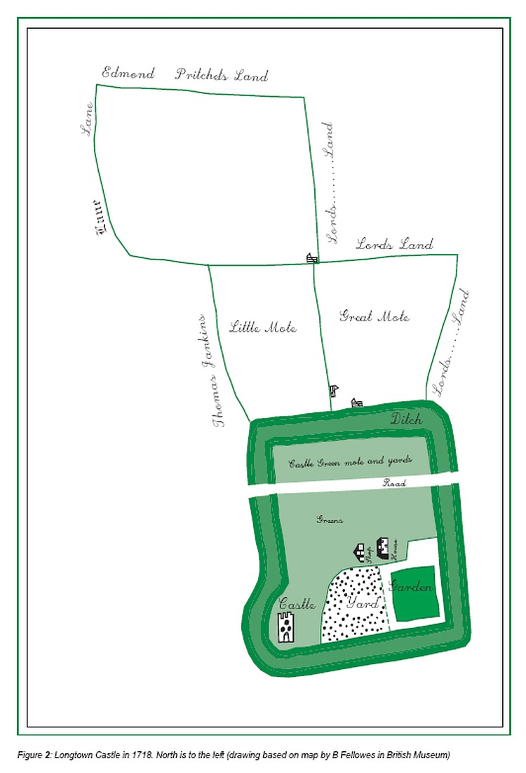
Figure 2: Longtown Castle in 1718. North is to the left (drawing based on map by B Fellowes in British Museum)
ENGLISH HERITAGE Longtown 11
6 DESCRIPTION OF THE REMAINS
6.1 General
The archaeological remains at Longtown consist of a sub-square enclosure with a large motte superimposed upon its north-west corner. A masonry castle overlies the western half of the enclosure. This includes an impressive stone keep on top of the motte. Another sub- square earthwork enclosure is attached to the southern side of this enclosure and a similar one may have existed on its northern side. The main road through the present village cuts through these enclosures and marks the western edge of former settlement earthworks lining the road leading south from the castle.
6.2 The castle
The earthworks of Longtown Castle comprise a sub-square enclosure of approximately 1.21ha, defined by a single bank with an external ditch. Internally the ground level is higher due to the natural rising topography, although excavated evidence has shown that the change in level has been enhanced by an overburden of debris which has accumulated to a depth of 1m within the bailey (Ellis 1997, 71). The bank therefore rises as much as 4m high externally, but only about 2.5m internally. The ditch survives on the northern, southern and eastern sides where, although heavily silted in places, it remains up to 1m deep. On the northern side the former ditch now carries the road to Llanwonog. Here its outer edge has been partly filled in to accommodate houses and gardens which stand 1.3m above the road surface behind retaining walls. On the western side of the enclosure the ditch has been filled in to accommodate Jews Lane. We do not know whether the ditch originally carried water, although the western arm was under water at the time of the survey and two natural springs issue into the ditch (Figure 3, a). A field on the eastern side of the ditch was also named Cae Ffynnon meaning ‘well field’ on a map of c1800 (Jeffreys c1800).
There are six gaps in the rampart. In the eastern side, one lies close to the north-eastern corner of the enclosure, where a small footpath (figure 3, f) from the direction of Llanwonog and the Salem Baptist Chapel cuts across the rampart diagonally and leads towards the present village. To the south of this is a larger breach (Figure 3, g) flanked by inturned ramparts and a corresponding causeway across the ditch. From its asymmetric position and form it seems unlikely that this is an original entrance to the enclosure, although it could still be of some age. It now has no obvious purpose, other than as a farmer’s entrance, but it is flanked by two small building platforms (Figure 3, h) and leads towards a complex of probable settlement earthworks (Figure 3, j). A further breach (Figure 3, k) lies immediately east of the motte and was probably created when the motte ditch was cut. Two breaks in the rampart exist where the main village road runs through the enclosure breaching its northern and southern sides. Stonework on the western side of the road at the southern
ENGLISH HERITAGE Longtown 12
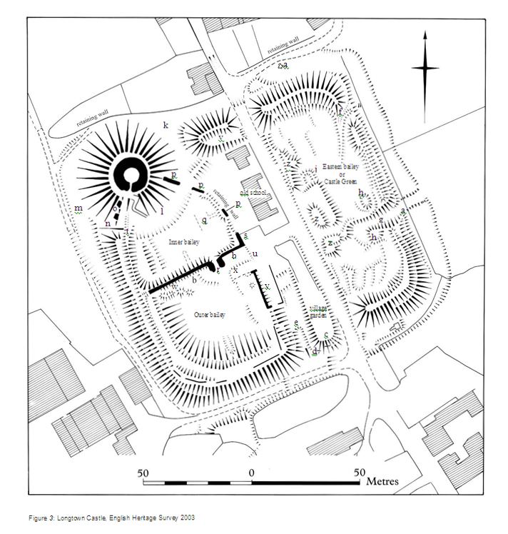
Figure 3: Longtown Castle, English Heritage Survey 2003
breach has been interpreted as part of a possible gateway (RCHM 1931, 183). Further stonework was seen protruding in two places in this area (Figure 3, c & d), one at the foot of the rampart and one close to its top. These appear to be the remains of a revetment wall. Close to the centre of the southern rampart, only 20m west of the break through which the road passes, is a further gap in the rampart. This carries a hollowed track-way (Figure 3,e) which runs in a northerly direction into the centre of the enclosure. It is the only one of the breaks in the rampart which lies symmetrically with the enclosure, being situated centrally in its southern side. The fact that it also carries a hollowed track-way and is flanked by imposing ramparts on either side suggests that it may have been the original entrance.
The steep conical castle motte straddles the north-western corner of the enclosure. It is an imposing feature, standing approximately 11m high, with a circular stone keep on its summit. Its ditch has been filled in but traces of it can be seen in the inner bailey where a broad shallow depression (Figure 3, l), at most 0.3m deep, curves around the foot of the mound. Further traces can be seen to the west, where a further shallow ditch (Figure 3, m) lies between Jews Lane and the mound and also where the enclosure rampart has been cut immediately to the south of the mound (Figure 3, n). As with the main enclosure ditch, the motte ditch carries a track on its northern side which has been partly filled in to accommodate houses and gardens behind a wall. This wall retains an external ground level of 1.7m.
The keep is a massive round structure constructed of local shale-like sandstone rubble with ashlar dressings. It has been the subject of several detailed studies (eg Morriss & Williams 1991; Remfry 1997, 34-35, 39). Its walls, 4m thick, survive two storeys high above an under-croft which penetrates its earthen mound. It has suffered partial collapse on its south- western side, where two large fragments of masonry (Figure 3, o) lie on the slopes of the motte. The positions of the floor levels are marked by ledges in the interior. Three half round turrets are equally spaced around the outside face of the tower, one containing a fireplace, one a spiral staircase leading to the upper floors and one situated next to a projecting garderobe. The turrets do not show on the ground plan because the keep has a chamfered plinth. This is now robbed of its facing stone. The first floor windows have been enlarged at some point and decorated with fragments of re-used 12th-century mouldings. The 13th century, the date of the earliest fabric of St Peters Church, would seem a likely date for these modifications because episodes of church re-building may coincide with modifications to the seignurial site, perhaps using the same craftsmen (Creighton 2002, 110). The re- used masonry may have come from a 12th century chapel, perhaps situated within the castle. Chapels tended first to be in the keep and from the 13th century onwards at the side of the bailey and against an exterior wall (Pounds 1990, 240). Round keeps are rare and the example at Longtown is one of a group of 19 such keeps to have been recognised in the Brecon region (Shoesmith 1996, 170).
A masonry curtain wall, approximately 3m thick enclosed an irregularly shaped area south of the keep, encompassing the western part of the earthwork enclosure described above. Until recent times this wall joined the keep (Ordnance Survey 1888) and ran across the
former line of the mote ditch, showing that the motte ditch must have been filled in before it
ENGLISH HERITAGE Longtown 14
was built. Most of the curtain wall has collapsed, but three sizeable portions (Figure 3, p) survive on its eastern side. These probably owe their survival to later use as walls for lean- to buildings. Internally they have collapsed rubble at their foot, while externally the ground drops away 2m beyond a vertical retaining wall. A fourth fragment of collapsed curtain wall (Figure 3, s) joins a cross-wall (Figure 3, b), which divides the outer bailey from the inner bailey, continues almost as far as the western rampart of the earlier earthwork enclosure before which it has been reduced to earth-covered rubble. There is no indication of any return of the wall towards the keep to form a western side to the enclosure. A low bank (Figure 3, t) could be an indication of its former course, but is probably the remains of a later wall. The cross-wall, unlike the wall fragments to its east, is completely straight in plan and survives remarkably well compared with the rest of the curtain. It still stands up to 4m high and, like the curtain wall, is built of thin slabs of roughly coursed local stone. It is constructed on level ground with no underlying earthwork. On the eastern side of the outer bailey a further fragment of the curtain wall remains and there is a fall in ground level from the outer bailey to the entrance hollow-way (Figure 3, e) . The surviving wall fragment has been incorporated into a narrow wall, placed along the top of the rampart. This bears no resemblance to the remains of the curtain wall and is likely to be a post-medieval garden boundary. Further traces of curtain wall, 2.4m wide, have been reported on top of the rampart on the western side of the outer bailey (Ellis 1997, 71). These were not apparent during the present survey, but the rampart is heavily overgrown.
The gateway from the outer to the inner bailey (Figure 3, r) has a round-headed arch, flanked by two solid half-round towers. These form its passage, which is flanked by 3m thick walls. It also has a portcullis groove. The gateway does not resemble usual castle entrances. It is extremely small, measuring only 1.8m wide and c2.5m high. However, if the 1m overburden of debris recorded during excavations in the bailey is taken away it would have been high enough for a horseback rider to pass through, although still have been too narrow for any but the smallest of horse-drawn vehicles. It would have offered little defensive potential and has been described as ‘perhaps the simplest and smallest example of a twin-tower gatehouse, hardly more than a doorway’ (Cathcart-King 1988, 117).
The main gateway into the castle does not survive. It is usually assumed to have been adjacent to the modern entrance (Figure 3, u), although this is by no means certain. If it was situated here, and if it led towards the present inner gateway, entry to the castle must have involved a right-angled turn in a restricted space between the outer and inner gates, which would have made access particularly difficult. Nevertheless, it is fairly certain that the outer gate was not on the same alignment as the entrance to the inner bailey since the enclosure rampart immediately opposite it shows no indication of ever having been breached. The scale of the ramparts on the western side of the castle also makes it unlikely that an entrance could have existed there. A position close to the modern castle entrance thus
seems the most likely site for the main entrance to the masonry castle, although this may
ENGLISH HERITAGE Longtown 15
not necessarily have been in use at the same time as the present gateway between the outer and inner baileys (see below p27).
The nature of any earthwork defences accompanying the eastern walls of the inner and outer baileys has been obscured by later building and landscaping, although a ditch may once have existed outside the curtain wall, cutting off the eastern half of the earlier sub- square earthwork enclosure, known as ‘ Castle Green’ or the ‘eastern bailey’. The architect’s specification for the building of Longtown school house directs that ‘where the moat occurs the foundations are to be taken to the bottom thereof ’ (Herefordshire County Record Office F21/44). No traces of a masonry curtain have been found on the rampart in the eastern bailey, suggesting that this area was not part of the castle during its stone phase. If the main gatehouse to the masonry castle was in the position of the modern entrance this would further suggest that the eastern bailey was no longer part of the defences at this time. The sub-square earthwork enclosure was probably used as a bailey when the castle was first constructed but when masonry defences were added, either for reasons of economy, time or military capability, the defended area appears to have been reduced to encompass only the western side of the enclosure.
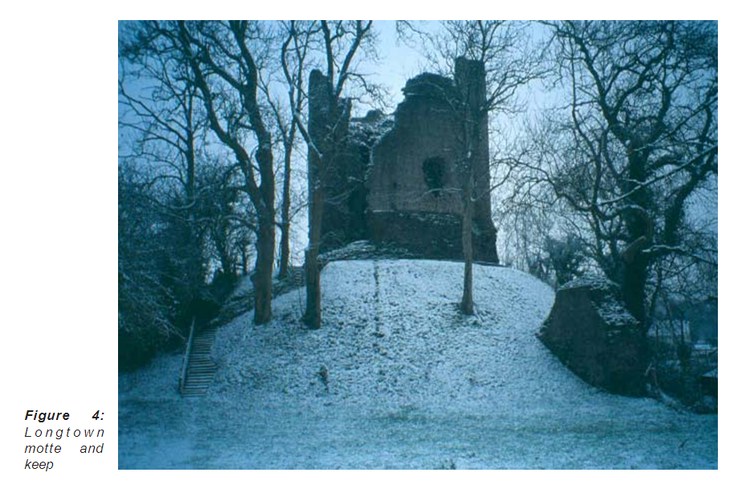
Figure 4: Longtown motte and keep
The earthwork remains surviving within the inner and outer baileys are few. The cross-wall, and its collapsed masonry, cuts across a generally scooped ground profile within the combined baileys, the ground rising gradually, but significantly, around the sides of the enclosures. Other features noted within these baileys were piles of rubble (Figure 3, w) immediately south of the cross wall. A building platform and footings (Figure 3, x) to the south-east of the inner bailey gateway appears to be the site of a house depicted on early maps (eg Figure
ENGLISH HERITAGE Longtown 16
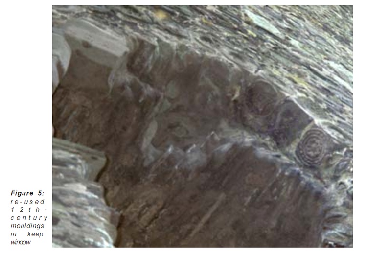
Figure 5: re-used 12th - century mouldings in keep window
2). A small section of wall from the footings of this building survives. The structure may be the remains of a castle building, or perhaps the ancient house used for meetings of the manorial court of Ewias Lacy after the castle was disused and leased out (above p9). It is, however, clearly of a different phase to the curtain wall joining its southern face. This has been re-used as the wall of a lean-to cottage or farm building (Figure 3, y) which was attached to its outer face. The southern and western walls of its yard delimit a platform, levelled when it was cleared of builders’ rubble in 1995 (Appleton-Fox 1995). This building appears to have been short-lived. It was depicted on only a map of 1904 (Ordnance Survey), although its yard walls already existed by the time of the first large scale detailed survey of the area (Ordnance Survey 1888). Further features are visible on the eastern side of both the inner and outer baileys (Figure 3, q). These appear on the ground as shallow linear undulations associated with parch marks, suggesting that wall footings lie just beneath the ground surface. Given the depth of overburden which has accumulated over the medieval deposits in the baileys (above p12), it is likely that these features are the remains of later farm buildings. Within the ‘eastern bailey’ there are at least three small building platforms (Figure 3, h & j). Their date is uncertain, but judging by their appearance and the fact that no buildings are featured here on 18th- and 19th-century maps, they are likely to be of an early period and could well be medieval. The eastern bailey has the same scooping of the centre seen in the inner and outer baileys, while a series of amorphous mounds (Figure 3, z) beside the road are probably spoil from road construction. A large sub-rectangular platform defined by a scarp 1m high has been overlain by one of these spoil heaps, as
has the small building platform (Figure 3, j) on its northern side.
ENGLISH HERITAGE Longtown 17
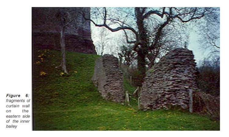
Figure 6: fragments of curtain wall on the eastern side of the inner bailey
6.3 The borough
The earthworks of the medieval borough can be seen in many parts of the present village and its surrounding fields. Adjoining the south of the castle is a sub-rectangular enclosure (Figure 8, a) mirroring that of the castle’s earthwork enclosure. It is defined by a scarp still standing to over 1m in height for most of its southern side, and 1.5m high on its eastern side, with shallower scarps and banks forming its western side. It is usually regarded as a defensive enclosure around the medieval borough (eg Buteux 1996, 5). Within it lies the core of the medieval town, now largely built over by later houses and their gardens. The church stands in a prominent position upon an area of raised ground immediately outside the old entrance to the castle and at the head of the former market place to its south. Much of the market place has been encroached upon, creating two narrow roads running parallel with each other. The western of these roads leads towards the church, which lies across it in front of the castle entrance, while the eastern road by-passes the masonry castle but cuts through the sub-square earthwork enclosure.
The main road through Longtown appears to have shifted to its present eastern alignment later, probably when St Peter’s Church was built across it - in a very good central location to the castle gate and the market place. It is evident, from the modern topography that the road was once much wider than it is now and has been encroached upon, creating long, thin plots of land alongside it. Medieval roads were unmade track ways which became wide as traffic meandered to avoid ruts and muddy patches. 15m wide was not unusual for a medieval street (Hindle 1990, 29), but that at Longtown would have been wider. In addition to the north-south streets, a further street runs at right angles. This leads to a perimeter road outside the western defences of the town and castle, and towards the former New Inn on its
eastern side, where it now terminates.
ENGLISH HERITAGE Longtown 18
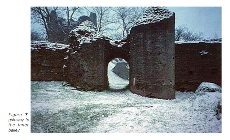
Figure 7: gateway to the inner bailey
The nature of the earthworks to the north of the castle has been the subject of much discussion. There is controversy as to whether an enclosure similar to the ‘burgus’ enclosure south of the castle also existed there. There is now no clear evidence of this enclosure on the ground. It is said to have relied on a steep slope for protection on the west, where there is now no evidence of a rampart (Buteux 1996, 5) but the slope here is not great and alone it would have hardly been adequate for defence. Despite this the broad bank (Figure 8, b) leading northwards from the castle is very similar to the earthworks of the enclosure to the south of the castle and it is plausible that it once formed part of a similar enclosure. There is no trace of any continuation of this, its eastern side, beyond modern housing at Pen Bailey, although later developments, including the housing at Pen Bailey and the re-sited Longtown Primary School are known to have destroyed earthworks in this area. There is further archaeological evidence to suggest that this area was once a part of the medieval borough. An evaluation and watching brief on land adjacent to the police station encountered construction and demolition levels, a sandstone wall and walls enclosing a flagged surface. These remains were associated with Monnow Ware dating from the 12th and 13th century, as well as18th century and later pottery (Taylor & Woodwiss 1988). The RCHM also recorded a slight platform or terrace in the north-western corner of the field to the north-east of the castle (RCHM 1931, 183) and later medieval pottery sherds were recovered from pits when construction of the new school took place in 1979. At the same time earthworks of tenement strips were observed (Ellis 1997, 72) and further house platforms were seen during a later watching brief (Buteux 1996, 6). The RCHME Upland Marches Project also recorded fragments of embanked rectilinear enclosures, possibly crofts of medieval settlement, to the north-east of the castle (NMR SO 32 NW 13), while records exist of tenement plots north of the castle between Jews Lane and main street (SMR 21942). Jews Lane probably formed the back lane to this north-western part of the medieval settlement, which may have expanded beyond this area since very scrappy earthworks to the north of Pen y Dre Farm
ENGLISH HERITAGE Longtown 19
Figure 8: Longtown Castle and borough, 1:2500 survey, English Heritage 2003 (Based on Ordnance Survey map sheets SO 3228 & SO 3229. Crown copyright reserved)
could be settlement remains. So, although a northern enclosure cannot be traced as an earthwork in anything like its entirety there is little doubt that the medieval borough extended into this area and that such an enclosure once existed.
The best settlement earthwork remains lie south of, and outside, the suggested borough defence enclosure. Two fields of well-defined earthworks were surveyed. The first of these fields lies to the south of the Outdoor Centre at SO 32312895. Here scarps and low banks define seven narrow, conjoined crofts, each of similar size and plan, leading back from the edge of a hollow-way which skirts the present road. A terminal bank just inside a modern hedge line, delimits their eastern extent. They are remarkably regular in size. At least four have building platforms (Figure 9, a) next to the hollow-way, while a modern rectangular enclosure (figure 9, b) is situated within one. The date of these building platforms and crofts is not known but there is no reason why they should not be medieval. They are not shown as buildings in the late 19th century (Ordnance Survey 1888) and since the settlement was called ‘Longtown’ by the 16th century, this shows that it had expanded along the road by that time. The regular layout of the earthworks would also be consistent with that of a planted town, where land was divided into long burgage plots at right angles to streets. The plots, occupied by burgesses paying a standard annual rent, usually 1/- a year, were of standard width, using the perch, rod or pole, usually 5m x 5m or 5m, as a unit of measurement (Hindle 1990, 52-4) .
The second field lies further south, in the V-junction opposite the Crown Inn, centred at SO 32602855. Here there is a further series of earthworks, this time less regular. They consist of low banks and scarps forming a system of enclosures between the road and a substantial lynchet (Figure 10, a) which forms their back scarp, at the junction between level ground on the ridge and ground sloping down to the River Monnow. Numerous small building platforms (Figure 10, b & d) are dotted irregularly amongst these enclosures. Despite the irregularity of the earthworks, traces of divisions of the type found in the field to the north may still be seen amongst the less regular features which probably result from later activity. Although the field is now under pasture the earthworks have seen several episodes of ploughing in the past. Narrow ridge and furrow cuts across them, running over the boundary lynchet and downhill into the valley. A field boundary, now a bank c0.5m high (Figure 10, c) was evidently in use to a later date since it demarcates the junction between two different alignments of narrow ridge and furrow. It also overlies the backscarp to the settlement, partly overlies a small building platform and a larger rectangular building platform. The field was under plough in 1946 (AP RAF 106G/UK 1652/July 1946 5178) and is known to have been the subject of land drainage in the 1970s. All the pottery visible in molehills during the English Heritage fieldwork was of 19th or 20th century date, but this may have been spread with manure since no buildings are shown on any early maps of the area. In c1840 the field is named
‘Pigeon House’ field (Tithe Award HRO 57/1-4), so one of the building platforms is almost certainly the site of a dovecote. Although dovecote buildings varied considerably in shape and size, descriptions of examples in Herefordshire (Stainburn 1979) indicate that they
were generally no more than 6m in length or diameter, so several of the small rectangular
ENGLISH HERITAGE Longtown 21
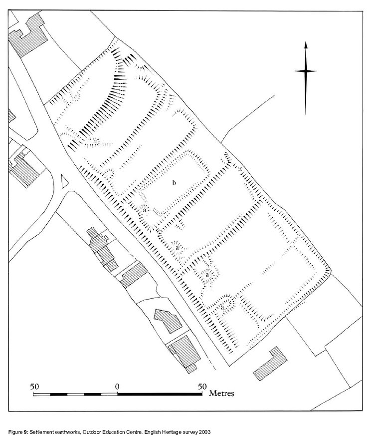
Figure 9: Settlement earthworks, Outdoor Education Centre. English Heritage survey 2003
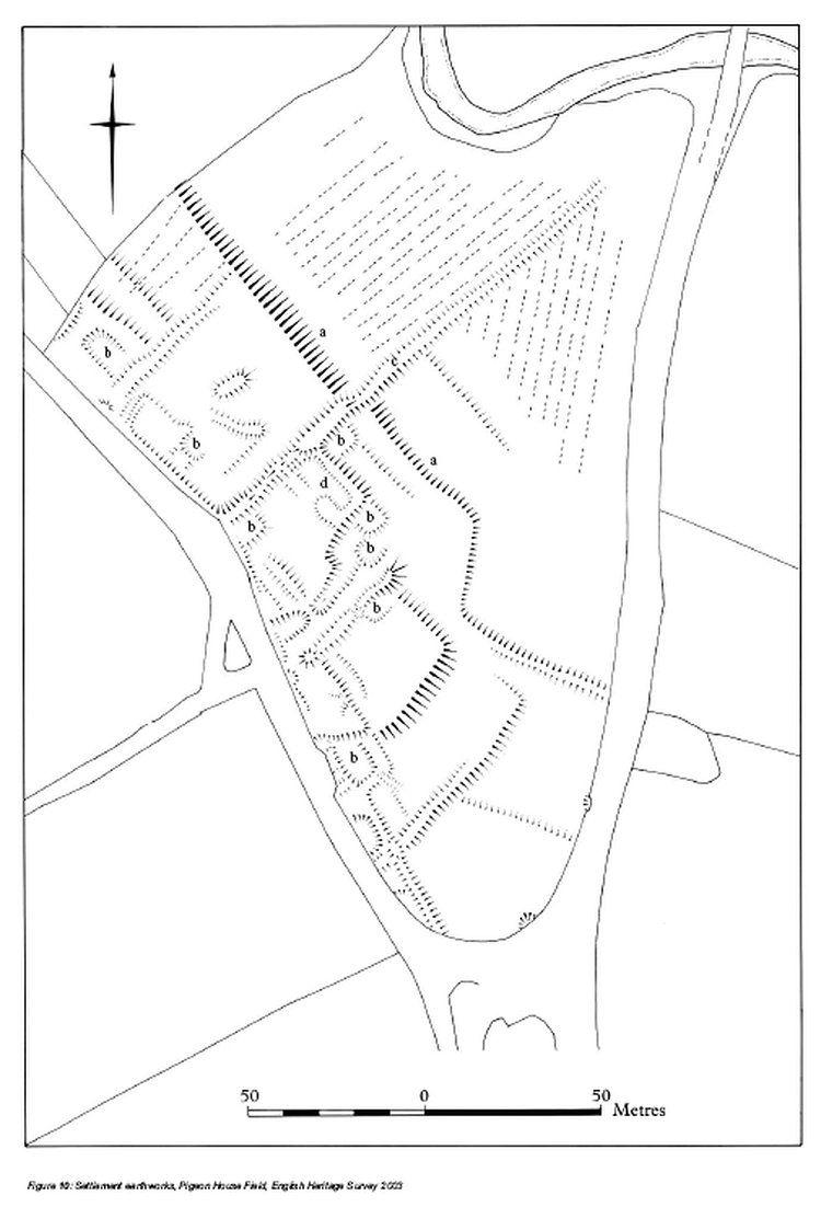
Figure 10: Settlement earthworks, Pigeon House Field, English Heritage Survey 2003
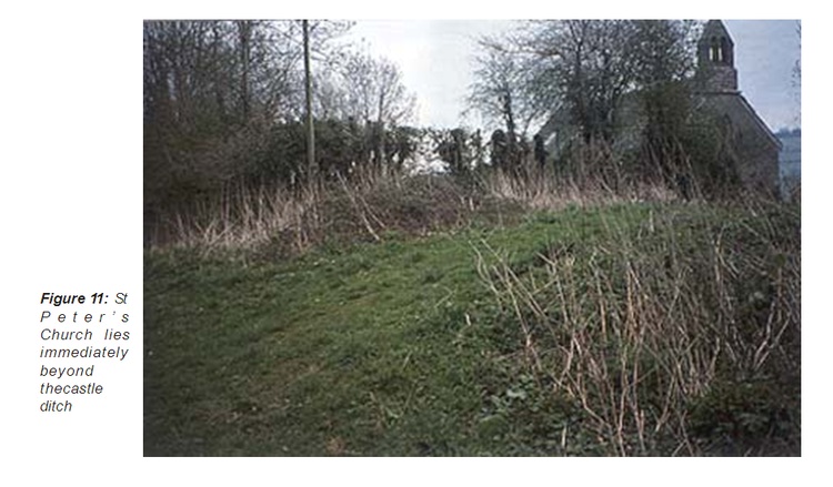
Figure 11: St Peter’s Church lies immediately beyond the castle ditch
building platforms are possible candidates. Even if the dovecote was of later date, it is likely to have been built by the 16th or early 17th centuries. Later dovecotes were usually built from brick and an octagonal plan was the most likely form (Stainburn 1979, 8), of which there is no trace on the ground today.
In 2000 an area measuring 60m x 90m in the north-western corner of the field was the subject of a geophysical survey by Herefordshire Archaeology. The survey recorded areas of high resistance associated with one building platform (Figure 10, d) and also found the field bank (Figure 10, c) to contain buried stone (Hoverd 2000).
Between the two fields surveyed there is a large field and two smaller paddocks. In each of these the earthworks of property boundaries similar to those surveyed to the north and south can be traced, but the settlement area now lies under a recent housing development along the main street. The full extent of earthworks prior to development can be seen on aerial photographs (eg Figure 12). The back scarp clearly continued north from Pigeon House Field and made a right angled turn towards the road. Beyond this there were four more long narrow crofts connecting the earthworks with those recorded in the Outdoor Education Centre field to the north. Herefordshire Sites and Monuments Record also records earthworks in the small field to the rear of the vicarage (SMR 19478). These were not surveyed by EH because access was not possible at the time of the survey, but at least one of the boundaries recorded to the north extended into the area now occupied by the Vicarage.
In the wider area around the village there is further evidence of arable cultivation. To the west of the main street no earthworks, except a block of narrow ridge and furrow centred at SO
32352870, were seen beyond the borough enclosure earthwork. The straight and narrow
ENGLISH HERITAGE Longtown 24
post-medieval ridge and furrow, known locally as “cop and reen” (pers comm Mr P Hope) can also be seen at SO 3243 2860 (SMR 9828). Further ridge and furrow in two fields at SO 32162857 has been mapped from aerial photographs (NMR SO 32 NW 49).
Earthwork remains of earlier field systems are also evident around Longtown. A series of lynchets lies on the hill-slopes between the Olchon Brook and the castle, while at least four banks perpendicular to these can be seen in fields immediately north-west of the castle. Several of the plot boundaries of the medieval borough are also delimited by disproportionately large scarps, which may have been re-used field lynchets, while the double bend in the road to Llanwonog suggests that it followed field boundaries. The general impression, echoed in the modern topography, is that the entire complex of castle and borough has been superimposed upon an earlier layout of pre-medieval fields.
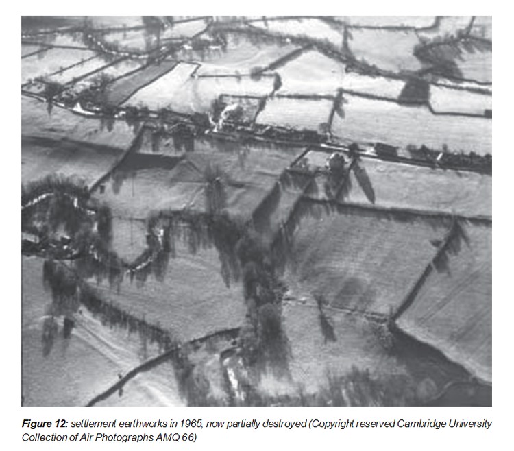
Figure 12: settlement earthworks in 1965, now partially destroyed (Copyright reserved Cambridge University
Collection of Air Photographs AMQ 66)
ENGLISH HERITAGE Longtown 25
7 DISCUSSION
7.1 Origins of the sub-square earthwork enclosure
There is little doubt, from the plan of the castle and the form of the earthworks, that the motte of Ewias Lacy Castle was built upon an earlier sub-square enclosure, which served as the bailey of the earthwork castle. The origins of this enclosure have continued to be a matter for speculation. Considered to be a Roman camp by early commentators (Duncumb 1812, 274; Robinson 1869, 119), later writers have taken a more cautious approach, stressing that beyond a general resemblance in plan to a Roman fort there is little archaeological evidence to support the theory (RCHM 1931, 183; Shoesmith 1996, 168). Roman remains reported to have been found when the school was built within the eastern bailey in 1869 (Kelly’s Directory of 1895) would have helped to confirm the theory, but the report does not specify what the remains were, and they cannot be traced in any local museums today. The re-use of earlier earthworks for Norman castles was a common practice and there are numerous examples (eg see Platt 1982, 4). Given a likely 12th-century date (see above p7) for the construction of the motte at Ewias Lacy, this gives a wide possible date range of prehistoric, Roman, Anglo- Saxon, or the earlier medieval period for the enclosure. The Ordnance Survey Archaeological Investigator, Alan Phillips, thought that it was Iron Age in date, from its siting and the large size of its ramparts (NMR SO 32 NW 1). The siting evidence is good and there is a class of small univallate enclosures, some of which are known to be of early Iron Age date, however, they are generally smaller than the enclosure at Longtown (Olding 2000, 67; RCAHMW1986). The size of the ramparts is also not necessarily indicative of the age of the enclosure, since the earthworks show evidence of rebuilding - seen in numerous breaks in slope and in the presence of small banks on top of a more spread earthwork.
Comparable sites are equally problematic. Mathrafal Castle, Powys also has a sub-rectangular bailey enclosure, overlain in one corner by its motte, and this was once thought to have been of Roman date. It was later re-interpreted as of Dark Age origin and subsequently as no earlier than the 13th century, although Roman finds have been reported from the site (Clwyd Powys SMR 69 & 50453). Painscastle Castle, built by Pain Fitz John is also similar in many ways to Longtown Castle. Its motte also overlies a sub-rectangular bailey with rounded corners which may once have been a Roman fort. Here Roman pavements found at the site support the hypothesis (Remfry 1996).
The Roman fort theory is plausible. Roman forts existed at Gobannium and Clyro. Longtown lies midway between them, and is a normal day’s march from each, although the course of Roman roads in the area is not certain and an alternative route could have been through the Golden Valley (Margary 1973, 343). A small auxiliary fort such as Coed-y-Caerau (Nash- Williams 1969, 150) is of a size consistent with that at Longtown. The enclosure’s general
ENGLISH HERITAGE Longtown 26
plan also bears a resemblance to an auxiliary fort, as does its siting on a ridge close to the junction of two river valleys (Nash-Williams 1969, 146). Tomen y Mur fort also covers a comparable area to the Longtown enclosure, being only 1.3ha. Another possible parallel would be a Romano-British domestic enclosure such as those at Whitton, South Glamorgan or Grambla, Cornwall (see Hingley 1989, 62-3).
It has been argued more recently that the enclosure may be the last Saxon burh built, according to Florence of Worcester, by Earl Harold Godwinson beyond the Golden Valley during his Welsh campaign of 1055-6 (Remfry 1997, 31). The Lower enclosure at Carisbrooke Castle, Isle of Wight, has similarly been interpreted as a Saxon burh (Young 1983). As far as the burhs of Wessex are concerned, apart from a handful of well-known examples, which are far larger than the enclosure at Longtown, they were not generally square in plan (Hill & Rumble 1996, 189; Hadrian Allcroft 1908, 392; Braun 1936, 11). However, the last generation of 10th century Mercian burhs took a different form. They were fortified enclosures for the containment of garrisons, built to dominate areas and control communication routes rather than enclosing the population in the manner of Alfredian burhs (Creighton 2002, 137). A wide berm between bank and ditch was a feature the later Mercian burhs shared with those of Wessex (Biddle 1976, 135). This is lacking at Longtown but we have already noted that the ramparts have been modified during later periods. If the enclosure does represent the remains of this Saxon burh it would have remained stranded within Welsh territory for over a hundred years since the Saxons failed to advance into central Ewias.
7.2 The masonry remains
That the earthwork castle of Ewias Lacy was strengthened by the addition of a substantial keep and a stone curtain wall around the western half of the original bailey, probably during the early 13th century, is probable. The fragments of masonry standing now have always been regarded as part of this original fabric, but dating of stonework is by no means precise. There is little problem with the keep. The fragments of curtain wall running down the eastern side of the inner bailey are also likely to be part of the castle’s earliest stone fabric, albeit preserved by their incorporation into later buildings. The cross-wall between the inner and outer baileys, however, seems remarkably well preserved when compared with the rest of the castle and must have at least been maintained into a later period. It was not built upon the line of an earthwork, but rather overlies the scooped profile of the baileys, so field evidence suggests that it was a later addition. It could have been constructed before the death of Bartholomew de Berghersh’s son in 1369, as part of 14th-century change, when lords moved away from great halls to separate apartments and sought greater privacy, because after this date there is unlikely to have been a resident lord at Longtown. Recent work has suggested that entry to castles was graded carefully according to social status and where a castle has an upper and lower court entry through the gatehouse between them implies social as well as physical progress (Johnson 2002, 71-72). The small size of the gateway may have thus been a deliberate feature to restrict access to the inner bailey. By the early 18th century the cross-wall formed a boundary between a garden and a yard
ENGLISH HERITAGE Longtown 27
(Fellowes 1718), so the gateway may then have had a decorative purpose as part of the later garden.
An ‘aunchient house’ used for the manorial court stood at Longtown Castle in the 17th century (Gwent County Record Office D1583.2.12) and was still being used in 1732 (Gwent County Record Office D 1583.3.11). This could have been the house depicted on a map dating from the early 18th century as standing immediately south-east of the inner gateway with the outer bailey forming its garden (Fellowes 1718). It was demolished sometime between 1887 and 1904 (Ordnance Survey 1888 and 1904). Two buildings attached to its southern wall were short-lived, being depicted on a plan of 1800 only (Gwent County Record Office D1583.187).
7.3 The development of the settlement
As the foci of smaller Marcher baronies, castle boroughs were important tools of colonisation in the border zone long after much of lowland England had been pacified (Creighton 2002, 170) and the settlement at Longtown thus forms part of a wider pattern of borough creation (eg Brown 2000). Founding a new town was also profitable for lords because the burgage rents, tolls from outsiders to use the market and rents for market stalls all provided income. Early phases of settlement growth outside castles often took place within embanked precincts appended physically to the seignurial site - often called ‘burgus’ settlements (Creighton 2002, 159). In a few instances the borough was located inside the castle bailey, but it was generally close by. Its plan usually consisted of a broad street stretching away from the castle gate, wide enough for a market place and bordered by burgage plots leading back to the edge of a surrounding field (Pounds 1990, 218). Aspects of this layout can be seen in the earthworks and topography of Longtown, but there are still questions to be answered not only about the size and extent of the medieval borough, but also about its development and the nature of its defences. Both earthwork and excavated evidence has indicated that during its heyday in the 13th century the borough extended to the north of the castle and earthwork evidence further shows possible settlement within the eastern bailey. Straggling along the eastern side of the road, south of the borough’s core and beyond the earthwork believed to represent its defensive boundary are more settlement earthworks, but nothing is to be seen to the west of the road. It is not certain whether this is because there was never any settlement there or whether its remains have been destroyed. If the figure of 100 burgesses recorded in 1310 is at all accurate, this number could not have been located within the burgus enclosure alone, so the town must have covered a larger area by that date. The settlement remains to the south may represent later expansion, while the probable enclosure to the north of the castle may have been a further burgus defence. The large number of burgesses recorded coincides with the period of peace in the early 14th century (above p8), when an undefended, and perhaps short-lived, extra mural suburb may have been added.
ENGLISH HERITAGE Longtown 28
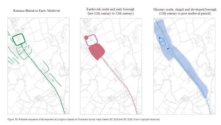
Figure 13: Probable sequence of development at Longtown (based on Ordnance Survey maps sheets SO 3228 and SO 3229. Crown copyright reserved)
From the earthwork plan it could be argued that the enclosure adjoining the southern boundary of the castle was a southern bailey of the castle, with the chapel inside it, rather than a ‘burgus’ enclosure. Alternatively a southern bailey could have been abandoned and the medieval town laid out within it. It may even be proposed that a southern bailey was constructed over part of the medieval borough as at Ludgershall, Wiltshire (Ellis 2000, 111-113). This does not, however, seem likely. There is no historical context for such an expansion of the castle, which would also have cut the medieval settlement in two. The market place also lies within the enclosure, indicating that the enclosure was indeed part of the settlement.
The relationship between the settlements of Longtown (Ewias Lacy), Clodock and Pont Hendre is interesting. These villages and farms cluster together along a 1 mile stretch of the Hay to Abergavenny road, which is remarkably close in this area of widely dispersed settlement. It has already been suggested (above p5) that Clodock was the early focus for settlement and that the borough at Ewias Lacy was relatively late, being founded sometime before 1232 (above p9). We do not know whether a settlement had already developed prior to the borough’s foundation, but it is a distinct possibility that the castle had attracted extra-mural activity and there could have been rivalry between the two settlements. There is a further hamlet close to the crossing of the Olchon Brook and the motte and bailey castle at Pont Hendre. This has foci at Middle Pont Hendre and Upper Pont Hendre. There is now no indication of a ‘Lower Pont Hendre’, but Upper Pont Hendre today appears almost contiguous with the southern extent of Longtown.
ENGLISH HERITAGE Longtown 30
8 METHOD OF SURVEY
The field investigation was carried out by Nicky Smith and David Field. The castle was surveyed using a Trimble 5600 Total Station Theodolite. Survey control and topographical detail in Pigeon House Field and the Outdoor Education Centre Field was established with a Trimble 5700 Global Positioning System (GPS) and archaeological detail measured using taped offsets. The survey data was processed with Geosite Office and Trimble Geomatics software.
Longtown proved particularly difficult in terms of access to some areas. Access was denied land immediately east and north-east of the castle, which included the eastern side of the castle ditch. The plan detail in these areas is based upon previous surveys.
The inked plans and CAD artwork were produced by Deborah Cunliffe. Site photography is by Nicky Smith. This report was researched and written by Nicky Smith and edited by Mark Bowden. The project archive has been deposited in English Heritage’s National Monuments
Record, Great Western Village, Kemble Drive, Swindon SN2 2GZ, where it may be consulted.
9 ACKNOWLEDGEMENTS
English Heritage would like to thank Mrs Brierley, Mr & Mrs Hope, Mr Rogers, the Longtown Commoners, Mrs Faulder, Mr Burson and the Outdoor Education Centre, all of whom permitted access to their land. Rachael Rogers of Abergavenny Museum, Nina Hely- Hutchinson of Hereford County Museum and Evan Chapman of the National Museum of Wales supplied details of archaeological finds from Longtown. Jeff Spencer of the Clwyd Powys Archaeological Trust kindly provided information on Mathrafal Castle. I would also like to thank David Field for commenting on the draft of this report and for engaging in helpful discussion about the site.
ENGLISH HERITAGE Longtown 31
LIST OF REFERENCES
Appleton-Fox N 1995, Longtown Castle: A Watching Brief on Remedial Works, January
1995, Hereford Archaeology Series 234 (City of Hereford Archaeology Unit: Hereford) Bartlett A 1984, Geophysical Survey at Longtown, AM Lab Report 5/84 (English Heritage) Beresford M 1988, New Towns of the Middle Ages (Lutterworth Press: London)
Beresford M & Finberg H 1973, English Medieval Boroughs: A Handlist (David & Charles: Newton Abbot)
Biddle M 1976, Towns The Archaeology of Anglo-Saxon England, ed D Wilson, 99-150 (Methuen & Co: London)
Braun H 1936, The English Castle (Batsford: London)
Brown G 2000, Richard’s Castle, Herefordshire English Heritage Survey Report
Buteux V 1996, Archaeological Assessment of Longtown, Hereford and Worcester. The Central Marches Historic Towns Survey (Hereford & Worcester County Council: Worcester)
Butler L 1976, The Evolution of Towns: Planned Towns after 1066, ed M Barley Town
Defences in England and Wales after 1066, CBA Research Report 14, 32-48
Cathcart King D 1972, The Field Archaeology of Mottes in England and Wales, Chateau
Gaillard V, 107-110
Cathcart King D 1988, The Castle in England and Wales: An Interpretative History
(Croom Helm: London)
Coplestone-Crow B 1989, Herefordshire Place-names, British Archaeological Report 214
Creighton O 2002, Castles and Landscapes (Continuum: London)
Duncumb J 1812, Collections Towards the History and Antiquities of the County of
Hereford 2, part 1(E Wright: Hereford)
Edwards R 1989, Record of Watching Brief by Hereford and Worcester County Council
(SMR 22006)
ENGLISH HERITAGE Longtown i
Ellis P 1997, Longtown Castle: A Report on Excavations by J Nicholls 1978, Trans
Woolhope Naturalists Field Club XLIV pt I, 64-84
Ellis P ed 2000, Ludgershall Castle. Excavations by Peter Addyman 1964-1972 Wiltshire
Archaeological and Natural History Society Monograph Series 2 (WANHS: Devizes)
Fellowes B 1718, Right Honourable Henry, Earl of Abergavenny: His Lordship’s Large Map Book Containing Plans of Several Farms in the Counties of Monmouth and Hereford, reduction by D Davies 1806 (British Library MAN A/2/270)
Fleming T, Longtown Castle, Longtown, Herefordshire: Draft Conservation Statement
(undated report for EH)
Gwent County Record Office, lease of 24 November 1692 (D1583.2.12) Gwent County Record Office, lease of 24 June 1732 (D1583.3.11)
Gwent County Record Office c1800, Survey of the Estate of the Right Honourable Earl of
Abergavenny in the Hundred of Ewias Lacy (D1583.187)
Hadrian Allcroft A 1908, Earthwork of England (Macmillan & Co: London) Harnden J 1984, The Hearth Tax Assessment of Michelmas 1665 (typescript in Herefordshire County Record Office)
Hill D & Rumble A (eds) 1996, The Defence of Wessex: The Burghal Hidage and Anglo- Saxon Fortifications (University Press: Manchester)
Hindle B 1990, Medieval Town Plans (Shire: Princes Risborough)
Hingley R 1989, Rural Settlement in Roman Britain (BA Seaby: London)
Houston J 1999, Olchon Development Project, Local History Report and Field Name
Survey (Typescript, Herefordshire County Record Office)
Hoverd T 2000, A Geophysical Survey at Longtown, Herefordshire Archaeology Report 16
Jeffreys W c1800, Survey of the Estate of the Right Honourable the Earl of Abergavenny in the Hundred of Ewias Lacy (Gwent County Record Office D1583 187)
Johnson M 2002, Behind the Castle Gate from Medieval to Renaissance (Routledge: London)
ENGLISH HERITAGE Longtown ii
Kay R 1978, Longtown Castle Herefordshire Archaeological News 35, June, 8-10 (Woolhope Club Archaeological Research Section: Hereford)
Kenyon J 1990, Medieval Fortifications (University Press: Leicester)
Kenyon J 1996, Fluctuating Frontiers: Normano-Welsh Castle Warfare c1075-1240
Chateau Gaillard XVII, 119-26
Margary I 1973, Roman Roads in Britain (John Baker: London)
Marshall G 1932, Report on the Discovery of Two Bronze Age Cists in the Olchon Valley, Herefordshire Trans Woolhope Naturalists Field Club 27, 147-153
Marshall G 1938, The Norman Occupation of the Lands in the Golden Valley, Ewyas, and
Clifford and their Motte and Bailey Castles Trans Woolhope Naturalists Field Club 29,
141-158
McNeill T 1992, Castles (English Heritage & Batsford: London)
Morriss R & Williams R May 1991, Notes on the History of Longtown, or Ewias Lacy, and the Structural Development of its Castle, Hereford Archaeology Series 104 (City of Hereford Archaeology Unit: Hereford)
Nash-Williams V 1969, The Roman Frontier in Wales 2nd edition ed M Jarrett (University of Wales Press: Cardiff)
Noble F 1964, Medieval Boroughs of West Herefordshire Trans Woolhope Naturalists Field Club 38, 62-70
O’Donnell J 1971, Market Centres in Herefordshire 1200-1400 Trans Woolhope Naturalists Field Club 40, 186-94
Olding F 2000, The Prehistoric Landscapes of the Eastern Black Mountains, BAR British Series 297
Ordnance Survey 1888, 25" County Series 1st Edition, Herefordshire Sheet XLIII:12
Ordnance Survey 1904, 25" County Series, Herefordshire
Page W (ed) 1908, Victoria County History of Herefordshire, vol I (Archibald Constable & Co: London)
Perry R 2002, Anglo-Saxon Herefordshire (Oxengard Press: Gloucester)
ENGLISH HERITAGE Longtown iii
Platt C 1982, The Castle in Medieval England and Wales (Secker & Warburg: London)
Pounds N 1990, The Medieval Castle in England and Wales: A Social and Political
History (University Press: Cambridge)
Remfry P 1996, Castles of Radnorshire (Logaston Press: Woonton Almeley) Remfry P 1997, Longtown Castle 1048-1241 (SCS Publishing: Worcester)
Remfry P 1998, The Castles of Ewias Lacy 1048-1403 (SCS Publishing: Worcester)
Robinson J 1869, A History of the Castles of Herefordshire and their Lords, 2002 ed R Charles (Logaston Press: Woonton Almeley)
Royal Commission on the Ancient and Historical Monuments of Wales 1986, Brecknock
part ii (HMSO: London)
Royal Commission on Historical Monuments (England) 1931, An Inventory of the
Historical Monuments in Herefordshire, I: South-West (HMSO: London)
Royal Commission on Historical Monuments (England) 1934, An Inventory of the
Historical Monuments in Herefordshire, III: North-West (HMSO: London)
Salter M 1989, The Castles of Herefordshire & Worcestershire (Folly Publications: Wolverhampton)
Salter M 2001, The Castles of Mid Wales (Folly Publications: Wolverhampton)
Shoesmith R 1996, Castles and Moated Sites of Herefordshire (Logaston Press: Woonton Almley)
Soil Survey 1983, Soil Map of England and Wales, Sheet 5
Stainburn I 1979, Dovecotes and Pigeon Lofts in Herefordshire (Planning Dept, Hereford
& Worcester County Council: Worcester)
Stone R 1997, Evaluation Excavation, Central Kitchens Industrial Estate, Marches
Archaeology Report 011
Taylor G & Woodwiss S 1988, Evaluation Excavation at Land Adjacent to the Police
Station, Longtown (Hereford & Worcester County Council Archaeology Section)
Thompson M 1987, The Decline of the Castle (University Press: Cambridge)
ENGLISH HERITAGE Longtown iv
Watkins A 1932, Cannon-Ball from Longtown Castle Trans Woolhope Naturalists Field
Club 27, 186-7
Young C 1983, The Lower Enclosure at Carisbrooke Castle, Isle of Wight Rome and her
Northern Provinces ed B Hartley & J Wacher, 290-301 (Alan Sutton: Gloucester)
ENGLISH HERITAGE Longtown v
Ref: rs_lon_0245