
Held at: | Hereford Public Library |
Reference: | Local Collection |
Source: | Transactions of the Woolhope Naturalist’ Field Club, 1938 |
Title: | Guest Contribution: The Norman Occupation in the Golden Valley, Ewyas and Clifford: Paper by George Marshall |
Place name: | Golden Valley, Ewyas |
Date: | Norman period |
Description:
George Marshall JP FSA 1859-1950, was a prominent member of the Woolhope Club. He was the Hon Secretary for 29 years and President of the Club in 1922 and 1940. He contributed many articles to the Transactions. His paper on the Norman occupation of the Golden Valley and the Lands of Ewyas is as valuable today as when it was written over 70 years ago; it is reproduced below.
THE NORMAN OCCUPATION OF THE LANDS IN THE
GOLDEN VALLEY, EWYAS, AND CLIFFORD AND THEIR
MOTTE AND BAILEY CASTLES.
By George Marshall, F.S.A.
(Read 28th June, 1938.)
Before dealing with the advent of the Normans to the district under review, a short survey of the conditions prevailing there previous to that period will be helpful to an understanding of the Norman occupation.
The natives of this region at the coming of the Romans must have been Late Bronze Age men with an infiltration of the Early Iron Age race who, through the researches of our member, Mr. R. S. Gavin Robinson, have been located as living on the high ridges which are such a conspicuous feature of this area of deep valleys and lofty hills.
Now, though the Romans penetrated the district and drove roads through it, their culture made little impression on the native inhabitants, except to the extent that during the ordered rule of Rome there was an increase in their numbers and that they were encouraged to descend from the hills and bring into cultivation the richer lands of the valleys.
The spread of Christianity in Wales under the British Church had reached this remote spot by the end of the 6th century, for in the Liber Landavensis mention is there made of Clodock and other churches in the district. It is also recorded[1] that in the time of Teithfallt and Ithael, kings of Wales (c. A.D. 570-600), great tribulations and plunderings were committed by the most treacherous Saxon nation, and principally on the borders of Wales and England towards Hereford, so that all the border country of Wales was nearly destroyed, and especially about the river Wye. After a time peace was established, the land was restored to its owners and its former authority, although destroyed and depopulated by foreign people and an uncommon pestilence[2] . In another entry it is described as 'plundering and laying waste by the Saxons', especially on the borders of the diocese from Mochros (Moccas) on the banks of the Wye, on one part as far as the river Dore, and on the other as far as Gurmuy (the Worm) and to the mouth of Taratyr (the Tarr) at the river Wye[3]
After this inroad of the Saxons the boundary of the diocese of Llandaff, so far as the Herefordshire border is concerned, is stated to have been by way of the pass Bwlch-y-Fingul at the head of the Llanthony valley, to the source of the Nant-y-Bar brook, down this brook to the Dore, along the Dore to the influx of the Worm, and up the Worm to its source, and then by Caer rein (Aconbury) to the source of the Taratyr (Tarr), thence along it to its influx into the Wye, down the Wye, etc.[4]
These accounts point to the latter part of the sixth century, as the time when the Saxons pushed across the Wye and occupied the land between that river and the Dore, territory which up to that period had been ruled by the Welsh. Whether this account of the boundaries can be relied upon for the date attributed to it may be questioned, as the monastery of St. Teilo at Llandaff and the British Church in general had not at that time defined territorial boundaries, but it undoubtedly indicates the boundary claimed by the See of Llandaff at the time the Liber Landavensis was compiled, for the same boundaries are set out in a Bull[5] of Pope Honorarius II, dated 1129, and might well have been laid down several centuries earlier.
The lengthy dispute, which led to the compilation of the Liber Landavensis to prove the claims of Llandaff against St. David's and Hereford dioceses, was at last settled in 1132. Llandaff lost its case, for all the churches and chapels in Ewyas Lacy were assigned to St. David's, and the churches of Bacton and Turnastone (St. Leonards) on the right bank of the Dore, and Peterchurch on the left bank, over which there was also dispute though outside the boundary claimed by Llandaff, were confirmed to Hereford diocese[6] , which probably had exercised rights over these three parishes from the coming of the Normans if not earlier. So the boundaries remained until 1852, when all the parishes in Herefordshire belonging to St. David's were transferred to Hereford diocese.
Before the Norman Conquest the Saxons had undoubtedly advanced beyond the river Dore and occupied lands in Bacton, Turnastone and Peterchurch probably as far as what was afterwards the boundary of Ewyas Lacy lordship, as will be seen later. A study of Domesday Book supports this surmise, for it will be found there that the lands held by Saxons were reckoned in hides, whereas the Welsh areas are recorded in carucates.
A summary of what took place on this border during the generation previous to the year 1066 is a necessary prelude to a study of the events that took place after that date. These subsequent developments are to be gathered mainly from that invaluable document the Domesday Survey.
King Edward the Confessor, who reigned over England from 1042 to 1066, was bred up in the Norman Court in France, and brought over to this country many Frenchmen. Edward, who was weak in character, had married the daughter of Earl Godwin, who became the virtual ruler of the kingdom until his death in 1053.
At Edward's accession Earl Godwin severed Herefordshire with its Welsh dependencies of Archenfield and Ewyas from Leofric's Earldom of Mercia, and created a new Earldom of Hereford, which he gave to his son Sweyn, who in 1046 on account of his lawless behaviour was banished from the kingdom. The King took this opportunity to give the Earldom of Hereford to his nephew Ralph, son of his sister Goda. The new Earl was opposed to everything English and brought in his train to Hereford many Frenchmen. Two of these Frenchmen, Osbern, surnamed Pentecost, and Richard Fitz Scrob were intimately connected with our border history. These two men received from Earl Ralph grants of lands on the Herefordshire border, the former at Ewyas Harold and the latter at Richard's Castle. With Richard Fitz Scrob's territory in the north of the county it is not proposed to deal, but Osbern's land at Ewyas Harold falls within the area being dealt with, and during the Norman period was one of the most important posts on the Welsh border.
On taking possession of their new property both these men proceeded to build themselves castles on the pattern of those they were accustomed to in their native Normandy, that is of the motte and bailey type. So here in Herefordshire we still have existing the remains of two castles, the first of their kind in the kingdom, which after the Conquest in 1066 were to become such a feature on this borderland.
The erection of such buildings was quite foreign to the customs and traditions of both Saxons and Welshmen alike, who lived in communities with their chiefs dwelling amongst them as one of themselves, so that when these foreign overlords shut themselves up in impregnable fortresses, and from these strongholds committed many acts of oppression, the anger of the natives was aroused and the first opportunity taken, to turn upon their new masters.
Such opportunity was not long delayed, for in 1051 Sweyn, through the influence of his father Earl Godwin, returned to England and was re-instated in his Earldom of Hereford. But the men of Herefordshire, though hating the Frenchmen, hated Sweyn still more, and supported as they were by Leofric, Earl of Mercia, and Siward, Earl of Northumbria, joined forces with the Frenchmen in opposition to Earl Godwin and his son Sweyn. Godwin had marched to Gloucester in support of his son, but seeing the unexpected forces ranged against him he beat a tactful retreat and fled to Flanders.
In the following year, 1052, the Welsh, taking advantage of the absence of the now re-installed Ralph as Earl of Hereford, invaded Herefordshire and defeated the Saxons and Frenchmen, who failed to work together. Earl Godwin took advantage of this critical time to return to England, whereupon the French favourites fled the kingdom and Osbern Pentecost and his retainers escaped to Scotland not to return. His castle of Ewyas Harold, or as it was then known Pentecost castle, was dismantled. Ralph, however, retained his Earldom of Hereford.
In 1053 Godwin died and was succeeded in his Earldom by his son Harold, who eventually succeeded Edward the Confessor on the throne, and was slain shortly after at the Battle of Hastings.
In 1055 Gruffydd, Prince of North Wales, descended upon Herefordshire and, marching through Ewyas and Archenfield, laid the country waste and sacked the city of Hereford. Whereupon Earl Harold was sent to Hereford and after re-fortifying the city[7] set out to punish the Welsh marauders, who retreated into Wales. After this the district of Ewyas would seem to have had peace until the advent of William the Conqueror in 1066, for there is no evidence that the Welsh raids in 1062 took place in this district.
When Ralph, Earl of Hereford, died in 1057, he left a son Harold, a child about five years old, and it was he who eventually became possessor of and gave his name to Ewyas Harold.
A long time before the Norman Conquest the country had been divided into Hundreds for the purpose of judicial, military, and fiscal administration. The Herefordshire Hundreds at the time of the Survey were composed of manors detached and scattered over the county, but about the year 1125 they were re-constituted in compact blocks and so they have remained to the present day.
The Saxon Thane or in post-conquest times the manorial lord was responsible to the Hundred Court, and the Hundred Court to the Shire Court presided over by the Sheriff (Shire-reeve), and the Sheriff to the King. The actual working of this administration was altered but little on the accession of William the first to the throne, except by the introduction of the feudal system, by which the tenants-in-chief, namely those men who had the land granted to them at the Conquest, held their property directly from the King by knight's service. By this arrangement the tenants-in-chief were bound to find a knight or knights with certain retainers all fully armed to do military service when and where required for forty days, or some service military or otherwise for the King.
The tenants-in-chief to ensure being able to produce the necessary number of knights when summoned to do so, sublet parts of their lands to individuals who became responsible to their overlord for one knight or more according to their agreement with him. This was known as subinfeudation. In course of time this knight's service was compounded for a monetary payment, it being found that mercenaries were more reliable, as the time limit of forty days would not apply to them.
The district now being dealt with was divided between seven tenants-in-chief, and a small portion was retained in the King's hands. Ewyas Harold was held by Alured de Marlborough; Ewyas Lacy by Roger de Lacy; Poston by William de Scohies; Peterchurch by Hugh L'Asne ; Dorstone by Durand of Gloucester ; Middlewood, Bach and Harewood, for the most part in Clifford parish, by Gilbert son of Thurold; Clifford Castle by Ralph de Todeni; and part of Cusop by the King.
Of these eight holdings two were important Castleries (Castellaria), namely Ewyas Harold and Clifford; Snodhill (in Peterchurch) became an Honour to which a number of manors scattered in other Hundreds did service; the large territory comprising Ewyas Lacy manor and adjoining lands was subject to Ewyas Lacy Castle, now known as Longtown Castle; Dorstone was the headquarters of its lord; and Poston was a manor belonging to a lord who resided elsewhere.
On these feudal holdings the owners on taking possession erected a castle of the motte and bailey type, familiar to them in their native Normandy, and a necessary precaution to enable them to hold their newly acquired property. Such a stronghold was more especially required where the population was composed of the Welsh race, who up to this time had not come under the Saxon rule. It is therefore in the Welsh area that these castles are found to be most numerous.
In addition to the lord's motte others were erected by his knights as definite areas of land were assigned to them in the process of subinfeudation, though it would appear probable that many of these had not been built until a date subsequent to the Domesday Survey, as may be inferred from the entry there concerning Ewyas Harold, where the knights held land in the lord's demesne.
This type of fortified residence consisted of a lofty mound of earth with steep sides surrounded by a fosse or deep ditch filled if possible with water, to which was attached an enclosed area known as the bailey, also surrounded by a ditch and earthen embankment which linked up with the fosse of the motte on either side. Both the motte and the bailey varied in size according to the importance of the holder, and the number of his retainers, and the quantity of stock he had to accommodate. The motte was protected round its upper edge by a palisade of wood with a wooden tower in the centre in which were the living quarters of the lord.
This tower was approached by a wooden bridge across the fosse, and the summit of the mound was reached by a ladder, both of which could be removed wholly or in part if necessity arose. The bailey on its inner rim would have had a strong fence or palisade, and inside sheds for the accommodation of the retainers, and pounds for the horses, cattle, sheep, pigs and other domestic livestock.
It was not until a much later period that palisades were replaced by stone walls, timber for the outer defence works, or even thorn fences being still used in some of the greater castles as late as the end of the thirteenth century. Many of the small mottes and baileys never had other than wooden defence works.
Commencing at the south of our area mottes are to be found at Llancillo, Walterstone, Rowlstone, Lower Pont Hendre in Clodock, Longtown, Ewyas Harold, New Court in Bacton, Cothill in Turnastone, Snodhill in Peterchurch, Dorstone (castle), Mynydd Brith in Dorstone, Nant-y-bar in Dorstone, Mouse Castle in Cusop, Clifford Castle, Castleton in Clifford, and Newton in Clifford.
There are thus sixteen of these castles which in the Norman period guarded this district. It is possible but unlikely that others may have existed and been levelled, but there is no evidence of this unless some of the later fortified sites so modified them as to render the original lay out unrecognisable. These later sites are situated at Monnington in Vowchurch, two at Chanstone in Vowchurch, one on either side of the river Dore, an unnamed site at Poston in Vowchurch, a site in the field at the west end of Turnastone church, Urishay Castle in Peterchurch, and Whitehouse camp in Michaelchurch Escley, none of which conforms to the motte and bailey type, and all more probably date, at least in their present shape, from the late 12th or 13th centuries.
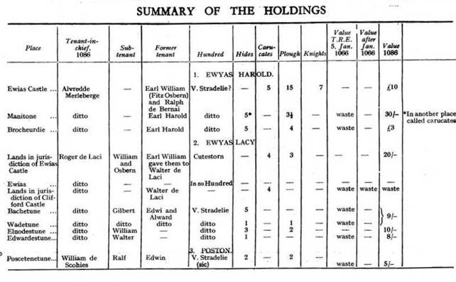
The seven feudal holdings covering the district under review as set out in the Domesday Survey, which was made in 1086, must now be examined, and an attempt made to identify the places mentioned in that document, and the extent of the lands held by each tenant-in-chief.
1. Ewyas Harold.
The Castlery of Ewyas Harold was probably reckoned as in valle Stradelie at the time of the Survey[8] , and was the oldest Norman settlement in the district, the motte and bailey having been constructed about 1046 in the time of Edward the Confessor, as has already been related. Domesday Book tells us that Alured de Merleberge[9] (Marlborough) held of King William the castle and the lands belonging thereto, which Earl William Fitz Osbern had given to the King, and that Earl William had refortified the castle. This refortification would have consisted of re-erecting the palisades, the wooden tower on the motte and other necessary buildings which had been destroyed in 1052. Later these wooden defences were in part replaced by stone.
The land attached to the castle consisted of 5 carucates, probably all lying within the present parish of Ewyas Harold, but part may have been in Dulas, and another 5 carucates (called hides in another entry[10] ) at Monnington in the parish of Vowchurch and probably co-terminus with this parish, except for the lands at Poston and Chanstone. Alured also held in the valley of Stradelie (the Golden Valley) 5 hides at Brocheurdie. The lands at Monnington and Brocheurdie were waste at the Conquest, but at the time of the Survey were worth 30/- and £3 respectively. Brocheurdie must have been the land on the left bank of the Dore in the north part of Abbey Dore parish, including Morehampton and Blackbush. The name would seem to partly survive in the " Black “ = " Du " in place names in the area.
There are no mottes in this castlery except at Ewyas Harold, unless there was one at Monnington, which is improbable. If any knights of the overlord here were subinfeudated during the eleventh or twelfth centuries the district may have been considered sufficiently safe to render any fortification of this sort unnecessary, a moated site such as is to be seen at Monnington being all that was required for reasonable security.
2. Ewyas Lacy.
The lands of Ewyas afterwards known as Ewyas Lacy, lying under the Black Mountains, were given at the Conquest to Walter de Lacy, who died on the 22nd of March, 1085, from a fall from the walls of St. Peter's Church in Hereford, which he was having built. His son Roger de Lacy, one of the most powerful barons at the time, was in possession when the Survey was made. From this we learn that Roger held on the borders of Ewyas, i.e., Ewyas Harold, a territory which belonged to no hundred, and from which he drew 15 sestiers of honey and 15 swine when the men were there, and that he had pleas over them. This land had up to the Conquest been unconquered from the Welsh and included what are now the parishes of Clodock, Longtown, Llanveynoe, Newton, St. Margarets, Michaelchurch Escley and Crasswall, and Walter de Lacy was empowered to occupy and hold what he could. In addition to this land Roger held four carucates in Cutestorn Hundred which were waste when Earl William Fitz Osbern gave them to Walter probably at the same time that he made over Ewyas Harold to the King, for these four carucates were within the jurisdiction of the Castlery of Ewyas Harold. This land would seem to have comprised the parishes of Rowlstone and Llancillo, adjoining Ewyas Harold and bounded by the Monnow on their south sides. It was held under Roger de Lacy by William and Osbern and on the demesne they had two ploughs. The mottes on these two places may have been thrown up by these men, or at any rate by their successors, when the land would have been reclaimed, for at the time of the Survey it was worth 20/-.
Walterston, possibly named after Walter de Lacy, was most likely part of the territory outside the Hundred of Cutestorn, as by its Norman name it was evidently an occupation subsequent to the Conquest unlike the earlier Welsh sites of Clodock and Llanveynoe, where churches were already in existence before 1066. Here Walter constructed a motte to guard the extreme southern limit of his newly acquired property.
Of the smaller tenants-in-chief in Herefordshire, Henry de Ferieres held in Cutestorn Hundred in the jurisdiction of Ewyas Harold Castle three churches and a priest and Roger (no doubt de Lacy) held them of him. Two of these churches must have been Llancillo and Rowlstone, and the third may have been Walterstone, as these three churches were given by the de Lacies, who had probably acquired full possession of them, to Llanthony Abbey, which supports the evidence available for their identification.
At Clodock on the south-west of the Olchon Brook, where the road from the south of the valley crosses it, is a motte called Pont Hendre, an outlier to the chief motte and bailey castle of the Lordship of Ewyas, which is a little farther up the valley at Longtown. This motte may be rather later in date and have superseded the Pont Hendre[11] site, advantage being taken of an already embanked position dominating the junction of two valleys. The motte has been made at the north-west corner of a nearly square embanked enclosure of Roman origin, and an angular bailey constructed in this section of the older earthwork. On this motte towards the end of the 12th century a fine circular keep was built in stone and at the same time, or somewhat later, the curtain wall to the outer enclosure or bailey was made. The earlier earthwork formed a second or outer bailey.
Roger de Lacy also held Bacton, in the valley of Stradel, as 5 hides, and Wadetune as 1 hide. These two manors Gilbert held of Roger. They were waste, but at the time of the Survey were worth 9/-. In the same valley Roger held Elnodestune as 3 hides and William held of him. It was worth 10/-, but the Survey says nothing of its previous value, or whether it was waste. Roger also held here Edwardestune as 1 hide, and Walter of him. This land was worth 8/-, but was formerly waste. It will be noticed that these lands, composed of two 5 hide units, and were so reckoned and not in carucates as was land that was Welsh before the Conquest. Further, all the carucated lands were in the diocese of Llandaff, while those hidated were in the diocese of Hereford.[12]
At Newcourt in Bacton is a small motte and bailey castle, no doubt planted on the land of the 5 hides of Bacton and the 1 hide of Wadetune. This latter place was probably land bounding the southern part of St. Margarets still heavily wooded, and which did not lie within the bounds of the Lordship of Ewyas.[13]
That the two other manors Elnodestune and Edwardestune adjoined Wadetune may be considered certain, for in enumerating a lord's holdings the Survey seems to have taken them in the order of contiguity as nearly as possible. With such a consideration in mind, Elnodestune can be no other than the lands of Chanstone on the west or right bank of the Dore, which river seems to have formed the boundary of Roger de Lacy's holdings in this district, and it may be tentatively suggested that Edwardestune is represented by the parish of Turnastone, where is a motte known as Cothill. This fits in with the identification of the holdings in the Survey that belonged to the Honour of Snodhill. Against it, however, is the fact that Turnastone is found in 1221 in the possession of William de Anesyia (Dansey),[14] and in 1250 his son Richard* held it as of the Honour of Snodhill. A survey of the Manor of Snodhill made in 1824[15] includes within its boundaries Turnastone and a portion of land to the south of it, situated in the parish of Vowchurch, and also the land in Vowchurch on the right bank of the Dore on which Poston Court is situated. In the middle of the 14th century the Danseys held Chanstone and Turnastone as of the barony of Snodhill.
On the settlement of the dispute made circa 1132-1134 between the. Bishops of Llandaff and Hereford, a letter was directed by the Archbishop of Canterbury to Roger de Chandos (Lord of Snodhill), Ralph de Tornai (probably the owner of Turnastone, from which he took, his name or more likely vice versa), Roger de Bachingtona (Bacton) and his men of Possintone (Poston) and the parishioners of Bachington, Peterchurch, and St. Leonard's, saying that in future all the persons above mentioned are to obey the Bishop of Hereford as their bishop[16] . Exactly where Robert de Bachingtona's men at Poston lived is uncertain, but they may have been those at Chanstone in Vowchurch, for this name of the parish does not seem to have been used till a much later date, or on the land of Poston on the right bank of the Dore. St. Leonard's here mentioned is evidently Turnastone, for later references are found of " Turnastone and the chapel of St. Leonards," but in what relation, they stood to one another is uncertain. No old site of a chapel is known and Turnastone is not dedicated to St. Leonard[17] .
If the identification of Edwardstune suggested above is correct it would seem that there must have been a transference at some date between 1132 and 1221 of these lands from the de Lacys to the Chandoses, the holders of the Snodhill Honour. There appears to be only one alternative and that is that Edwardestune was the northern part of St. Margarets. There is an Edward's Place in this parish, but this is probably a modern name. Against this alternative is the fact that the one hide was worth 8/- against 10/- for the three hides at Chanstone; such a valuation renders it most improbable, but as a motte was established at Turnastone and the land brought back into cultivation it might well have been worth 8/- in comparison with Chanstone's 10/-. When the Honour of Snodhill is considered further support will be found for Edwardestune being Turnastone.
There remain two further holdings to be considered at the, northern extremity of the Castlery of Ewyas Lacy, one of four carucates in the jurisdiction of the Castlery of Clifford, which at the time of the Survey Roger de Lacy held, and his father before him. They were and are waste. It would seem probable that the motte at Nant-y-bar was placed on these four carucates, for in a survey of 1667[18] the boundary of the lordship is taken to Mynydd Brith, so leaving Nant-y-bar in Ewyas, but in a later survey in 1701 they both appear to fall outside this boundary, but the survey is difficult to follow. Both are now in the parish of Dorstone, so they may belong to that lordship, but two would hardly have been required in such close proximity, unless Nant-y-bar, a much stronger position, superseded Mynydd Brith.
The other Lacy holding was in Cusop, where Roger held part of Cusop from the King, and the dues from it went to Kingstone. The motte and bailey .known in recent times as Mouse Castle, but formerly as Llwgad or " The Look Out " , commands a full view of the Wye valley and was presumably built by Roger on this part of Cusop
It will be noted that the great baron Roger de Lacy held both the Castleries of Ewyas Harold and Ewyas Lacy, whose custodians no doubt were glad of his support. These lands seem eventually to have been incorporated in the Lordship of Ewyas and were included in the Hundred of Ewyas Lacy when that was formed, but not the Cusop holding.
3. Poston.
This small manor (Poscetenetune)- was held by William de Scohies, and Ralph held of him. There were two hides. It was waste and now worth 5/-.
It was not a caput, or head of a fief. The land lay in what is now the present parish of Vowchurch and must have comprised the land in that parish, excluding Monnington and Chanstone, possibly with the exception of the strip on the right bank of the Wye on which Poston. Court stands which is in the parish, but in the manor of Peterchurch, otherwise the Honour of Snodhill.
There is no evidence of any Norman motte having existed here, but at a later period, perhaps in the thirteenth century, a fortified site was constructed on the right of the roadway leading to Peterchurch; later to be superseded by the present Poston Court on the other side of the river.
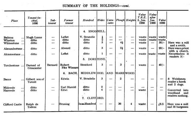
4. The Honour of Snodhill.
Adjoining and north of Poston was the important fief of Hugh L'Asne, known later as the Honour of Snodhill. The name Snodhill does not occur in Domesday Book, but Hugh held in valle Stratelie five estates or manors, namely, Beltrou of half a hide and Wluetone of two hides, these two estates (terrae) were and are waste; Wilmestune where there were five hides and a mill worth 3/-, it was waste now worth 30/- ; Almundestune of three hides with two Frenchmen with two ploughs, and a priest with a church having half a plough, it was waste now worth 20/- ; Alcamestune of one hide, it was and is waste, but nevertheless renders 3/-. All these places had been held by Leflet except Almunstune which Alward held.
The exact boundaries of these holdings cannot now be defined, but Wilmestune is evidently the present Wilmastone, on which land was built Snodhill Castle, a large motte and bailey later to be strengthened with stone walls. Beltrou would seem to be the land at the Godway on the ridge above Wilmastone, where is now a wood known by that name[19] . Wluetone no doubt adjoining Beltrou, may be located as Lyonshall, which manor was held with Turnastone in 1221[20] by William Gansey and remained in this family for many generations. Almundestune with its priest and church is undoubtedly the present village of Peterchurch with the manor of Hinton adjoining. Alcamestune was probably Urishay, where there may have been later a motte and bailey, but as it was waste none would have been erected at the time of the Survey and the explanation of its paying 3/- may be that though waste there was a hay there for ensnaring game and it was worth that amount. It has been suggested that this manor was Chanstone, but this seems impossible, and the possibility of its covering Turnastone has been dealt with under the Ewyas Lacy Honour.
5. Dorstone.
Adjoining and north of Snodhill was another tenant-in-chief holding lands at Dorstone (Torchestone), namely Durand of Gloucester. Bernard held of him and there were three hides geldable. Before Robert Fitz Wimarc held it. It was waste now worth 40/-. Bernard who held it was probably Bernard de Newmarch, who later was to distinguish himself as the conqueror of Brecknock. When he established himself there he gave the manor of Tredustan in Breconshire to Sir Humphry Solers and the family of Solers also held Dorstone in Herefordshire, no doubt under Bernard. Jones in his History of Brecknockshire thinks that Sir Humphry Solers had an elder brother Thurstan, standard bearer to William the Conqueror and that it was from him that Dorstone and Tredustan got their names. The " Tre" in the latter indicates that the " dustan" is derived from a personal name. The " T" in the Domesday spelling, and a deed with spelling " Dorstonstone" dated 1303, supports this derivation, the name being " Thurstanston" , the last syllable being dropped out later. It certainly does not seem unlikely that a Thurstan, from whom they derived their name, may have held both places before the Survey, though the Domesday Book tells us that the former holder of Dorstone was Robert Fitz Wimarc. The two estates were certainly held by the same families for a number of generations[21] .
At Dorstone is a fine motte and bailey, which at a later period has been fortified in stone.
At the extreme western end of the parish are the mottes at Mynydd Brith and Nant-y-bar, which have received consideration when reviewing the Ewyas Lacy lands.
6. Bach, Middlewood, and Harewood.
These lands in valle Stradelie lie on the northern boundary of Dorstone, but mostly in the parish of Clifford. They were held by Gilbert the son of Turold, apparently no connection of Gilbert the sheriff found at Clifford.
At Bach (Beece) were three hides, Edwin held it. There are 8 Welshmen with 2 ploughs, and they render 1 hawk and 2 dogs.
At Middlewood (Midewde) were 2 hides. Earl Harold held it. Nothing is said as to its being waste or returning any rent.
At Harewood (Harewde), now represented by Hardwick, where there is still a wood bearing the name, were four hides. Edwi held it. This land has all been reclaimed into woodland. It was waste and renders nothing.
Between Middlewood and Bach is the motte and bailey castle of Newton, no doubt erected on Gilbert's holding on a nameless site as the name implies. The angular lay-out of the bailey points to a late date for its foundation, and there are indications of the bailey having been defended by stone walls.
7. Clifford.
The Castelry of Clifford was a most important stronghold and one of the first sites to be fortified when the Normans descended on this border immediately after the Conquest. The Survey tells us that Ralph de Todeni held the castle of Clifford, William the Earl[22] (FItz Osbern, Earl of Hereford) made it on waste land which was held by Bruning, in the time of King Edward. It is of the usual motte and bailey type, the motte being formed like that at Ewyas Harold by severing a jutting tongue of high land overlooking the river from the main body by a deep cutting. It was at least partly fortified in stone in the latter part of the 12th century, as in recent excavations made by the late Dr Oscar Trumper the foundations of a small rectangular keep were uncovered in the centre of the mound.
The Survey further says that the castle was part of the kingdom of England, was not subject to any Hundred[23] , or to customary dues. Gilbert the sheriff held it at farm with the borough and one plough, and for the whole rendered 60/-. There was land for three ploughs, but there was only one. Four knights held various ploughs, Roger had land for four, Gilbert for twelve, Drew for five, and Herbert for two. These knights also had on the demesne nine ploughs, and the men had three, with a mill, etc., the whole was worth £8 5s. 0d.
Of these knights, Roger was Roger de Lacy (whose four carucates of land have been dealt with under Ewyas Lacy, Drew or Drogo was Drew Fitz Pontz, a Herefordshire tenant-in-chief and founder of the house of Clifford, Gilbert was the sheriff who had the castle to farm, and Herbert was probably the same man who held land under Ralph de Todeni in Worcestershire.
There is one other motte and bailey, namely, Castleton, near the bank and lower down the river Wye in the Clifford castlery. It is not mentioned as a manor in the Survey, so probably it is of later construction. It is a fine specimen with several baileys and was evidently a strong and important post guarding a ford across the river as did Clifford. It may have been founded on the twelve plough lands held by Gilbert the sheriff.
8. Cusop.
The Survey tells us that in the time of King Edward a part of the land of Cheweshope (Cusop) belonged to Kingstone (in Herefordshire), and that Roger de Laci holds it of the King. It has been dealt with under Ewyas Lacy.
-------------
Such then was the condition of this border country in 1086. At the time of the Conquest the western part, comprising the Lordship of Ewyas Lacy under the Black Mountains, was still independent of Saxons or Normans and in no Hundred, and the lands belonging to Ewyas Harold are not assigned to any Hundred, while those of Dorstone are said to be in the Hundred of Stratford. All the other lands in the area under consideration, except part of Clifford, which was in no Hundred, and Cusop, were in the valley of Stradel. The land in this valley was not reckoned as a Hundred and so presumably had no Hundred Court at which the dues were paid. Probably these were collected individually by the Sheriff or paid directly to him at the Shiremoot. From this it may be inferred that the Saxon occupation of the; district took place after the Hundreds were formed. ,
There-is a special entry in the Survey which says, In valle Stradlie are 56 hides which 112 ploughs could plough and they pay geld. This note must have been made to show that the properties were taxable, though not responsible to any Hundred Court. It is difficult to reconcile these 56 hides with those recorded as being in the valley of Stradel. There are only 42½ hides (or carucates) definitely stated to be in valle Stradelie, to which presumably the 5 carucates of Ewyas Harold Castle may be added, making 47½ in all.
An entry under the lands belonging to the Canons of Hereford tells us that in Stradel Hundred they have 1 hide worth 5/- in More, and the same Canons have 4 hides worth 15/-, and Bishop Walter had 1 hide of Welsh land laid waste T.R:E.[24] and that there were 2 ploughs on the demesne and the men had 6 ploughs. It was worth 40/-. Of this land the greater part is within the King's enclosure
The Victoria County History identifies More as " Moore near Hereford " , whatever that place may be, and an anonymous writer[25] as Canon Moor. The latter identification cannot well be possible as most of the land lay in the King's Forest, and Canon Moor is on the other side of the river. The land may have been in what was later Alansmore, when the enclosure would be the King's Forest of Hay, or perhaps what is more probable the land was on the borders of Kingstone, lying in the Grey Valley, where the placename " Moor" is found, when the King's enclosure would be the Forest of Treville, which extended in places to the banks of the Dore. Unluckily it has not been possible to support either of these possible identifications by later evidence, but the land being in Stradel Hundred supports the latter suggestion. This is the only mention of a Hundred of that name, and the situation of the lands may have been so designated because the land was not actually in the Golden Valley[26] . If so the dues were most likely paid in the same manner as those of the lands in valle Stradelie and not actually through a Hundred Court.
If these 6 hides are counted as in the valley it brings the number to 53½
There are 3 hides in Dorstone which lie definitely in the valley but are distinctly stated to be in Stratford Hundred, so would not have been included in the 56 hides. The problem then remains unsolved and possibly unsolvable. It may be some land by a clerical error has been omitted when the Domesday Book was drawn up in a condensed form from the original Survey returns, which included details not found in the final summary.
The state of the land in the district at the end of the 11th century may be gathered from the Survey. At the time of the Conquest nearly all the manors are stated to have been " waste" , and of the remainder no description is given, so it may be considered that these were also " waste" . In 1086, the date of the Survey, six of the manors were still waste out of the fifteen actually specified as in this condition in 1066. This discloses the terrible plight to which the district had been reduced by the depredations of the Welsh in 1052, and of Prince Gruffyd in 1055 and the subsequent unrest on this border.
A reflection on what occurred when land in these early times was what was termed " waste" , will bring home the pitiable condition of the inhabitants who survived a raid of hostile warriors. The wealth of the people lay in their stock of food for man and beast -corn, straw, and hay - their small flocks and herds and what was most important the oxen and ploughs for cultivating the land. The small household goods might be hidden, but the other possessions were not so easily secreted. When fire had done its worst with houses, fodder and grain, and the oxen and other live-stock were driven away, sorry indeed must have been the plight of the surviving inhabitants, left as they were with practically nothing and no available means wherewith to replace the ox team and the plough. What little seed corn they could collect must have been cultivated by hand until the few surviving beasts had brought forth their increase, a matter of many years, as a perusal of Domesday Book will prove.
The above summary and the imperfect deductions on the Domesday holdings between the Golden Valley and the Black Mountains may help to place in their true perspective the origin and period of construction of the numerous small and large " tumps" that dot this countryside. There are earlier and later earthworks, and even natural knolls confused with the Norman motte and bailey castles, but these latter have such distinctive features that they are easily recognisable after a little observation.
Much more light can still be thrown on the history of these parts by a careful study of Feudal Aids and Donums, the Pipe Rolls, The Book of Fees, Inquisitions Post Mortem, the study of parish place-names, etc., and thus working backwards from the known to the unknown anyone who would apply himself to this task would be amply rewarded.
An analysis of the Herefordshire Domesday Survey is also badly needed, for in it is buried much historic and economic information which does not appear on the surface.
[1] Liber Landavensis, ed. by Rev. W. J. Rees, 1840, p. 442.
[2] Probably the Yellow Pestilence
[3] Liber Landavensis, p. 374.
[4] Liber Landavensis. p. 376.
[5] Ibid, p. 583.
[6] WoolhopeClub Transactions. A Chartulary of Hereford Cathedral, p. 274
[7] It may have been at this time that the castle of Hereford was first built.
[8] Dr. Round in The Victoria County History, p. 266, states that the castellany of Ewyas (Harold) was in the Hundred of Cutestorn, but the Survey nowhere makes this statement. Under the holdings of Roger de Laci there is mention of 4 carucates in that Hundred in the jurisdiction of the castellany. Though not definitely stated it may be inferred that it was in voile Stradelie because Monnington, which in a later entry is stated to be in the valley, is grouped with Ewyas Harold
[9] He was nephew of Osbern Pentecost, who built the castle in 1046
[10] Both entries are on p. 186 in the Survey
[11] The name Hendre confirms this being equivalent to " the old house”
[12] Llandaff claimed the latter, but in 1132 Bacton, Turnastone and Peterchurch were confirmed to Hereford. 'Woolhope Transactions, 1917, p. 274, ex a Lost Chartulary of Hereford Cathedral.
[13] Cf. Perambulations of the boundaries of Lordship of Ewyas in 1667 and 1701. Duncumb's History of Herefordshire, vol. II, pp. 271-273.
[14] Inq. Post Mortem
[15] In the Hereford Public Library
[16] See " A Lost Chartulary of Hereford Cathedral," Woolhope Transactions. 1917, p. 274.
[17] Post 1938 note - Click here for later details of St Leonard’s Chapel
[18] Duncumb's History of Herefordshire, 1812, vol. ii, p. 272
[19] I am indebted to Mr. R. S. Gavin Robinson for this information
[20] Inq. Post Mortem
[21] See Jones' History of Brecknockshire, 1898 edition, pp. 47, 352
[22] It was forfeited in 1078 by Earl William's son who succeeded his father in 1070, on account of his rebellion.
[23] At time of the readjustment of the Hundreds, it was included in the new Hundred of Huntingdon, in which it still is.
[24] Post 1938 note –T.R.E Is a common Domesday abbreviation, - tempora regis Eduardis In the time of King Edward the Confessor; by implication, when all in the realm was legally correct and ownership would have been rightfully secured.
[25] Ancient and Modern Names of Places in the Domesday Survey of Herefordshire. Hereford. 8vo. n.d
[26] Post 1938 note- ‘More’ has since been identified as being Whitehouse in Vowchurch’
|
|
|
|
Observations:
Reproduced from the Transactions of the Woolhope Naturalists’ Field Club with the permission of the Central Committee
Ref: gc_gdv_3001