
Held at: | Private collection |
Reference: | RS |
Source: | Original document |
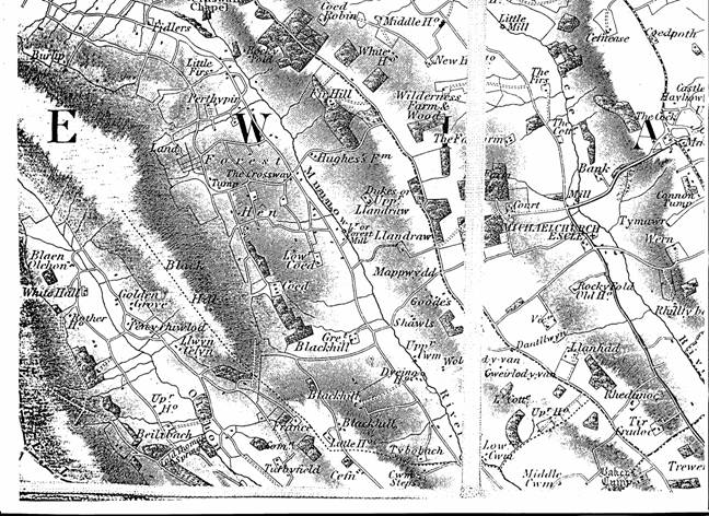
Title: | Map of Michaelchurch, Crasswall and Urishay area (part 2) |
Place name: | Ewyas Lacy |
Date: | c.1835 |
Description:
Bryant’s Map shows the principal dwellings and place names in the Escley and Monnow valley area in the early 19th century.
Observations:
| Places shown: | Baker’s Tump | Bank (farm) | Beilibach | Black Hill | Blackhill |
| Blaen Olchon | Burlip | Cannon Tump | Castle Hayhow | Cefn | Cefnease |
| Coed | Coed Robin | Coedpoth | Cold Thomas Spring | Court (Michaelchurch) | Cwm Steps |
| Dantlbryn | Dukes (Upper Llandraw) | Dyeing House | Escle (Escley) | Farm Wood | Fidlers |
| Fir Hill | Forest Mill | France | Golden Grove | Goode’s | Great Blackhill |
| Gweirlod-y-van | Hen | Hughes’s Farm | Little Cottage | Little Firs | Little House |
| Little Mill | Llandraw | Llanhad | Llwyn Celyn | Lower Coed | Lower Cwm |
| Mappwydd | Michaelchurch Escle | Middle Cwm | Middle House | Mill (Michaelchurch) | Munnow (Monnow) |
| New House | Olchon (Brook) | Pen-y-rhiwlod | Perthypin | Rhedunoc | Rhillty |
| Rocky Fold | Rocky Fold Old House | Rother House | Shawls | The Cock | The Cottage |
| The Crossway | The Farm | The Firs | Ti Cradoc | Trewern | Turbyfield |
| Tybobach | Tymawr | Upper Cwm | Upper House | Upper House | Vicarage |
| Wern | White Hall | White House | Wilderness Farm | Wilderness Wood | Wold-y-van |
Ref: rs_ewy_0019