
Held at: | Internet |
Reference: | http://archaeologydataservice.ac.uk/archives/view/phillips_2005/ |
Source: | Internet – Archaeology Data Services [University of York] |
Title: | Earthwork Castles of Gwent and Ergyng AD 1050-1250: Mynydd Brith |
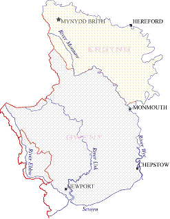
Place name: | Cusop |
Date: | 1050 - 1250 |
Description:
This summary concerning Mynydd Brith is an extract from a Doctoral thesis by Dr N Phillips, University of Sheffield (2005), entitled ‘Earthwork Castles of Gwent and Ergyng, AD 1050-1250’. This thesis is concerned with the earthwork and timber castles built in the southern March of Wales, addresses the presence of the castles and discusses their roles as weapons of conquest and structures of administrative control.
MYNYDD-BRÎTH Grid: SO 27997 41463
Location:
The site is reached by travelling east from Hay on Wye along the B4348. After passing through Cusop a small road to the left is sign-posted Dorstone. This road leads up to the top of the hill and as it starts to drop down into the valley a sharp right turn leads back up to the site of Mynydd-brîth.
Description:
The motte at Mynydd-brîth is situated on the northern slope of the pass through the hills between Hay on Wye and Dorstone. The site stands on high ground above a stream that eventually runs past the site at Dorstone. The site is in very close proximity to another motte called Nant-y-bar (see below). The earthwork today consists of a conical motte sat on the edge of a steep valley side, in a field next to a house, with a road limiting the extent to the north-east and steep stream banks to the north, west and south. The motte itself has almost a complete circle of low masonry wall around the rim, (see below). To the east of the motte is a slight rise which forms a crescentic bank, interpreted as a possible horn-work; unusually, on the uphill side. The photograph shows the north-west side of the motte, which is on the right, and the valley on the left (Vol. 2. plate 180). A very faint ditch is just about visible in front of the motte and the foreground of the photograph is part of the horn-work. The aerial photograph, (Vol. 2. plate 181) shows the motte in the centre, with a horn-work below and to the right.
The whole area appears to be located on extensive earthworks that probably have some association with the medieval site. The earthworks may extend to the farm on the other side of the road, (top left), where to the right of the farm buildings can be seen ridge and furrow plough marks, a rectilinear feature and some curvilinear ditches. These features were noted during survey work carried out in 1994 for English Heritage, (see below).
The 1908 map shows the layout (Vol. 2. figure 88). There are traces of a rampart and ditch to the south east, as shown on the second photograph (Vol. 2. plate 182). Unfortunately the site has been much altered by the road and the modern buildings so these features may not be original. They were, however, recorded on the later 1931 plan (Vol. 2. figure 89).
Topographic survey: (Survey 35)
The motte at Mynydd-brîth occupies the edge of a steep ridge above a stream and in so doing makes good use of natural defence to enhance its security. The site exhibits a motte with a maximum height of 5.27m at a gradient of 81.18% and a top surface area of 213.658m². The top surface rim has five sections of low masonry wall, linear in shape and all well cemented. Whether the masonry is original is not known but, if it is, then the motte had an angular shell-keep.
Only two small sections of ditch are visible and it is not possible to tell their original extent. The one to the east of the motte has a maximum depth of only 0.33m and the one to the south reaches a depth of 1.36, for a very short distance. Evidence for a bailey at the site is minimal, restricted to a few surface anomalies to the west of the motte.
Documentary evidence
Primary reference:
Evidence for the castle does not exist but the name ‘Mynydd-brîth’ is recorded in Db.H as being held by Drogo son of Poyntz (Thorn and Thorn 1983. 186 c, d).
Modern reference: HWCM1241
Marshall suggested that Mynydd-brîth was earlier than Nant-y-Bar because of its weaker position. He further suggested that Mynydd-brîth may have been held by Roger de Lacy but his assumption was based on lordship boundaries for 1667 and 1701 (Marshall 1938. 150). The site was surveyed. In 1994 The Archaeology Service, Hereford and Worcester County Council carried out a survey of the site for English heritage (Jackson 1994.). The purpose of the survey was to produce a conservation and protection plan for the site. During the process Mr Stirling-Brown helped the department by clarifying his past operations at the site. In the report much comparison was made between the plan drawn by R.S. Kay in 1952 and the survey produced for the report (Vol. 2. figures 90 and 91). The conclusions noted that the site had suffered ‘tidying’ and ‘renovation’ work as well as unauthorised excavation. It noted that walls were exposed where walls had not been visible before and that the motte was somewhat lower now than when Kay recorded it (Jackson 1994.).
Unfortunately Mr Stirling-Brown’s efforts to ‘tidy’ and ‘renovate’ the site has led to doubt about its original form. The third photograph shows a very substantial masonry wall across the south-east edge of the motte (Vol. 2. plate 183). A doorway appears to be set, at the bottom of the photograph. The last photograph shows the east end of the motte top complete with a low rectangular building base (Vol. 2. plate 184). As was mentioned above, the date of the masonry may date from medieval times or the 20th century. There is no way of knowing for certain but it certainly wasn’t as prominent in 1908, 1931 or 1952.
Additional references:
VCH 1908. 236.
RCHME 1931. 57.
King 1983. 205.
Interpretation: Motte and possible bailey (Early)
The remains of the motte are a little problematic as it is known that the site has been tampered with by a former owner, who has more than a passing interest in earthwork castles. The motte has a variety of masonry foundations most of which were possibly modified fairly recently. The former owner, Mr Stirling–Brown, is a well known castle researcher in the area and apparently worked within the control of English Heritage (pers comm.).
It is difficult to be certain what remains are original, the result of repair, or the result of well-intentioned reconstruction.
The interpretation of the site, based on actual remains, survey and location is that the site probably functioned as a frontier outpost and is therefore early. The small nature of the site would have restricted its use to a small garrison and there is evidence of private internal fortification for the motte. The masonry structure on top is not convincing and is best disregarded but in its excavation or construction an unknown amount of earth from the top of the motte would have been moved. It is therefore possible that the motte may have been higher.
Observations:
The material is copyright by the author, and is reproduced here from the Archaeology Data Service website of the University of York for research purposes under their terms of use
Ref: rs_cus_0058