| INTRODUCTION | 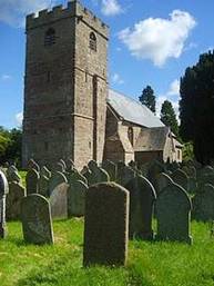
| | Clodock Church (existing building from late 12th century) | A church at Clodock, dedicated to the Welsh saint, St Clydawg, was the focal point of an ‘estate’ of surrounding lands which some three centuries before the Norman Conquest appears to have been the heartland of a later evolving parish. ‘Estate’ is a term of convenience adopted to refer to land associated with a church or monastery in the Early Medieval period (or ‘Dark Ages’); the term does not imply any specific land use but rather conveys, in a very general way, entitlement to an area of land. A mid-8th century record shows that the boundary of lands belonging to Clodock church was well defined at that time, even though the names of many landmarks have been lost. This paper attempts to identify landmarks, retrace the route on the ground and map the estate, as far as possible, to give an idea of Clodock as it was in the earliest written record of the church and its surroundings. The boundary came to be recorded when the Clodock estate was subject to rival claims of ownership by the Dioceses of Llandaff and St Davids in the 12th century, along with other disputed churches and their lands elsewhere in southeast Wales (including then part of Herefordshire)[1]. The Diocese of Llandaff set out to validate its territorial claims from 158 charters of initial land grants, compiled in a document known as the Book of Llandaff ’ (or Liber Llandavensis ), completed c1130. The charters themselves were copied from earlier, though undated, sources which however can be dated from stylistic features and circumstantial evidence, including persons named as donors or witnesses of the land grant. The Clodock charter, as summarised by Wendy Davies, records that ‘King Ithel gave territorium Merthirclitauc to the martyr Clydog and to bishop Berthwyn with the guarantee of his sons Ffernfael and Meurig and consent of the heretiarii Ithel and Ffreuddwr’[2] . These names, known from other contexts, place the date as c740[3] .
The land grant forms only part of the Clodock charter material. Although it is the only datable part, there are also four legendary stories or ‘narrations’ associated with the church and its land[4] . These narrations tell of the martyrdom of St Clydawg near the river Monnow where the church was founded; of a quarrel between two men who visited the sepulchre to make peace, which proved to be unsuccessful; of three hermits who were the first inhabitants and cultivators after the martyrdom of Clydawg, and the subsequent division of the land into five parts; of the sin of a rich man, Ithel, who took a meadow by force and in repentance ‘placed it on the holy altar of Clydawg’. The narrations provide a wealth of interest for local historians, but are outside the scope of the present study: a transcription and comment can be found elsewhere on this website [click here] .
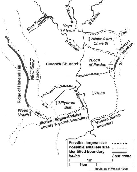
Clodock’s boundary is described as a ‘perambulation’ tracing a route around the estate which clearly reflects an intimate knowledge of the local area in terms of topography and place names. From the amount of detail given, and despite many lost place names, its route can be partially reconstructed as discussed here and illustrated on the attached sketch map. Previous reconstructions by Bruce Coplestone-Crow and by Lynda Rollason (whose study included fieldwork) have been an invaluable resource.
|
|
TEXT OF THE CHARTER
A translation of the Clodock charter from medieval Welsh was published in 1893 by JG Evans[5] and reads:
| ‘MERTHIR CLITAUC = CLODOCK, Her. Its boundary is: The stone in the Weun Vraith on the Cecin, N. end of Hatteral Hill [sic[6] ] along it to the Rhiw Gwrw, to the stone on the Cecin of the Allt, along the Cecin, the ridge of the Brec. Black Mountain , upwards as far as the stones opposite to Nant Trineint, the Turnant , along it downwards as far as into the Olchon, along it, the Olchon , downwards as far as Ynys Alarun at its top end, to the Maen Tyllog to the Crug, to the other Crug, to the Monnow, across the Monnow to Aber Nant Cwm Cinreith, the Nant throughout its length as far as Mynyd Ferdun above the Allt, along Mynyd Ferdun, to the Loch of Ferdun, along the mountain to the source of the Hilin as far as the Monnow. Along the Monnow downwards as far as Aber Ffynnon Bist , along the Ffynnon Bist as far as its source. From its source to the Cecin straight upwards making for the Weun Vraith on the Cecin of the mountain, as far as the stone, where the boundary began[7] .’ [Italics in the text are as used by Evans for editorial comment.] | This translation forms the basis for numbered sections of the route in the reconstruction below. |
|
RETRACING THE ROUTE
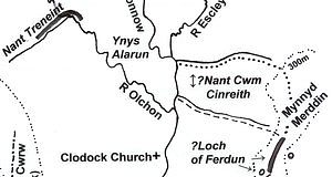
[Click here to see the full map]
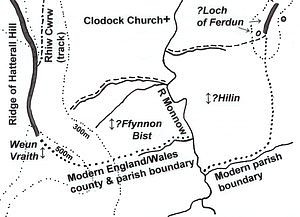
1. The stone in the Weun Vraith on the Cecin
The boundary description begins on the Cecin , which Evans interprets as ‘ridge’ (ie the ridge of Hatterall Hill[8] ), which in the vicinity of Clodock is at about 500m OD, rising to 530m further south. Keith Ray notes that weun presumably stands for ‘gwaun’, plural ‘gwenydd’ meaning ‘moors, meadows’, and this would suggest a stone standing in the broadest part of the Hatterall Ridge[9] . Frank Olding has identified a series of prehistoric earthworks along the ridge of Hatterall Hill, including a cluster at or near the highest point[10] . The name Vraith , possibly derived from ‘braich’ meaning ‘promontory’ also supports a location here. Lynda Rollason begins her field investigation in this area (at SO 308259), where there is evidence of extensive quarrying, and continues northwards as indicated by the next instruction.
2. along it [the Cecin] to the Rhiw Gwrw
An existing track known at the present time as Rhiw Cwrw[11] crosses the ridge at SO 308270. It is a well defined right of way leading diagonally along the eastern slope of Hatterall Hill. 3. to the stone on the Cecin of the Allt
Evans interprets ‘allt’ as ‘hillside’. Though no distinctive stone exists, Olding’s evidence of prehistoric earthworks suggests the likelihood of a former standing stone[12] . 4. along the Cecin upwards as far as the stones opposite Nant Trineint
Rollason suggests that the ‘stones’ may be a rocky outcrop on Hatterall ridge. Another possibility is a former cairn or barrow, as noted above.
Trineint has devolved to the existing area name Turnant, which includes several farms - Upper Turnant, Great Turnant, Lower Turnant, Rhula Turnant - and the road, Turnant mountain road. The particular ‘nant’, meaning ‘stream’, could be any of a number of streams rising in the Turnant area; none is now called the Turnant.
|
| 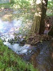
| | The proposed Trineint entering the Olchon | 5. along it [the Trineint] downwards as far as into the Olchon
Within the local catchment area, however, a principal stream forms to provide an identifiable location of the Trineint , shown in this photograph entering the river Olchon at SO 315293,
6. along it [the Olchon] downwards as far as Ynys Alarun, at its top end
‘Ynys’ may refer to an island, a river meadow or a wedge of land between converging rivers. In this context it is likely to refer to land between the Olchon and Monnow rivers (see instruction 9), which would have been downstream from the confluence of the Trinein t; no specific location is identifiable, though the general vicinity is in Longtown. Ynys Alarun appears to have been a sufficiently distinctive place to have a name.
|
|
7. to the Maen Tyllog
The ‘maen’ (meaning ‘stone’) called ‘Tyllog’ (meaning ‘full of holes’) appears to be a local landmark, no longer identifiable.
8. to the Crug, to the other Crug
Evans interprets ‘crug’ as ‘tumulus’. The only visible ancient earthworks are Norman structures, a motte and bailey castle and associated earthworks in Longtown, and a motte at Pont Hendre in Clodock. The possibility of Longtown castle having been established on the site of a Roman camp has long been debated, mainly on the basis of rectangular shaped ramparts. The existence of such remains in the mid eighth century is speculative in the present state of knowledge, and in the absence of conclusive evidence of any earthworks in the Early Medieval period, the two ‘crugs’ remain unidentifiable.
9. to the Monnow
As the boundary crosses from the Olchon to the Monnow, it must have been north of the confluence of the two rivers (at SO 328281) since there is no instruction to recross the Olchon. It must also have been south of the confluence of the Monnow and Escley (at SO 327287), since there is no instruction to cross the Escley. The point at which the Monnow was reached would therefore be within a stretch of about ¼ mile (0.4km). A linear bank crossing between the Olchon and Monnow, reported in an archaeological evaluation, is within in this distance; about 0.5m high and, running in a straight line from the Olchon (at SO 3242 2842) for 200 m, the same line continues along a hedge boundary for 450m towards the Monnow[13] .
|
| | | |
| 
| | Holloway track adjacent to candidate for the stream Nant Cwm Cinreith |
10. across the Monnow to Aber Nant Cwm Cinreith
The stream name here refers to ‘aber’ meaning ‘confluence’,‘cwm’ meaning ‘valley’, and ‘Cinreith’ the name of the valley. The Monnow must be crossed to reach the stream, evidently flowing into the Monnow from the east. Of two existing streams entering the Monnow at SO 328288 and SO 328284, the more southerly may be the more plausible candidate, where a ford leads into a holloway which continues uphill through a wooded valley, or dingle. The holloway is a well defined track (and an existing right of way).
11. the Nant throughout its length as far as Mynyd Ferdun above the Allt
Mynnyd Merddin is the existing name of the hill in this vicinity. ‘Allt’ is here interpreted as ‘steep place’ or ‘wood’; the instruction is to continue up from there to the top of the hill.
|
|
12. along Mynyd Ferdun to the Loch of Ferdun
The boundary ran along the ridge of the hill. Rollason cites early OS maps which show two pools[14] , at SO 342275/6 and SO 338273, either of which could reasonably be the loch described. Ray suggests an alternative interpretation, that the Loch is more likely to be a local rendering of ‘llech’ (meaning ‘stone’, often used to refer to a chamber) than ‘loch’ as meaning ‘lake’, when the usual Welsh term would be ‘llyn’[15] .
| 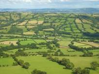
| | Mynnyd Merddin viewed from Hatterall Hill. Clodock Church is in the centre | After passing the Loch of Ferdun , the remainder of the route becomes more speculative, as noted in instructions 13 to 15 below. In broad outline, the boundary follows two streams with lost names; the Hilin flowing from Mynnyd Merddin into the Monnow from the east, and further downstream the Bist flowing from Hatterall Hill into the Monnow from the west. As there are a number of streams to choose from on both sides of the Monnow, these particular streams cannot be identified. A further complication is that the lower reaches of existing streams have usually been diverted into ditches or other drainage measures, so that the natural course is no longer followed. With these provisos, account should be taken of two major constraints on the location of the Hilin and the Bist.
|
| · Effectively the two streams form a zig-zag or ‘dog’s leg’ with a section of the Monnow between them, whereby the Hilin is north of the Bist. · From the source of the Bist, the perambulation leads ‘straight upwards’ to the starting point of the perambulation on the ridge of Hatterall Hill. |
| 13. along the mountain to the source of the Hilin as far as the Monnow
It can reasonably be expected that the Hilin would be south of Clodock church, to allow for the church to lie within its own lands, and for much the same reason a stream entering the Monnow in the immediate vicinity of the church may arguably be discounted.
Observing the instructions in 14 and 15 below would narrow the choices for the Hilin which is likely to have been one of several streams rising on Mynnyd Merddin and entering the Monnow in SO 3227 and 3226 within a distance of about a mile (1.6km) south of Clodock church. For the ‘possible smallest size’, a stream shown on the sketch map closer to the church on the southeast (entering the Monnow at 325271) is a suggested candidate, though there are several others further south.
For the ‘possible largest size’, the stream at the existing parish boundary east of the Monnow (entering the Monnow at 330253) can justifiably be considered since it is an identifiable ancient boundary likely to be many centuries old, and Coplestone Crow’s reconstruction takes this route[16] . However, to meet the constraint of continuing downstream along the Monnow, this choice for the Hilin would place the Bist in a watershed further south on the slope of Hatterall Hill reaching about 460 metres, not as required by the other constraint of leading ‘straight up’ to the ridge. An issue here is whether the Llandaff instruction to proceed downstream should be scrupulously observed: if so, the Hilin is unlikely have been the stream marking the existing parish boundary on the east side of the Monnow. However, if the Llandaff instruction is set aside in favour of an ancient boundary (though of unknown date), this stream could be chosen to mark the Early Medieval boundary continuing upstream on the Monnow to meet the Bist . On balance, a cautious interpretation meeting both of the constraints noted would place the Hilin further north.
14. along the Monnow downwards as far as Aber Fynnon Bist
‘Fynnon’ means a ‘spring’ or ‘well’, which was named ‘Bist’. Instruction 15 below indicates that the Bist would have risen on the flank of Hatterall Hill: a number of streams meet this condition in SO 3226 and 3225.
For the ‘possible smallest size’, a watershed with two main streams formerly entering the Monnow in the vicinity of 325267 would lead up to Hatterall ridge at the level of 500-530m.
For the ‘possible largest size’, a stream entering the Monnow at SO 329258 marks a triple boundary; between England and Wales, the counties of Herefordshire and Monmouthshire, and the parishes of Clodock and Cwmyoy. The first two designations are relatively recent, dating from the 1536 Act of Union. The parish boundary is possibly of Norman date, separating Clodock from Oldcastle where a former medieval church was served by monks from Llanthony Priory.[17] In the light of instruction 15, this stream is the most southerly candidate for the Bist , as its source would lead straight upwards to 530m on Hatterall ridge.
|
| | 
| | Ridge of Hatterall Hill showing the high point of 500-530m OD, the presumed Weun Vraith. On the left/centre, a diagonal line of trees marks the three-fold boundary stream; on the right/centre is another watershed with two candidate streams aligned towards the high point of the ridge | 15. along it [the Bist ] as far as its source. From its source to the Cecin straight upwards making for the Weun Vraith on the Cecin of the mountain, as far as the stone where the boundary began
The boundary continues uphill along the Bist , and from its source to the starting point of the description on Hatterall Hill above the source of this stream, at Weun Vraith on the ridge.
***************************
Given the range of uncertainties, estimates of the area covered in the Clodock estate are conjectural. Identifiable sections of the boundary along the ridges of Hatterall Hill and Mynnyd Merddin provide a west/east axis of some 2 miles (3.2km). The north/south axis cannot be estimated with the same assurance. At the ‘possible smallest size’ this axis (allowing for an irregular shape) would notionally be in the order of 1.25 miles (2km), giving a total area of 2.5 square miles (6.5 sq km), or 1600 acres. At the ‘possible largest size’ the north/south axis would be around 2 miles (3.2km), giving a total area of 4 square miles (10.4 sq km), or 2,560 acres.
To put this area in the context of 158 land grants recorded in the Book of Llandaff, of those where measurements are given[18] most land grants were in the order of 125 acres (Davies reports 44% of those grants citing the area) although ten ranged between 1,500-2000 acres. In a few instances where the measurements are not given, Davies estimates that the four largest ranged from 6,000 to 2,100 acres. For the Clodock estate, Davies gives an estimate of 1,100 acres, and Rollason of 2,500-3,000 acres[19] ; either of these figures or the estimates given in this study would indicate a large estate compared with most others in the Book of Llandaff .
|
|
References
Coplestone-Crow, Bruce (1989) Herefordshire Place Names . British Archaeological Report 214, Oxford
Davies, Wendy (1978) An Early Welsh Microcosm , Aberystwyth
Davies, Wendy (1979) The Llandaff Charters , Aberystwyth
Evans, JG and Rhys, J (1893) The Text of the Book of Llan Dav: reproduced from the Gwynsanene Manuscript , Oxford.
Olding, Frank (2000) The Prehistoric Landscapes of the Eastern Black Mountains , British Archaeological Report, British Series 297, Oxford
Rees, William (1840) The Liber Llandavensis , The Welsh MSS Society, Llandovery
Rollason, Lynda (1975) The Boundaries of the Herefordshire Charters in the Book of Llandaff . Unpublished BA dissertation, University of Birmingham (copy in Hereford Library)
Wedell, Nina (1998) Ewyas Lacy and the Origin of Longtown . Privately published booklet, Longtown |