
Title: | Postglacial Landscape of SW Herefordshire |
Date: | to 10,000 BC |
South West Herefordshire
Post Ice Age Landscape and Settlement Features
A talk given to the Woolhope Club by George Charnock
We are very fortunate to live in a very attractive part of the country, Herefordshire being one of the few parts of England that is still relatively unspoilt. Some of us live here by accident or the fortunes of birth, others come by deliberate choice. All are equally fortunate.
|
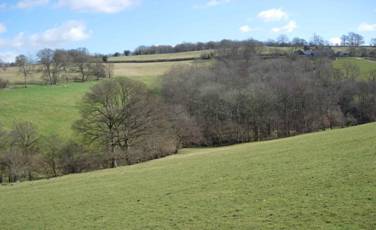
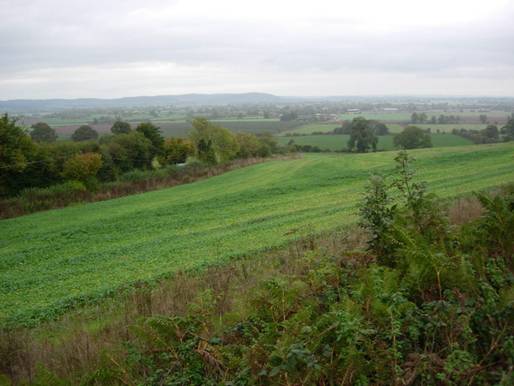
Flat Land at Abbey Dore |

As we travel around the county and perhaps have occasional time to ‘Stand and Stare’ we see what is in fact a man made landscape. Villages, farmsteads, fields and hedges are all man made features mainly introduced over the last 2000 years. One assumes that they have always existed but this is obviously not the case.
One has to make conscious effort to imagine what the countryside might have been like before it developed and the stages and degrees by which it changed. This is what I am going to try to do this afternoon. I shall use as my exemplar South West Herefordshire, the part with which I am most familiar, but many of my observations could be relevant to the wider county.
The biggest single work by which man changed our landscape was the undertaking of land drainage. This was a very labour intensive task requiring immense effort and organisational skills and mainly done between the 11th and 16th centuries.
Sidney and Beatrice Webb, pioneers of local history, in their three volume work on how English local government had evolved say, when introducing the administrative history of Drainage,
“It is difficult, in the twentieth century, to form any adequate conception of the extent to which the England of the Middle Ages was made up of huge, great and vast Fens and Marshes”
Here they were referring to the country at large and not just those infamous flat and low-lying areas such as the Fens, the Somerset levels, Holderness, Romney and other well known coastal areas[1] .
Introduction to Study area
The area that I am to speak about is South West Herefordshire and a part of Gwent that was once Monmouthshire. I will stray slightly outside the boundary of my title but geography has no respect for county or country borders.
I have lived in the foothills of the Black Mountains for over 40 years and in my daily travels become very familiar with the area.
If one journeys in one’s mind’s eye 15 miles in a south westerly direction from Hereford, one crosses firstly part of the Herefordshire plain, then over a ridge of high ground and into the Golden Valley. Continuing onward one comes to the foothills of the Black Mountains cut by five minor rivers before being met by the escarpment of the Mountains themselves.
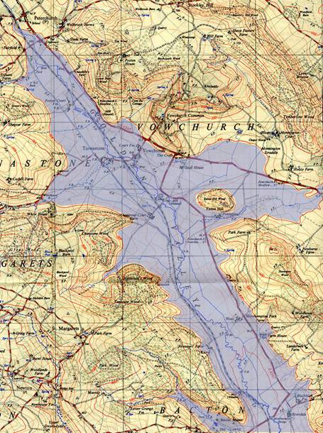
Many of the places to be mentioned will be familiar to some of you but for those not so familiar a map now will both define and introduce our area.
|
The area discussed |

The periods I will discuss are prehistoric, that is before documentary records. Much of the evidence is circumstantial. My views are from observation and personal interpretation. Many of my statements should be qualified by terms such as: ‘probably’, ‘possible’, ‘likely’, etc. but this would be pedantic and give a disjointed talk. I ask you to hold a set of such phrases and put them in where you will!
The defining feature of the area is the minor rivers and valleys. This side of the Black Mountains there are five river streams whilst immediately beyond the Welsh Border is another. All the streams generally flow from North West to south east. Working out wards from here we have the Dore; which rises above Dorstone and joins the Monnow below Pontrilas, The Dulas Brook is a tributary of the Dore and rises in Newton St Margarets. The Escley rises in Michaelchurch and flows down to join the Monnow at Longtown. The Monnow itself rises in Craswall and flows down through a long tortuous route to join the Wye at Monmouth town. The Olchon brook rises at the head of its valley and after about 4 miles joins the Monnow below Longtown. Just over the border the Honddu rises above Llanthony and after its initial southeast flow turns abruptly east before joining the Monnow at Allt-yr-Ynys and on to Llangua before resuming its southeast flow.
Each river or stream has its own character based on the geomorphic conditions under which it was formed.
Another most important feature is three moraines. One of these that at Llanvihangle is well documented;the other two, that at Corras in the valley of the Monnow and that which today separates the Golden Valley from its older course down the Grey Valley are I believe previously unreported. Moraines are formed by glaciers; they are large deposits of earth and stone known as glacial till and can completely block river valleys forming great banks which can become dams to hold back waters. These three substantial moraines would have been formed about 12,000 years ago when the local ice caps of the last Ice Age were at their maximum thickness and their glaciers at their most vigorous state. I hold that these moraines impounded a system of interconnected lakes which had at their maximum, a surface level at about 380 feet above the Ordnance Survey datum and is generally indicated by the 400 foot contour line on previous O.S. Maps.
River Hydraulics
A reminder of some basic hydraulics as applied to river stream flow.
- The speed or velocity of water in a channel or river bed is dependant upon the gradient of that bed
- Flowing water will either entrain or deposit solids depending on the particle size and the stream velocity.
- Entrained material will be transported down stream
- When the water velocity is reduced by either change in gradient or by flow into a larger body of water, such as a lake, suspended materials will be deposited.
Rivers and Valleys, their different profiles .
In my area of interest three different typical valley cross sections can be observed

Valley of Honddu
The letter ‘U’ Shaped valley. The classical shape resulting from a glacier. As seen in the Honddu and Olchon valleys.
Valley of the Dulas
The ‘V’ shaped valley. Typical of a geologically ‘young’ river valley. Young rivers have an appreciable bed gradient and the resultant rapid currents are actively eroding their beds and transporting material downstream. Seen in the valleys of the Upper Monnow, the Escley and the Dulas
|
|
Flat lands at Vowchurch | Flat lands at Abbey Dore |


The ‘Flat Bottomed’ valley as seen in the Dore, the middle parts of the Monnow (Clodock to Grosmont) and the lower Honddu.
My main interest today is in the third of these, the flat bottomed valleys. The flat bottoms are obviously alluvial in origin with deposited water borne solids. And the question to be examined is - are these alluvial deposits and the flat formations the result of river flood plains or from lake beds?
The different features of Lakes and Flood Plains
Both Lakes and Flood Plains can produce alluvial deposits which develop into flat lands. They have however distinguishing features which need consideration.
A lake has a surface level and shore line. This level, and shore position will change over time as a lake dries out. The water surface is flat but the depth can be variable and the bed not necessarily completely flat. A standing body of water such as a local lake requires something to hold it back. This can be a natural dam, a temporary blockage of ice or debris, or another body of water. Deposits brought into the lake tend to precipitate as soon as the water velocity reduces i.e. near the point of entry often giving a delta formation.
Flood plains are generally covered for a relatively short duration and alluvial deposits are small but repetitive. Floods are of differing intensity with only the lower lands being covered by the smaller floods, this gives a more effective levelling mechanism.
In many ways a lake is only a persistent flood plain. Lake beds and river flood plains are not mutually exclusive; indeed one could expect an exposed lake bed to later become a river flood plain.
What is to be expected is however in both cases is a wet boggy and marshy aftermath.
Floods
Even in present times these flat lands are subject to flooding. Perhaps two or three times a decade, in particularly wet periods, water can lay up to two feet deep. Motorists are often caught out. Invariably after the floods there is recrimination against the ‘Council’ or land owners who have allowed the man-made drainage systems to become choked and inefficient. Often action will be taken to clear drainage, but only to suffer further neglect.
Floods are generally at their worst in cold winter conditions when a snow fall quickly melts on frozen non absorbent ground.
One can only imagine what conditions were like in Post Glacial periods when melt water was abundant and mans’ drainage non existent.
Without mans’ imposed drainage these flat lands must then have been very wet and bog or marsh in their nature.
It is necessary to remind ourselves about Ice ages
|
A rather fanciful picture with perhaps excessive animal life |

Ice ages have occurred in a cyclic pattern over last 2.5 million years. They have an interval of about 120,000 years. Not all ice ages have the same severity. It used to be held that four different ice ages had existed, but modern research has now identified at least twenty.
The last ice age was relatively mild and peaked about 20,000 years before present. It finished about 12,000 years ago, - so global warming is nothing new.
The local extent of ice in the last age is shown in this general map[2] .

Global warming is quite rapid. We have only to remember that in April of 1912 a major iceberg in the Atlantic sank the Titanic. When was an Atlantic iceberg last reported? Glacier retreat in the Alps, Scandinavia and Alaska is now rapid.
We are now in an interglacial, that is between ice ages but there is no reason why an ice age should not return.
Profile of ice thickness over past time
In parts of the Artic and northern Russia where deep ice fields still exist, it has been possible to extract ice cores from deep bores. Data on the average temperature at which ice of different ages was formed can be obtained from analysis of these cores[3] .

Note the cyclic pattern with a general interval of 120 to140 thousand years between the peaks.
The cooling period is very long lasting for over 100 thousand years; warming when it comes, is relatively quick taking only a few thousand years. More time has been spent in ice ages than out of them, it is the ice age which is ‘normal’ and our own warm ‘interglacial’ exceptional.
Spikes on the temperature curves indicate short term variations which can be very important to the rate of ice formation and glacier flows.
Snow, its nature
Like many things in nature a snow crystal is a beautiful object. They are always hexagonal in form and have a fractal shape. This shape, chosen by nature, gives the maximum surface area to a unit of volume, which must be a key element in their formation. A small volume with a maximum surface area is optimum for the transfer of heat in cooling and the forming of crystals.
|
Snow Crystal |

Several crystals can interlock together and form a snow flake. This will have a low density with lots of air entrapped. giving good conditions for melting and refreezing.
Applying pressure to snow increases its melting point, and causes compaction, melting and refreezing. Remember the effect of foot prints and tyre marks on freshly fallen snow?
Depth of snow also causes pressure, with an increase in ice density as air is reduced, the colour of the ice then changes from white ice to blue ice.
Our concept of prevailing weather in an Ice Age
There is probably a misconception of the prevailing weather conditions are during an Ice Age. It would be wrong to imagine a perpetual blizzard. The day to day conditions were probably much like today, but slightly colder.
The annual snow fall may not have been excessive. A simple calculation will show that the flow in a small river equates to a large glacial ice front. Taking the river Dore at Vowchurch as our example.
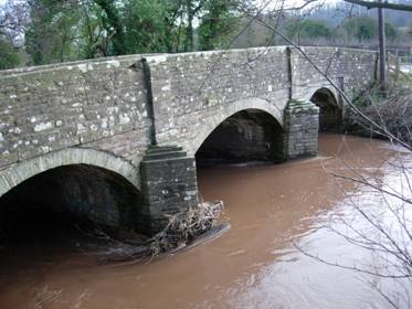
River Dore at Vowchurch
At times of modest flow the width can be estimated at about 20 feet, the depth 1 foot and the stream velocity as about 2 feet/second. If we accept the normal speed of a glacier to be about 5 feet/week, the water flowing in the Dore would be represented by a glacial ice front 500 feet high by 2 miles wide!
This is not to suggest that an ice front of this size actually existed. Even in the severest periods much of the precipitation would have fallen as rain with subsequent run off. However if just a fraction is added to the snow cap an appreciable ice front would have existed.
In general terms snow falls in the winter season and melts during the summer. If due to cold conditions the amount that falls in any year is greater than that melted, a build up of snow occurs on the high ground. With continual build up the depth and weight of snow on the high ground leads to movement of the underlying ice, that is there is an outflow of ice and glaciers are formed. Glaciers are driven by a combination of gravity and pressure and unlike water can flow up hill.
Effect of small fluctuations in mean temperature and ice melting rate
Ice caps are a balance between the amount of winter snow fall and the summer ice melt
If the snow fall is greater than the ice melt then the ice front of a glacier advances. If the fall less is than the melt, then the ice front retreats. If the snow fall broadly equals the ice melt the glacial ice front is stationary. However glacial flow continues and large terminal moraines can be formed at the ice front.
What can we expect to find later?
|
The area to be examined |

When a glacier advances in confined valleys there can be a sculpture action and rock faces become exposed. This is seen in areas of North Wales, the Lake District and the Yorkshire Dales but is not to be found in our part of the country.
In flat country there is less to be seen, some erratics are transported and the bulldozer effect of the advancing ice pushing material forward give terminal deposits in the form of moraines.
These moraines are largest at locations where there has been a stand still of the glacier front. It is important to remember that it is only the terminal front which stands still, not the ice flow itself, thus flow continues and feeds material to the moraine.
Along the edges of glaciers where the flow of ice runs alongside hilly ground, peripheral rivers can flow. These often leave a trail of washed gravel and esker ridges, features later exploited by man as gravel workings.
It is important to realise that it is only the final retreat that leaves deposits and visual remains, earlier fluctuations and deposits having been obliterated by later action.
There will be lots of water from the final melt stages causing extensive residual wet lands or lakes after the retreats.
These residual wet lands will endure for very long periods forming flat lands in an otherwise hilly terrain. Lake beds or flood plains will gather further alluvial deposits adding to the levelling effect. The flat lands will exist as wet boggy or marsh areas for very long periods until natural drainage is established, or until man intervenes. His interference is very slow and delayed.
The wet lands are not peculiar to Herefordshire; similar conditions extended over much of Britain.
Man’s drainage of marsh or bog is a very labour intensive process and well beyond the capacity of a single family unit. The work requires organisation, direction, and capital. It will be a very slow process, with little change over long periods.
The wet lands will form a major control factor in the settlement and use of the land.
How can we determine the probable extent of past lakebeds or flood plains? – What evidence is to be looked for? What settlement features are to be expected?
The evidence must be sought by observation and the careful study of large scale maps.
Firstly roads, modern roads have had their present surfaces for perhaps almost 100 years. Before that they had a metal of broken stone and earlier still were the tracks and ways of ancient traffic routes. Their position will be historical and a record of mans’ early choice in avoiding or skirting the wettest of ground.
The limited valley crossing points become important and will have gained strategic significance and can be the preferred sites for castles or fortifications.
Lakes can be expected to leave ’Shoreline’ features. A Shoreline is a feature which exists at one particular level and is linear in its nature. It can be a terrace with an edge of local steepness, caused by water wave erosion, where the land dipped into the water. Where a later road crosses a lake bed it will have to climb up at the old shore line. Here the road can be expected to be sunken with no, or only slight, verges.
There will be an absence of stone quarries due to alluvial overlay.
The wet areas will be avoided as locations for early habitation. They would have had an inhospitable and probably an unsanitary and unhealthy setting. The older sites of buildings will be absent due to poor foundation characteristics and lack of convenient source of stone as a building material. Springs as sources of fresh water will be absent.
Sites for early churches would have been chosen to avoid these areas for similar reasons.
The areas would have been avoided by early man. Neolithic, Bronze Age, Iron Age and sub-medieval sites of occupation are not to be expected.
The land in an undrained state will not support arable farming. Crops will not grow with their roots in wet soil. The lands and be of only limited use for seasonal grazing. These lands would not support families and as such it would not be suitable for allocation under the Norman feudal system which was based on Virgate grants and obligations to the Lord of the Manor. They thus remained undeveloped until post Conquest time. The lands would be ‘Waste’, that is rendering no profit, for a long period.
Tradition and place names may give clues.
Wet areas form natural barriers or boundaries and can lead to the separate and contrasting development of facing valley sides.
Conversely the high ground would be more important for occupation sites, Hill Forts, Camps and Ridgeway communication routes.
Areas of extensive flat lands occur at three places in southwest Herefordshire. The area around the lower Monnow valley, the areas around Pontrilas and the Golden Valley. When I came to prepare my notes for this talk I intended to speak in turn about each of them. However time will not permit this and I shall have to use only one of them as my example.
Looking at the evidence in the flat lands of the Golden Valley
The Prehistoric evidence
- Early habitations are absent from the flat lands. There are some prehistoric sites but these are on the high ground.
- The best known of the prehistoric monuments is the barrow called Arthur’s Stone. This is located significantly not only on a high eastern ridge but also above the village of Dorstone, itself at the top of the valley which would have been the first to drain and become habitable.

Arthur’s Stone
(image C Musson/ Woolhope Club)
- There was an Iron Age habitation site at Poston[4] . Here a promontory of high ground projects into the lower flat land.
- Flint scatters are an indication of sites of early habitation. There is a particular problem in identifying their distribution. To be noticed in the first place requires an observant person with willing access to a reportable authority. One such local authority of the mid 20th century was R. S. Gavin Robinson, a landowner of Poston, who had a well known interest in such matters. He identified several local sites, reported his findings in the Woolhope Transactions and made the telling comment that “Flint scatters are generally not found below the 700 foot contour and invariably close to a marsh”. Sites have been identified around Arthur’s Stone, on Stockley Hill, at Shegear, and on the Vagar Hill, all well away from the flat lands[5] . However, not all sites will have been identified and any on lower slopes could well have been covered by later deposits.
- There are three ancient standing stones in the area, two are on the higher western hills at Wern Derris and Mynydd-brith and one in the valley bottom, but at a roadside position above Dorstone on what would have been drier ground at a much earlier period. The purpose of these stones is open to speculation. Their sites had some special significance, do they mark some old burial, are they mere stones marking ancient boundaries or way markers? Who knows? But they were erected by early occupiers of the area and are a sign of early habitation.
|
|
|
Wern Derris | Mynydd Brith | Dorstone |


Prehistoric Locations
B- Barrow, C-Poston Camp, F- Flint site, S-Standing Stone
The later evidence
- It is very notable that the present day roads along the valley of the Dore skirt the valley sides rather than the bottom. Below Bacton the road is on the west side and in the upper valley along the east. In each case the roads follow the raised edge of the flat lands. In the section from Vowchurch to Peterchurch the road is actually along a raised terrace with a pronounced fall along its left hand edge. I suggest that this is a shore line feature.
The modern roads follow the course of much older tracks, themselves routed to avoid the lower flat lands that were unsuitable for traffic. It is also notable that the crossing from west to east is at Bacton on what was probably the site of a Roman Road crossing. The much more ancient route northwards from Ewyas Harold avoided the valley completely and followed the Ridgeway through the present Ewyas Harold Common and along via St Margarets, the Vager Hill, and on to the river crossing at Clifford. - There is a second valley crossing point lower down at Abbey Dore. This route was probably engineered by the monks of the Abbey to give a connection to their grange beyond Gilbert’s Hill.
- The road from Kingstone to Vowchurch goes over the Batcho Pass. As it climbs to the Batcho it is an obviously much engineered road. Falling from the Batcho it avoids the old settlement of Monnington and crosses the flatter lands which were owned by the Guys Hospital Estates and earlier by the Bridges and Chandos families. When this road was being ‘improved’ in the mid 18th century the local Justice representing the area at the Quarter Sessions and a Trustee of the turnpike trust; Mr William Wood of White House, campaigned vigorously and tried to have the route diverted via Monnington and the minor Holsty Pass because of the notorious condition of the ground which he alleged was impassable to wheeled traffic throughout winter[6] . This much older access to the Golden Valley was known as ‘Portum Straddle’ which interprets as the ‘Gateway to the Straddle Valley’.
- ‘Shoreline’ features can be seen. Particularly along the western side of the road from Vowchurch to Peterchuch and also at Bacton. Where minor roads and tracks climb out of the flat lands they are locally steep, sunken, and without significant verges
|
|
A ‘Shoreline’ Feature | Shoreline again |
|
|
Shoreline - Sunken Road at Bacton |
|


- Stone Quarries whilst frequent on the high ground are completely absent on the flat lands. The over burden of alluvial deposits make them impracticable.
- The Church at Peterchurch is again located at that elevation of 400 feet whilst that at Bacton is away from any centre of the parish but perched on an eminence again at an elevation of just over 400 feet. Both these church sites are old and probably date to pre Norman times. In the Monnow valley, Clodock Church is again at the 400 foot level.
- When we come to post Norman times we find a string of their Motte and Bailey castles, all strung out along the western side of the valley and each located above the valley floor. From the north we have Dorstone, Snodhill, Newcourt and Ewyas Harold. All command the lower wet lands but are all built on the slightly higher ground.

Locations, note how the later ‘historic’ sites are lower down in the valley
C-Castles, E -Earthworks
- There are three sites in the valley bottom that appear, at first sight, to contradict my hypothesis that the marsh flat lands were unsuitable for early occupation. These are the undated but probably early Norman earthworks at Monnington, Chanstone, and Turnastone. Monnington whilst well off modern roads, is strategically placed at the older entry to the Golden Valley, the Holsty Pass or as it was known in ancient days ’Portum Straddle’, moreover it is located at an elevation of just over 400 feet which as we shall see is a very significant level. The old earthwork at Chanstone is much lower and well into what would have been the wetlands; its form is however distinctive, a deep circular ditch surrounding a central mound. The ditch could be taken as a defensive feature but could equally be the excavation result of mans building of a dry mound for habitation above the bog level. At Turnastone the earthwork is again a raised mound, situated in the field behind the church and could have been for the same purpose.
|
|
|
Monnington Earthwork | Portum Straddle | Chanstone, Earthwork |


The Domesday Book evidence shows the lower Golden Valley as the limit of the pre-conquest Saxon penetration to the West. A map of Domesday Book place names shows this very effectively[7] , although there is some significant westward penetration in the northern end of the valley which would have been drier. The wetter lower valley was a very effective barrier to the Saxon’s penetration westward.
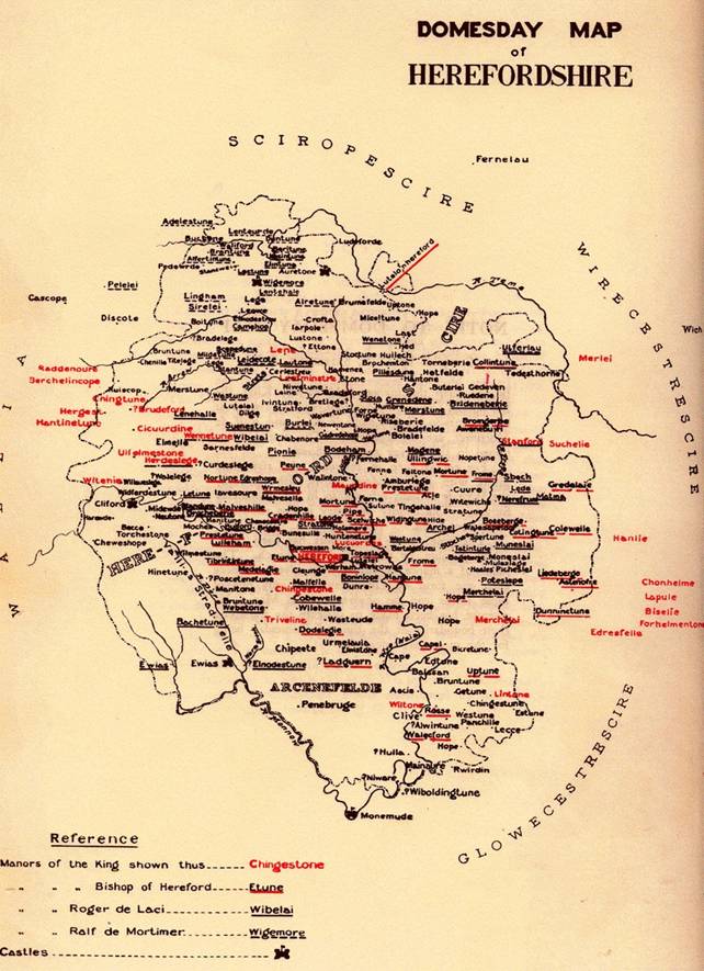
Places Named in Domesday
for more detail of this map click here
- The first large scale map of Herefordshire is that attributed to Christopher Saxton and dated 1577.[8]

This map is part of a remarkable achievement. Over a period of about 4 years Saxton produced maps of 34 counties of England and Wales. Although he is credited with much of the survey work he could not have done this work alone and acknowledges the help of others. As another put it “he had used his sickle on other men’s corn”. In many places the basic survey must have been filled in with second hand reports, perhaps often based on hearsay or oral tradition. I suspect that the depiction of a lake as the source of the River Dore may have had such an origin and is a throw back to earlier days when extensive bogs or marshes existed. Another map feature indicating the ‘Barrier’ nature of the valley is the juxtaposition of the two Deer Parks of Newcourt and Morehampton. Without a physical barrier to separate them, two adjoining deer parks are difficult to visualise.
- It has already been remarked that Newcourt, the centre of an early and large estate, is sited to the side and above the flat wet lands. As is the old manor house of Whitehouse, a daughter house of Newcourt, situated a mile or so higher up the valley. Whitehouse itself is sited at just over the 400 foot level and has the original name of ‘More’. A place name with the meaning of ‘Marshy land’.
- Morehampton, note again the ‘More’ element in the name, is an old holding of the Monks of Abbey Dore and important in the development of the eastern side of the valley[9] .
- The origin of the name ‘Golden Valley’ is accepted as being a corruption by the French speaking Normans of the valley of the Dwr. Dwr is the welsh for water. We have come to accept the word ‘Dore’ as referring to the river. But it may have been given in a literal sense as the valley of the Waters
- A feature of the flat lands is the Trench Royal.
|
|
Satellite image | A Lower Section of the Trench Royal ( image from Archenfield Archaeology Ltd) |


This is an ancient ditch that runs in a straight line for just over two miles from Chanstone in Vowchurch to Hinton just short of Peterchurch. It is generally attributed to the work of Rowland Vaughan and is suggested as having been done by him at the end of the 16th century. This is on the basis of a book he wrote about Water Meadows in 1605[10] . It is however most probably 200 years older and the work of the Monks of Abbey Dore and built by them to drain their estates in this area. The ditch is now much eroded but when built would have been about 10 feet wide and 4 feet deep. At its lower end it was considerably wider.
I suggest that the Trench Royal had nothing to do with Water Meadows and everything to do with land drainage and development.
It is interesting to speculate on how the undertaking of digging the Trench might have been organised and the amount of labour required. It would require vision to plan, control over the lands and the economic power to direct and support unskilled manual labour over a long period besides the necessary surveying and supervisory skills. All this would have been available to the monastic order, but not I suspect to Rowland Vaughan.
As an example of the amount of labour required, as a speculation, but based on my own experience in directing unskilled labour of construction work in undeveloped countries, I suggest that the work could have been organised by using working teams of 3 men, one to dig, one to move the excavated earth away and one for rotating relief. Progress at the rate of 6 yards per week per team might have been expected. To dig just over two miles, say 3600 yards, then 600 team weeks would be required. The work would by its nature be seasonal, with say 20 working weeks per year. If the work was to be completed in a realistic target of say 3 years then something like 10 teams of 3 men would be required, that is about 30 men plus supervision. These figures are not intended to be exact, but an indicator of the order of magnitude of the extent of labour required.
The Parrys, Vaughans, Bridges, and Woods were families that later exploited these lands.
Projected extent of Flat lands.
So were these flat lands the beds of lakes or formed by flood plains?
Looking at the evidence the 400 foot contour line seems to have a special significance and examination suggests that this was the approximate boundary of wetness and perhaps the extent of a post glacial lake system.
A lake with a surface level of 380 feet above the O.S. datum.
If lakes, then what held back the water? Perhaps more extensive waters? There are implications to the nature of the Hereford Plain.
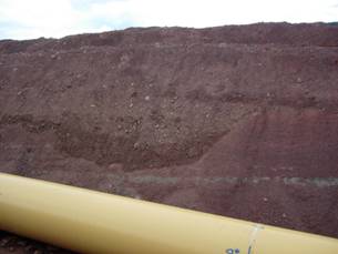
The 2007 Pipeline Project

Pipeline work at Vowchurch
You will be aware that last year a major gas pipeline was constructed from Pembrokeshire to Gloucestershire. Locally it came down the Golden Valley, its route following the flat lands I have spoken about. Opportunity was taken to watch the works particularly to see if the excavations could add any evidence to the geological formations which interest me. I was able to find such evidence at several places, the most important of which was the crossing of a long suspected moraine which today separates the Golden Valley from its earlier continuation down the Grey Valley. Here the excavated trench some 10 feet deep by six feet wide showed both by the excavated till and varving of lower deposits that this was of glacial origin and that the moraine had at one time held back what must have been an extensive post glacial lake with a surface level laying just under the 400 foot contour line.

At the approach to Batcho the Moraine is
shown on the horizon. It crosses the whole valley.
|
|
Pipeline crossing the Moraine | Trench and Glacial Till |
|
|
Section showing an old Cross Channel | Some well rounded stone |
|
|
Some collected Glacial pebbles |
|


How did ancient bogs and marshes become converted into today’s prime agricultural land? How was Commercial exploitation achieved?
In a word, by Drainage. Wet flat lands have great agricultural potential but need considerable resources in capital, labour and its organisational control for it to be realised.
Perhaps this was first provided on a large scale by religious orders in the form of abbeys. We know that in the twelfth century local Norman Lords gave tracts of land to monastic orders from France. Doing this was to their mutual advantage, it was a win-win situation. They gave lands which in an undeveloped state were of little value. The Lords gained amenable company, allies in adversity and perhaps the promise of a ticket to heaven! The monastic orders brought existing wealth, zeal, organisational ability and willing cheap labour to convert wet waste into productive land and the opportunity to increase the orders wealth and influence. Prior to the actual construction of their abbeys they must have done much preparation work in providing temporary accommodation, drainage work and the opening of quarries etc, all essential before embarking on the building of the Abbey.
The example provided by the Monastic Orders must have given impetus for some of the more astute local families to copy their working methods. This gave opportunities for certain families to become rich and powerful. Families such as the Parrys, Vaughans, Cecils, Scudamores, Hoskins, Bridges, Chandos, and others followed suit. And so large estates were able to be formed.
In time these estates become saleable assets, but estates beyond the pockets of small men, estates that could only be purchased on a national scale. They were attractive to the gentry as they provided privilege, income and comfort. Herefordshire has many of them. In the 1876 National Survey of Land Owners , Herefordshire was second only to Shropshire in having the greatest number of estates in the range of 1000 to 3000 acres[11] .
In Summary.
I have postulated that following the last Ice Age, in the period from approximately 11,000 to 1,000 years before present much of the low lands of southwest Herefordshire were poorly drained lake beds, marshes and bogs which took perhaps until the twelfth to fourteenth centuries to become habitable.
In earlier times this formation may have extended across much of the Herefordshire plain.
The Herefordshire Plain
[1] Sidney & Beatrice Webb, English Local Government; Statutory Authorities , 1922, p13
[2] British Regional Geology, The Welsh Borderland , 2nd edition,1948, p76
[3] http://www.uwsp.edu/geo/faculty/lemke/geog101/lecture_outlines/25_the_ice_age.html
[4] Anthony, I.E. ( 1958), The Iron Age Camp at Poston, Woolhope Club
[5] A. E. Brown, WNFC Transactions 1961 and Flint Collection with notes at the Hereford City Museum.
[6] H.R.O. F37, Whitehouse Papers
[7] J Horace Round, Introduction to the Herefordshire Domesday in The Victoria History of the County of Hereford , volume 1, 1908
[8] Smith, Brian S. (2004). Herefordshire Maps 1577 to 1800 .
[9] D.H. Williams, White Monks in Gwent and the Border ,1976
[10] Rowland Vaughan, His Booke , 1610
[11] Parliamentary publication, The Returns of the Owners of Land , 1876
Ref: gc_gdv_3000