
Title: | An Historie of Cressewelle and Yonder, by Ruth Watkins |
Date: | Geological time to present |
Guest contribution: Introduction
We are indebted to Ruth Watkins for permission to publish her overview of the history of Craswall. It was written as an introductory booklet for visitors to the area staying at holiday cottages on Dukes Farm. It gives an intimate personal perspective on the landscape, geology, agriculture, rural economy and history of the area as well as pointing to places of local interest. The focus on Dukes Farm is also a valuable point of reference for understanding how the broad sweep of historical change has impacted on local farmers and the community over the years.
Ewyas Lacy Study Group
An Historie of
Cressewelle
& Yonder
or, ‘What we did in the long, dark nights.’
With thanks to all the authors I have quoted, and to friends & family who have taken an interest and supported me. And to whosoever is reading now, thank you too, for without your eyes, it liveth not.
Contents
Craswall in brief
The Geological Drama
Hallo, human
The fleeting Bronze Age
The Prehistoric Puzzle ...
The Marauding Iron Age
Craswall’s Farmhouses
Politics again: the Act of Union
The Golden Age of Agriculture
The White Noise of Recorded Time
The Tarnish of that Golden Age
Our Fifteen Minutes of Fame
What is Craswall like now?
Bibliography & notes
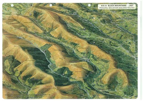
Figure 1 A topographical map of the Black Mountains
Craswall in brief
Craswall’s chief distinguishing feature is its topography. The River Monnow rises in the Red Dingle in the north of the parish, is joined from the northeast by a brook called Cwm Candy, then runs down our steep narrow valley, growing fast as it gathers the waters running off the Black Mountains, and away into Gwent. The valley lies between and parallel to two other similar valleys, the Olchon and Escley, an alignment which lends a kind of democracy. These three valleys contain separate parishes – Llanveynoe, Craswall, and Michaelchurch - yet we feel bound and befriended, attending each others’ fetes, funerals and whist drives. But unlike the parishes in those neighbouring valleys, Craswall has no manse. We never had ‘a big house’, a squire, nor a rector to doff our hats to, or more to the point, we had no endowments to embellish the church. Craswall has always been a plain unpretentious place with a church to match.
The Hand of the Black Mountains
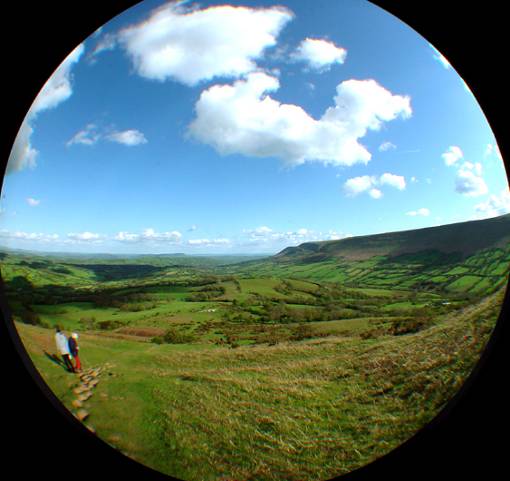
We Craswallites identify strongly with the mountain to our south-west - it gives us our backdrop, our weather, our stories, our whole context. Rising to 640m and called Crib y Garth or Black Hill on the local OL13 Ordnance Survey map, we all know it as the Cats Back. It is the most easterly ridge of the Black Mountains, which, it has oft been noted, take the shape of a hand. If you put your right hand palm facing down, fingers to the south, there you have the Black Mountains’ ridges. The River Usk flows along the outside of the little finger, around the two hills that harbour Llangorse Lake - Mynnydd Troed and Mynnydd Llangorse - and it divides us from the great shouldering heights of the Brecon Beacons. From the west, between fingers as it were, run the rivers Fawr, Fechan and Honddu. The Olchon Brook lies in the blind valley contained by the thumb, and Craswall lies the furthest East, at the head of the Monnow river, along the outside of the thumb.
That’s our geography, what of our history?
Well, it is pretty distinctive because we have changed hands not once, but twice. Man ventured up the Wye valley forty to sixty thousand years ago, spreading out into the hills as his fortunes waxed and waned. As he learned to use the resources round him – wood, stone, animals, metals – he flourished, and left more and more signs of his presence. He left tools, debris and earthworks, but most visible are our tracks and green lanes, many of which are still used to this day.
‘Wales’ means ‘stranger’
The words ‘Wales’ and ‘Welsh’ come from the Saxon for ‘other’ or ‘stranger’, and were applied to remote territory and its small, dark indigenous peoples as they were driven west by more mobile and aggressive populations arriving from the east. The natural barriers of the Rivers Severn and Wye formed the border with England, so everyone west of there was Welsh, and in Wales. The old Celtic culture remained through the long Dark Ages. They were tumultuous times for this island, so our quiet, secretive hills became a refuge for Christian hermits and teachers. This area must have been safe because their sanctums are mostly on promontories, junctions and river crossings – places to be found, not hidden. It became a seedbed for saints; church patrons and parish names are still derived from those of unfamiliar Celtic holy men – St Clydawg, St Issui, St Bueno, St Dyfrig. It’s easy to imagine that this holy period ushered in an aura of stillness and hush that remains to this day.
Then the Normans forced ‘the March’ upon us, a brutal frontier state with laws unto itself. For five hundred years, the March existed as a political and legal entity. Monastic Christianity became the major economic force, rogue lords our rulers. Our geography was lucky for us, with springs issuing from the rock in secluded places, and outcrops forcing surprising turns of the road. The natives could keep a low profile, secretively establishing homesteads along tracks, away from view, grateful for the small mercies of a quiet life. This area remains intimate, with small fields and narrow lanes closed in high hedges. A close dignity still prevails.
In 1536, after almost five hundred years of the March, when Henry VIII was in a bate about his harlot queen, he instructed his bold English geographers to abolish all the Marches. They slashed a new border, right down the first finger of our Black Mountain hand, slicing our Monnow valley and the small blind valley of Olchon into England. All in a day. They dished us up on different plate, and there we’ve stayed. This arbitrary stroke of fortune forced folk to turn in on their own resources. Look down, say nothing, get on. Their connection firmed with the land itself rather than outside authority. No wonder the people here became self reliant, cautious, and very able.
The Recent Past
But by then we had a cash crop: wool. It was the making of us. It returned cash to the area year after year to build houses, barns & villages. By the start of the nineteenth century, food was needed in abundance for the rapidly growing urban populations during the Industrial Revolution, so farming was on a roll when Ken’s family came to the area over 200 years ago. Later that century, we suffered as world trade grew to include food imports. The first half of the twentieth century gave agriculture new significance during two World Wars. The tables have turned on farming again now food is easily come by, imported in great abundance. The countryside has been forced to take on a different slant. It needs to be entertaining; and farming relies on the likes of Adam Henson, Kate Humble and Greg Wallace to win support.
The Geological Drama
The Devonian period
Both our local mountain blocks, the Black Mountains and the Brecon Beacons, are made of Old Red Sandstone, formed in the Devonian period four hundred million years ago. They were part of a small(ish) landmass called Avalonia.
Their formation in Avalonia happened six thousand miles away; way, way below the Equator around the Tropic of Capricorn - about where southern Angola is. A global village then as now. Stormy attrition wore the featureless rock into smooth grains and striated layers over aeons. It was the ebb and flow of weather then that gave our bedrock its shape now, that makes it versatile for its many building uses. It is variously deep for walls, flat for floors, thin and hard for roofs. I like to think of the stone surrounding us all coming from that single source: the stone in the walls around us, the tiles on our roof, and the flagstones we walk on – we’re encased in it. If you walk upon a quarry or some freshly riven stone, you will see the rippled surface of a desert revealed for the first time in four hundred million years.
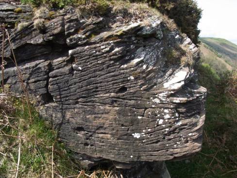
Figure 2 The Devonian bedrock
Tectonic movement drove Avalonia north until it collided with Laurentia (southern Scotland), forming a chain of fold mountains that rivalled the Himalayas for height. The Devonian period ended when the ice sheets melted at the South Pole and the waters covered the earth. Avalonia/Laurentia, now a single landmass, continued to move north. Having been ground down in the desert – literally – by the weather, these huge Caledonian mountains now lay under shallow tropical seas on the equator.
The Silurian Era
During this foreign holiday, the equatorial heat drove off water to form two other rock types that were the making of our area. First, evaporite limestone bands were laid down. If you look south up the wooded hill from Hay car park, you can see a white outcrop in the woods. It’s called Hen Allt [i] , and is a cliff of pure limestone. Another more common but less pure form of this limestone is marl, which is a natural concretion of clay and carbonate of lime. It’s pinkish and lumpy, much like concrete. There is a lot of it in the stones and paths around Dukes Farm – the path in the water garden, for instance, and the cobblestones, locally called pitching, across the yard.
Our Limestone Cowboys
Heated to break down and purify the lime content, limestone and marl were invaluable for the staple industries of the area: building and agriculture. The lime was pounded into mortar to fix walling stone together, and it was also spread on the fields to alleviate the high acidity of our soils. Kilns were built close beside outcrops of marl; there are vestiges of lime kilns at each end of the wooded river bank below Dukes Farm. There are two on the outside of a sharp right hand bend on the Craswall road to Hay (OL13 253 389), and the ice cream farm, Rowlestone Court[ii] has splendid intact kilns on their woodland walk, worthy of listing.
A Raw Deal?
Although our mountain (and here in Craswall we refer to it in the singular as ‘the mountain’) might look dark and forbidding from the East with the sun behind it, (hence the English name ‘Black Mountains’), it is far from that to us. We lie in its rain shadow, with substantially less rain than the western side, and often watch the clouds held back by the ridge. They roll towards us then disperse in a gentle drama. And on an east wind, we feel equally blessed. You can hear the Arctic whistle as the mountain lifts the icy blast over Craswall, leaving us with still, bright air. So the mountain protects us, and inspires us when we peg out the wash, or pick peas. Sometimes you can almost see it breathing.
Our great Black Mountain goddess had settled down, and only had four Ice Ages to endure, the last of which covered almost all of Wales, and left Herefordshire rocky up top but boggy in the bottoms. Boggy but fertile, ripe for agriculture.
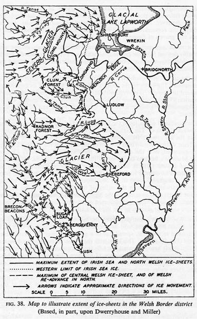
Figure 3 The Glaciation of Wales from British Regional Geology: the Welsh Borderland, HMSO 1948
Hallo, human
There was human habitation in caves on the Banks of the River Wye from sixty to forty thousand years ago. Stone axes found in the Lugg and Monnow valleys suggest early man travelled to hunt, and by Mesolithic times he was leaving flint blades, scrapers and shards at many sites round the Black Mountains
In People of the Black Mountains , Raymond Williams imagines that around 7000BC,
Over three thousand years, in a country becoming kinder, the hunting continued but the small families living at the very edge of survival had grown and extended until they were large and prosperous, each with its own hunting district.
This is when our uplands became continuously inhabited, when Mesolithic man settled in permanent territory. And his brains thrived on all that meat.
An oxymoron: the ‘New’ Stone Age...
Around six thousand years ago, Mesolithic Man figured out how to pleach a hedge, build walls, or erect a stockade, and trap his herd within. He became a farmer. Eventually he learned how to preserve food for his animals as well as his tribe to see them through the winter. He made hay. By 4500BC, Neolithic Man had settled down hereabouts permanently. A large Neolithic community spread out from its base in the Dore valley just east of here, establishing satellite tribal bases in Olchon and our upper Monnow valleys. It was a Golden Age in the Golden Valley.
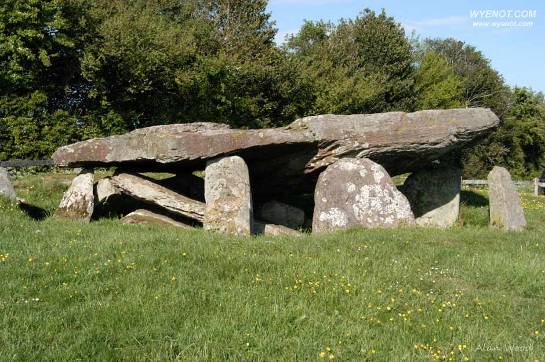
Figure 4
Arthur’s Stone
... and its passion for funerals
Neolithic man left us Arthur’s Stone[iii] . This is a fine example of a passage grave, a doughnut-shaped circular structure that would have had a communal bone sanctuary at its centre. The whole thing was covered over with a grassy mound that at some time has been removed.
The large Neolithic settlement in the Golden Valley associated with Arthur’s Stone is flattened over and farmed, but the finds there - thousands of flint fragments, fifty polished axes, storage pits and stone walls - they indicate a resident community of two hundred and fifty people at its peak. Huge when you consider that today’s nearby villages of Dorstone and Peterchurch are both smaller than that.
3000 BC - What was our valley like then?
This settlement would have generated satellite communities, comings & goings. Our valleys were criss-crossed by tracks, populated by family groups, smoke rising from settlements among the trees. An enduring culture like this would have had rituals to observe, memories to enshrine, events to celebrate, and countless tales to tell round the fire.
The Big Neolithic Question
Among all this speculation, an important question occurs to me: when did Craswall Man see his first sheep? Probably about now. Sheep migrated across with early farmers from the Middle East, some claim before the land bridge across the English Channel was finally washed away in about 4600BC. They were brown and horned, and moulted annually like Soay sheep. (It’s called ‘pelling’ when sheep lose their fleece before they are shorn.) By about 3500BC man had learned to spin, so yarn and cloth became another aid to survival.
On the Cefn Hill[iv] just north of here at the head of the Monnow valley, spindle whorls have been found, our first clue that about the third millennium BC, Craswall Man had met those annoying woolly jumpers that have moulded his destiny ever since. A sandstone mortar was also found, so Craswall Woman was also hard at it, preparing food as we have done ever since. And several cremation pits. Bodies were not burned in these pits, but after cremation, remaining bone fragments were gathered up, and added to communal remains in pits or urns.
At the cutting edge of archaeology
One of British archaeology’s recent big finds is in the tiny Olchon valley just west of here. In 2011, a big dig unearthed a complex (i.e. built and over-built in several phases) circular structure with an intriguing pattern of cremation pits and two earthenware beakers at its heart. In one of these, bone from at least two individuals was found, and in the other, fragments were layered according to type; vertebrae, long bones, digits etc. The rituals of our Neolithic ancestors were clearly complex and meaningful.
|
|
| Figure 5 Olchon passage burial beakers photo courtesy of Hereford Museum |
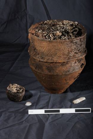
What makes the find especially exciting is that less than a quarter of a mile away is another burial of a completely different kind. A farmer ploughing in 1920 uncovered a cist (pronounced ‘kissed’), the stone-lined grave called of a young man, aged 25-30, buried in a crouched foetal position, aligned N-S, with a single beaker and a tanged spearhead at his feet. Carbon dating confirmed the date of this burial as circa 2000BC – early Bronze Age.
While ploughing in 1984, another farmer, our own Ken Watkins, turned up an identical cist here at Dukes Farm (grid ref: OL13 298 353) To see it, walk up to the furthest field at the North of the farm, where it’s about 15 feet from the top fence, 40 yards into the field.
Dukes Farm’s cist was empty but for a few mouse bones, probably robbed of its funerary urn and grave goods, the bones tossed over the hedge. When you see it, you might be underwhelmed – it is simply a stone-lined hole in the ground about 2ft by 3ft - until you remember what a rare and venerable piece of prehistory it is – and still in situ . It contained a single warrior king, curled up as he came into the world, carefully aligned North-South in his grave. Who knows what rage and defeat surrounded its digging? Who knows how long and elaborate the ceremony to place him there, how large was the stone that covered him, how significant the decoration, how oft his kith and kin returned to remember him? Who can imagine how they honoured this king with their stories, what strength they derived from it, and for how many generations those stories endured? Look around at the mountain and the glaciated hills of Herefordshire like humpback whales, the hills of Radnorshire, Worcestershire and Shropshire that lie beyond. It is a chosen spot.
Who knows, too, how many more warrior kings still lie in the landscape: the archaeologists reckon the small tumps in the field are probably other cists ...
Two different burial practices so close together. What could it mean?
The Olchon communal grave predates the cists by possibly less than a thousand years, so in very close proximity we have a communal passage grave used over a long period, with many burned bones buried together on various occasions, and at least two cists, each containing a single warrior. Could there be a neighbouring tribe just across the road? With a different funeral director? No, it means the valleys here were inhabited for millennia, at the cusp of two very different eras of Man.
The fleeting Bronze Age
The Stone Ages were interminably long compared to what followed: the Bronze Age. Man made a great leap forward in discovering metals that he could extract, mix, mould and hammer. Trade enjoyed a step-change. Strange new practices overlaid traditions that had lasted aeons.
The Age of Stone suddenly gave way to an Age of Metal, of prized objects and elite individuals, whose zenith was a kingly culture with metal crown. Changed rituals are a big clue that it happened quite suddenly around four thousand years ago. Group burial gave way to burial of an elite - male & female - with their regalia. The proximity in both time and locality of burial sites in the Olchon and Craswall valleys and on the Cefn Hill is a stunning illustration of this rapid change when communal burial became oh-so-yesterday. Our Bronze Age burial cist, those excavated in the Olchon valley, and others speculated to lie in this landscape; they each contained a hero!
|
|

Another clue to rapid change is the differing style of beakers. Although that which accompanied the king’s burial in the Olchon valley was empty, it is significant because in its style, it imitates the Beaker People’s beakers. In it, anthropologists see a deep shift in culture. They see it indicating a new aspirational culture in which exotic goods became prized by an elite. The start of fashion, if you like.
|
|

|
|
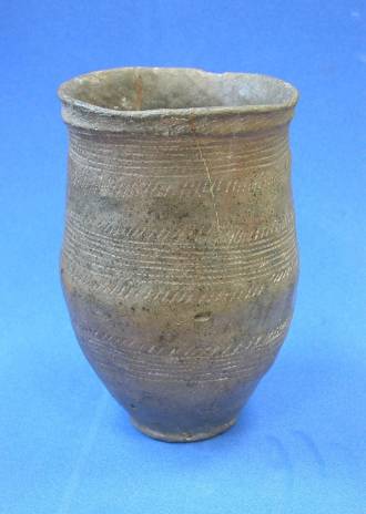
Figure 6 Olchon cist burial beaker: Photo courtesy of Hereford Museum
Funnily enough, we still recognise this polarity of ideas in and around Craswall. We use the phrase ‘from off’ about people who come here from somewhere else, separated by distance and difference. Unlike the Cornish ‘grockles’, the phrase ‘from off’ does not attach itself to tourists or visitors, only to people who come ‘from off’ – London, Walsall, Norwich, say - to settle. On the one hand, it may seem a slightly dismissive phrase, ever so slightly suspicious of the potential to bring new ideas, but in holding new ideas at arm’s length, it has a positive role in respecting and protecting what is already here. Fashion can be a tawdry business. (I was ‘from off’ - a dairy farm near Stratford-on-Avon - when Ken married me, and believe you me, it sometimes still feels true.)
700BC – What was our valley like then?
All this tells us that our forbears were living in this upland landscape through times of great change. Although he had vital new materials, Bronze Age man stayed put. His communities were geographically continuous with those of his Neolithic forbears: the sites, the routes, the intervisibility with the mountain remained - our own cist is just a quarter mile from the Cefn Hill Neolithic cluster. The mountain was still important to him.
The Prehistoric Puzzle ...
Early man has become known for his elaborate burials containing ritual goods, whether they contained group remains or single heroes. But he left a bit of a puzzle for us: why are the clusters of Mesolithic, Neolithic and Bronze Age settlements gathered around the Black Mountains – where it is high, wet and windy?
The current theory is that proximity to the mountain (or the sea in Pembrokeshire) conferred identity. The mountain was always in view. It was a visual magnet, the focus of a religious and symbolic life. Archaeologists and anthropologists liken its appeal to the sacred land rites of other aboriginal peoples.
The view from our Dukes Farm cist may have persuaded you of this, but a trip to Arthur’s Stone (opp. cit) adds real weight to the theory. The layout of that burial chamber is unique. If you walk out of the chamber between the stones that mark the passage, (remembering that the whole lot would have been covered by an earthen mound) you’ll see how it turns west to face Hay Bluff. Easy to imagine, then, that having opened up the barrow to add bones to other ancestral bones, the ceremonial return to life turned to face the unchanging, protective hill.
Ways and rhiws
Imagine the toing and froing over four thousand years that made our deep green lanes. If you walk the Top Road [v] that runs along the tree line below the mountain, or go to the top of the farm to see the vestiges of the Cefn Road [vi] along the ridge, or look across the valley at the visible diagonal tracks leading up to the ridge of the Black Hill, you will see the ways of Neolithic Man. These age-old straight tracks over the mountain still retain their Welsh name: rhiw (‘roo’ as in kanga-roo).
Allow me to introduce our first local hero …
Alfred Watkins (no relation) 1855 – 1935 was
“a bit of a rough diamond to look at. Broad-shouldered and bearded, he wore (winter and summer) suits of Harris Tweed lined with grey flannel, containing fourteen pockets. These pockets were filled with letters, pamphlets, tools, rulers and other paraphernalia. When the coat was almost too heavy to lift, he would empty the content in a heap on the table in his den. This room was a scene of apparent chaos, but he could always find everything he wanted.”
He pursued his love of the Welsh Border and Herefordshire with extraordinary energy; much of the locality’s early photographic record is his work. His intimate knowledge of the countryside led him to the revelation for which he is best known: a theory about early man’s methods of navigation and route-finding based on tracks called ‘ley lines’. He thought these were linked by visible markers in the landscape, and he threw himself into identifying these, and writing it all down in The Old Straight Track.
Among the visible points identified by Watkins are the ancient stones in Vowchurch churchyard( OL13 363/365), at the Red Lion pub in Madley (Landranger 149 419/389), and the market stone in Grosmont market square (Explorer 189 345/243) . He saw alignment in the fords at Clodock (OL13 327/275) and Olchon (OL13 274/337), in the notches in the mountain at Trewyn Camp (OL13 322/230), and Rhiw Arw (OL13 307/270), and he ascribed waymarking significance to the old churchyard crosses at Hentland (Explorer 189 543/264) , Capel y Ffin and Vowchurch.
Many of them are later Christian and civic landmarks, and Watkins’ theory is pretty well rubbished in academic circles now. But nevertheless, The Old Straight Track describes geographical continuity very well. The Christian and civic sites were chosen because they had longstanding significance in the landscape. It can turn our ideas about prehistory on their heads. Instead of thinking of prehistoric man inhabiting another world, a quaint and naïve one, we become servants of their geography, compelled by their moulding of the landscape to superimpose our structures on theirs. They etched a landscape so deep that we merely acquiesce.
The brevity of their lives
With its young warriors entombed, the thing which the local cists remind us most forcibly, something it is easy with our three-score-years-and-ten mentality to forget is how young were the men and women who built these communities, dolmen and cists. Bronze Age life expectancy was about thirty. Folk would have bred as soon as they reached sexual maturity. Today’s university student and tattooed goth would have been architect, project manager and grafter at Arthur’s Stone.
The Marauding Iron Age
The Bronze Age was fleeting because no sooner had European man discovered copper and tin than he began mining and trading in another stronger metal, iron; and another more beautiful and enduring one, gold.
But life changed for another reason too: the climate deteriorated. After at least four thousand years of continuous habitation, the uplands became much colder and wetter. Famine and disease were commonplace. By 700BC, our local dwellings were largely abandoned. Most archaeological evidence moves to the Iron Age hill forts of lowland Herefordshire. The built structures from which we derive our knowledge are no longer burial mounds and chambers, but fortified settlements. There are well over fifty hill forts in Herefordshire and masses more on the Welsh side of the mountain, but only four of them are in the upper Monnow and Golden valleys.
Corn, not horn ...
Man’s focus changed. Being close to & within sight of the mountain ceased to be important. Richer land for cultivation was: Iron Agers became crop farmers with less reliance on ranging territory for herding and grazing. Valleys were too damp to cultivate and too hard to defend. It was hills, especially the low fertile hills of glacial deposits, which were preferred over our marginal uplands.
... and war!
Fortification became very important. Using very little equipment, communities poured enormous effort (they were young, remember) into building massive wood and stone-walled settlements set on circular earthen ramparts. They were defensive earthworks so huge that they remain to this day. Who were they defending themselves against? Themselves; at least, their Iron Age neighbours. That kingly culture cultivated a competitive spirit. Vengeful raiding served as entertainment, banking exchange, and dating agency. These were the hostile Britons that the Romans found when they arrived, and they endured in a modified form after the legions left.
I like to think that our most local Iron Age site at Poston[vii] gives an interesting clue to local character. Upon excavation, the range of artefacts found there was unusually broad, chronologically. A mix of bone, bronze and iron items co-existed, with wool-spinning whorls predominating over tools of war and rank. We needed to work to keep warm, and we didn’t like throwing useful stuff out. Wool must have provided crucial comfort in a world of skins, leather, even nettle cloth. More telling and almost unique among communities from that era, an Iron Age burial mound was found at Poston’s fort. Most importantly, there was no evidence of conflict. These idiosyncrasies suggest that change came slowly here, people carried on the old ways longer and more peaceably while new ways were absorbed and grafted on.
It was the island the Romans found when they came in AD48.
The Roman road builders
The Romans tramped up the Wye and Usk valleys, east & west of the mountain, they mined iron ore in the Forest of Dean, and smelted it in Abergavenny (Gobannium), Monmouth (Blestium) and Weston-under-Penyard (Ariconium). The road between Gobannium and Magni Castra was called Stoney Street. It passed through Madley, and a bit was uncovered when they built Abbeydore train station, but no-one bothered to save it. The main significance of Roman roads for the likes of us was for collecting taxes.
Apart from the road through Abbeydore, no trace remains. We were very much on the fringes. Our local Poston Iron-Agers went about their business, offering up what tribute was demanded of them whilst sticking to the old ways, and shrugging at news of things beyond the stockade that barely concerned them.
The Roman legacy remains
But the Romans did leave several important legacies (apart from oats, walnuts, chickens, rabbits, roses, lilies, vines, etcetera, etcetera …). First, they Christianised a few of us. Secondly, they wrote about us – though in a paternalistic moralising way – and they gave us an alphabet and taught us to write. What we know of the following centuries comes mainly from the writings of Geraldus Cambriensis and the Book of Llandaff. Warning: when we read them, we need to remember that they both had an anti-pagan axe to grind.
We get a name: Ewyas
Thanks to the regulating effect of Roman taxes, life was more organised. Celtic Britain’s tribal territories or kingdoms were finally chronicled and named. We were at the northern tip of the territory they named Ewyas, which, along with Ergyng to the south and east, and Tewdos to the north and west, ran from above Hay down the east side of the Black Mountains, and stretched across to the River Wye at Ross. Ergyng derives from the Old English ‘urchin’: hedgehog, but expert opinion divides on whether Ewyas is a derivation of ‘ewe’, a female sheep, or ‘ywen’, the Welsh for yew. We were either ‘Sheep Country’ or ‘Yew Country’. With the fields full of sheep and the hedges full of yew, both are perfectly plausible.
It is very unlikely that this part of Ewyas, this valley, was called Craswall – that is a later name. There is no record, but as the Welsh are prosaic in their naming, my guess is Penmynwy ‘the head of the River Monnow’. Our local routes were not Romanised, and would have continued to follow the contours, the natural pull of the landscape. People followed the old ridge roads, and events probably gravitated towards the flatter lands of Clodock, Walterstone, and Pandy, towards Abergavenny and Monmouth.
340AD - What was Craswall like then?
The domestic hen – a Roman import – may have been scratching in the dust, competing for morsels with our native ducks and geese. We were growing subsistence quantities of oats, rye and wheat. Our herds of indigenous small black cattle, and pigs domesticated from the wild were grazing alongside sheep. The Romans had introduced white polled sheep, which crossed with the Soay are thought to be the origin of our familiar Welsh mountain sheep. The small brown sheep of the Bronze Age were probably getting paler and larger. Maybe the new sheep didn’t moult, so Craswall Man had to pluck or cut the wool? If so, things are starting to look familiar...
|
|
| Figure 7: Ken shearing, Lassie helping |

Eastern Wales – the cradle of saints
By the end of the Roman Empire in 476AD, the European Christian hierarchy was already abusing its power, which led to a counter-movement of holy men & hermits across the continent. During stable periods of the Dark Ages, early monks and hermits settled far and wide in Europe, wherever they found acceptance, which they did among the Celts. These isolated hills of eastern Wales were too far east for the warring Welsh, too far west for the heathen Saxons – and truth be told, too hilly for easy pickings. They proved a safe haven for hermits, and thus became a seedbed for Celtic saints.
Welsh clasau
Local chieftains granted these holy men safe haven to establish a religious sanctuary called a clas (whence the word cloister derives). The holy man, whether home-grown or migrant, would choose a piece of land, possibly already locally significant to a pagan people; a spring, a crossing or an outcrop, to build a timber or wattle and daub building. Over time, this would become clustered round with huts or cells where acolytes lived. Eventually, the whole was enclosed within a circular stockade, and if the project flourished, a stone church might be built, bearing the name of the founding holy man, canonised to sainthood. Its origins as a clas on an earlier pagan site is the reason early circular churchyards are presumed to be pre-Christian.
Finally, a more plausible story –
There are a number of local churches on sites of early Celtic clasau , most notably the tiny church at Llanveynoe[viii] in the Olchon valley, dedicated to St Bueno. He was granted lands there by a grateful King Ynyr of Gwent who became his disciple after being cured by the holy man of some leprous disease. Although St Bueno later left the area to become venerated in the wider Celtic Christian world, the church remains. The building now stands in a small fenced square of churchyard, but recent excavations show it was originally set in a much larger circular compound that marks it out as beginning life as a native Welsh monastery or clas . Llanveynoe church has very ancient crosses dating from this time. There are two cross inscribed stones set in the wall inside the church, and a standing stone outside the church just to the right of the porch. It has a deep libation groove carved the length of it, a sure sign of pre-Christian pagan practises.
Much of this flowering of Christianity happened in the settled years after King Arthur had defeated the Saxons at the second battle of Badon in 516. It was a temporary respite in several dark centuries of war after the Romans left.
King Offa
Notable in this time was King Offa, a wily old Saxon who ruled for an impressive thirty eight years; from 758 to 796AD. He wisely married two of his daughters to the kings of Northumbria and Wessex, so via his son-in-laws he straddled Britain with enough power to drive the Welsh border west and fix the boundary in his favour with a huge forty-foot dyke. An earlier king called Wat had given him the idea by building a short length of ditch and rampart in North Wales, but Offa really dug in to the extent that despite roads, farming and the attrition of time, his Dyke still stands forty foot high in places – notably near Knighton and Symonds Yat.
The Dyke is not the Footpath
Offa’s Dyke is not to be confused with Offa’s Dyke Footpath. This is a one hundred and seventy mile Tourist Board trail created in the 1960s, following the Welsh border through the Black Mountains. The Pandy to Hay stretch [ix] runs along Hatterall Hill above Clodock then atop the Darren, which is the second ridge visible from Dukes Farm. It carries on along the ridge over Hay Bluff and through farmland into the town of Hay-on-Wye itself. The real eighth century dyke runs well east of here from Kington through the black and white villages to Hereford. The foothills of the Black Mountains were very definitely on the Welsh side!
War, war, and more war
Not only were the Welsh raiding eastward to drive the border back to the Severn, with the Saxon English determined to fix it west of the Wye, but to make matters worse, the Vikings pitched in from the eastern seaboard. Mostly north of here, the next couple of hundred years roll out like a Playstation epic involving kings in scratchy clothing who couldn’t spell their names: names like Eadgar, Aethelwulf, Cnut.
King Hywell Dda gets bureaucratic
Gradually, these wars and alliances wrought England into a shape we’d recognise with kingdoms of Anglia, Mercia, Wessex. In Wales, kingdoms joined forces to survive. By 944AD, King Hywel Dda had formalised the old tribal territories into a complex hierarchy. Ewyas became a commote (from the middle Welsh cwmwt) - and the four commotes of Talgarth, Yrchenfelde, Ewyas and Crickhowell, made up the cantref of Gwent. Along with the rest of Wales, we were subject to the law of gavelkind under which rent was payable in goods or produce rather than money, and a deceased person's land was divided equally among all male heirs. Eventually, Gwent and Glamorgan were also united.
This civic structure makes it all sound very orderly, but them ol’ Welsh remained a problem to the English. Edward the Confessor (son of Ethelred the Unready, and two hundred years earlier than Edward the First – confusing, no?) came to the throne in 1042, and was thoroughly fed up with the truculent folk across Offa’s Dyke. That defensive earthwork cannot have been doing its job. Spending all his young life in Normandy with his Norman mother, Edward was a Norman at heart. He hit on the idea of inviting his nastiest Norman nephew, Ralph, to become Earl of Hereford.
Earl Ralph of Hereford and his Norman chum Osbern Pentecost built the first two Norman castles in Britain over twenty years before the Norman invasion of 1066. They sited them strategically at each end of the Golden Valley in our small commotes of Ewyas and Yrchenfelde. Either this was the most troublesome part of the border, or Hereford and the rich Wye valley were the most valuable assets to protect. Both were true, probably. The locals would have been pressed into harsh slave labour to protect the English from their enemy further west. Coming soon: the inglorious Battle of Hereford. In 1055, an alliance of Welsh and Vikings attacked the city, burning its cathedral to the ground and slaughtering its seven priests.
Following the Norman Invasion of 1066 when he dispatched his rival Harald Godwinsone at the Battle of Hastings, the new King William maintained strong governance by creating earldoms in lands bordering Wales, and granting them to his harshest noblemen.
The Welsh March
The word ‘march’ comes from the Old English ‘mearc ’ meaning boundary (the modern word ‘mark’ comes from the same root). Known as ‘the March’ it was neither England nor Wales but a separate state with its own laws. From the creation of the mearc in 1051 to the Act of Union in 1536, for over four hundred and fifty years, this border region was harshly suppressed. And the notorious ‘Rule of Hereford’ was copied in other troublesome areas.
“License to crenellate”
Among the harsh liberties governing the Marches, the most menacing was the ‘license to crenellate” i.e. to build castles. The first Norman castle at Ewyas Harold, built you remember in 1045 by Ralph Earl of Hereford and Osbern Pentecost, had already been destroyed and rebuilt by 1071. More were clearly needed.
So … the floodgates opened on conquering Wales by private enterprise. Castles went up everywhere in the buffer states. Within twenty miles of here, we have Longtown, Skenfrith, Grosmont, Hereford, Abergavenny, Raglan, Usk, Clifford, Ewyas Harold, Hay, and White Castle. Most are still standing, and should you visit any, imagine how it was for the locals, coerced into building them.
This license to crenellate has given Herefordshire more castles than any other county in England.
1085 AD - What was our valley like then?
The Domesday Book of 1085 records Ewyas, Yrchenfelde and Straddle as ‘sparsely inhabited wasteland’: our Norman masters were clearly not impressed. The local Marcher lords, the de Lacys, exacted a typical Welsh gavelkind rent from Ewyas of fifteen sesters of honey and fifteen pigs. Walter de Lacy was also given the right to hold court and dispense justice ‘when the men are there’. This is our first written clue to the extent of transhumance by the locals.
Heading for the hills: transhumance
From Neolithic times to Norman and later, local farmers practised transhumance: the seasonal movement of livestock with their herders. Each spring, herds and flocks were driven up on to higher land to graze while fodder was cut, dried and stored on the river meadows and richer land. As autumn approached, the livestock were driven back to graze the latimuth, putting them in good fettle for siring, and fattening them up for winter.
These flocks and herds travelled to and fro on the Cefn road on Dukes Farm’s northern border (OL13 285 370 SW to and beyond 305 340), and the similar track above the treeline opposite (OL13 250 374 SW to the picnic site at 288 328) which both run from the river confluences in Longtown and Clodock up to the high moorland. Transhumance may have ceased, but the same annual rhythm of livestock rearing persists to this day, with a vestigial reminder of transhumance as sheep are turned on to the mountain each summer.
God on their side
The Marcher lords were rum lot – autocratic, greedy and brutal - but it mattereth not: they could buy salvation. They could simply sponsor a monastery to save their souls. Three substantial religious houses were founded in our very small area of the Marches by three different orders of monks. Once established, these monks and their lay brothers survived by farming and fishing their fishponds, contributing massively to the growth of agriculture. Monastic living was a profitable pursuit, and produce beyond that needed for their own sustenance was swept out of the country year by year by their foreign mother churches.
In the commote of Ewyas, there is the Augustinian house of Llanthony Abbey in the Honddu valley, Dore Abbey beside the Dulas Brook, home to Cistercians, and our own Craswall Priory on the Cwm Candy branch of the River Monnow built and occupied by the Grandmontine Order.
It was founded in 1220 by Walter de Lacy, descendant of Ralph and Harold, and lord of Ewyas Lacy. It is alleged that the Grandmontine order was attractive to stingey old Walter because it was so humble and ascetic that even a cash-strapped lord could afford to sponsor its living. As one historian puts it, the Grandmontine monks ‘led a life which took austerity to the limits of human endurance’. They wore sackcloth next to the skin, and fasted from September to Easter except on Sundays and Christmas Day. In the summer months, they were allowed two meals a day. The Grandmontines were not allowed to accept alms, even if the local population was of a mind to offer them, which was probably unlikely judging from the experience of the Augustinians at Llanthony, who, thanks to local hostility, had to retreat to Gloucester & Hereford several times.
1228 AD What was our valley like then?
A landmark moment! In 1228, the name Cressewelle first appears in writing. In a Calendar of Hereford Cathedral Muniments stored in the Cathedral Library, the following grant appears:
“Grant between 1, Walter de Lascy, son of Hugh de Lascy; 2 the house of the Blessed Mary of Cressewelle, the corrector, ten chaplains and three clerks there living.
Grant in frank almoign, for the salvation of the soul of the grantor, his wife Margaret, his father and mother and his son Gilbert de Lascy, of the ninth sheaf of oats, wheat, barley, peas, beans and all kinds of corn in all his manors in Ireland, and also one burgage in each of his boroughs in Ireland and one messuage in each manor in Ireland.”
Here we have our Norman lord making provision for his eternal soul and those of his family by granting goods and benefits from his Irish lands to his chosen religious spot in Cressewelle. He had installed a corrector, ten chaplains and three clerks to pray for them all. This Abbey in Cressewelle was clearly not self-supporting, not growing rich like its Cistercian neighbour in Abbeydore.
So … the name Craswall derives from Cressewelle: the well where cress grows. Sure enough, wild watercress still grows abundantly at the mouths of local springs. From spring until the frosts of autumn, it flourishes by the spring in our yard, and in the water garden. Traditionally, it’s not eaten unless it can be guaranteed that stock haven’t grazed thereabouts because it plays a part in the complex seven-year cycle of the liver fluke, which can afflict humans as well as sheep and cattle.
1462 AD - What was Craswall like then?
We had our name and we had a ruin. Although the Abbey had not been a massive success, we had been part of something bigger than subsistence farming for several centuries. It depended on sheep, so we probably ate lots of mutton, and burned tallow to light our short winter days. As the church doorway dates from the fourteenth century, it is presumed to have come from the Abbey, so Craswall Man was possibly saying his prayers in a stone building.
Sheep would have taken their toll on the density of the trees in the valley because woodland that is grazed does not regenerate. Any saplings simply get nibbled off. From Neolithic times when man learned to confine his animals, Craswall Man had perfected a stockading method still used to this day: hedging. This is a specialised form of coppicing whereby farmers weave whippy new growth into a stockproof barrier. Most of the hedges in the valley date from medieval times or earlier, woven from pre-existing woodland trees and shrubs. It explains their rich diversity of species, and their meandering habit.
Craswall’s Farmhouses
A constructional epiphany
To sustain an economy centred round wool but not reliant on the monastic network, we must have lived in fairly permanent dwellings. They probably had stone or turf roofs over timber structures infilled with stone walls and dug into banks, repaired season by season. Then during the Plantagenet dynasty, a building technique developed that revolutionised vernacular architecture: the cruck. Splitting a trunk and first limb up the centre created two equal and opposing angled structures. Facing each other and joined at the apex, these formed unassailably strong uprights and roofline.
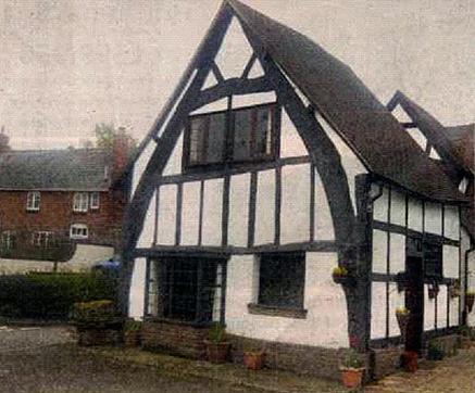
Figure 8: a cruck house
Dwellings with a cruck construction thrived in this area where we had both the timber and the stone they needed, the wealth to build them and the weather to warrant them. Over the next few hundred years, there developed a type of farmsteads unique to this area that have attracted considerable scholarly interest for their immense solidity and unpretentious character. Richard Suggett in his 2005 work Houses and History in the March of Wales 1400-1800 [x] suggests that the pattern of timber framed peasant houses, each different, and each central on its holding suggest a social background of small freehold upland farmsteads, each with its own yeoman farmer. Much like Craswall now, really. And Suggett expresses succinctly what we all can see: poor, steep land but big brave farmsteads. He explains it thus:
A paradoxical aspect in Herefordshire and Radnorshire is the poor hill country but a rich inheritance of numerous substantial early houses and farmsteads. It suggests the upland economy has been at some time prosperous.
Yessirreee! It was the wool. By about 1500, Craswall and surrounding Black Mountains were wealthy enough for their story to start to be told in stone, thanks to several centuries of wool. After the demise of the monasteries, the sheep stayed, with the trade links and tracks to market firmly established. The hardy peasants took up where the monks left off, selling their wool year after year, thanking their lucky stars that the fleeces just kept peelin’ off every spring.
Over the next hundred or so years, they sawed down oak trees and pegged them together, green. They dug up stone to infill the timber, and plastered it layer on layer using the lime they burned in their pits. Finally, they sought out beds of the best, flattest, hardest stone, trimmed it into tiles, drove a hole through each one, and held them in place with whittled oak pegs resting on split oak laths. Job done: a thumping sturdy house to keep out the cold blow and rainy night. Built with a vigour and confidence that still speaks out, centuries later.
Cyril Fox & Lord Raglan – the Holmes and Watson of our homes
Suggett’s book follows a tradition of interest in vernacular architecture on the Welsh border largely begun by Cyril Fox, an early director of the National Museum of Wales. He was called in during the First World War to assess a Gwent farmhouse billed for demolition to make way for a munitions factory. He saw what a venerable monument the house was, and it ignited his passion for these old houses. With his chum Lord Raglan, he drove round surveying over four hundred houses in Monmouthshire, codified the results into eras, and published three volumes of their findings.
But Fox and Raglan’s motorised jollies were nothing if not methodical. They did their spadework; they photographed, described, logged and analysed all they saw, and it culminated in the identification of three local building phases, each with distinctive features.
Phase 1: Medieval Houses, c. 1415 – 1560
Fox & Raglan dated the first phase from the settled period after Owain Glyndwr’s rebellion through Tudor times. It roughly coincides with Edward IV first hitting on the idea of diverting monastic wealth into the secular community. Small yeoman farmers were in the money for the first time. They built the earliest surviving examples of the ‘peasant hall house’: rectangular, cruck-framed, half-timbered, single-storeyed, unglazed.
My disclaimer: this is part research, part speculation
Take a look at the Goose Cotts. I imagine it came first at Dukes Farm, probably around 1500. The crucks are embedded low in the walls, at shoulder height, and they are blackened with soot. So were the original oak tile pegs, which we replaced when we renewed the roof in 1997. In its early days, smoke from a fire on the bedrock floor would have simply filtered up through the tiles. The chimney and fireplace are later additions.
So ... the Goose Cotts was a single space built by a spring on bedrock with its back to the weather. It had unglazed mullioned windows to let a little light in, and a fire in the centre of the room to warm it. It doesn’t come much simpler than that, but the strong cruck construction made it king to anything that had existed before.
But, my dear, the damp!
The wool merchant must have paid well to justify our farmer being able to build such a strong little house. But Farmer Dukes’ first house also had its back to the sun, with a spring running a tad close to the door. Maybe his duchess complained of the damp? No matter: times were good. Farmer Dukes was soon in a position to build another, bigger house at right angles to the first. This second house had a gable end that shouldered the weather while the front windows faced the morning sun. This time, the walls were higher, with four pair of oak crucks erected in a row, curving down into the walls of the house. The interior space was completely undivided, still a simple peasant hall house.
This early design of house usually had two external doors facing each other on the long sides. You can see the massive door posts and frame of one of them in the boot room, now infilled with lath and plaster surrounding a smaller door. The lintel of its opposing door is also intact, under the office window at the front of the house.
Sub-Medieval Houses, c. 1550 – 1610
“There’s posh you are ”
Time went on, and houses became bigger. Crucks gave way to straight A-frame beams topping stone walls, but still jointed and pegged together for flexibility and strength. And still with an undivided interior. Imagine it: a single space inside a busy dwelling. Pretty cold and inconvenient, so it did not last long. Fox and Raglan date the start of a second phase of building design at about 1550 when there were two marvellous innovations: a chimney, and an upstairs. An internal chimney stack kept the house warm without filling it with smoke, and an upper storey? It was warmer, safer, posher, and doubled your living space!
This second phase of building was the most fruitful, resulting in the largest number of local farmhouses. These sub-medieval houses were more varied in their ground plans, and more idiosyncratic in their detail than the peasant hall house. They are still cruck framed, with stone floors, roofs, and immense rubble-filled walls, but they often have L- or T-shaped floor plans, and jettied porches. They invariably have an oak and stone spiral staircase winding up beside the chimney breast inside the depth of a wall. That’s how thick the walls are.
Once the joy of separate storeys was discovered, the dwelling was sometimes divided up further with oak panels of a particular local design. Called ‘plank and muntin’ panelling, it comprises vertical oak boards placed cheek by jowl, thick and thin, set into an outer frame. Ken has recreated a small section in the Granary dividing kitchen from stairs, but some of our neighbours in the valley have whole magnificent sixteenth century walls of it.
Farmer Dukes built the Granary and the Swallow Barn during this second phase. The continuous stonework of these adjoining buildings shows they were built at the same time; a dwelling and its complementary work space. The Granary was built with an upper storey, internal divisions and a fireplace typical of this second phase, but the original windows in the front suggest it was built before glazing was commonplace, so probably early on, around 1550 – 1575. It has a refined domestic character: a stylish ogee lintel to the external doorway, decorative chamfer ends on its ground floor beams, and elegant cut stone around the fireplace.
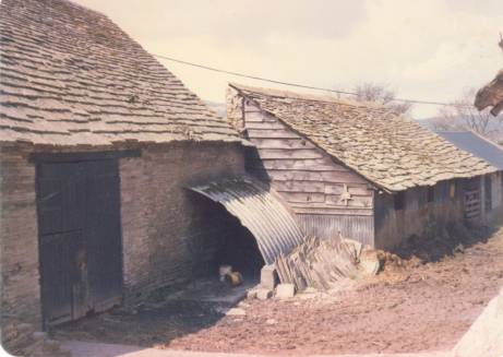
Figure 9: the Swallow Barn & long shed in 1987
Farmer Dukes was on a roll
The wool bonanza continued, and the building boom it stimulated. Although they have none of the distinctive features of sixteenth century building, the big barn on the far side of the yard and a tall-but-tiny buttressed lean-to on the south side are clearly quite old too. Their appeal is diminished because they have both lost their stone-tiled roofs: the big barn to corrugated zinc, and the tall-but-small shed to a heavy fall of snow in the 1990s. Its astonishingly tall buttressed back wall is all that is left, used for parking now.
Those buttresses make you realise that the sloping site at Dukes Farm had an upside and a downside! The bedrock that was cut out to level the site on the top side of the slope would have conveniently supplied much of the building stone in the walls, as if the place was built in its own quarry. But the land falling steeply away compelled them to buttress the walls below. What a job it must have been. The locality must have been heavily populated in the sixteenth and seventeenth centuries to supply all the stonemasons and muscle-bound labourers who quarried, carried and lifted that stone all their days.
No plannin’ office, them days …
All this time, Farmer Dukes must have been doing very nicely, thank you. He was improving his living accommodation too. In line with the times, he built a six-foot thick internal wall in the farmhouse, containing both a chimney breast and a staircase to an upper storey. Once a staircase and first floor were installed, the upper storey of the farmhouse must have been as dark inside as Jonah’s whale. No matter! Farmer Dukes merrily sawed through the central purling to put three dormer windows on the sunny side. He enlarged the ground floor windows, so only two original windows remain now, on the north gable end away from the mountain. Imagine trying to convince the planners of any of those changes now.
The Goose Cotts and the farmhouse were originally separate buildings. The bedrock lies near the surface here, so the alley between them would have been muddy, uneven and slippery. No wonder Farmer Dukes soon put a roof overhead and joined the two together with the oh-so-useful boot room.
The economy driving change
At some time, the Granary was demoted to a working building with external steps for access, grain weights written on the timbers, salting slabs round the walls, and a drain in the stone floor. It stored grain during both World Wars, Ken’s mother separated milk and made butter for sale in there, and all our farming lives it stored our firewood and veterinary paraphernalia. The Goose Cotts also became a working building. It acquired a poultry loft, and five goose cotts where breeding pairs of geese were kept in the days when poultry keeping was a viable cottage industry.
In the most recent chapter, the modern range of farm buildings was stimulated by agricultural grant aid in the 1970s and 80s. Meanwhile, the upkeep of the old stone buildings was a constant worry, with repair of their roofs a regular summer job. Eventually, we found the resources to renew the roofs one by one in the 1980s and 90s. We never dreamed as we set to with scaffolding and ladders that they would one day be dwellings again.
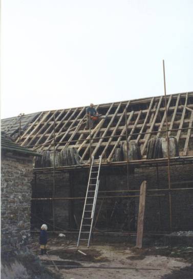
Figure 10: reroofing the Swallow Barn in 1993 (Arthur watching)
The sad demise of Craswall Priory
While the valley was building, the single reminder of its monastic past was gradually pilfered for stone. The doorway, the fancy east window, the piscina in the porch, and the corbelled mouldings round the vestry fireplace were all carried down the valley to embellish the church. Who knows how much from the Abbey is in the walls of local farmhouses? A lead cask containing a left forearm and hand, relics of a forgotten saint, were found during excavations in 1904. All that remains for pilgrims and visitors are the overgrown fishponds, the stone altar and some stone walls.
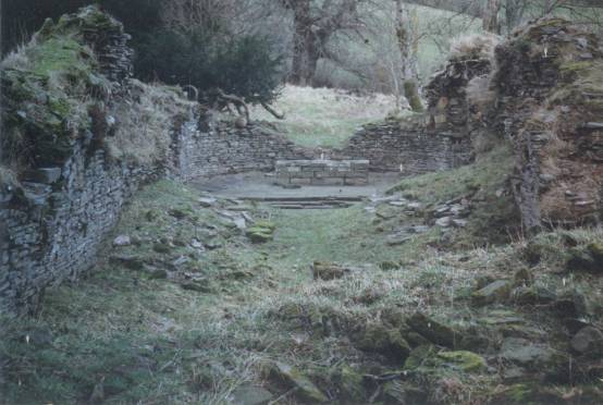
Figure 11: Craswall Priory altar
The Eclipse of England’s Wool
Over the centuries, there was various politicking about
a) the value of wool diminishing the acreage under plough and thus increasing the price of food for the poor
b) trade protection to ensure wool was processed into cloth in England rather than in mainland Europe
but taken all round, trade was what made Britain great, and wool was our largest export.
Wool’s fortunes began to change when the Stuart dynasty 1602 began a new era of alliances. The wool trade with Europe started to give way to trade in exotica from the New World: tea, coffee, tobacco, silver, spices, those intriguing brown slaves, and wool’s great rival, cotton. Wool began to look oh-so-last-week when it had to compete with products from around the world. But from the time King Offa supplied woollen cloaks in 796 to Charles, King of the Franks until the moment in 1585 when Sir Walter Raleigh held out a ball of cotton to Queen Elizabeth I, the monastic network and pan-European alliances and wars cultivated a hungry demand for wool from these hills.
... and the sad demise of wool
The wool trade did not cease suddenly, and was valuable well into living memory. At times, the church vestry has been used to store the all-important wool crop. It was once so valuable that between the two World Wars, one successful Craswall farmer habitually saved up three or four year’s wool then bought another farm. Until after the Second World War, castrated male sheep – wethers – were kept on the mountain and shorn of their fleece for two or three seasons before becoming the main source of mutton, a meat you rarely see now.
Its value has gradually diminished. When Ken & I were first farming in the 1970s, the rule of the thumb was that the wool crop paid for the year’s sheep medication. Demand from the chilly USSR supported a good price for sheepskins, too, another trade that has disappeared now.
Even so, sheep have to be shorn. If left clothed in their fleece, they easily get cast on their backs, where they can neither graze, nor pee, nor digest. Eventually crows detect their immobility, and peck their eyes out. Unshorn, dirt in their fleece becomes fetid and infested with maggots that eat the living flesh. Both result in horrible deaths. Now we wear fleeces spun out of old Coke bottles, it sometimes costs more to shear the sheep than the wool is worth, so in the recent past, some of the wool crop has been burnt: too costly to shift.
Politics again: the Act of Union
In 1536, Henry VIII’s Act of Union absorbed that rugged buffer state, that no-man’s-land, neither England nor Wales, the Marches. He divided it between England & Wales, and ordered that English was to be the only language of Welsh courts and public office.
“His Majesty has great love and favour towards his subjects in Wales. He hath ordered that Wales shall be incorporated with his Realm of England, the people shall have and enjoy all the freedomes, liberties, rights, privileges and laws as the King’s Subjects in England.”
Suddenly, an illogical line was drawn: down the River Wye, straight through Hay, hopping up onto the mountain, running its length - almost. Then crazily veering east to join the River Monnow and away towards Monmouthshire. The work of a syphilitic madman, with Craswall trapped on the English side by a mile.
It went against the grain
In 1536, our language, our laws, our building traditions, our landscape, our place names all centred on the mountain, and drew us towards Wales. Even now, you can see the Wales in Craswall. The settlement pattern with isolated farms along tracks, hidden from the road, is Welsh. The most common surnames in the district, Watkins, Jones, Howells, Pritchard (ap-Richard), Price (ap-Rhys), Probert (ap-Robert), Powell (ap-Hywel) are Welsh. The beautiful singing voices celebrated at concerts, eisteddfods and chapel anniversaries are Welsh; the great sonorous funerals, often under the open sky because the church is overflowing, feel Welsh. We even make welshcakes, for heaven’s sake.
Finally: Fox & Raglan’s third phase - Renaissance Houses c. 1590 – 1700
Absorption of the Marches into England was mirrored by the vernacular architecture. Fox and Raglan recognised a change in building fashions by the end of the sixteenth century. They identified glazed windows, more decoration, and layout centred around the staircase. Beyond that time, they considered building design subscribed to a more homogenous and universal pattern, of no interest to their project. After about 1610, an English hegemony was taking over in building design as in everything else.
... and the Welsh language?
The Welsh language followed suit. On one of his preaching tours in 1657, the Quaker George Fox described how an inn in Talgarth in the Tewdos hundred was full of people speaking Welsh but they switched to English at his request, and “we had great discourse.” By 1848, it was reported in the same border town that English was “gaining ground fast, and understood by all but a few old people.” Welsh came to be considered backward and a barrier to progress, with English the language of polite society. By the time my Welsh mother-in-law was a child in the Taff valley, Welsh was reserved for conversations ne pas devant les enfants . Cultures are so easily extinguished.
There we’ve stayed: in the hundred of Ewyas Lacy
The line was drawn irrevocably; the township of Craswall became one of ten in the hundred of Ewyas Lacy in the county of Herefordshire. Our Welsh language only lives on in place names, and in dialect words, some of which I have appended.
Thinking about the Act of Union deflates me. All that hardship, all that graft, the wars, the cruel subjugation, the castles, the wool, the building of our glorious houses like a hymn to the land itself. And it turned out we were just destined to be a forgotten bit of England.
But, as things have turned out, it was not all bad ... The Golden Age of Agriculture was yet to come...
The Golden Age of Agriculture
Herefordshire’s traditional fame lies with three distinctive crops, cattle, cider apples and hops.
These three crops were all instrumental in the farming boom. The 1840s and 1850s are acknowledged as England’s Golden Age of Agriculture, but those decades were just the pinnacle. Producing food had been – excuse the pun –a growing thing for centuries. With its well-established farmsteads and new links to England, Craswall was part of that glory, helping to supply the population of the great Industrial Revolution with food and raw materials.
Hops are latecomers to farming’s table - they were introduced into England from Germany in the seventeenth century. So demanding is the crop that only the deep rich soils of Kent and those of east Herefordshire are suitable, and there is no tradition of hops in the uplands.
In summer, you’ll see cattle of all kinds in the fields. Their colour is a big clue to breeding, and most farmers stick to one type or another. Old-fashioned brindled and roan cattle are always a pretty sight with their lofty rare breed ancestry. Nowadays, you will see plenty of the pale meaty giants of Europe – Charolais, Blondes, Simmental – with their fluffy champagne coats. There are always some plump black or ginger Limousins, famous for being easily spooked and best avoided. There are very few patchy black and white milk cows because milking has become so unprofitable that it has almost died out locally as a way of making a living.
Back in a big way
But the largest contingent still have the characteristic white face, thick curly coat and short legs of the Hereford and its crossbreds. Yes, Hereford cattle are popular again. In these straitened times for farmers it is easy to see why. The bulls are mild and manageable, the brood cows calve down easily, and their offspring are hardy and docile: easy to rear and easy (too easy, some would say) to fatten. They just seem to suit it here. Some strains are even naturally polled, so there’s no need to dehorn them.
And they breed true. The characteristics of Hereford cattle are famously reliable: their white faces, their sane natures, their symmetry, health and vigour pass consistently on when crossed with other breeds. They are perennially popular the world over for imbuing hybrid cattle in every clime with their good qualities.
To look at why they breed so reliably true to type, we can go back to the Domesday Book in 1085. It records the Benedictine Priory of Leominster carrying eighteen hundred plough oxen on its eight thousand acres. A similar number of brood cows would have been needed to maintain such a huge stock of draught animals. These triple purpose cattle, bred for draught, meat and milk, were the progenitors of today’s Hereford cattle.
The Priors of Leominster and Abbots of neighbouring Wigmore farmed cattle this way for over four hundred years before secular power wrested their wealth from them at the Dissolution in the 1530s. Their vast herds of cattle passed into secular hands, but stayed on the land, with the breeding lines undiluted. This is the crucial point, because even now seven of the most famous dynasties of Hereford cattle, herds dating back hundreds of years, still exist today on land once belonging to those monastic seats, the very same cattle families on the very same land. It means they have been bred and used on Herefordshire’s heavy clays for about a thousand years. A thousand years of curly white faces and stocky good nature – no wonder they breed true.
The earliest exhibit in Hereford’s excellent Cider Museum ’s [xi] is an apple-pressing trough. It is simply dug out of a tree and came from a farm in the neighbouring Olchon valley. Every farm, even in the uplands, made cider or perry, and every farm worker was partially paid in cider – up to a gallon a day, according to some records. It is probably how they endured such hard work come rain or shine. Cider mills are not unusual in barns in the district. Here at Dukes Farm we still have two old perry trees above the silage barn in the old orchard, and the barrels on the yard would once have held cider.
Britain’s first book on apple varieties – The Pomona - was published two hundred years ago by a Herefordian. In the current food heritage revival, the county has a wealth of apple historians, many celebrated local varieties, and a wonderful annual Big Apple Festival in the autumn: www.bigapple.org.uk
Cider currently has something of an identity crisis, not knowing whether it wants to supplant lager as the drink of choice for louts, or whether it wants to speak a sophisticated language all its own, like wine. In fact, it is doing both, which is good for Herefordshire because cider is fashionable again. Apple orchards are gobbling up Herefordshire’s acres despite the government’s new cider tax, and you will find micro-brands of very good local cider in every village shop. Try Gwatkin’s, Broome Farm or Dunkerton’s. Westons [xii] , Herefordshire’s second largest cider maker, has a good visitor centre at Much Marcle where you can ride on a drey, walk in the orchards and taste their many excellent brews. It and its café come highly recommended by several of our visitors. Cider was traditionally blended, with apple varieties characterised as sweets, sours, and the most important, the bitter-sweets. Currently there’s a trend towards single variety cider that makes for an interesting debate. Try some …
It is quaint but truly touching that the giant Bulmer, offshoot of the even more gigantic Scottish & Newcastle, still accepts tiny consignments from the smallest orchard. You can load a few bags of fruit in your boot, and reverse your cranky old farmer’s car up to their loading bay alongside the ten tonne trailers, and get a delivery slip with all the rest.
Meanwhile, what was going on in Wales? Droving!
Nowadays the shortfall in English beef is made up from South America, but beef bred in Wales has been served up on English plates for centuries. Welsh cattle were shod and driven on foot in their thousands to be fattened on English pastures. They travelled on established routes north and south of the Black Mountains.
Still waters run deep ...
It was as if the waters of trade flowed round each end of the mountain. Commerce eddied round north and south, gathering a still pool in the lee of the mountain, in our freshly isolated bit of England. We were too rugged for the rich agriculture of Herefordshire, but we also missed the invigorating passage of the Welsh drovers with their scallywag tales and ready cash. No wonder Craswall had a reputation for being a bit cut off. But it also gave us a reputation for being self-reliant and resourceful. Wool was still a cash crop, but in the mixed and localised farming of the past, we grew our own grain, brewed our own cider and made our own cheese and butter.
And famous for ...
This area has become increasingly known for its breeding stock. Because the land is poorer and the seasons shorter, we produce animals that are ideal for breeding. Not too fat to be fertile, nor too big and rangy to last, upland farms produce animals with great longevity and vitality: thrifty, hard-footed, tight-bodied, with good locomotion. There is a strong tradition of pedigree and commercial stockbreeders and showmen hereabouts.
... and hedgelaying ‘Border style’
The other local speciality is what you might call our boundary skills: stone wallers, and dynasties of hedgelayers. We have been confining livestock since Neolithic times, when man first learned to weave a stock-proof barrier to control his domesticated animals, so it’s no surprise that our local farmers excel in hedgelaying competitions, with the tradition thriving in Craswall Young Farmers Club, which usually wins all the county’s prizes.
And of course, there’s the sheep
As we’ve heard, brown Soay-type sheep crossed on the land bridge with the Neolithic herders they sustained for over three thousand years. The Romans added their own white sheep to the palette. The Danish Vikings brought their black-faced sheep with them, which became the Scottish Blackface of northern Britain.
But the real story of modern commercial sheep began with Spanish long-wool sheep, which were brought here in the wake of Eleanor of Castile, the wife of Edward I. These long-stapled wool breeds were prized during the Agrarian Revolution when animal and crop breeding accelerated to vastly increase the amount of wool we produced for manufacture and the amount of food we grew for those who lived and worked in the growing towns. They were central to the development of two sheep breeds: the Blue Faced Leicester, and the Border Leicester.
In their pure form, these two valuable breeds are what we call ‘nesh’. Ken’s uncle told me, ‘If you’re breeding Leicesters, you need a sharp spade and a short memory!’ Whilst not hardy enough to supplant the native British breeds, they are majestic sheep which almost every commercial breeding ewe now has somewhere in her blood, creating ubiquitous hybrids called ‘mules’ and ‘half-breds’.
Because you’ll see so many sheep in the fields hereabouts, and parentage shows strongly in sheep, here’s a brief ‘I Spy’ digression. Fashions in British sheep breeds still go on. They are like generations of software technology: clunky Windows 95 giving way to Vista or Windows 7.
Suffolk : big, with sooty black faces and legs. Upside: popularly bred as ‘terminal sires’, fathering heavy, meaty lambs for slaughter. Downside: their lambs are notoriously slow and stupid, prone to death from apathy.
Welsh Mountain : small, white and suspicious. Upside: thrifty, good if you’re playing a numbers game by keeping thousands. Downside: scraggy with kempy (hairy) wool. They have a Houdini streak to outwit all; if you see sheep grazing on the roadside, they will almost certainly have Welsh blood in them.
Texel : an imported Dutch breed, also white-faced. Huge, with piggy faces and short thick necks. Upside: lots of meaty lambs. Downside: none - their owners are much envied.
Radnor : a local breed, teddy-bear ears, brown faces. Upside: motherly, milky, sane, and loveable. Downside: they die young.
Clun : another regional breed. They have narrow pointy ears set on classy black heads with tight woolly topknots. Upside: Is there one? The ovine equivalent of the minor royals - I’ve never seen the point.
The complex genetics of sheep
We could go on: there are dozens of variations on this theme, splitting into a spectrum that embraces uber-productivity at one end, and rare breeds at the other. The Lleyn is a North Wales version of the Welsh Mountain that is famous for its fecundity. The Jacob, being piebald, gains favour in the spinning and weaving fraternity. In recent years, a Dutch breed called the Zwartblee (‘Zwarbly’) has made an appearance. It’s black with a dazzling white blaze and white socks. What’s it for? Easy lambing and lots of milk, I understand. At the risk of getting into the subject too deeply, now wool is a welfare problem rather than a cash crop, there are also ‘Easycare’ hybrids which produce a short-stapled sheep that sheds its coat naturally.
The Enclosures
Back to the story of farming – where was I? About 1800, and in the rise towards its Golden Age, England’s agriculture became subject to the English government mission to measure and improve. In 1794, one John Clarke was commissioned by this Board of Agriculture to write a General View of the Agriculture of the County of Hereford, with Observations on the Means of its Improvement. Enclosure was not the big issue in Craswall that it was in much of England because the common land was relatively unproductive mountain pasture, but it does give us an interesting view of ourselves as seen by the rest of Herefordshire.
In its section on Political Economy, John Clarke explains to the Board of Agriculture that,
“The most extensive districts of waste lands , in this county, are situate at the foot of the Black Mountains, above the Golden Valley. I do appeal to such gentlemen as have often served on grand juries in this county, whether they have not had more FELONS brought before them from that than any other quarter of the county. Yet the people there are not naturally more vicious than their neighbours. IDLENESS, that fell ROOT on which VICE always finds it easy to graft her most favourite plants, and which is found to contribute so much to their future health and prosperity, alone form the characteristic difference.
A cottage, with a few acres of inclosed land, gives the occupier a right to turn stock to these common hills. The profit of that stock is expected to supersede the necessity of labour, in cultivating the few acres which he possesses: should these hopes, however, not be realised, any method of providing for the demands of the day is preferred to the drudgery of labour.”
He goes on to discuss the value of enclosure of common land, claiming “the amount of their produce of food, for society, at double what they let for, and produce, in their open common field state.” He even claims that the birth rate in parishes that have been enclosed is twenty per cent higher than in more ‘backward’ parishes where common land remains. Hmmm... the purposes to which statistics are put. And this is his reason:
“One cause of the increase of inhabitants, by inclosure, is evident; not only to reason, but to experience, in every quarter of the island. The operations of fencing, draining, roadmaking, building, and other improvements, draw together a number of hands, from the surrounding country; some of whom settle and rear children, in the parish inclosed; where they become permanent residents. For an enclosed parish or township requires, in most instances (not all) much more manual labour than it did while it lay open.”
Lest we should think the argument unbalanced, in the chapter entitled POOR RATES, he brings his benevolent logic to bear:
“To deprive the poor of that benefit, which, in their present state, they derive from the waste land, must, no doubt, at first view sound harsh. But it ought to be remembered, that in this wealthy county, where there is so much work to be done, and so few hands, comparatively, to perform it, there are few poor that do not deserve to be so. Those persons who are disqualified to provide for the calls of human nature, by the feebleness of infancy, the crushing hand of disease, or the infirmities of old age, cannot be said to be poor, because ALL the landed property situate within their respective parishes, is always liable to be charged with their maintenance, whatever changes may take place in respect to its owners, or occupiers.”
And in a final triumphant flourish at the end of the chapter, he proudly maintains,
“The rights of the poor remain unalienable, while our present, just, human and wise laws have an existence.”
So in our own very English version of the Doctrine of Manifest Destiny, the wholesale enclosure of common land was enacted; by Parliament, by landowners stroking their bulging bellies, by land agents fingering their maps. It was enacted by men striding across the turf itself with yardsticks. It was ultimately enacted by millions of hawthorn plants grown for the purpose, and finally by the poor commoner wot dug the ‘oles and put them in, paid pence per day.
All for his own benefit, it seemed, if property in his parish was to be charged to his maintenance, whoever owned or occupied it!
Hawthorn is still known as ‘quick’ or ‘quickset’ on account of the useful speed with which it propagates and grows. If you walk round the farm, you’ll see the top fields laid out in rectangles, with vestiges of those original quick hedges remaining today. On the 1840 map, this was all open land, but by 1870 the eastern fields were divided up as a result of one of the Enclosure Acts. The prosaic field names Seven-Acre and Ten-Acre reflect that era of measuring.

The White Noise of Recorded Time
Craswall’s register of births, marriages and deaths began in 1703 as part of Clodock’s records because the township of Craswall was ecclesiastically a chapelry in the parish of Clodock. We were still a chapelry until a full licence to hold weddings was granted in the 1960s.
The story of Craswall starts to move from the general to the particular. History becomes a process of sifting through the detail of parish records and the white noise of family anecdote.
Civic life and communal responsibility as we know it were beginning. Several poor charities were instituted during the eighteenth century. Each of our children owns a book of prayers provided by the Elizabeth Thomas Charity. In 1759, she gave Charity Farm in Llanveynoe to provide funds for educational purposes. The farm has long since passed into private hands, but the charity remains with its assets yielding occasional small dividends which are spent by its trustees to benefit local children.
1800 AD - What was Craswall like then?
We have a clue of how densely populated this landscape was in the first census in 1801. There were 391 residents living in Craswall, more than double today’s population, and they were living in larger households. The church had a fives court and a cock pit – Craswall must have been sociable community.
A hundred and nine dwellings, twenty unoccupied
Although it had a hundred and nine dwellings, twenty properties were uninhabited. Perhaps they were the kind of temporary hovels that predated our stone houses, gradually replaced during England’s great industrial growth. Possibly, because at the same time, there was another wave of building in the valley. The cottagers, labourers, tradesmen, and craftsmen who flourished by servicing the food producing economy of farming’s Golden Age were also building themselves new dwellings. These subscribed to the two-up, two-down design that found favour throughout the land. They were usually built on the road side or along green lanes. They usually had outbuildings too, and they always had enough land for their owners’ domestic economy. Many of them still survive in the parish.
Hovels by the wayside ...
Prior to the census, it is not possible to know how many dwellings existed on the land. The dowser who helped us find the source of our spring, working only from a map, detected old habitation in Cae David. Sure enough, the land lies tumpy and uneven there, so maybe Cae David was originally occupied by David? There were certainly derelict buildings in the tiny plot that we planted up with trees for firewood in 1983. It is marked 5399 on the map, but we call it Michael’s Plantation.
Much woodland would have been coppiced by 1800. Coppice, particularly hazel coppice, was used to fuel the lime kilns. At each end of our Brake there are sizeable areas of hazel coppice that would have been cropped on rotation to fuel the lime kilns that stood nearby. In a wider context, before the use of coal, coppice was also in great demand for conversion into charcoal to fuel iron foundries. It takes four tonnes of wood to produce one tonne of charcoal, and seventy tonnes of charcoal to smelt one tonne of iron.
Infant mortality and poverty
Through the early decades of the nineteenth century, Dukes Farm was home to successive farm labourers and their large families. Life was tough, particularly for the elderly, the women, and children. In Herefordshire in 1831, one in four children died before the age of five, and three parish paupers are named in Craswall’s census of the same year, all over seventy, with no address recorded.
The Chapel tradition
Country life in the nineteenth century was harsh and hierarchical. The egalitarian and inclusive ethos of non-Conformism offered a helping hand, and its congregations grew. When Wesley died in 1791, he wanted his followers to remain a vital force in the Church of England. But the Church had other ideas. It rejected them, and those practising Wesley’s strain of evangelical Christianity became known as Primitive Methodists – ‘methodists’ because of the way he had organised his followers into classes who met weekly, with a firm structure of elders, and a tradition of non-ordained preachers. It was a structure which allowed members to support each other, and in which the working classes and women found a status otherwise denied them. Abandoning the established church for a chapel community was often an act of defiance by parishioners.
Like the rest of Wales, many chapels sprang up in the lee of the Black Mountains. There were three in Craswall alone, two of which were places of worship into the 1960s, and Ken performed at their chapel anniversaries as a child. Several Methodist and Baptist persuasions flourished and continue to flourish locally in other local parishes. Their traditions of temperance, singing, and annual outings must have softened the lives of women and children immeasurably.
The Tarnish of that Golden Age
The repeal of the Corn Laws didn’t begin to bite at first, but by 1881, the government saw increasing misery in the countryside, and commissioned a Royal Commission into agriculture. This decline is reflected in Craswall’s records. By 1891, the population had declined by 35% to 272, and similarly, a further third of the dwellings had fallen into disuse. A third of the houses lost in forty years puts our current perception of rural depopulation into perspective.
The commerce of the Scots
In the 1860s, Scotsmen came to Craswall. Was that to do with the Corn Laws, the upheaval caused by the Highland clearances, or merely that the Michaelchurch Estate employed a Scottish land agent? Probably all three are related.
In the 1861 census, a single man, David Strachan (29) from Forfarshire was living at Dukes Farm with two farm workers. By 1871, he had been joined by a wife, Ann (41). Although they were childless, Ann’s sister Mary Buchan had died, and the Dukes became home to her four orphaned children. We know this because the grandson of one of them used to visit us occasionally as he compiled his own family history.
Gleaned from parish records: one sad tale
The Strachans brought with them from Forfarshire a young farm worker and his new bride. In the 1871 census, this young man is named as a single man again. Why? Because his teenage wife is named in the funeral register of the previous month, and her infant two weeks later. How she must have suffered in childbirth. I imagine the silent and wretched men who unhinged a door to carry her body out to a cart for burial. And poor Ann Strachan - running a household haunted by the mewling cries of that baby, struggling to keep it alive with cow’s milk, then wrapping its tiny corpse and carrying it away for an unmarked burial.
... and gleaned from maps
Our original name Cressewelle had become Crasswall by the time maps were created, and this double ‘s’ spelling persisted until Ken’s schooldays. Since its days as a township in Ewyas Lacy, Craswall has incorporated the separate township of Fforest Henne. Also showing on early maps is a different access to Dukes Farm. Until the 20th century, our drive ran steeply down between the two fields below the farm, fording the river to join the road on the other side of the valley. The vestiges of the oak avenue that bordered it still exist down the east side of the Big Meadow. Aren’t we thankful it fell out of use and we have a level drive.
Dukes Farm was known as Upper Llandraw until the 1835 map when it had two names, ‘Upper Llandraw or Dukes Farm’. We have not discovered why its name changed. Years ago, someone told me a Mr Duke was buried locally, and suggested he lived here, but we have failed to trace the headstone so far. There are other Dukes Farms in Herefordshire, suggesting they may have been demesne farms serving a local estate. Maybe the truth will come to light one day...
The next chapter, and Craswall’s gain: the Ganes
In the 1790s, a Mr Gane and his sons came from Somerset to mend the church bells at Clodock. After the bells were swinging and ringing, some of the Ganes stayed on. In 1851, Thomas Gane (31) his wife Mary (30) were living at the Bulls Head with their three sons aged 5,3 and 1. Another Gane family lived at Court of Craswall with their widowed mother. By 1891, another Thomes Gane was living at the Bulls Head with his wife, a local girl Hannah (née Pritchard) and nine children. Eventually, this couple were to have thirteen surviving children, and a pair of twins who died. All wed, and most bred. Most of them stayed in Craswall, so many of the longstanding locals, including Ken, are direct descendants.
“Education for All”
Craswall school was built in 1876, but even before that there was a school in the church vestry that local children attended for a penny a week: a ‘Penny School’. In the winter they took a potato every day to cook in the school stove for their dinner.
Dissing the Scots
By the end of the nineteenth century, the Strachans had moved from Dukes Farm, we know not whither. In my father-in-law’s day, the local wisdom was not to take a tenancy after a Scotman; they were arable men who grew potatoes, which exhausted the land. In the first half of the twentieth century, Dukes Farm became home to various farmers and farm workers.
The Watkins dynasty
By contrast, there have been the same family of Watkins at Old Mill since before 1841. In 1891 James Watkins (11) lived there, the second of seven children. Meanwhile, Annie Gane lived at the Bulls Head with her parents Thomas and Hannah, the third of nine children.
Can you see where this is leading? By the 1901 census, James Watkins (21) from Old Mill was living alone at the Coed, a now-derelict farm in the trees directly across the valley. Annie Gane, one of the thirteen reared at the Bulls Head, must have joined him soon after because in 1905 their firstborn William James Thomas was born: Ken’s father.
When we walk past the Coed to the mountain, I am struck by how isolated it must have been for Ken’s granny, Annie, coping with a new baby, and no hot water or little runabout car, until I remember those things would have made no sense to her. She lived as everyone lived, with all her family within walking distance.
We are now entering the age of handed-down and living memory, which places different demands on the story. Annie is remembered as a tough cookie, hell-bent on domestic cleanliness, and disapproving of pleasure. No wonder: she was sent into service when she was only nine to milk five cows, but had to return ill after three weeks. Sick for home, I shouldn’t wonder, poor little mite.
Of that generation, I only knew the youngest sister, Aunty Dolly, who had no children. She was a welcoming old lady who took a bird-like interest in this girl ‘from off’ who married into the family. She and her husband Uncle Harry used to ply us with their strong parsley wine when we visited, and she left us a bedroom suite in her will.
The wider economy of the Black Mountain
At the end of the Second World War, the entire Black Mountains were owned by just three landowners: the Michaelchurch Estate, the Evans-Bevan family, and the Marquis of Abergavenny. Little has changed: they still are, and the mountain is still divided up by the old marker stones and natural boundaries. Ownership amounts to little of benefit except grouse shooting and mineral rights, and there are none of either. Grazing rights accrue to the farms with fields adjoining the mountain.
Being on the east side of the valley, Dukes Farm has no mountain grazing rights. For the many farmers who do, there is an active Graziers Association. In my father-in-law’s farming days, the farmers walked up the mountain each morning to drive their hefted sheep up their customary range to make best use of all the grass. Grazing rights are exercised less nowadays, and are complicated by various grazing and/or non-grazing agreements with the government via Natural England. Their policies currently revolve around stemming bracken encroachment, which seems to be a problem everywhere in the temperate world.
Farms up for rent
Meanwhile, ownership of Craswall’s farmland changed radically during the twentieth century. Kelly’s directory of 1922 tells us that most of the land in Craswall was owned by two landowners. Most farms were tenanted on three to five year terms, so families moved often. Ken’s father, Bill, lived in seven properties in his life, yet never moved out of the parish.
As a young man, he rented the Bulls Head with his sister Beatie. At that time, it was a farm with an ale house attached. The landlord (or probably wifey) would go down the stone cellar steps and bring up a jug of beer for farmers or shepherds who called by while tending the mountain. There were few tourists then. Craswall was a largely self-sufficient community with paths and tracks as familiarly used as the roads, folk travelling on foot and by pony.
In 1942, Bill married the girl next door. Her family had moved from Cwm Taff, which was dammed to provide water for the growing cities of South Wales. They lived at the Bulls Head for the first five years of their marriage, and both their sons were born there.
The Petrochemical Age
While she lived at the Bulls Head, my mother-in-law remembers a neighbour riding by on his pony to attend his daughter-in-law’s funeral. But change was in the air, and it smelled like diesel. One of Ken’s earliest memories is of the valley’s menfolk arriving at the farm to help bury a horse. By then, the farm had a tractor, and she was their last working horse, called Blackbird. Apparently, the first farmers to buy Land Rovers drove them at a similar speed to their horses.
A small coincidence
Exactly one hundred years after Wordsworth and Coleridge walked up the Wye valley into the Forest of Dean, talking the while of their Romantic ideas, working men and women took to the hills in a daring act of civil disobedience. The Mass Trespass of Kinder Scout in the Peak District in 1932 was another crucial step in changing ideas and norms about the countryside. The green registered footpaths that now guide us over private land were conceived on that day, although it took another two decades to implement them. It was another result of the diesel age. The countryside looked more romantic to a population gathered into towns. Walking had become pleasure rather than necessity.
Things look up for the Dukes
After the Second World War, estates began to struggle, and many were broken up to realise some capital. It enabled Ken’s parents to buy Dukes Farm from the Michaelchurch Estate in 1953. ‘The Dukes’ as it is known locally had been empty for six years prior to that. It was in poor shape. The floorboards in the house and Granary were riddled with rat runs, and the farm reputation blighted by its last unpopular tenant, John Edward Jenkins. The farmstead was derelict and lonely, much like this photo taken in 1927 during a Royal Commission on vernacular buildings that resulted in the Dukes being listed. Grade II it may have been, but it was certainly in need of some Tender Loving Care.
Times were hard for farming
In the years between the World Wars and immediately after, paying the rent was the first priority for farmers. The farmer’s wife was responsible for providing the income for housekeeping. Everyone worked. Domestic poultry, dairying, and thrift kept the family. All the farmers’ wives around, both Ken’s grandmothers among them, took eggs, dressed poultry, butter, maybe cheese or vegetables to market every week. By that time there was a weekly bus to Abergavenny every Tuesday. Our great chronicler, Raymond Williams describes in his first novel Border Country how the local country communities were affected by miners’ strikes, unemployment and disease.
Ken’s mum was an excellent poultry woman who bred and reared turkeys, geese and hens. She also made butter, and Ken’s Saturday job was to run round the valley delivering it. When Ken’s parents arrived here, there was grain in the Granary left over from the War - we still vac up oat husks that filter down through the beams. The beam and walls have corn weights pencilled on, along with that little drawing of a dancing girl, presumably the fantasy of a young labourer. The dairy windows looking onto the mountain were shuttered, partly with perforated zinc, and when Ken was a boy, his mum would pop him through into the field below when he was late to run for school.
‘A monotony of losses’
Looking back to 1801 when there were nearly four hundred folk living in Craswall, the twenty unoccupied dwellings probably made it seem even then as if a rot of dwindling population had set in. So many properties have been lost to us: Peckadilly, Kill Horse, the Coed, Old House, Trelan, Peggys, the Bacho, Paradise, the Palace, Llanoley: many of them occupied in living memory. Roofs and walls beyond repair for want of sufficient capital, or a reliable water source, or realistic access. By the time Ken’s parents bought the Dukes, the population had dwindled to 185 in just forty five dwellings although the parish still had two pubs, a church, three chapels, a shop, a post office and a school. No wonder all have now gone except one pub, the village hall and the church. We think rural depopulation is a modern phenomenon, but as we have seen, farms and dwellings have been falling derelict for two centuries, and it could have so easily been the fate of the Dukes.
Our Fifteen Minutes of Fame
In this long human story covering tens of thousands of years, it seems bad manners to take more than the millisecond that is our due. Yet it is a story people seem to like: where we fit in.
Ken
Ken had one of those free-range country childhoods, with a bigger brother to do everything with, plus cousins at neighbouring farms. He seems to know every tree and dingle in the valley intimately, and recognise every bird’s song. He always came home to his mother’s baking. His was the first year to take ‘O levels’ at the local secondary school, then he spent a year or so at a neighbouring farm before coming home to farm at the Dukes.
Me
I was a dairy farmer’s daughter from south Warwickshire, precocious only in that I took a gap year, unheard of in those days. I came to milk a herd of cows in Rowlestone. Well, it was my undoing inasmuch as I never went to university. I met Ken at a Young Farmers’ dance: a farmer with a huge laugh and the singing voice of an angel who carved intricate lovespoons in his spare time. What girl could resist?

Figure 12: Ken & Ruth Watkins in 1986
The rest is history
We married the week of the Queen’s Silver Jubilee in 1977, and I celebrated my arrival in the valley at the Craswall Jubilee Sports. The following year, parishioners had a similar event with a sheep sale that raised enough money to buy the old school for a village hall – quite a testament to community spirit. Ken’s parents retired to the old schoolhouse where Ken’s mother still lives, and we have been here ever since. It feels as if this farm and the Cats Back beyond occupy the inside of me as well as the outside.
We farmed together for twenty five years before Foot & Mouth took our living in less than an hour. Until that moment, we farmed, though, inevitably, farming changed over those twenty five years. To begin with, we continued to fatten, dress and sell turkeys in Abergavenny market, but it was the twilight of the domestic poultry economy except for the few hens we had until recently. We erected modern buildings to house the livestock and store fodder. We made silage rather than hay. We kept pedigree cattle, not crossbreds. Ken’s joinery enterprise grew while the sheep flock diminished. As the family grew, the vegetable garden gave way to dens, footballs and a trampoline. Phew! It is a hay cart of memories and I wonder how best to stack them. Barn by barn, I think, the oldest first.
The Goose Cotts was the Cart Shed. It was open-fronted with the windows unglazed. A broken cast iron grate in the fireplace spoke of smithying at some time in the past. The right-hand side was lined with goose cotts – little elm huts where Ken’s mother kept her breeding pairs of geese, hence the current name. The mezzanine was a poultry loft; the walls yielded scores of chicken carcases when we cleared it out. There was a monster vice bolted to the wood inside the door, and grease on the window sills, still grooved with thousands of sharpening strokes. We housed the tractor - a blue Fordson Dexta - in the left-hand side, and tools of the trade in the right: a saw bench, corn mill, swede chopper, sheep marker, wire strainers, tools of every kind. Ken did his welding here, the water tank handy for cooling hot metal. All the while, the sooty roof and beams shed black cobwebs and dust on to everything below.
The Granary had been built as a dwelling. But was it ever used thus because the fireplace looks fresh and unused four hundred years later? When Ken’s parents moved here, there was grain in the Granary, and the dairies on the ground floor with their salting slabs round the walls housed a separator, butter churns and a cheese press. By the time we married the days of dairying were gone. We provided our own milk by stealing a pint or so each day from the milkiest cow, and even made a few cheeses from the milk of early-weaned ewes, but we were playing at it.
The Swallow Barn was the Beast-house. The threshing door facing the mountain was walled up, as were both doorways in the right gable end, one of which is now a window. Like both the other barns it was open to the stone tiles, which shed motes of sunlight below, and gritty dust with every breeze. I remember how the light of a single electric light bulb shone patterns through the beams on to the underside of the stone. Each winter, it housed five cows and their calves. Daisy, Myrtle, Fenny, Violet and Freda, all brown or black with white Hereford faces, stood to the right of the door, each in her own stall. A cow reared two calves in her lactation. While she was freshly calved, another calf was bought for her at market, the surplus from a dairy herd. Cow and calves were kept separated, and the herd attended twice daily while both calves suckled. The big barn across the yard housed a dozen or so more cows and calves, with their hay stored on the tollert above.
The calves were penned on the left inside the Swallow Barn. The door to their pen was worn furry where generations of calves had licked at the wood. The entire floor was drained by pitching – cobblestones set on their edge, aligned to drain the cows’ waste to a gutter along the centre. Each winter morning, once the calves had suckled, we would turn the cows out to their field, clean out their standings with a wheelbarrow and fork, and spread fresh straw for the next night. The muck was then added to the mixen in the yard, which would be ten foot high by spring.
The Long Shed is now the patch of car parking concrete with a high wall behind. It was a dark narrow shed with a stone manger, corrugated tin walls and a roof tiled with stone. It housed weaned calves in the winter, and in the summer its stone roof made it cool for sorting, dagging, foot-rotting and drenching sheep. Then one morning in the early 1990s we looked out and a snowfall had caved in the roof while we slept: instant demolition.
The Games Room was called Ivor’s Shed, after the builder who helped Ken’s father erect it. Like the long shed, it did various jobs: housed fodder, young stock or calving cows.
The farmland is the engine of the enterprise. We always grew one field of swedes that the sheep strip-grazed for their winter fodder, and made a third of the fields – the most level and accessible acres - into hay. That’s about four thousand small bales. Once these were stacked in the field, they could be was carted up to the buildings and stacked again, right up into the apex of the buildings on the hottest days of the year. The remaining eighty acres of grassland grazed cattle in summer and sheep all year.
Since the livestock was culled, the land has been let annually to a couple of neighbours who run their own animals. The fields still need fencing on a twenty year cycle, a job we’re enhancing by planting hedges protected by double fences. We have recently undertaken a project with Natural England to restore the twelve acre ‘Big Meadow’ to its traditional herbage. As well as the usual buttercups, daisies and clovers, it now grows several species of carex, yarrow, knapweed, ox-eye daisies, alchemilla, various vetches and compositae, and the semi-saprophytic yellow rattle.

Figure 13: Ken with his Limousin herd
The land that makes us happiest is the seven acres of woodland . Some we have planted with firewood and livestock shelter in mind. Some of it is ancient high forest, untouched since Neolithic times and before. This grows indicator species such as meadow saxifrage, sanicle and helleborine.
The farming year starts in the autumn. Once the hay is gathered in, the straw stored, the ewes are settled into small groups each with a tup for mating. Then the cows start calving, the clocks go back, and the nights are suddenly very long. Farmers know they have to dig deep through another dark winter when every day for five months is taken up with tending livestock and animal midwifery. Once the ewes start lambing, the clocks go forward again, and suddenly, the days seem long. Then it’s a helter-skelter of putting grass to best use; moving animals, mowing hay, controlling weeds, making the most of sunlight. We needed two gears: a winter gear for endurance, and then, overnight, a higher summer gear requiring unstinting energy.
The big projects; the fencing, draining, re-roofing, barn building were carried on betwixt and between the daily round. Whatever we were doing, the working dogs padded behind watchfully, lest they were needed. Usually bitches because Ken bred and trained a few pups in his spare time. There were always at least two dogs at a time; a wise old bird with a younger energetic one. We had Lassie, Juno, Ben, Nellie, Chip, Meg ... We called ‘’way to me’ to run them to the left, but other commands were whistles: a rapid double note to send them out right, a single sharp high note for ‘Stop!’, and a long low whistle meant ‘Bring them on, but gently ...’ An over enthusiastic dog can easily break a lamb’s leg.
We were busy, we never imagined it would change, the camera was for special family occasions, so one of the only photos I could find was this: Ken atop the mixen, having added to it all winter!
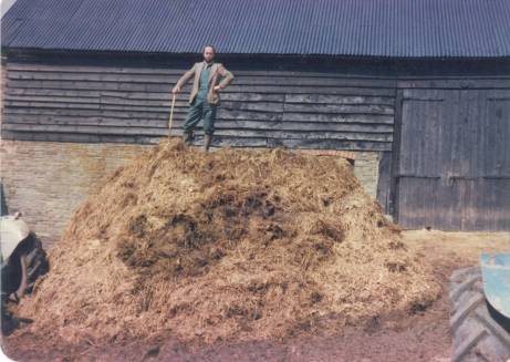
Figure 14: a winter's muck waiting to be spread
Squalid politics
Farming is always against a background of politics. It didn’t seem to interfere much at first – maybe that was the naivety of youth. The Agricultural Boards set prices and dished out entitlements every year. When a heifer first calved, a Man from The Ministry would come and punch a hole in her ear, and we would receive a small cheque. That seemed about the extent of it. To begin with ...
Throwing our lot in with Europe
Then we joined the European Economic Community. Initially, it brought incentives to drain the land, rationalise fields, to abandon our old buildings for new steel-framed concrete ones. It could not come soon enough for those of us who farmed in those small, dark, unhygienic, hard-to-maintain buildings. Ken launched in erecting the four steel-framed barns in the next decade, increasing his stock and improving the land. There were also incentives to re-roof barns, and with great energy and foresight, he replaced all our existing stone roofs, making Dukes Farm almost unique in having them intact.
All at sea in the EEC
Despite this, farming has not flourished the way the Europhiles prophesied because increased production came at a cost the public found unacceptable. Protected price regimes caused food mountains and wine lakes. Wildlife suffered. Deregulation of the animal feed industry caused the chilling BSE, and the paradoxical sight of John Gummer smilingly feeding a beef burger to his own small child, while boldly reassuring the nation, “We will slaughter the entire national herd of eleven million cattle if necessary.”
During the same years, tuberculosis has spread through the national cattle, deer and badger populations until it now hangs over every cattle farmer like the Sword of Damocles. It is costing millions to control; meanwhile resistant strains of the pathogen must be rubbing their hands with glee, especially as our armoury of antibiotics gets less effective. Who knows what the human cost may eventually be?
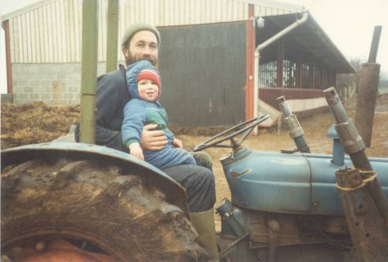
Figure 15: Ken & Michael in 1985
We weren’t just farming, of course. We had two sons, Michael and Laurence. The latter only stayed a while. At thirteen weeks, he died suddenly of a cot death, and is buried in Clodock churchyard. He was a robust and demanding baby, and Ken still maintains he would have been the farmer of the brood. Four years later, we had two more children in quick succession: Grace and Arthur. They were a chummy little pair whom we dubbed ‘the Smalls’. But none of them is a natural farmer. Mike’s degree is from Birmingham, and he is an engineer in the oil industry, Grace has a Genetics degree from Liverpool, and still lives there while training to teach, and Arthur is studying Medicine at Liverpool, so ‘the Smalls’ (not small, at all) are – quite coincidentally – still close.
The 2001 Foot and Mouth epidemic
Being an incurable scribbler, I kept a diary, and in 1995, I won the Farmers Weekly prize to supply their farmers’ wife diary. Life was full, satisfying and exhausting. Nothing prepared us for sudden change. It was on February 15th 2001, Ken popped his head back round the bedroom door: the radio said Foot and Mouth had broken out in Cumbria. It always makes farmers cock their ears. It was soon in Herefordshire, and while we were still spreading disinfected straw across the drive and unravelling the rumours, a dictate on contiguous culling issued us an ‘E notice’. All our livestock would be killed the next day. Which they were. Bolshy young bulls being prepared for sale, venerable old brood cows, tiny calves, all shot by a lone marksman where they stood, and carted away with hundreds of others in the valley to be buried in pits or burned.
It was medieval in its brutality and illogicality. We moved out for a day or so to escape the pall of smoke. Within a fortnight, I had a part-time job, Ken was a full time joiner, and the friendly Man from the Ministry (of Agriculture, Fisheries and Food) was suddenly transformed into a no-egg-on-our-faces Department of Environment, Food and Rural Affairs led by caravanning enthusiast, Mrs Margaret Beckett.
‘Tis an ill wind ...
Our old buildings were largely redundant and deteriorating, and we finally had time and energy – and the skills - to renovate them. We began with the Granary early in 2006, clearing out the butter churns and cheese press. We mapped the flagstones before lifting them to dig in the drainage and underfloor heating. They were ready in time for the Hay Festival, then we applied for planning permission for the next three barns. In 2007, we completed the ground works and a new home for the bats on the premises, and by Christmas 2008, two of the three barns were ready for visitors. It required ferocious speed and focus from our small but dedicated team. No wonder it still feels slightly as if we are on holiday! The third barn is still waiting for us across the yard – a brown-field site if ever there was one.
What is Craswall like now?
We look to the likes of John Clare, and the Romantic poets to articulate the pleasure of walking in a place to know and love it. Every day for forty years, Ken walked the farm to check the livestock, and every day for over twenty years the children and I walked down the lane to catch the school bus. Now they have left, walking to our neighbours and to my mother-in-law in the valley bottom maps a companionship with people and place that has few parallels in the modern world.
On the up
Craswall is a good place to live. It is on the up in a big way. Our parish population fell to its lowest in 1971 with only 111 inhabitants in forty dwellings. Since then, numbers have increased significantly. At the last published census in 2011, there were 153 of us, and seventy five residential addresses are registered. A few of those are second homes, but they still add to our housing stock - second homes can become first homes in the future.
It feels good to be popular. Craswall has also bucked the prevailing trend of farms being split up; their empty acres being annexed to another farm, with the farmhouse being offered for sale as ‘unspoilt character accommodation boasting a wealth of period features’. Most farms remain, like ours, intact, even if sources of income have changed. Many farmers and their wives work outside the home, or have other businesses. Craswall has also bucked the trend of ageing farmers. A high proportion of the current generation have stayed to farm, and Craswall has been blessed with nine babies in the last couple of years. Welcome to Sadie, Rees, Jack, Freddie, William, Ruby, Maisie, Ffion, and Connie. It is cause to rejoice.
As I reach the end, Ken asks me, ‘Have you included the drought of ’76?’
‘No, I haven’t,’ I say, cross to be reminded what I’ve missed, ‘nor the big snow of 1981, nor the winter of ’47.’ I have hardly mentioned the weather at all, though it is mostly what we talk about.
Which brings me to the final question we’re asked: Do you miss farming? Leaving aside the relentless work, I do miss the drama and colour of it. In the spirit of poets of the Marches – Thomas Traherne, Housman, John Masefield, John Betjeman, as well as the Dymock poets, it seems appropriate to answer – and finish - with a poem written by local Marches poet, Thoni Handy:
New Moon
The night was dark at Mochdre Farm. The cow
breathed heavily in pain,
Its sides swollen with coming birth. There was no rain
Though clouds masked the sky. She laboured, we men
Sweated with her as we pulled and comforted between
barnlight and roosting hen.
When the new moon broke from its womb of cloud
And lit the frost on the farmyard floor,
A wet calf stood on tottering legs, head bowed,
Puffing silver breaths; then it fell on the straw
And braced its body against the great licks of its
mother's tongue.
Outside, beneath where a cold baptism of stars was flung,
I watched the homeward men leave trails in the frost
Till they were folded into the mulberry darkness and lost.
Bibliography & notes
Alington, Gabriel: The Hereford Mappa Mundi / Gabriel Alington; illustrations by Dominic Harbou - Leominster : Gracewing, 1996
Pinkney, Tony: Raymond Williams . - Seren (Border Lines Series), 1991
Fraser, Maxwell: Welsh Border Country - London : Batsford, 1972
Miles, Jonathan: Eric Gill and David Jones at Capel-y-Ffin - Jonathan Miles . - Bridgend : Seren, 1992
Lewis, Colin: Herefordshire, the Welsh connection / Colin Lewis . - Conwy : Gwasg Carreg Gwalch, 2006
Shoesmith, Ron: Alfred Watkins A Herefordshire Man Logaston Press 1990
Taylor, Elizabeth: Kings Caple in Archenfield Logaston Press 1997
The Táin trans. Thomas Kinsella Dolmen Press 1969
Kelly’s Directory of Herefordshire 1922
Fox & Raglan Monmouthshire Houses Merton Priory Press and National Museum of Wales 1951, 2nd ed. 1994
Harley Millichap Poems of the Middle Marches 1988
Sean Street The Dymock Poets Seren (Border Lines Series) 1994
A History of St Mary’s Church Craswall
[i] Hen Allt : map OL13 233/399, on a footpath from Hay
[ii] Rowlestone Court Farmhouse Ice Cream (01981) 240322 HR2 0DW www.rowlestonecourt.co.uk woodland walks, Iron Age fort, limekiln, and wonderful home-made ice cream in their own café. Highly recommended! Leaflet in boot room.
[iii] Arthur’s Stone : map OL13 319/431 a great round trip taking in a walk across Merbach Hill
[iv] Cefn Hill – map OL13, 270/390 is crossed by the Three Rivers bridlepath, and very accessible for walking.
[v] ‘the top road ’ OL13 250/374 SW to the picnic site at 288/328
[vi] ‘ the Cefn road’ OL13 285/370 SW to and beyond 305/340
[vii] Poston Iron age fort, map OL13 359/377, inaccessible but nearby public footpath shows the site was chosen for its peerless view of the entire Golden Valley.
[viii] Llanveynoe church: map OL13 303/314
[ix] the Pandy to Hay stretch of Offa’s Dyke Footpath is one of the most scenic and demanding: 17 miles but do-able in a day by leaving a car at each end.
[x] Suggett Houses and History in the March of Wales 1400-1800
[xi] Hereford Cider Museum HR4 0LW 01432 354207
[xii] Westons , Much Marcle, HR8 2NQ 01531 660108
Ref: rs_cra_0100